

Alaska
Geology Resources - Alaska
-
Alaska Division of
Geological & Geophysical Surveys
-
Geology Publications (A few of the geology links available are listed below.)
- Alaska’s Mineral Industry (publication)
- Guide to Alaska’s Geologic and Mineral Information (publication)
- DGGS Annual Report (publication)
- Alaska Geosurvey News (newsletter)
- Mineral Resources
-
Geology Publications (A few of the geology links available are listed below.)
- AKGeology.info - “This new site will evolve from a collection of links pertaining to geology, minerals, and land records in Alaska into a integrated system which allows the user to combine this information in ways which promote minerals exploration in Alaska.”
- Alaska State Minerals Information (USGS)
- Alaska Geology Map Indexer (Downloadable Maps)
- Alaska Resource Data Files - Summary Descriptions of Known Mineral Occurrences
- Alaska Resources Library and Information Services (ARLIS)
- Alaska Science Forum – Rocks & Geology Index
- Road Cuts, Article #452, by T. Neil Davis, April 5, 1981
- Alaska’s Geology & Mineral Resources (Selected Products), U. S. Geological Survey (A few of the subjects available in the “Alaska’s Geology & Mineral Resources” section are listed below.)
- Alaska’s U. S. Geological Survey Mineral-Resources
Archive in Anchorage, Alaska – “Three
Western-Mineral-Resources Archives,” by Karen
Bolm, Dave Frank, and Jill L. Schneider, U. S. Geological Survey.
(PDF) (This article includes the history of these three
archives, photographs, and contact information.)
“Meeting the challenge of balancing America ’s needs for both nonrenewable resources and a clean, healthy environment requires accurate and unbiased scientific data. The ongoing work of U.S. Geological Survey (USGS) scientists provides information crucial to the creation of sound public policies that will ensure future supplies of mineral resources while protecting the health of our Nation’s citizens. Three archives, in Anchorage, Alaska, Spokane, Washington, and Tucson, Arizona, are maintained by the USGS to help policymakers, industry leaders, government officials, elected representatives, and the general public make informed decisions on mineral issues based on accurate, up-to-date, and impartial mineral-resource information….”
- The Brooks Range in northern Alaska – “Limestone: The Building Block for Tilting Brooks Range Peaks,” Article #1288, by Ned Rozell, Alaska Science Forum, June 6, 1996, Geophysical Institute, University of Alaska Fairbanks, in cooperation with the UAF research community.
-
Fossiliferous blue-black limestone beds in tramway cut 250 feet from wharf, Tokeen (Photograph) Wales district, Southeastern Alaska region, Alaska. 1912. Plate 10-A in U.S. Geological Survey. Bulletin 682. 1920. E. F. Burchard. (Photograph on the U. S. Geological Survey Photographic Library web site.)
- Geologic Map of Alaska, presented on the About.com: Geology web site.
- “Geology of the Chatham Sound region, southeast Alaska and coastal British Columbia,” by G. E. Gehrels, in Canadian Journal of Earth Sciences, Vol. 38, No. 11, November 2001, NRC Research Press, pp. 1579-1599 on the HighBeam Research web site.
- Geology of the Dry Pass Area, Southeastern Alaska, Geologic Report No. 7, by Gerald Herreid and M. A. Kaufman, Juneau, Alaska, June 1964, State of Alaska, Department of Natural Resources, Division of Mines and Minerals (in PDF format). (This publication includes a geologic map of the Dry Pass Area.)
- Juneau - John Rishel Mineral Information Center, Douglas, Alaska
- Ketchikan Quadrangle – Alaska Data Resource File (Descriptions of mineral occurrences), Open-File Report 99-525, by the U. S. Geological Survey in PDF format.
- A Location Guide for Rockhounds, Collected by Robert C. Beste, PG, St. Louis, Missouri: Hobbitt Press, 2nd ed., December 1996, 148 pp. (Includes chapters on “Mineral Locations by State,” “Appendix and Glossary,” and “Bibliography.”)
- Map Library, Alaska Department of Natural Resources.
- Map of Industrial Minerals Occurrences in Alaska, Miscellaneous Publication 43, by DeAnne S. Pinney and Emily S. Duenwald, Alaska Division of Geological & Geophysical Surveys, September 2001, 103 pp.
- National Geologic Map Database, presented by the United States Geologic Survey.
- Prince of Wales Island (article) – “Famous mineral localities: Green Monster Mountain Prince of Wales Island, Alaska,” in Mineralogical Record, Sep./Oct. 2004 by Douglas C. Toland, on the High Beam Research web site.
- Southeastern Coastal Alaska Limestone Terrain.
(The information below is excerpted from the above document,
which you can view as a PDF file at the URL below). The document
is presented by the Alaska Department of Natural Resources.)
This report was taken from a report "Limestones of the
Pacific Northwest" by Edwin Hodge, industrial raw materials
consultant, September 1, 1944, for the Bonneville Power
Administration. Report on file at Division of Mines and Geology
Library, General Administration Building, Olympia, Washington.
(The online version contains many typographical errors. I have
taken the liberty to correct these errors, so the following
paragraph is a "corrected" version of this document
quotation.) (The link from which this information was obtained
is no longer available.)
<http://wwwdggs.dnr.state.ak.us/scan1/mr/text/MR191-08.PDF>Many limestone and marble deposits occur adjacent to the coast of southeastern of which more than 56 locations are noted in this report.
Transportation: All of the limestone deposits herein recorded lie close to tidal waters. Many of the limestones outcrop as cliffs on the shores of sheltered waters where good quarry sites may be found and safe and economical wharfage is available.
(There is a section of the report entitled, "Comparison of Composition of Limestones of Southeastern Alaska" which lists the location and description of marble and limestone found.)
-
Tokeen, Alaska – Photographs of Tokeen, Alaska, available on the U. S. Geological Survey Photographic Library web site. (Use search window to search for “Tokeen Alaska”)
Research Resources - Alaska
- Archives
- Historical
Sources
- Alaska, in the Catholic Encyclopedia, presented on the New Advent web site.
- Alaska Buildings, Structures, & Architects on the Philadelphia Architects & Buildings Project (PAB) web site. You can search the database for buildings, structures, and architects either as a visitor or you can register free. You cannot search for specific cities, but you can search for county locations. There are no photographs presented, but the location and/or address and the name of the architect are included if known; and the historic registration information is also included.
- AlaskaGenWeb Project Web Site, State Coordinators Capt. Pat Smith or Sarah Ligon.
- Alaska Historical and Genealogical Societies
- Alaska Historical Collections (Includes Online Collections, Photographs & Still Images, Manuscripts & Records, Books & Periodicals, Newspapers, Maps, and Multimedia)
- Alaska Historical Files, Alaska State Library Historical Collections, Bayers, Lloyd H., 1911-1968, Captain Lloyd H. “Kinky” Bayers Collection, 1898-1967, MS 10. (Subjects included on the note cards are: (1) “Marble” Marble discovered on Prince of Wales Island near Shakan; Vermont Marble Co. marble quarries at Shakan and Tokeen; Marble discovered by Vermont Marble Co. at El Capitan Pass; the Tokeen marble plant; and (2) “Mines and Mining”: “3. Alaskan (Sitka) History of Alaska Marble (John the Baptist Bay—1874”)
- Alaska Historical Society
- Anchorage Borough, Alaska Genweb Project (historical research resources)
- Alaska History & Cultural Studies, by the Alaskan Humanities Forum.
- Tokeen on Marble Island (Scroll down to this section.)
- Alaska State Library Historical Collections
- Alaska Mining Hall of Fame Foundation
- Gallery of Historic Photos of Juneau, Alaska and Vicinity (Most of the photographs presented here are from the collections of the Alaska State Library.)
- Historical Construction Equipment Association
- The Lighthouses of Alaska
- Local Historical Societies and Museums
-
The Naming of Alaska: The Explorers, by Murray Lundberg, on the About ExploreNorth web site.
http://explorenorth.com/library/history/geodic-ak-1902.html
“By 1900, most of Alaska had been explored by Europeans. From the Russians on the coast in 1741 to the U.S. military expeditions and traders and prospectors from many nations in the interior in later years, there were few locations left that had not been seen by the newcomers.
“In exploring new regions, the naming of geographical features is important so that other travelers can identify the routes that had been used previously….”
- National Archives and Records Administration – Pacific Alaska Region
- Office of History and Archeology, Alaska Department of Natural Resources, Division of Parks and Outdoor Recreation.
- Railways of Alaska – Rails to Riches: Historic Railways of Alaska and the Yukon Territory, by Murray Lundberg, presented on the Railsnorth.com web site.
-
Southeast Alaska’s Marble History, presented by Fathom Stone of Whistler, British Columbia.
- Steel Lines Around the Circumpolar North, presented on the Railsnorth.com web site.
- Libraries
- Alaska Library Web Sites, Alaska Library Association.
- Alaska Photo Library, Department of Community and Economic Development.
- Alaska Resources Library and Information Services (ARLIS)
- Alaska State and Local Government, Library of Congress.
- Alaska State Library
- Statewide Library Electronic Doorway (SLED), Information resources for, about, and by Alaskans.
- University of Alaska Anchorage-Consortium Library
- William A. Egan Library - University of Alaska Southeast
-
Museums
- Alaska Museum of Natural History
- Alaska State Museums
- Alutiiq Museum and Archaeological Repository, Kodiak, Alaska.
- Anchorage Museum of History and Art, Anchorage, Alaska.
- Carrie M. McLain Memorial Museum, Nome, Alaska.
- The Hammer Museum, Haines, Alaska, presented by Dave Pahl.
- Kodiak Military History Museum, Miller Point, Fort Abercrombie, Kodiak, Alaska.
- Museum of Alaska Transportation and Industry, Wasilla, Alaska.
- Museum of History and Industry
- Museums and Historical Societies in Alaska
- Pioneers of Alaska, Historic Preservation Committee, Anchorage, Alaska.
- University of Alaska Museum, Fairbanks, Alaska.
- Valdez Museum & Historical Archive
- Other
- 1895 U.S. Atlas – Alaska
- Alaska Facts: State of Alaska
- Alaska Paleontology Database
- Alaska Scenic Byways, presented by the National Scenic Byways Program.
- Bureau of Land Management (BLM) - Alaska's Electronic Reading Room, United States Department of the Interior, Bureau of Land Management.
- Camera Workers: British Columbia, Alaska & Yukon 1858-1950. Documents photographers in British Columbia and the Alaska and Yukon territories. Presented by David Mattison.
- Cyndi's List Online Research Resources - Alaska
- Databases for Alaskans and Authorized Users
- Everything Alaska: Your On-Line Source For All Things Alaskan
- Ghost Towns of Alaska
- Land Records Information Section (LRIS)
-
Mat-Su Valley Frontiersman, an online newspaper
- Prince of Wales Online (Information on Prince of Wales Island, Alaska)
- Prince of Wales: the ultimate escape? – Prince of Wales Island, Alaska, in American Forests, Jan.-Feb. 1990, by Herbert E. McLean, on Questia. (Includes “Quarry camping in Alaska.”)
- State of Alaska
- State of Alaska: Travel and Vacation Information
- Statewide Library Electronic Doorway Home Page
- US Board on US Geographic Names - The New U. S. and Territories Query (Search the USGS Geographic Names Database.)
- Western Miner (This web site includes a directory of available prospects.)
- Wild Alaska, presented by Dick Gibson. (One of the very interesting photographs available on this web site is: “Dikes and sills in Silurian limestone and marble.”)
- World Almanac for Kids Online – Alaska
- Yale Peabody Museum: GNIS - Alaska (Search the USGS Geographic Names Database)
The Alaska Stone Industry
- 1882 - The Alaska Stone and Building Industry in 1882 (transcription), Excerpts from Mineral Resources of the United States, Calendar Year 1882, J. S. Powell, Director, Department of the Interior, United States Geological Survey, Government Printing Office, Washington, D. C., 1883. Excerpts from the chapters on 1) "Structural Materials" and 2) "The Useful Minerals of the United States."
- 1883 and 1884 Alaska Stone Industry (transcription), Excerpts from Mineral Resources ofthe United States - Calendar Years 1883 and 1884 (PDF images of sections), Department of the Interior, United States Geological Survey, Government Printing Office,Washington, D. C., 1885.
- 1885 - The Alaska Stone and Building Industry in 1885 (transcription), Mineral Resources of the United States, Calendar Year 1885 (PDF images of sections), David T. Day, Geologist, Department of the Interior United States Geological Survey, Government Printing Office, Washington, D. C., 1887. Excerpt from the chapter on "Structural Materials," by H. S. Sproull.
- 1886 - The Alaska Stone and Building Industry in 1886 (transcription), Excerpts from Mineral Resources of the United States, Calendar Year 1886 (PDF images of sections), David T. Day, Chief of Division of Mining Statistics and Technology, Department of the Interior, United States Geological Survey, Government Printing Office, Washington, D. C., 1887. Excerpts from the chapter on "Structural Materials," by William C. Day.
- 1887 - The Alaska Stone and Building Industry, 1887, Excerpts from Mineral Resources of the United States - Calendar Year 1887 (PDF images of sections), J. W. Powell, Director, David T. Day, Chief of Division of Mining Statistics and Technology, Department of the Interior, United States Geological Survey, Government Printing Office, Washington, D. C., 1888
- 1888 - The Alaska Stone and Building Industry, 1888, Excerpts from Mineral Resources of the United States - Calendar Year 1888 (PDF images of sections), J. W. Powell, Director, David T. Day, Chief of Division of Mining Statistics and Technology, Department of the Interior, United States Geological Survey, Government Printing Office, Washington, D. C., 1890
- 1889 and 1890 - The Alaska Stone and Building Industry, 1889, Excerpts from Mineral Resources of the United States - Calendar Year 1889 and 1890 (PDF images of sections), J. W. Powell, Director, David T. Day, Chief of Division of Mining Statistics and Technology, Department of the Interior, United States Geological Survey, Government Printing Office, Washington, D. C., 1892
- 1891 - The Alaska Stone and Building Industry, 1891, Excerpts from Mineral Resources of the United States - Calendar Year 1891 (PDF images of sections), J. W. Powell, Director David T. Day, Chief of Division of Mining Statistics and Technology, Department of the Interior, United States Geological Survey, Government Printing Office, Washington, D. C., 1893
- 1892 - The Alaska Stone and Building Industry, 1892, Excerpts from Mineral Resources of the United States - Calendar Year 1892 (PDF images of sections), J. W. Powell, Director, David T. Day, Chief of Division of Mining Statistics and Technology, Department of the Interior, United States Geological Survey Government Printing Office, Washington, D. C., 1893
- 1893 - The Alaska Stone and Building Industry, 1893, Excerpts from Mineral Resources of the United States - Calendar Year 1893 (PDF images of sections), J. W. Powell, Director, David T. Day, Chief of Division of Mining Statistics and Technology, Department of the Interior, United States Geological Survey, Government Printing Office, Washington, D. C., 1894
- 1894 - The Alaska Stone and Building Industry, 1894, Excerpts from Sixteenth Annual Report of the United States Geological Survey (PDF images of sections), Part IV. Mineral Resources of the United States, 1894, Nonmetallic Products, Washington: Government Printing Office, 1894.
- 1895 - The Alaska Stone and Building Industry, 1895, Excerpts from Seventeenth Annual Report of the United States Geological Survey (PDF images of sections), Part III. Mineral Resources of the United States, 1895, Nonmetallic Products, Except Coal. Washington: Government Printing Office, 1896.
- 1896 - The Alaska Stone and Building Industry, 1896, Excerpts from Eighteenth Annual Report of the United States Geological Survey (PDF images of sections), Part V. Mineral Resources of the United States, 1896, Nonmetallic Products, Except Coal. Washington: Government Printing Office, 1897.
- 1897 - The Alaska Stone and Building Industry, 1897, Excerpts from Nineteenth Annual Report of the United States Geological Survey (PDF images of sections), Part V. Mineral Resources of the United States, 1896, Nonmetallic Products, Except Coal. Washington: Government Printing Office, 1898.
- 1898 - The Alaska Stone and Building Industry, 1898, Excerpts from Twentieth Annual Report of the United States Geological Survey (PDF images of sections), Part VI. Mineral Resources of the United States, 1898, Nonmetallic Products, Except Coal and Coke. Washington: Government Printing Office, 1899.
- 1899 - The Alaska Stone and Building Industry, 1899, Excerpts from Twenty-first Annual Report of the United States Geological Survey (PDF images of sections), Part VI. Mineral Resources of the United States, 1899, Nonmetallic Products, Except Coal and Coke. Washington: Government Printing Office, 1901.
- 1900 - The Alaska Stone and Building Industry, 1900, Excerpts from Mineral Resources of the United States - Calendar Year 1900 (PDF images of sections), Charles D. Walcott, Director, David T. Day, Chief of Division of Mining and Mineral Resources, Department of the Interior, United States Geological Survey, Government Printing Office, Washington, D. C., 1901
- 1901 - The Alaska Stone and Building Industry, 1901, Excerpts from Mineral Resources of the United States - Calendar Year 1901 (PDF images of sections), Charles D. Walcott, Director, David T. Day, Chief of Division of Mining and Mineral Resources, Department of the Interior, United States Geological Survey, Government Printing Office, Washington, D. C., 1902
- 1902 - The Alaska Stone and Building Industry, 1902, Excerpts from Mineral Resources of the United States, Calendar Year 1902 (PDF images of sections), Charles D. Walcott, Director, Department of the Interior, United States Geological Survey, Government Printing Office, Washington, D. C., 1904.
- 1903 - The Alaska Stone and Building Industry, 1903, Excerpts from Mineral Resources of the United States, Calendar Year 1903 (PDF images of sections), Charles D. Walcott, Director Department of the Interior, United States Geological Survey, Government Printing Office, Washington, D. C., 1904.
- 1904 - The Alaska Stone and Building Industry, 1904, Excerpts from Mineral Resources of the United States, Calendar Year 1904 (PDF images of sections), Charles D. Walcott, Director, Department of the Interior, United States Geological Survey, Government Printing Office, Washington, D. C., 1905.
- 1905 - The Alaska Stone and Building Industry, 1905, Excerpts from Mineral Resources of the United States - Calendar Year 1905 (PDF images of sections), Charles D. Walcott, Director, Department of the Interior, United States Geological Survey, Government Printing Office, Washington, D. C., 1906.
- 1906 - The Alaska Stone and Building Industry, 1906, Excerpts from Mineral Resources of the United States - Calendar Year 1906 (PDF images of sections), George Otis Smith, Director, Department of the Interior, United States Geological Survey, Government Printing Office, Washington, D. C., 1907.
- 1907 - The Alaska Stone and Building Industry, 1907, Excerpts from Mineral Resources of the United States, Calendar Year 1907 (PDF images of sections), Part II. Nonmetallic Products, George Otis Smith, Director, Department of the Interior, United States Geological Survey, Government Printing Office, Washington, D. C., 1908.
- 1908 - The Alaska Stone Industry, 1908 (transcription), Excerpt from Mineral Resources of the United States, Calendar Year 1908 (PDF images of sections), Part II - Nonmetallic Products, Department of the Interior, United States Geological Survey, Government Printing Office, Washington, D. C., 1909. Excerpts from the book from chapter on "Stone," by A. T. Coons.
-
1912 – Marble Resources in Ketchikan & Wrangell Districts of Alaska – Excerpts from Marble Resources of Ketchikan and Wrangell Districts, by Ernest F. Burchard, U.S. Geological Survey Bulletin No. 542-B, 1913. (This book is available on Google Books.)
-
1918 – Marble Resources for Alaska circa 1918 – Excerpt from Mineral Resources of the United States for 1918, Part 2 Non-Metals, R. W. Stone, Geologist in Charge, “Stone,” by G. F. Loughlin and A. T. Coons, 1921, pp. 1240. (This book is available on Google Books. )
- 1994 through 2009 – The Mineral Industry of Alaska–U. S. Bureau of Mines, U. S. Department of the Interior - 1994 through 2008.
- 2001 – Alaska’s Industrial Minerals – “An Overview of Alaska’s Industrial Minerals,” by Thomas K. Bundtzen, Pacific Rim Geological Consulting, Inc., Fairbanks, Alaska, USA, in The Geology of Western North America (Abridged Version), by JoAnne Nelson, British Columbia Ministry of Energy and Mines, Victoria, BC, Canada, 37th Forum on the Geology of Industrial Minerals, May 23-25, 2001, Victoria, British Columbia, Canada, pp. 3-4.
-
2010 – Alaska Rock Quarry Potential – Rock Quarry Potential: Preliminary Investigation, State of Alaska, November 2010, Prepared by the U.S. Army Corps of Engineers, Alaska District, in cooperation with State of Alaska, Department of Transportation and Public Facilities.
-
2013 – Alaska’s Mining Industry – Background, presented by the Resource Development Council.
-
The Alaska Marble Story, by Joseph Conrad, Stone Cutter, February 19, 2014.
- Alaska Miners Association
- The Northwest Mining Association
(From the web site) “Northwest Mining Association (NWMA) is a 113-year-old, 1,800 member non-profit, non-partisan trade association founded in Spokane, Washington during the early years of the Coeur d'Alene Mining District. We were soon supporting the mining industry throughout the states of Alaska, Idaho, Montana, Oregon, and Washington, the provinces of Alberta and British Columbia, and the Yukon and Northwest Territories.”
-
Southeast Alaska’s Marble History, presented by Fathom Stone of Whistler, British Columbia.
- The
Southeastern Alaska Mining Industry: Historical Overview and
Current Status,
by John Sisk, Southeast Alaska Conservation Assessment – Chapter
9.7, 5 pp. (in PDF format)
According to this document, “Marble was quarried from islands on the west coast of Prince of Wales Island from 1895 through 1932. Alaska marble was used in buildings from California and Nevada across the United States (Roppel 1991).”
Printed & Online Sources
- “Alaska,” in The Encyclopedia Britannica: A Dictionary of Arts, Sciences, Literature and General Information, Encyclopedia Britannica, 1910, pp. 472-477. (This book is available on Google Book Search for reading or downloading to your computer in PDF format.)
- “Alaska,” in New International Yearbook: A Compendium of the World’s Progress for the year 1910, Frank Moore Colby, editor, and Allen Leon Churchill, associate editor, 1909, pp. 19-21. (This book is available on Google Book Search for reading or downloading to your computer in PDF format on Google Book Search.)
- Alaska: A Guide to Alaska, Last American Frontier, by Merle Colby, Federal Writers’ Project, U.S. History Publishers, 1944, ISBN 1603540024, 9781603540025. (This book is available on Google Book Search for reading or downloading to your computer in PDF format.)
- Alaska Almanac, by Edward Sanford Harrison, compiled by Edward Sanford Harrison, The Harrison Publishing Company, 1909.
- Alaska, An Empire in the Making, by John Jasper Underwood. Dodd, Mead and co., 1913, 440 pp. (This book is available for reading or downloading to your computer in PDF format on Google Book Search.) (This book includes information on marble tombstones and marble quarries, pp. 233-234.)
- Alaska and Its Resources, by William Healey Dall, Lee and Shepard, 1897, 627 pp. (This book is available for reading or downloading to your computer in PDF format on Google Book Search.)
-
Alaska Bibliography, presented on the Anchorage Borough, Alaska GenWeb Project web site.
- Alaska Facts and Symbols, by Muriel L. Dubois, Capstone Press, 2003, 24 pp., ISBN 0736822321, 9780736822329.
-
Alaska Historical Timeline, presented on the Anchorage Borough, Alaska GenWeb Project web site.
- Alaska History: An Annotated Bibliography, by Marvin W. Falk, compiled by Marvin W. Falk, Greenwood Publishing Group, 2006, 371 pp., ISBN 0313282242, 9780313282249.
- Alaska in Transition: The Southeast Region, by George William Rogers, Published for Resources for the Future by Johns Hopkins Press, 1960, 384 pp.
- Alaska: It’s Resources and Development, United States Natural Resources Committee, Alaska Resources Committee, B. Frank Heimtzleman and Robert Marshall, Washington: U. S. Government Printing Office, 1938. (This book is available on the Internet Archive.)
-
The Alaska Marble Story, by Joseph Conrad, Stone Cutter, February 19, 2014.
-
Alaska Native People of South Central and Upper Cook Inlet Alaska, by Colleen Mielke, presented on the Anchorage Borough, Alaska GenWeb Project web site.
- Alaska, Our Beautiful Northland of Opportunity: A description of its Rivers, Mountains, Glaciers, Volcanoes, and other Beautiful and Unusual Scenic Features of the Rare Delights...: Our Beautiful Northland of Opportunity, by Agnes Rush Burr, The Page Co., 1919, 428 pp. (This book is available for reading or downloading to your computer in PDF format on Google Book Search.)
-
“Alaska’s Mineral Industry 2001,” Special Report 56, Division of Geological and Geophysical Surveys in cooperation with Division of Community & Business Development, Division of Mining, Land & Water.
-
Alaskan Geographic Names, by Marcus Baker, Excerpt from U.S.G.S. Annual Report No. 21, presented on the Anchorage Borough, Alaska GenWeb Project web site.
- “The Alaskan Mining Industry in 1913,” by A. H. Brooks, in Bulletin 592, Department of the Interior, United States Geological Survey, Washington: Government Printing Office, 1914, pp. 45-74.
- “The Alaskan Mining Industry in 1914,” by A. H. Brooks, in Bulletin 622, Department of the Interior, United States Geological Survey, Washington: Government Printing Office, 1915, pp. 15-68.
- “The Alaskan Mining Industry in 1915,” by A. H. Brooks in Bulletin 642, Department of the Interior, United States Geological Survey, Washington: Government Printing Office, 1916, pp. 17-72.
- “The Alaskan Mining Industry in 1916,” by A. H. Brooks, in Bulletin 662, Department of the Interior, United States Geological Survey, Washington: Government Printing Office, 1917, pp. 11-62.
- “The Alaskan Mining Industry in 1917,” by G. C. Martin, in Bulletin 692, Department of the Interior, United States Geological Survey, Washington: Government Printing Office, 1918, pp. 11-42.
- “The Alaskan Mining Industry in 1918,” by G. C. Martin, in Bulletin 712, Department of the Interior, United States Geological Survey, Washington: Government Printing Office, 1919, pp. 11-52.
- “The Alaskan Mining Industry in 1919,” by A. H. Brooks and G. C. Martin, in Bulletin 714, Department of the Interior, United States Geological Survey, Washington: Government Printing Office, 1921, pp. 59-95.
- “Alaska’s Mineral Supplies,” by A. H. Brooks, in United States Geological Survey Bulletin 666-P, United States Geological Survey, Washington, D.C., Government Printing Office, pp. 1-14.
- Alaska’s Mineral Supplies, by A. H. Brooks, in Bulletin 714, United States Geological Survey, Washington: Government Printing Office, 1921, pp. 5-57.
- “Alaska’s Mineral Wealth,” in Our New Alaska, by Charles Hallock, Ayer Publishing, 1970, 209 pp., ISBN 0405026706, 9780405026706. (Information on Alaskan marble quarries is included in this book.)
- Alaska’s Minerals as a Basis for Industry, by H. F. Bain, Bureau of Mines Information Circular 7379, 1964, 89 pp.
- Alaska’s Southeast: Touring the Inside Passage, by Michelle Gurney, Globe Pequot, 2006, 315 pp., ISBN 0762738901, 9780762738908.
- Alaska’s Southeast: Touring the Inside Passage, by Mike Miller, GPP Travel, (eleventh edition) May 13, 2008, 304 pp., ISBN-10: 0762745355, ISBN-13: 978-0762745357.
- An Abridged History of Alaska, by John W. Brown, 1909. (The text of this book is available on the Internet Archive web site.)
- “The Building Stones and Materials of Southeastern Alaska,” by C. W. Wright, in United States Geological Survey Bulletin 345b, United States Geological Survey, Washington, D.C., Government Printing Office, 1908, pp. 116-126.
-
Chronologies of Alaska and Regional Newspapers, Alaska State Library.
- “Conditions in Alaska,” in The Vermonter: A State Magazine, March 1904, pp. 233.
- “Economic Developments in Southeastern Alaska,” Bulletin 259, by F. E. and C. W. Wright, in Bulletin 259, Department of the Interior, United States Geological Survey, 1905, pp. 47-68.
- Fortunes from the Earth: An History of the Base and Industrial Minerals of Southeast Alaska, by Patricia Roppel, Sunflower University Press, 1991, 139 pp., ISBN 0897451368, 9780897451369.
- The Geography and Geology of Alaska, A Summary of Existing Knowledge, by A. H. Brooks, with a section on climate, by Cleveland Abbe, Jr., and a topographic map and description thereof, by R. U. Goode. Professional Paper 45, 1906, 327 pp.
- Geographic Dictionary of Alaska, Bulletin 299, by Marcus Baker, second edition, prepared by James McCormick, 1906, 690 pp. (This book is available on Google Book Search for reading or downloading to your computer in PDF format.)
- “Geography of Alaska,” in The United States Geological Survey: Its Origin, Development, Organization, and Operations, Department of the Interior, United States Geological Survey, Washington: Government Printing Office, 1904, pp. 33-48. (Includes map: “Map of Alaska, Showing Progress of Topographic and Geologic Surveys, 1898-1903.”)
- “Geologic Survey of Alaska, by Alfred H. Brooks, U. S. Geological Survey, in Popular Science Monthly, McClure, Phillips and Co., 1906, pp. 42-54. (This book is available on Google Book Search – Full View Books.)
- "The Geology and Mineral Resources of Kenai Peninsula," by G. C. Martin, B. L. Johnson, and U.S. Grant, in United States Geological Survey Bulletin 587, United States Geological Survey, Washington, D.C., Government Printing Office, 1915, pp. 243.
- "The Geology and Mineral Resources of Parts of Alaska Peninsula," by W. W. Atwood, in United States Geological Survey Bulletin 467, United States Geological Survey, Washington, DC., Government Printing Office, 1911, pp. 137.
- "The Geology and Mineral Resources of the Nizina District, Alaska," by F. H. Moffit and S. R. Capps, in United States Geological Survey Bulletin 448, United States Geological Survey, Washington, D.C., Government Printing Office, 1911, pp. 111.
- "The Geology and Mineral Resources of the Solomon and Casadepaga Quadrangles, Seward Peninsula, Alaska," by P. S. Smith, in United States Geological Survey Bulletin 433, United States Geological Survey, Washington, D.C., Government Printing Office, 1910, 227 pp.
- "The Geology and Mineral Resources of the West Coast of Chichagof Island," by R. M. Overbeck, in United States Geological Survey Bulletin 692, United States Geological Survey, Washington, D.C., Government Printing Office, 1919, pp. 91-136.
- Geology of Southeast Alaska: Rock and Ice in Motion, by Harold Stowell, University of Alaska Press, March 1, 2006, 152 pp., ISBN-10: 188996381X, ISBN-13: 978-1889963815.
- Geology of the Dry Pass Area, Southeastern Alaska, Geologic Report No. 7, by Gerald Herreid and M. A. Kaufman, Juneau, Alaska, June 1964, State of Alaska, Department of Natural Resources, Division of Mines and Minerals (in PDF format). (This publication includes a geologic map of the Dry Pass Area.)
- Glimpses of Alaska, As It Was and As It Is, by Alaska territorial chamber of commerce, Chamber of Commerce, Alaska Chamber of Commerce, Alaska, The Chamber, 1938, 111 pp.
- Guide to Alaska and the Yukon, ed. by Lou Jacobin, Guide to Alaska Co., Juneau, Alaska, 1956, 288 pp.
- A Guide to Alaska, Last American Frontier, by Merle Colby, Macmillan Co., New York, 1939, 427 pp.
- Handbook of Alaska: Its Resources, Products and Attractions, by Adolphus Washington Greely, C. Scribner, 1914, 280 pp. (This book is available for reading or downloading to your computer in PDF format on Google Book Search. This book includes information on Alaskan marble quarries and industry.)
- History of Mines and Prospects, Ketchikan District, Prior to 1952, SR 1, by John Bufvers, Alaska Department of Natural Resources publication, 1967, 32 pp.
-
Inactive Production Rock Sites and Quarries, 2002 Annual Report, Kennecott Greens Creek Mining Company, August 2003.
-
Inactive Production Rock Sites and Quarries, 2011 Annual Report, Hecla Greens Creek Mining Company, April 15, 2012.
- "Investigation of the Mineral Deposits of Seward Peninsula," by P. S. Smith, in United States Geological Survey Bulletin 345, United States Geological Survey, Washington, D.C., Government Printing Office, 1908, pp. 206-250.
- Juneau Township Historic Building Survey, City and Bureau of Juneau, September 1988 (in PDF format).
- The Ketchikan and Wrangell Mining Districts, Alaska, Bulletin 347, by Fred Eugene Wright and Charles Will Wright, U. S. Geological Survey, Government Printing Office, 1908. (This book is available for reading or downloading to your computer in PDF format on Google Book Search.) (The section on “Building Stones” includes information on the following subjects: Marble, granite, and cement, pp. 191-200.)
-
Knik Arm Crossing – Final Potential Armor and Rock Quarries Technical Report, Agreement No: P 42070, Federal Project No: ACSTP-0001(277), Aksas Project No: 56047, Prepared for: Knik Arm Bridge and Toll Authority, Anchorage, AK 99501, Prepared by: PND Engineering, Inc., January 2006. (Includes quarry photos and map of quarries.) (“Active Quarries” listed in this report: Peters Creek – Rock Alaska; Peters Creek – Skookum Quarry; Palmer – Lucas Pit; Butte – Back Acres Quarry; Talkeetna – Curry Quarry; Spencer; Seward – 4th of July; Seward, Resurrection Creek; Valdez; Cordova/Shepard Point; Chignik/Lagoon-Indian Creek, Castle Bay; Sand Point: Knoll Quarry and Harbor Quarry; King Cove; Saint George; Dutch Harbor; Dillingham; and Cape Nome. “Undeveloped Unpermitted Quarries”: Chugiak Bay/Chug 1 near Port Graham; Iniskin Bay; Cordova/Shepard Point; and the Kodiak/Anton Larsen Pit.)
-
“The Lost Trade of Stone Cutting,” An essay by Joseph Conrad describing stone construction before gang saws or compressed air, 1800 to 1900, April 19, 2012
- A Location Guide for Rockhounds, (PDF) Collected by Robert C. Beste, PG, St. Louis, Missouri: Hobbitt Press, 2nd ed., December 1996, 148 pp. (Includes chapters on “Mineral Locations by State,” “Appendix and Glossary,” and “Bibliography.”)
- Map of Alaska Showing Distribution of Mineral Deposits, scale 1:5,000,000; by A. H. Brooks. New editions included in United States Geological Survey Bulletins 642 and 662, United States Geological Survey, Washington, D.C., Government Printing Office.
- Map of Industrial Minerals Occurrences in Alaska, Miscellaneous Publication 43, by DeAnne S. Pinney and Emily S. Duenwald, Alaska Division of Geological & Geophysical Surveys, September 2001, 103 pp.
- "Marble Deposits of Southeastern Alaska," by E. F. Burchard, in United States Geological Survey Bulletin 682, United States Geological Survey, Washington, D.C., Government Printing Office, date unknown, pp. unknown. (Report in preparation in 1917.)
- “Marble in Alaska,” in the Journal of the Franklin Institute, by Franklin Institute, Philadelphia, Pa., Pergamon Press, 1902, pp. 309-310. (This book is available for reading or downloading to your computer in PDF format on Google Book Search.)
- “Marble in Juneau, Skagway, and Sitka Districts – Topographic and Commercial Relations,” in Analyses of Rocks and Minerals from the Laboratory of the United States Geological Survey, 1880 to 1914, by Frank Wigglesworth Clarke, U. S. Government Printing Office, 1915, pp. 97-107. (This book is available for reading or downloading to your computer in PDF format on Google Book Search.)
- “Marble On The Edge,” by Gary McWilliams, in Wanderlusting, 2015, published by Great Story Book Publishing. (“Marble on The Edge” is the story about Gary McWilliams’ search for his “Jupiter Marble” on Dall Island, Alaska. This book also includes accounts of his many adventures. You can learn more about Gary McWilliams, adventurer and sculptor, on his web site Stone Arts of Alaska.)
- “Marble Resources of Ketchikan and Wrangell Districts,” by E. F. Burchard, in United States Geological Survey Bulletin 542, United States Geological Survey, Washington, D.C., Government Printing Office, 1913, pp. 52-77. (This book is available on the U. S. Geological Services web site at the link above.)
- Marble Resources of Southeastern Alaska, Bulletin 682, by Ernest F. Burchard, Department of the Interior, United States Geological Survey, Washington: Government Printing Office, 1920.
- "Marble Resources of the Juneau, Skagway, and Sitka Districts," by E. F. Burchard, in United States Geological Survey Bulletin 592, United States Geological Survey, Washington, D.C., Government Printing Office, 1914, pp. 95-107.
- “The Marbles of Alaska” in Stone: An Illustrated Magazine, Vol. XXXVII, No. 11, November 1916, pp. 583-584. (This magazine is available on Google Book Search for reading or downloading to your computer in PDF format.)
- The Milepost: for Motorists, Sportsmen, Vacationists, Alaska Research Co., Anchorage, Alaska. (Annual booklet of highway maps and detailed information covering the Laska highway.)
- "The Mineral Deposits of Alaska," by A. H. Brooks, in United States Geological Survey Bulletin 592, United States Geological Survey, Washington, D.C., Government Printing Office, 1914, pp. 18-44.
- "The Mineral Deposits of the Chitina Valley," by F. H. Moffit, in United States Geological Survey Bulletin 642, United States Geological Survey, Washington, D.C., Government Printing Office, 1916, pp. 129-136.
- "Mineral Deposits of Kodiak and the Neighboring Islands," by G. C. Martin, in United States Geological Survey Bulletin 542, United States Geological Survey, Washington, D.C., Government Printing Office, 1913, pp. 125-136.
- "Mineral Deposits of the Kotsina-Kuskulana District, With Notes on Mining in Chitina Valley," by F. H. Moffit, in United States Geological Survey Bulletin 622, United States Geological Survey, Washington, D.C., Government Printing Office, 1915, pp. 103-117.
- "The Mineral Deposits of the Yakataga Region," by A. G. Maddren, in United States Geological Survey Bulletin 592, United States Geological Survey, Washington, D.C., Government Printing Office, 1914, pp. 119-154.
- Mineral Resources of Alaska: Report on Progress of Investigations in 1907, Bulletin 345, Alfred Hulse Brooks, U. S. Geological Survey, U.S. Government Printing Office, 1908, 294 pp. (This book is available on Google Book Search for reading or downloading to your computer in PDF format.)
- Mineral Resources of Alaska: Report on Progress of Investigations in 1908, Bulletin 379, Alfred H. Brooks and Others, U. S. Geological Survey, U.S. Government Printing Office, 1909. (This book is available on Google Book Search for reading or downloading to your computer in PDF format.)
- Mineral Resources of Alaska: Report on Progress of Investigations in 1910, by Alfred Hulse Brooks, U. S. Geological Survey, Government Printing Office, 1911, 333 pp. (This book is available for reading or downloading to your computer in PDF format on Google Book Search.)
- Mineral Resources of Alaska: Report on Progress of Investigations in 1911, Bulletin 520, by Alfred H. Brooks and Others, Department of the Interior, United States Geological Survey, Washington: Government Printing Office, 1912.
-
Mineral Resources of Alaska: Report on Progress of Investigations in 1914, Bulletin 622, by Alfred Brooks and others, U. S. Geological Survey, Government Printing Office, Washington, 1915. (This book is available on Google Books for reading or downloading to your computer in PDF format.)
- Mineral Resources of Alaska: Report on Progress of Investigations in 1919, Bulletin 714, by Alfred H. Brooks and Others, Department of Interior, United States Geological Survey, Washington: Government Printing Office, 1921.
- Mineral Industry of Alaska in 1929 and Administrative Report, by Philip Sidney Smith, U. S. Geological Survey, published by U.S. Govt. Print. Off., 1930, 120 pp.
- The Mineral Industry of Alaska in 1939, Technology & Science U. S. Geological Survey Bulletin 926A, by Philip S. Smith, United States Geological Survey, Washington, D.C.: 1941. 107 pp.
- Mineral Industry of Alaska in 1940, United States Geological Survey Bulletin 933-A, by Philip S. Smith, 1942, 102 pp.
- Mineral Resources in Alaska, Report of Progress of Investigations in 1909, United States Geological Survey, Bulletin 442, by Alfred H. Brooks and Others, Washington: Government Printing Office, 1910, 432 pp.
- Mineral Resources of Alaska: Report on Progress of Investigations in 1917, Bulletin 692, by G. C. Martin, et. al., United States Geological Survey, Washington, D.C., Government Printing Office, 1919. (This book is available for reading or downloading to your computer in PDF format on Google Book Search.)
- Mineral Resources of Alaska: Report on Progress of Investigations in 1933, by Philip Sidney Smith, Stephen Reid Capps, Ralph Tuck, John Beaver Mertie, U. S. Geological Survey, U.S. Government Printing Office, 1936, 255 pp.
- Mineral Resources of Alaska, 1936: Report on Progress of Investigations in 1936, by Philip Sidney Smith, Ralph Tuck, John Beaver Mertie, John C. Reed, U. S. Geological Survey, U. S. Government Printing Office, 1939.
- "Mineral Resources of the Chisana-White River District," by S. R. Capps, in United States Geological Survey Bulletin 622, United States Geological Survey, Washington, D.C., Government Printing Office, 1915, pp. 189-228.
- "Mineral Resources of Jack Bay District and Vicinity," by B. L. Johnson, in United States Geological Survey Bulletin 692, United States Geological Survey, Washington, D.C., Government Printing Office, 1919, pp. 153-173.
- "Mineral Resources of the Kantishna Region," by S. R. Capps, in United States Geological Survey Bulletin 662, United States Geological Survey, Washington, D.C., Government Printing Office, 1917, pp. 279-331.
- "Mineral Resources of the Kenai Peninsula, Alaska," by F. H. Moffit and R. W. Stone, in United States Geological Survey Bulletin 277, United States Geological Survey, Washington, D.C., Government Printing Office, 1906, 80 pp.
- "Mineral Resources of the Kenai Peninsula, Alaska," by G. C. Martin, B. L. Johnson, and U. S. Grant, in United States Geological Survey Bulletin 587, United States Geological Survey, Washington, D.C., Government Printing Office, 1915, 243 pp.
- "Mineral Resources of the Lake Clark-Iditarod Region," by P. S. Smith, in United States Geological Survey Bulletin 622, United States Geological Survey, Washington, D.C., Government Printing Office, 1915, pp. 247-271.
- The Mineral Resources of the Mount Wrangell District, Alaska, by W. C. Mendenhall and F. C. Schrader, United States Geological Survey, Government Printing Office, Washington, D.C., 1903, 77 pp.
- "Mineral Resources of the Nabesna-White River District," by F. H. Moffit and Adolph Knopf; with a section on the Quaternary, by S. R. Capps, in United States Geological Survey Bulletin 417, United States Geological Survey, Washington, D.C., Government Printing Office, 1910, 64 pp.
- "Mineral Resources of the Ruby-Kuskokwim Region," by J. B. Mertie, Jr., and G. L. Harrington, in United States Geological Survey Bulletin 642, United States Geological Survey, Washington, D.C., Government Printing Office, 1916, pp. 228-266.
- "Mineral Resources of the Upper Matanuska and Nelchina Valleys," by G. C. Martin and J. B. Mertie, Jr., in United States Geological Survey Bulletin 592, United States Geological Survey, Washington, D.C., Government Printing Office, 1914, pp. 273-300.
- "Mineral Resources of the Upper Chulitna Region," by S. R. Capps, in United States Geological Survey Bulletin 692, United States Geological Survey, Washington, D.C., Government Printing Office, 1919, pp. 207-232.
- "Mineral Resources of the Yukon-Koyukuk Region," by E. M. Eakin, in United States Geological Survey Bulletin 592, United States Geological Survey, Washington, D.C., Government Printing Office, 1914, pp. 371-384.
- “Mining,” in Report of the Governor of Alaska to the Secretary of the Interior, by Alaska Governor, United States Dept. of the Interior, U. S. Government Printing Office, 1901, pp. 140-141. (This book is available for reading or downloading to your computer in PDF format on Google Book Search.)
- “Mining Developments in the Ketchikan Mining District,” by Theodore Chapin, in Bulletin 692, Department of the Interior, United States Geological Survey, Washington: Government Printing House, 1919, pp. 85-89.
- “Mining in Southeastern Alaska,” by C. W. Wright, in Bulletin 379, by R. S. Tarr, Department of the Interior, United States Geological Survey, Washington: Government Printing Office, 1909, pp. 67-68.
- “Mining in Southeastern Alaska,” by Adolph Knopf, in Bulletin 442, Department of the Interior, United States Geological Survey, Washington: Government Printing Office, 1910, pp. 133-143.
- “The Mining Industry in 1905,” by A. H. Brooks, in Bulletin 284, Department of the Interior, United States Geological Survey, Washington: Government Printing Office, 1906, pp. 4-9.
- “The Mining Industry in 1906,” by A. H. Brooks, in Bulletin 314, Department of the Interior, United States Geological Survey, Washington: Government Printing Office, 1907, pp. 19-39.
- “The Mining Industry in 1907,” by A. H. Brooks, in Bulletin 345, Department of the Interior, United States Geological Survey, Washington: Government Printing Office, 1908, pp. 30-53.
- “The Mining Industry in 1908,” by A. H. Brooks, in Bulletin 379, Department of the Interior, United States Geological Survey, Washington: Government Printing Office, 1909, pp. 21-62.
- “The Mining Industry in 1909,” by A. H. Brooks, in Bulletin 442, Department of the Interior, United States Geological Survey, Washington: Government Printing Office, 1910, pp. 20-46.
- “The Mining Industry in 1910,” by A. H. Brooks, in Bulletin 480, Department of the Interior, United States Geological Survey, Washington: Government Printing Office, 1911, pp. 21-42.
- “The Mining Industry in 1911,” by A. H. Brooks, in Bulletin 520, Department of the Interior, United States Geological Survey, Washington: Government Printing Office, 1912, pp. 19-44.
- “The Mining Industry in 1912,” by A. H. Brooks, in Bulletin 542, Department of the Interior, United States Geological Survey, Washington: Government Printing Office, 1913, pp. 18-51.
- "Nonmetallic Deposits of Southeastern Alaska," by C. W. Wright, in United States Geological Survey Bulletin 284, United States Geological Survey, Washington, D.C., Government Printing Office, 1906, pp. 54-60.
- "Nonmetalliferous Mineral Resources of Southeastern Alaska," by C. W. Wright, in United States Geological Survey Bulletin 314, United States Geological Survey, Washington, D.C., Government Printing Office, 1907, pp. 73-81.
- Opportunity in Alaska, by George Sundborg, The Macmillan Company, 1945, 302 pp. (Includes some information on the historical Alaskan marble quarries.)
- Our Northern Domain: Alaska, Picturesque, Historic and Commercial, by Nathan Haskell Dole, Boston: Dana Estes & Co., 1910, 237 pp. (This book is available on Google Book Search - Full View Books for reading or downloading to your computer in PDF format.)
- “An Overview of Alaska’s Industrial Minerals,” by Thomas K. Bundtzen, Pacific Rim Geological Consulting, Inc., Fairbanks, Alaska, USA, in The Geology of Western North America (Abridged Version), by JoAnne Nelson, British Columbia Ministry of Energy and Mines, Victoria, BC, Canada, 37th Forum on the Geology of Industrial Minerals, May 23-25, 2001, Victoria, British Columbia, Canada, pp. 3-4.
-
Polk’s 1923-24 Alaska-Yukon Gazetteer and Business Directory, Containing alphabetical lists of business firms and private citizens of the Towns of Anchorage, Cordova, Dawson, Fairbanks, Juneau, Ketchikan, Mayo, Nanana, Nome, Petersburg, Seward, Skagway, Valdez, White Horse and Wrangell, R. L. Polk & Co., Inc., Seattle, Washington, November 1923. (This book is presented on the Anchorage Borough, Alaska GenWeb Project web site.)
- Preliminary Report on the Ketchikan Mining District, Alaska, with an introductory sketch of the geology of southeastern Alaska, Professional Paper 1, by Alfred H. Brooks, Department of the Interior, United States Geological Survey, 1902, 120 pp. (This book is available on Google Book Search - Full View Books for reading or downloading to your computer in PDF format.)
-
“Prince of Wales Area Plan,” originally adopted June 1985, Revised October 1998.
-
Chapter 3. Land Management Policies for Each Management Unit. (Quarries discussed include: Calder, historic site, quarry; “The Shakan-Dry Pass-Calder area was traditionally a center of the marble quarry industry, active until the onset of World War II.”; “A quarry on the east side of Marble Island; A limestone quarry, approximately two miles northeast of Edna Bay, was mined from the early part of the century until the onset of World War II.”)
-
- “Prince of Wales Island,” in Best Places Alaska: The Locals’ Guide to the Best Lodgings, Outdoor Adventures, Sights, Shopping, and Restaurants, by Kate Ripley, Sasquatch Books, 2003, pp. 16-20, ISBN 1570613745, 9781570613746.
-
R. L. Polk & Co.’s 1915-16 Alaska-Yukon Gazetteer and Business Directory Containing an Alphabetical List of Business Firms and Private Citizens of the Towns of Cordova, Dawson, Douglas, Fairbanks, Haines, Iditarod, Juneau, Ketchikan, Nome, St. Michael, Seward, Skagway, Thane, Treadwell, Valdez, White Horse and Wrangell, Compiled and Published by R. L. Polk Co., Inc., Seattle, Washington, August, 1915. (This book is presented on the Anchorage Borough, Alaska GenWeb Project web site.)
- "Railway Routes," by A. H. Brooks, in United States Geological Survey Bulletin 284, United States Geological Survey, Washington, D.C., Government Printing Office, 1906, pp. 10-17.
- "Railway Routes from the Pacific Seaboard to Fairbanks, Alaska," by A. H. Brooks, in United States Geological Survey Bulletin 520, United States Geological Survey, Washington, D.C., Government Printing Office 1912, pp. 45-88.
- Record of Vermont Marble Company’s Interest in Alaska up to and Including 1915, an old ledger located at the Ketchikan Library, according to the article “The State Capitol and Its Marble and Keeping the Capital in Juneau,” by June Allen, October 20, 2004, in Sit News online: Stones in the News, Ketchikan, Alaska. (According to the author, “The ledger includes reports of exploration, site data, competitor activity and correspondence from a ten-year period of activity.”)
- Report on Progress of Investigations of the Mineral Resources of Alaska in 1905, A. H. Brooks, and others, United States Geological Survey, Government Printing Office, Washington, D.C., 1906, 169 pp.
- Roadside Geology of Alaska, by Cathy Connor and Daniel O'Haire, Mountain Press Publishing Company, Incorporated, April 1988, Paperback, 256 pp., ISBN: 0878422137.
-
Rock Quarry Potential: Preliminary Investigation, State of Alaska, November 2010, Prepared by the U.S. Army Corps of Engineers, Alaska District, in cooperation with State of Alaska, Department of Transportation and Public Facilities.
- A Selected List of United States Geological Survey Publications on Alaska, Arranged Alphabetically, United States Geological Survey, Washington: Government Printing Office, 1933. 14 pp. (Issued as an appendix to the Geological Survey's Bulletin 836.)
- Southeastern Alaska’s Mineral Industry, Information Circular 7844, by Alvin Kaufman, U. S. Department of Interior, Bureau of Mines, 1958, 39 pp. (in PDF format).
- "Special Reports on Building Stones of the United States for 1880," Tenth Census, vol. 10, by George W. Hawes, George P. Merrill, and others, 1884.
- The Stone Industries, by Oliver Bowles, New York: McGraw-Hill Book Co., 1939, 519 pp.
- Stones for Building and Decoration, by George Perkins Merrill, 3rd ed., rev. and enl., New York: J. Wiley & Sons; 1897, 3rd ed. 1908.
- “The Structure and Stratigraphy of Gravina and Revillagigedo Islands, Alaska,” by Theodore Chapin, in Professional Paper 120, United States Geological survey, Washington: Government Printing Office, 1918, pp. 83-100.
- “Talkeetna, Alaska Cemetery: Latitude 62:323N, Longitude: 150,109W,” by Peggy Jenks, in Association for Gravestone Quarterly, Vol. 31, No. 3, Summer, 2007, pp. 10-11.
- Tariff Hearings Before the Committee on Ways and Means of the House of Representatives, Sixtieth Congress, By United States Congress House, Committee on Ways and Means, Government Printing Office, 1908. Item notes: v. 13-17 (“Statement of Mr. Frank C. Partridge, of Proctor, Vt.” on tariff on marble, pp. 1554-1568.)
- Tariff Hearings Before the Committee on Ways and Means of the House of Representatives, Sixth Congress, 1908-09, United States Congress, House Committee on Ways and Means, Government Printing Office, 1909. Item notes: v. 2 Schedules B-C 1908-1909 (“Brief Submitted by Mr. Frank C. Partridge, of Proctor, Vt., Representing the Marble Producers,” pp. 1252-1262)
-
Tariff Schedules: Hearings Before the Committee Ways and Means, House of Representatives, Oscar Wilder Underwood, U.S. Government Printing Office, 1913. (This book is available on Google Books.)
- The Technology of Marble Quarrying, U. S. Bureau of Mines Bulletin 106, by Oliver Bowles, Washington : Government Printing Office, 1916.
- “Tokeen,” in Alaska Journal, 7, No. 4, 1977, pp. 220-226. (This article is about a settlement at a marble quarry on Marble Island.)
- Uncle Sam’s Attic: The Intimate Story of Alaska, by Mary Lee Davis, W. A. Wilde Co., Boston, Mass.: 1930, 402 pp.
- "The Upper Chitina Valley," by F. H. Moffitt, With a Description of the Igneous Rocks, by R. M. Overbeck, in United States Geological Survey Bulletin 675, United States Geological Survey, Washington, D.C., Government Printing Office 1918, pp. 82.
- “View Cove, a Limestone Quarry,” in Alaska Journal, 9, No. 2, 1979, pp. 44-48. (This article is about an abandoned settlement on Dall Island which was active in the 1930s and 1940s.)
Stone Carvers, Stone Cutters, etc.
- Joseph Conrad, Stone Cutter – “The Lost Trade of Stone Cutting,” an essay by Joseph Conrad describing stone construction before gang saws or compressed air, 1800 to 1900, April 19, 2012
http://stonecutter.blogspot.com/
- Gary McWilliams, Marble Carver and owner of Stone Arts of Alaska, in Craig, Alaska. According to the web site, the stone sold by Stone Arts of Alaska comes from the coastal area islands of southeast Alaska. Visit the web site to view finished pieces made from the Aphrodite Marble, Jupiter Marble, Prince of Wales Greenstone, and many other Alaskan stones. Several of these stones contain fossils.
From my point of view, one of the most interesting photographs included in Joseph Conrad’s article has the following photo caption: “I have spent 5 working vacations attempting to reopen old marble quarries in Southeastern Alaska (once owned by the Vermont Marble Company). These quarries provided much of the stone used on buildings throughout the West. 60,000 blocks remain in the rain forest there on Marble Island. A pile of white marble 40 feet long, 40 feet high and 3 miles long still lies on the ground covered by thick layers of moss.”
- “Marble on the Edge,” by Gary McWilliams of Stone Arts of Alaska. This article is an Alaska/boat/stone/art story. It is about Gary McWilliams’ journey of discovery of Jupiter Marble in Southeast Alaska.
-
Stone Creations from Alaskan Stone, by Gary McWilliams of Stone Arts of Alaska. Click on the first link to view many of Gary McWilliams’ pieces/sculptures created from “Circus Conglomerate” from Prince of Wales Island; Pink Marble; Aphrodite Marble; Karheen Conglomerate; Prince of Wales Greenstone aka One Duck Greenstone; Jupiter Marble; and concretions, all found in Alaska.

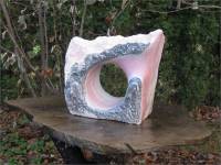

Owl of Karheen Conglomerate from Alaska, Gary McWilliams
Pink Marble Sculpture from Alaska, by Gary McWilliams
Large yellow snail fossil in Aphrodite Marble from Alaska, Gary McWilliams
- Gary McWilliams, Marble Carver, in Craig, Alaska, is the subject of the article, “Carving beauty: Craig man transforms rare Southeast Alaska rocks into art,” by Elizabeth Bluemink, Juneau Empire, Web posted June 29, 2006. (The link to this article is no longer available.)
<http://www.juneauempire.com/entertainment/stories/062906/art_20060629006.shtml >According to this article, Gary McWilliams is a sculptor and owner of Stone Arts of Alaska in Craig, Alaska. He prospects all over Alaska searching for marble to use in his sculptures including marble the Aphrodite marble deposit that he located in 1994 and named.
- Gary McWilliams – “Aphrodite marble mine
beautifies Southeast: the search for this colorful rock brought
entrepreneur Gary McWilliams into business,” in
Alaska Business Monthly, November, 2002, by Kent L. Colby,
on findarticles.com. (This article includes information on the
history of early Alaska marble.) (The link to this article
is no longer available.)
<http://findarticles.com/p/articles/mi_hb5261/is_/ai_n28955942> - Judd Mullady, Marble Carver, of Haines, Alaska, is the subject of the article “Working with marble, rolling with changes,” by Tom Morphet, in the Chilkat Valley News, Vol. XXXVIII, No. 49, December 11, 2008.
According to this article, sculptor Judd Mullady has carved marble gravestones for families in Haines and Juneau. He uses local Haines marble which varies from “white, pink or green in color.”
According to the Alaska State Capitol brochure (in PDF format), Juddy Mullady created the sculpture “Two Alaskan Otters” from marble quarried from Haines. The sculpture is located in the ground floor lobby of the Alaska State Capitol building.


Commercial use of material within this site is strictly prohibited. It is not to be captured, reworked, and placed inside another web site ©. All rights reserved. Peggy B. and George (Pat) Perazzo.