
1891 - Missouri Building Stones
Excerpts From
“Notes on The Clays and Building Stones of Certain Western Central Counties
Tributary to Kansas City”
By G. E. Ladd, Assistant Geologist
In Bulletin No. 5, Geological Survey of Missouri,
Jefferson City, July 1891, pp. 46-86.
(Please note: The “Clays” and “Bricks” sections will not be presented here. This book is available for reading and downloading to your computer in the Google Book Search - Full View section)
Contents.
Clays - 50
General Remarks - 50
Quaternary Clays - 50
Coal Measure Clays - 51
Illustrations.
Plate V. Fig. 1. View of the Weston Lime Quarry at Kansas City - 72
Plate V. Fig. 2. View of a Bluff Quarry at Kansas City - 72
Prefatory Remarks.
“These notes on the clays and structural materials of certain western-central counties are, in one sense, complemental to the report on the clay and stone industries of St. Louis, published in Bulletin No. 3, inasmuch as the two articles together describe the industries of, and the raw products most available to the two distinctively large cities of the State.
“A summary of the statistics of production contained in the tables of this article gives the following figures for the amounts of the various products during the year 1890:
Structural brick - 88, 380, 000
Gallons of pottery - 955, 000
Tons of clay manufactured into sewer pipe - 65, 000
Feet of drain tile - 65, 000
Feet of chimney flues - 3, 000
Stone quarried.
Lin. ft. of curbing - 58, 639
Perch of rubble and footing - 109, 315
Yards of rip-rap and macadam - 28, 519
Feet of range or cut stone - 13, 350
And about 50 car loads of curbing and 25, 000 square feet of flagging, curbing and building stone.
“Had Kansas City, during the past year, been in a condition of normal activity, the amount of these products would undoubtedly be much greater; but the depression in business affairs which has prevailed in this city has necessarily had its influence upon the industries here treated of. With the renewal of vigorous life, which must undoubtedly come to a place so advantageously located as is Kansas City, in the midst of a country rich in natural resources, these industries will undoubtedly assume much greater proportions within a few years.
“The stage of progress of the work of the Survey, on the clays and structural materials of the State, renders it probable that no other bulletin article on these subjects will appear. It is at present the plan to push the field and laboratory work incidental to these investigations as rapidly as possible and our next publication embracing such matter probably be of the nature of a final report upon these materials for the whole State. The results of the large amount of analytical and experimental work which has been in progress upon the clays will be embodied in such a report, together with full descriptions of all important occurrences and information upon the value and adaptabilities of the different clays. We can unreservedly predict that this volume will be an invaluable one to all interested in the clay deposits and the clay industries of the State.
“For assistance in prosecuting this work in these western counties, the Survey is under especial obligations to Dr. J. H. Britts, of Clinton, who has always unhesitatingly given his time and attention to assisting in promoting the work of the Survey when in his neighborhood, to Mr. E. T. Keim, to Mr. E. Butts and to Mr. Edwin Walters, of Kansas City, who have generously contributed information and tendered their support to the work of the Survey on many occasions.
Arthur Winslow, State geologist.
Notes on The Clays and Building Stones of Certain Western Central Counties Tributary to Kansas City Including Bates, Cass, Henry, Jackson, Johnson, Lafayette and Vernon Counties
By G. E. Ladd, Assistant Geologist.
(Please note: One the stone quarry sections will be presented here, although general sections that include stone and other resources will be included. This book is available for reading and downloading to your computer in the Google Book Search - Full View section)
Assistance.
The following brief notes are offered as a descriptive outline of the clay and stone resources of the area discussed, and of their dependent industries. A more specific report in the future, will include the results of the analyses and tests of these occurrences of clay and stone which seem worthy of complete examination. The writer is indebted to Mr. Elston Lonsdale and to Mr. Leo Gluck for aid in the field, and to Mr. E. Butts, City Engineer of Kansas City, for a valuable statistical table of the stone quarries of that place.
General Geology.
Formations represented.
“In the area under consideration the geological formations occurring represent the Quaternary, Coal Measure and Lower Carboniferous periods.
Quaternary.
“The Quaternary deposits are represented by Loess, alluvium drift, soils and residuary clays. The drift is but slightly developed. The other forms occur abundantly.
Coal Measures.
Coal Measures wide spread.
Fire clays and sandstone in lower beds.
“The Coal Measures occupy nearly the entire area. They have a general westerly dip, and expose in succession, according to the determinations of the earlier geological surveys of the State, beds of the Lower, Middle and Upper Coal Measures. They consist essentially of alternations of limestones, sandstones, shales, clays and coal. The limestones are found mostly in the upper part of the Coal Measures, and are rare among the lower beds; here, however, coal deposits argillaceous shales, sandstones and fire clays are most highly developed. The beds in places are somewhat flexed, and probably, in a few localities, are faulted.
Lower Carboniferous.
“In the south-eastern border of our area the Lower Carboniferous rocks reach the surface, and are represented by the limestones of the Keokuk and Burlington formations.
(“The Clays” section will not be presented here, pp. 50-52. This book is available for reading and downloading to your computer in the Google Book Search - Full View section)
Building Stones.
General Remarks.
Building Stones from Coal Measures and Lower Carb. rock.
“Two sources of supply of building stone material may be recognized geologically within the area described, namely, the Coal Measures and Lower Carboniferous. The outcrops of the limestones of the latter formation are limited in number, and are at present comparatively inaccessible. They are capable, however, of furnishing an abundance of good building material. The Coal Measures supply both limestones and sandstones.
Limestones.
Coal Measure furnish limestones.
“In addition to the isolated limestones of the Lower Carboniferous outcrops, there are a number of beds in the Coal Measures capable of supplying limestone for a variety of purposes. These beds vary much in thickness and in the quality of stone. The workable beds are practically confined to the Upper Coal Measures, and geographically, to the central and north-western part of our area. The material which they furnish is in places adapted for the production of dimension stone, but more generally for macadam, flagging, foundations and lime making. Some beds yield, in large blocks, stone which can be handsomely and easily dressed. One bed furnishes a marble which takes an excellent polish, has a dark bluish drab color, and is handsomely variegated with the outlines of many fossils.
Sandstones.
Coal Measure sandstones of variable character.
“The sandstones of this area are confined, probably, to the Lower and Middle Coal Measures. They vary in thickness from a few inches to ninety feet or more. They are usually micaceous, and not infrequently highly calcareous. In many places they are intermixed with bituminous matter. They occur, sometimes apparently massive, again in thin slabs suitable for sidewalk flagging, and oftentimes crossbedded, or with the successive beds varying very much in character. Many of the beds furnish a good quality of dimension stone, which is durable, strong and easily dressed. Some are suitable for the manufacture of good grindstones.
“As the sandstone usually vary rapidly in character in the same bed, conclusions as to the value of the stone as a whole for quarrying, from observations at any one place, are unreliable. A bed which appears locally to be of suitable thickness and character is likely in a very short distance to occur separated into several beds, or to have such flaws in it as to necessitate a great waste in the selection of material. The flaws occur, in different localities, as joint planes, concretionary masses of iron ore, discolorations, crystals of iron pyrites, loose uncemented masses of sand, bitumen and seams of coal.”
Descriptive Notes By Counties.
Bates County.
Only Coal Measure beds occur in Bates Co.
“With the exception of a few Quaternary deposits the exposed beds in Bates county belong entirely to the Coal Measures, the Lower, Middle and Upper divisions being represented.1
(1 Page 53 footnote: They have been described at some length by Professor G. C. Broadhead, in a report on Bates county published in the Report of the Missouri Geological Survey, 1873-74.)
“The southern half of the county is occupied, almost wholly, by the Lower Coal Measures.
(“The Clays and the Clay Industries, ” “The Brick Manufacturers, ” and “The Drain Tile Works” sections for Bates County, Missouri, will not be presented here, pp. 54-55. This book is available for reading and downloading to your computer in the Google Book Search - Full View section)
The Building Stones and The Stone Industry (of Bates County, Missouri).
Coal Measure sandstones.
“The Coal Measures furnish an abundance of building material suitable for the local demands. The best quality is found among the sandstones. A stone supposed to be the equivalent of the Warrensburg sandstone occurs in a number of localities, where it may be quarried to advantage.
“Limestones are quarried, locally, in a small way, for building purposes. The sandstones are quarried for building and dimension stones, and, at one locality, about a mile east of Butler, a white sandstone is quarried by the firm of Miller & Son, in a small way, to be used in the production of fire brick.
Section south of Butler.
“Day. T. J.: - Mr. Day has a quarry in sandstone, on the bluff of a creek about three and one-half miles south of Butler. The section at this quarry is as follows: -
1. Soil and decomposing sandstone - 5 feet.
2. Sandstone, cross-bedded, containing numerous streaks of bituminous matter. (These seem to be the remains of some bed of coal destroyed at no great distance, and re-deposited here with the sand.) - 6 feet.
3. Sandstone, a solid, unbroken bed, varying, from the top downwards, from a light grey to a dark bluish color. It sometimes contains little cavities, partially filled with a reddish substance, which probably contains organic remains - 13 feet.
Stone soft, but does not wash.
“Stone is quarried by handpicks. It is very soft and friable when quarried, and can be crumbled between the fingers, but it soon hardens on exposure to the air. It dresses easily, and will admit of considerable carving. It is claimed that it does not wash, and that it resists weathering influences very well. Its greatest defect is that it contains, occasionally, concretions or crystals of iron ore which oxidize and stain the stone, and which spoil the chisels of the workmen who dress it. This sandstone is used for bases to monuments and tombstones, and for building purposes.”
Cass County.
Coal Measure rocks.
“Cass county contains geologically Quaternary deposits, and the Upper and Middle Coal Measures. Possibly the Lower Coal Measures may be found in the valleys of the south-eastern part of the county. The Upper Coal Measures occupy the greater part of the county, including most of the western and northern portions.
(“The Clays and the Clay Industries” and “The Brick Manufacturers” sections for Cass County, Missouri, will not be presented here, pp. 56-57. This book is available for reading and downloading to your computer in the Google Book Search - Full View section)
The Building stones and The Stone Industries (of Cass County, Missouri).
Limestones are available.
“The building stone of this county is practically confined to the limestones. Of these there are a number of valuable beds2 in the Upper Coal Measures, which are represented in the general section made by Professor Broadhead, by Nos. 74, 78, 79, 83 and 84. Stone is obtainable from these beds suitable for ordinary purposes, and for dimension work. Some of the beds furnish a marble which is easily polished, and is of a handsome color.
(2 Page 57 footnote: For a description of these beds see Professor Broadheads report Geological Survey, Mo., 1872, Part 2, pp. 141-2. Professor Broadhead discusses, also, their economic value as a source of supply of building material.)
“The limestones have been quarried, on a small scale, at a number of localities in the county, notably in the vicinity of Pleasant Hill and Harrisonville.”
Henry County.
Formations represented.
“Henry county contains geologically Quaternary deposits, Lower and Middle Coal Measures, and Lower Carboniferous Limestone.
The Quaternary deposits.
“The Quaternary deposits consist of occasional thin sheets of gravel and sand, of soil, residuary clays, alluvium and Loess. The two latter occur abundantly along the valleys, and what seems to be a form of Loess covers wide areas of the prairie with a thickness varying from five to twenty feet.
The Coal Measures.
The Middle Measures are confined to the north-western part, while the Lower Measures occupy the great central area. The Lower Measures are here, as elsewhere, the most important, economically. They are exposed to better advantage in Henry county than anywhere else in the area under consideration, but have also suffered more disturbance. They furnish various grades of clays, clay shales, coal, and a good sandstone for building purposes.”
(“The Clay Deposits and the Clay Industries, ” “The Brick Manufacturers, ” and the “Sewer Pipe Works” sections for Henry County, Missouri, will not be presented here, pp. 58-66. This book is available for reading and downloading to your computer in the Google Book Search - Full View section)
The Building Stones and The Stone Industries (of Henry County, Missouri).
Coal Measure sandstones chiefly used.
“Lower Carboniferous limestones occur in the south-eastern part of the county, being represented by beds of the Burlington group. The beds here will furnish the best of material for lime making and building stone, but at present (circa 1891) they are comparatively inaccessible. The Coal Measures of Henry county furnish some excellent sandstone, but practically no limestones for building purposes. The sandstones are widely distributed. Beds in the vicinity of Clinton, and those mentioned in the sections at Gilkersons Ford and Jacksons Mill, given above, have proven good building material. They are durable and easily worked. Large blocks are obtainable in some localities. The best beds occur near the surface, and need but little stripping.
“The stone industries have been little developed, only such operations having been entered into as was due to local demands, there being no material suitable for the shipping trade. No. quarries of sufficient importance to need special description are being worked at present (circa 1891).”
Jackson County.
Formations represented.
“In Jackson county are represented the Quaternary deposits, of which the Loess is the most important, and the Upper and Middle Coal Measures. The Upper Coal Measures occupy nearly the whole area of the county.
(“The Clays and the Clay Industries, ” “The Brick Manufacturers, ” “The Potteries, ” and “The Sewer Pipe Works” sections for Jackson County, Missouri, will not be presented here, pp. 67-71. This book is available for reading and downloading to your computer in the Google Book Search - Full View section)
The Building Stones and the Stone Industry (of Jackson County, Missouri).
Stone suitable for common purposes.
“The supply of building stone is confined to the layers of rocks included between Nos. 71 and 99 of Prof. Broadheads general section. These layers vary from one foot to thirty feet in thickness; they furnish a material suitable, only in most cases, for common purposes. Some of the layers, however, are occasionally thick bedded, and permit the quarrying of a good dimension stone, in large sized blocks.
Quarries similar in character.
Nearly all of the active quarries in the county are in Kansas City, were (sic) they are operated under the stimulus of the large local demand. These quarries are so similar in character as to need no individual mention, beyond the facts which appear in the statistical table at the end of this article. They are all, practically, openings in the sides of the bluffs and hills, and they are rarely worked to any considerable depth, owing to the rapidly increasing amount of stripping as the hill or bluff is penetrated.
Plate V.
“On the opposite page (below) are two illustrations of typical quarries in the Upper Coal Measures, at Kansas City. That of the Weston quarry shows the thin, irregular beds of stratum No. 98, and a thick, typical bluff stripping of Loess. That of the north bluff quarry illustrates well the occurrence of the limestones where interbedded with shale.”
| Plate V. Fig. 1. A view of the Weston Lime quarry. Illustrating a Kansas City quarry with Loess stripping. |  |
| Plate V. Fig. 2. A view of a north bluff quarry at Kansas City. Illustrating a bluff quarry with the limestone interbedded with shale. | 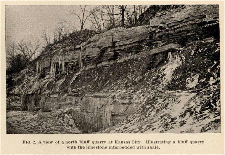 |
Johnson County.
Formations represented.
“The formations of Johnson county include the Quaternary deposits, and the Lower and Middle Coal Measures. The Quaternary deposits consist of the usual Loess, soil, alluvium and residuary clays. The Lower Coal Measures, generally speaking, occupy the eastern part of the county, and the Middle Coal Measures the central and western parts.
(“The Clays and the Clay Industry, ” “The Brick Manufacturers, ” and “The Drain Tile Works” sections for Johnson County, Missouri, will not be presented here, pp. 72-73. This book is available for reading and downloading to your computer in the Google Book Search - Full View section)
The Building Stones and The Stone Industry (of Johnson County, Missouri).
The Warrensburg sandstone.
“The building stones of Johnson county having a commercial value are sandstones. These are widely developed, and are known as the Warrensburg and the Carbon Hill sandstones. The former is, by far, the best known sandstone in the State, and it has enjoyed a wide sale for years, being used in many large public and private buildings. The demand for it has, however, fallen off lately. This sandstone formation is a hundred feet or more thick. It varies from gray to brown, but, as used, is generally of a gray color, which is of uniform, handsome appearance. It is often calcareous, highly micaceous, and quite friable. It contains, frequently, large nodular masses of siliceous iron ore, and pockets of bitumen, and of argillaceous matter.
The Carbon Hill sandstone.
“The Carbon Hills sandstone occurs in the Lower Coal Measures. It is from five to eight feet in thickness, and is well marked throughout the county. Its color is buff and brown. It is soft and easily worked. It has been quarried only for local uses, such as foundations, bridge abutments and so forth.
The quarry dimensions.
“Bruce Quarry Company: - This company works two sandstone quarries in close proximity to each other, just north of Warrensburg. Both quarries are sunken. One is thirty-five feet deep, two hundred and fifty feet long, and one hundred and thirty-five feet wide; the other is fifty feet deep, five hundred and twenty-five feet long, and one hundred and thirty-five feet wide. The stripping varies from six to eighteen feet in thickness, and consists of soil and decomposing sandstone.
The stone used.
“The stone has frequent flaws, and consequently a great deal of waste material is handled. Its color varies from a light to a brownish gray. It is micaceous and calcareous, and is very soft when quarried, but hardens somewhat on exposure to the air. It varies in the quality of durability, in different parts of the quarry, and some of it appears to be inferior in this respect. Its refractory qualities are excellent. The product consists wholly of dimension stone and blocks of any desirable size are obtainable.
The Plant.
“The plant consists of one sixteen horse power engine, and a twenty-five horse power boiler, one steam pump, four channeling machines, wagons, sheds, office, blacksmith shop, three steam derricks, and one horse power derrick.
“Pickel, Jacob: - Mr. Pickel has a quarry in the vicinity of the Bruce quarries, which has been worked for twenty-two years. It is connected with the Missouri Pacific railway by a switch, two and one half miles long.
Plant and Product.
“The quarry is about sixty feet deep, and exposes from fifteen hundred to two thousand feet of rock face. The character of the stone is similar to that described in the Bruce quarry. The product consists of both sawed and rough dimension stone. The plant includes three channeling machines, four steam engines (having a total of one hundred and fifty horse power), one steam traveler, seven steam derricks, one steam pump, wagons, platform cars, sheds, blacksmith shop and office. Since the quarry was opened about one hundred thousand cubic feet of dimension stone have been produced. One fourth of this was sawed, the rest sold in the rough.”
Lafayette County.
Formation represented.
“In Lafayette county are represented the Quaternary and Coal Measure formations. The Quaternary deposits are similar to those in Jackson county. The Coal Measures are represented chiefly by the middle beds which occupy nearly the whole are of the county. A few patches of the Upper Coal Measures occur in the Western part of the county.”
(“The Clays and the Clay Industries” and “The Brick Manufacturers” sections for Lafayette County, Missouri, will not be presented here, pp. 75-77. This book is available for reading and downloading to your computer in the Google Book Search - Full View section)
The Building Stones and The Stone Industry (of Lafayette County, Missouri).
Sandstones chiefly worked.
“Both limestones and sandstones occur. The sandstones are quarried systematically, but the limestones are worked in a small way, locally, to be used for foundations. The beds of limestone which are so worked come from immediately above, or below, the Lexington Coal bed.
“Davis, D. H.: - Mr. Davis has a sandstone quarry situated in township 51 N. 24 W., section 18, east half of the northwest quarter.
Quarry dimensions. - Stone soft and brownish.
“The quarry has a face about one hundred and forty-five feet long, and exposes, vertically, about twelve feet of sandstone. The bed is cut by vertical joint planes which are about five feet apart. Its maximum thickness is twelve feet, but it is usually parted by a bedding plane so that the largest block ordinarily obtainable is about five feet thick. Blocks of stone five by five by four and a half feet in size are readily obtainable, and one of these dimensions may be increased, sometimes, to ten feet. The sandstone when dry has a yellow color. When freshly quarried it is brownish, very soft, and easily worked. There are numerous ferruginous streaks running through the bed.
Product.
“About four thousand five hundred cubic yards of stone have been removed from the quarry. Of this amount, about one thousand yards went to waste. One half of the remainder was used locally, and the other half was shipped away by rail. The following is the section made at the quarry, in descending series: -
Sections.
1. Slop of stripping.
2. Limestone, blue - 1 foot, 3 inches.
3. Shaly sandstone - 1 foot, 3 inches.
4. Sandstone - 12 feet.
5. Shale, dark colored, sandy - 20+ feet.
Quarry material and dimensions.
“Railroad Sandstone Quarry. - This quarry is situated on the J.C. & B. branch of the Missouri Pacific railway, township 51, north range 26 west, Section 23, middle of the north-west quarter of the south-east quarter. The quarry is twelve hundred feet long, but the available face is only seven hundred and fifty feet long. The stone is irregularly stained with iron, is soft and easily crumbled. The sandstone is about twenty feet thick, but the lower ten feet, only, is workable. This lower part is divided into three layers of equal thickness, which are strongly cross-bedded in places.
“The following is the section obtained here, in descending series: -
Section.
1. Soil and clay - 10 feet.
2. Shale - 10 feet.
3. Shaly sandstone - 10 feet.
4. Sandstone, the workable part - 10 feet.”
Vernon County.
Formations represented.
“Vernon county is represented, geologically, by Quaternary deposits, Lower Coal Measures, and Lower Carboniferous Limestone. The Quaternary deposits are everywhere present and are similar to those of the adjoining counties. The Lower Coal Measures occupy nearly the entire area of the county. Members of the Keokuk group of the Lower Carboniferous Limestones, reach the surface in the south-eastern part of the county and in several isolated places.
(“The Clays and the Clay Industries, ” “The Brick Manufacturers, ” “Potteries” sections for Vernon County, Missouri, will not be presented here, pp. 78-80. This book is available for reading and downloading to your computer in the Google Book Search - Full View section)
The Building Stones and the Stone Industry (of Vernon County, Missouri).
Coal Measure sandstones worked.
“The building stones of Vernon county occur as sandstones and limestones. There are occasional workable beds of sandstone in the Lower Coal Measures, and there is an extensive and very thick sandstone which is worked at several localities in a small way. The Keokuk limestone will furnish a good building stone, and material for lime-making. The out crops are so far from railroads, however, that no regularly worked quarry has been opened in them, with the exception of one on the Osage river, west of Shell City, where the stone is burned to lime.
The Stone Quarries.
Quarry dimensions, material, and plant.
“Anderson, Gustave: - Mr. Anderson has a sandstone quarry at Nevada, which is worked in a small way, as an open cut in a hill side. The formation seems to be the same as that at Warrensburg, but the quality of the stone is, perhaps, better, there being fewer flaws in it. The stone is fine-grained, rather loosely cemented, light gray and brown in color, and can be quarried in large sized blocks. The quarry has an open face eighteen feet high and fifty feet long. It is worked by hand drilling and blasting. In 1890 about five thousand feet of building stone were quarried.
Quarry dimensions, Material, and plant.
“Gilfillan Stone Co.: - This firm has a sandstone quarry in Deerfield township and is connected with the Minden branch of the Missouri Pacific railway, by a switch, one mile and a quarter long. It was opened in 1885. The product consists of dimension stone and flagging. The quarry is a sunken one, forty feet deep, two hundred feet long, and sixty-five feet wide. The stone resembles the Warrensburg stone and possibly belongs to the same formation. The lower layer varies from twelve to sixteen feet in thickness and furnishes the best quality of stone. The upper layers are not desirable. From the action of the weather large scales of stone fall from exposes surfaces.
Imperfections of the stone.
“The stone is frequently cross-bedded and, in places, there are large nodules of iron pyrites, pockets of decayed vegetable and earthy matter, and pockets of coal, which accompanied the sand at the time of the latters deposition.
“It is necessary to handle a large amount of waste material in order to quarry much dimension stone here. The largest block ever quarried was fourteen by four feet, in dimensions.
The plant.
“The plant consists of one ten horse power engine, one derrick, one gang saw, one channeling machine, one steam drill, one steam pump, blacksmith shop and sheds.
“In 1890 about fifty cars of stone were shipped.
The product.
“Powell, Mitchell & Bowker: - This firm has a sandstone quarry situated thirteen miles east of Nevada. It was first worked in 1890. The layers of stone vary from two to twelve inches in thickness, and the blocks may be obtained of any desired size in the other dimensions. The stone is colored white and bluish and is very hard. The product consists of curbing, flagging and building stone. In 1890 twenty-five thousand square feet of material was produced.”
Concluding Remarks.
“A general survey of the area discussed here shows it to be well supplied with clay and stone building materials, suitable for most of the local needs.
The future of the stone industry.
The building stones, however, are, with few exceptions, inferior for cut stone work, or are, at present inaccessible (circa 1891). It is improbable that they will ever form the basis of an extensive industry. Both the conditions of location and the qualities of the stone, will prevent this. For a stone of much commercial value, only the sandstones can be looked to, and the most promising of these, the so-called Micaceous or Warrensburg formation, appears to be too uncertain in character, and too susceptible to weathering influences for any very general development. The best beds seen in reference both to quality and to conditions of occurrence, are in the vicinities of Nevada and Butler.
The future of the clay industry.
“The clays of economic value are wide spread, almost omni-present, and of a quality and mode of occurrence, that will permit a great development of the dependent industries. They are specially adapted for the manufacture of terra cotta, building brick of all kinds, pottery, sewer-pipe, and paving brick.
Statistics of Production.
Productions of 1889 and 1890.
“The following tables give in some detail the figures of production of stone quarries and clay works.”
| Clays and Building Stones. Statistical Table of Stone Quarries. For The Year 1890. |  |
| Clays and Building Stones. Statistical Table of Stone Quarries. For The Year 1890. (Continued) |  |
Statistical Table of Clay Industries. |
 |
| Statistical Table of Clay Industries. Pottery, Tile and Sewer Pipe. |  |
Commercial use of material within this site is strictly prohibited. It is not to be captured, reworked, and placed inside another web site ©. All rights reserved. Peggy B. and George (Pat) Perazzo.