
Excerpts from
“The Clay, Stone, Lime and Sand Industries of St. Louis City and County”*
By G. E. Ladd, Assistant Geologist
In Geological Survey of Missouri, Bulletin No. 3, Supplement
December 1890.
(* Please Note: All of the material on the stone and lime industries will be presented here, although only portions of the material on the clay and sand industries will not. The individual stone quarries listed in this document will also be listed in the St. Louis, Missouri, quarry section of the web site. Peggy B. Perazzo)
Introduction
“This paper is a partial result of work done by the author during the past spring and summer in St. Louis and vicinity, in pursuance of the investigation of the clays and building stones of Missouri.
“The materials discussed are of much importance to a great city, where, if they exist, they are sure to be extensively developed. With most of the ordinary structural materials needed by a city, St. Louis is, happily, well provided, and in the following pages the writer attempts to convey a fair impression of the nature and extent of the industries in the city and county which produce these materials; and also of the nature and extent of their sources of supply.
Objects of maps.
“The sketch maps used have two purposes. One of these is to show in a rough way the distribution of the different geological formations, to which, in the text, the different kinds of geological formations, to which, in the text, the different kinds or grades of structural materials are referred. The other purpose is to show the location of all quarries, clay mines, brick and other works.
“Two conventional sections are printed to show the reader at a glance the probable thickness, and the relative positions of the different geological formations.
Assistance.
“A great part of the credit for whatever of value this paper may have is due to those who have lent their assistance to the author. Especially is he indebted to Mr. Elston H. Lonsdale for efficient aid in the field; to Mr. Amos E. Woodward for the analysis of many samples of limestone and clay, and to Mr. Leo Gluck for the drawing of maps and sections. A personal debt is also due Mr. J. D. Robertson and Prof. H. A. Wheeler for either valuable suggestions or aid in the field.
“The report of Mr. B. F. Shumard on the Geology of St. Louis county, in 1855, has been an invaluable aid. The map showing the distribution of formations is mainly from Mr. Shumard’s map, modified so much as the hurried observations of the author would warrant.
A List of Clay Works and Stone Quarries in St. Louis City.
Sketch Map showing the location of the Quarries, Clay Works and Clay Pits in the City of St. Louis.


A List of The Stone Quarries and Clay and Lime Works in St. Louis County.
The locations of these quarries and works on the County Map are indicated by the numbers in the columns.
Proprietor - Map Number.
| Andrew, --- - 68. | Lauritzen, Jas. - 56. |
| Boem, Fritz - 50. | Madden. Thos. - 58. |
| Bessen & Sons - 64 | Munsen, --- - 52. |
| Crystal Spring Quarry and Lime Co. - 47 | Pope, Andrew - 59. |
| Doering, J. H. - 51. | Schwenn, John - 66. |
| Dore & Wallace - 67. | Selfert, Henry - 60. |
| Eureka Quarry Co. - 57. | Shore’s Quarry Co. - 54. |
| Exner, John. - 62. | Steffen, John C. - 61. |
| Fabrick, P. & Marshall - 53. | Theby, Michael - 48. |
| Glendale Quarry. Co. - 55. | Watson Construction Co. - 65. |
| Jefferson Barracks - 63. | Zeiss, Henry & Mrs. - 49. |
Clay Works.
| Proprietor - Map Number. |
| Jameson, William - 124. |
Lime Works.
| Proprietor - Map Number. |
| Dorenheim, Herbert - 76. |
| Glencoe Lime & Cement Co. - 70 to 72. |
| Goetz, Chas. W. - 73 and 75. |
| Thorn & Hunkins - 74. |
| A Reference Map of St. Louis County, Showing the Location of the Quarries, Clay Pits and Works and the Distribution of the Geological Formations. Reproduced from Shumard’s Map, with Modifications by G. E. Ladd. |  |
General Geology.
Boundaries of the area.
“St. Louis city and county are bounded on the north by the Missouri river, on the east by the Mississippi river, on the south by the Meramec river and a part of Jefferson county, and on the west by Franklin county.
Determination of horizons.
“The geology of this area was described in a general way by B. F. Shumard, during the Swallow survey, in 1854. No detailed study has followed his work, and, in the absence of such a study, the writer has adopted, for the purpose of reference in this paper, Mr. Shumard’s determinations of horizons. With reference to the distribution and extent of some of the formations, modifications have, however been made.
The section.
“A section of most of the local formations was constructed by Professor G. C. Broadhead, in 1875, from the borings and accompanying records of the St. Louis Insane Asylum well, which was sunk to a depth of nearly four thousand feet. This section does not include the Middle Coal Measures nor the Ferruginous Sandstone of the Chester Group. It includes, however, many of the older rocks which do not reach the surface in either the city or county.
“The formations are all of sedimentary origin. They represent a wide range of time and a considerable variety of conditions of deposition. They have nearly all been somewhat disturbed from their original positions.
“On the accompanying map their distribution is provisionally shown. The quaternary deposits, which are not outlined as a whole, cover nearly the entire area.
| General Geological Section of the Formation in St. Louis City and County. |  |
The gap in the section.
“The general section is compiled from Shumard’s and Broadhead’s publications, and the author’s observations. It includes only such formations as reach the surface within the described area. By reference to this section it will be seen that three grand divisions of time have been recognized here, viz., the Quaternary, Carboniferous and Silurian. Between and within these divisions great thicknesses of formations belonging to the general section of the State are without representation. There is a clear gap in the section, from the Quarternary deposits to the Middle Coal measures, a second from the Chouteau to the Trenton Limestone, and a third from the Trenton to the first Magnesian Limestone.
Disturbances.
“The disturbances which are referred to above are manifested in the formations below the Coal Measures by a distinct dip in a northeasterly direction, gentle undulations, rather sharp anticlinal and synclinal folds, and occasional faults. The Coal Measures have been slightly flexed. The Quarternary deposits are undisturbed, save by erosive influences.
| General Cross Section Through St. Louis County, Modified from Shumard’s. Looking north. |  |
(Page 15 footnote: Topographic sheets of most of the area discussed in this paper have been already completed by the United States Geological Survey, and they will form the basis for detailed geological work in the future. Of much importance here are the questions of distribution, of relative position, and of the characteristics of the materials. The great industries which have arisen to handle these materials owe their origin largely to some accident of discovery, and they have grown in spite of the burden of much costly experiment. They have lacked always a local standard to which to refer their products, a working knowledge of the extent of their deposits and of their persistence in character.)
The Clay Industry.*
Sources of clay.
“Geological speaking, St. Louis has three local sources of clay. These are the Coal Measures, the Quarternary deposits, and the residuary product of decomposing limestones.”
(* Please note that the rest of the section on the clay industry in the St. Louis City and County area will not be presented here, although the photograph and the tables from the section will be presented below.)
| Entrance to the Fire Clay Mine of the Laclede Sewer Pipe company, showing the sandstone roof and the beds of pipe clay above it. |  |
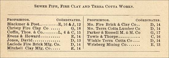
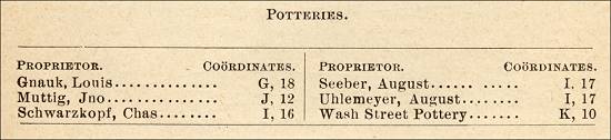
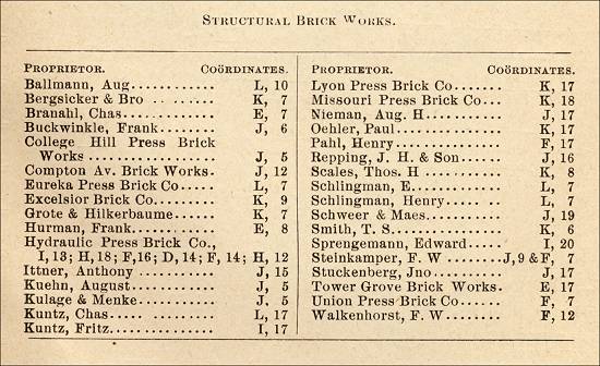
| Table of Producers of Pot Clay, Crude Clay, Sewer Pipes, Clay Refractory Materials, &c., in The City and County of St. Louis. | 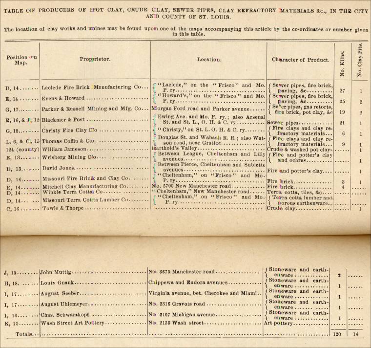 |
| Statistics of the industries mentioned in the Above Table for the Year 1889. | 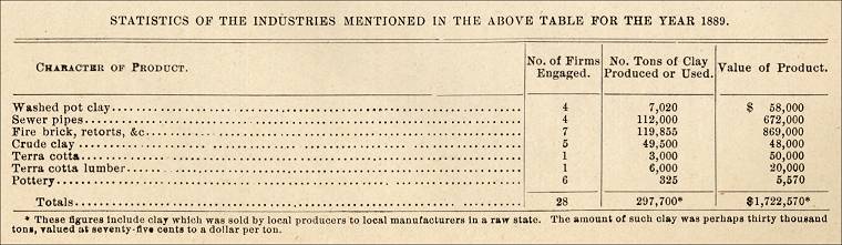 |
Commercial use of material within this site is strictly prohibited. It is not to be captured, reworked, and placed inside another web site ©. All rights reserved. Peggy B. and George (Pat) Perazzo.