
Structures and Monuments in Which
California Stone was Used
Finished Product from California Stone in California (Continued)
- San Jose and nearby Towns, Santa Clara County, California -
Buildings of Sandstone from the Graystone Sandstone Quarries (From The
Structural and Industrial Materials of California, Bulletin No.
38, California, State Mining Bureau, San Francisco, California,
1906.)
The buff-colored sandstone from the Graystone Quarries was used "...in San Jose and nearby towns for many years."
- San Jose, Santa Clara County, California – Buildings in San Jose (The following information is from “Projects Utilizing Rocklin Granite,” compiled by members of the Rocklin Historical Society from various sources, 2011.)
“1906 Buildings at Tonopah, Nevada; Oakland, San Jose, Fresno”
- San Jose, Santa Clara County, California – the
Garden City Bank Building (From Report XIV of the
State Mineralogist – Mines and Mineral Resources of Portions
of California, Chapters of State Mineralogist’s Report – Biennial
Period 1913-1914, Part II. “The Counties of Colusa,
Glenn, Lake, Marin, Napa, Solano, Sonoma, Yolo,” by Walter
W. Bradley, Field Assistant (field work in October, 1913), California
State Mining Bureau, San Francisco, California, 1916, pp. 173-370.)
Sandstone quarried by the Colusa Sandstone Company Quarry east of Sites in Colusa County, California, was used in the construction of the Garden City Bank building in San Jose.
- San Jose, Santa Clara County, California - the Hall
of Justice (The following information is from the Goodrich
Quarry Plaque, presented on the E
Clampus Vitus 1850 web site.)
The Hall of Justice was constructed from buff-colored sandstone quarried from the Goodrich Sandstone Quarry in southern San Jose, Santa Clara County, California.
- San Jose, Santa Clara County, California – the Hall of Records (The following information is from “Projects Utilizing Rocklin Granite,” compiled by members of the Rocklin Historical Society from various sources, 2011.)
“1884 Hall of Records, San Jose”
- San Jose, Santa
Clara County, California - Oak Hill Memorial
Park – the 10 Crypt Private Marquez Family
Mausoleum (photographs) The following information is
from the Cold
Spring Granite web site.
According to this web site, Royal Black granite (quarried at Quebec, Canada) and Sierra White granite (quarried at Raymond in Madera County, California) were used in the construction of the Marquez Mausoleum.
- San Jose, Santa
Clara County, California – Okayama
Sister City Garden in San
Jose – the Paving Materials (The link from which the following information was obtained is no longer available.)
<http://www.sjredevelopment.org/grp/Guadalupeplan.pdf>According to the “Guadalupe River Park Conservancy, San Jose, Master Plan 2002” brochure, pp. 24, the “… reflective garden sits on the east bank of the river, between the River Park Towers and the Center for Performing Arts. Academy black granite stone using plant and paving materials native to each country to express some of the country’s identity and culture….”
- San Jose, Santa Clara County, California - the San Jose
Post Office (The following information is from the Goodrich
Quarry Plaque, presented on the E
Clampus Vitus 1850 web site.)
The San Jose Post Office was constructed from buff-colored sandstone quarried from the Goodrich Sandstone Quarry in southern San Jose, Santa Clara County, California.
- San Jose, Santa Clara County, California - St. Mary’s Church (The following information is from the Goodrich Quarry Plaque, presented on the E Clampus Vitus 1850 web site.)
St. Mary’s Church was constructed from buff-colored sandstone quarried from the Goodrich Sandstone Quarry in southern San Jose, Santa Clara County, California.
- San Luis Obispo, San Luis Obispo County, California - the Breakwater - Excerpt from the Tenth Annual Report of The State Mineralogist For The Year Ending December 1, 1890, California State Mining Bureau, Sacramento: State Printing Office, pp. 1890, pp. 570.
San Luis Obispo County, by Myron Angel, Assistant in the Field.
Los Cerritos,
“Running midway between the Santa Lucia and the coast hills is a unique line of peaks denominated ‘Los Cerritos’ by the Spanish. These are more or less isolated, separated streams or low passes crossing their course, and standing as a succession of buttes, rising from the southeast of the city of San Luis Obispo and trending northwest, terminating in Morrow Rock, a gigantic cone of trachyte in the ocean off Morro Bay, or the ‘Estero,’ as formerly called. The largest of these peaks is called ‘San Luis,’ one thousand five hundred feet in height, on the northwestern border of the city; ‘Bishop Peak,’ one thousand eight hundred feet high, and the highest of the range, ‘Romualdo,’ ‘Cerrito,’ and San Carlos.
“These are chiefly porphyritic trachyte, but bear serpentine about their bases, the smaller hills being almost exclusively of this formation. The trachyte constitutes an available building stone, although very hard chiseling, and can be quarried in as large dimensions as can be handled. The steps of the Court House of San Luis Obispo are made of this rock, and after fifteen years’ use the chisel marks of the stonecutter are not worn away. ‘Morro Rock’ being composed of this and standing in the sea, giving easy and generally safe access to vessels, is deemed exceedingly favorable for furnishing materials for the breakwater in course of construction by the National Government in the bay of San Luis Obispo (circa 1890.)”
- San Luis Obispo, San Luis Obispo County, California - Court House Steps - Excerpt from the Tenth Annual Report of The State Mineralogist For The Year Ending December 1, 1890, California State Mining Bureau, Sacramento: State Printing Office, pp. 1890, pp. 570.
San Luis Obispo County, by Myron Angel, Assistant in the Field.
Los Cerritos,
“Running midway between the Santa Lucia and the coast hills is a unique line of peaks denominated ‘Los Cerritos’ by the Spanish. These are more or less isolated, separated streams or low passes crossing their course, and standing as a succession of buttes, rising from the southeast of the city of San Luis Obispo and trending northwest, terminating in Morrow Rock, a gigantic cone of trachyte in the ocean off Morro Bay, or the ‘Estero,’ as formerly called. The largest of these peaks is called ‘San Luis,’ one thousand five hundred feet in height, on the northwestern border of the city; ‘Bishop Peak,’ one thousand eight hundred feet high, and the highest of the range, ‘Romualdo,’ ‘Cerrito,’ and San Carlos.
“These are chiefly porphyritic trachyte, but bear serpentine about their bases, the smaller hills being almost exclusively of this formation. The trachyte constitutes an available building stone, although very hard chiseling, and can be quarried in as large dimensions as can be handled. The steps of the Court House of San Luis Obispo are made of this rock, and after fifteen years’ use the chisel marks of the stonecutter are not worn away. ‘Morro Rock’ being composed of this and standing in the sea, giving easy and generally safe access to vessels, is deemed exceedingly favorable for furnishing materials for the breakwater in course of construction by the National Government in the bay of San Luis Obispo (circa 1890.)”
- San Luis Obispo, San Luis Obispo County, California - the Free Library Basement (From The Structural and Industrial Materials of California, Bulletin No. 38, California, State Mining Bureau, San Francisco, California, 1906.)
Stone from Bishop's Peak (Cerro Obispo) Quarry, the newer quarry, was used in the construction of the basement of the Free Library in San Luis Obispo.
- San Luis Obispo, San Luis Obispo County, California -
the Port Harford Breakwater (From The Structural and
Industrial Materials of California, Bulletin No. 38, California,
State Mining Bureau, San Francisco, California, 1906.)
Stone from Bishop's Peak (Cerro Obispo) Quarry "...the old quarry at the southwest corner of the butte large blocks were taken by A. A. Polhemus and the City Improvement Company of San Francisco for the Government breakwater at Port Harford."
Stone from the Mooro Rock at Morrow Bay, United States Government Reservation. Stone from this quarry was "...(u)sed by A. A. Polhemus for the breakwater at Port Harford. (See also XIIIth Report, California State Mining Bureau, p. 623.)" (From The Structural and Industrial Materials of California, Bulletin No. 38, California, State Mining Bureau, San Francisco, California, 1906.)
- San Luis Obispo, San Luis Obispo County, California - the
Presbyterian Church (From The Structural and Industrial
Materials of California, Bulletin No. 38, California, State
Mining Bureau, San Francisco, California, 1906.)
Stone from Bishop's Peak (Cerro Obispo) Quarry, the newer quarry, was used in the construction of the Presbyterian Church in San Luis Obispo.
- San
Luis Obispo, California - the San Luis Obispo Carnegie Library (photograph
and history) (today San Luis Obispo County Historical
Museum)
Part of the construction materials for the building were Los Berros Yellow Sandstone for the arch and window detailing and Bishop's Peak Granite was used for the foundation.
Free Public Library, San Luis Obispo. Local building materials were used in its construction. 
- San Luis Obispo County, California – Foundations,
Curbings, a few buildings in San Luis Obispo including one of
the Schools (From Report XV of the State Mineralogist,
Mines and Mineral Resources of Portions of California, Chapters
of State Mineralogist’s Report Biennial Period 1915-1916,
Part V. Monterey, San Benito, San Luis Obispo, Santa Barbara,
Ventura counties, California State Mining Bureau, 1919. Used with
permission, California Department of Conservation, California
Geological Survey.)
Bishop’s Peak Quarry, located in San Luis Obispo County: “…The rock, an andesite granophyre of dark gray color and subconchoidal fracture, has been used extensively for foundations and curbing, and a few buildings in San Luis Obispo, including one of the schools, are built entirely of it.” (Bibl.: Bull. 38, p. 153; U.S.G.S. Folio 101.)
- San Luis Obispo, San Luis Obispo County, California – H.
J. Griffith (Monument Business) (From Report XV of
the State Mineralogist, Mines and Mineral Resources of Portions
of California, Chapters of State Mineralogist’s Report Biennial
Period 1915-1916, Part V. Monterey, San Benito, San Luis
Obispo, Santa Barbara, Ventura counties, California State Mining
Bureau, 1919. Used with permission, California Department of Conservation,
California Geological Survey.)
“H. J. Griffith does a small business cutting stone at San Luis Obispo. For the bases of all of his monuments, where the stone does not require polishing, he uses the andesite granophyre from Bishop’s Peak. His equipment includes a gasoline engine and air hammer drill.”
- San Luis Obispo, San Luis Obispo County, California – Sunset
Monument and Building Works (From Report XV of the
State Mineralogist, Mines and Mineral Resources of Portions of
California, Chapters of State Mineralogist’s Report Biennial
Period 1915-1916, Part V. Monterey, San Benito, San Luis
Obispo, Santa Barbara, Ventura counties, California State Mining
Bureau, 1919. Used with permission, California Department of Conservation,
California Geological Survey.)
“Sunset Monument and Building Works, M. P. Rolita, proprietor, San Luis Obispo. The owner and occasionally an extra man are employed in making monuments, curbing, coping, and house foundations. The rock from Bishop’s Peak is used for all unpolished require polishing (sic), he uses the andesite granophyre from Bishop’s work is rather well liked for curbing, especially on account of the way it fractures. Hand tools are used. The rock is of two shades and degrees of hardness, because of the difference in weathering.”
- San Luis Obispo, San Luis Obispo County, California - Tuff
from the Moore Quarry used for Building Purposes (From The
Structural and Industrial Materials of California, Bulletin No.
38, California, State Mining Bureau, San Francisco, California,
1906.)."
The lower tuff (in the Moore Quarry) is much harder than the upper, has a metallic ring, and breaks in small blocks with curved faces like glass.The tuff is sawed here and used for building purposes in Arroyo Grande and San Luis Obispo, and some carloads have been shipped via Port Harford to Los Angeles."
- San
Marino, Los Angeles, California – Huntington Botanical
Garden Photo Tour – Stones Used in the Garden
and Buildings, Pasadena, California, late September, 2010. According
to our tour guide, sandstone from Arizona and granite
from Inyo County were used in portions of the Huntington Gardens.
In the Desert portion of the gardens

Near the Japanese Tea House

Looking towards the Japanese
Tea House - San Mateo, San Mateo County, California
- the Episcopal Church (from “Colusa County Sandstone
Builds Some of The World’s Most Famous Buildings,” by John
L. Morton, Colusa County Historian and Colusa County CAGenWeb
Project Coordinator.
Many fine buildings are attributed to the McGilvray sandstone quarry located at Sites, Colusa County, California, including the Episcopal Church in San Mateo.
- San Mateo, San
Mateo County, California – Linear Park in Bay Meadow Plaza (photograph) (While the link from which the following information is no longer available, the Internet Archive Wayback Machine has a link for the information from 2010.)
<http://www.coldspringgranite.com/Design-Ideas/Architectural-Project-Details/Linear-Park.aspx>According to the Cold Spring Granite web site, Academy Black granite (quarried at Clovis, Fresno County, California) and Sierra White granite (quarried at Raymond, Madera County, California) were used at Linear Park. The Academy Black granite was used for the boulders, and the Sierra White granite was used for the formal seat pads that line the pedestrian axis.
- San Pedro Harbor, Los Angeles County, California - the Breakwater
from Terminal Island to Deadman's Island, San Pedro Harbor (From The
Structural and Industrial Materials of California, Bulletin No.
38, California, State Mining Bureau, San Francisco, California,
1906.)
"On Santa Catalina Island, bluffs of trachyte come to the water's edge on the east coast, between Avalon and Empire Landing, in places to a height of 800 feet. This trachyte has been used in the old breakwater from Terminal Island to Deadman's Island, San Pedro harbor, and formerly in the Government breakwater at San Pedro, but in the latter its use was abandoned on account of the difficulty in obtaining the large blocks required, weighing over 4000 pounds...."
Los Angeles County, California – the Angel’s Gate Lighthouse – the Breakwater, presented by the town of San Pedro. (The link from which the following information was obtained is no longer available.)
<http://www.sanpedrochamber.com/champint/aglight.htm>The Angel’s Gate Lighthouse marks the entrance to the Port of Los Angeles. The breakwater at the Angel’s Gate Lighthouse “...is 9,250 feet long and contains nearly three million tons of rock, brought over from Santa Catalina Island.”
- San Quentin, Marin County, California – the San
Quentin Prison Buildings (The following information is
from The
Quarries (Alcatraz History), presented by the
Angel Island Association.)
According to this web site, the stone used to construct the San Quentin Prison buildings was quarried on the east side of Angel Island.
- San Quentin, Marin County, California – San Quentin Penitentiary – the South Cell Block (The following excerpt is from the “Brooks Island Shoreline Regional Shoreline” Brochure(pdf), presented by the East Bay Regional Park District.
“Brooks Island was used as a quarry intermittently from 1892-1938. The rock is said to have been used by San Quentin prisoners in constructing Treasure Island as well as the south cell block of San Quentin penitentiary. They Army Corps of Engineers built harbors and a breakwater to protect the Richmond Marina....”
- San Quentin, Marin County, California – San Quentin Penitentiary – the South Cell Block (The following excerpt is from the “Brooks Island Shoreline Regional Shoreline” Brochure(pdf), presented by the East Bay Regional Park District.
- San Rafael, Marin County, California – the Presbyterian
Church (From Report XIV of the State Mineralogist – Mines and Mineral Resources of Portions of California, Chapters of State Mineralogist’s Report – Biennial Period 1913-1914,
Part II. “The Counties of Colusa, Glenn, Lake, Marin, Napa, Solano, Sonoma, Yolo,” by
Walter W. Bradley, Field Assistant (field work in November, 1913),
California State Mining Bureau, San Francisco, California, 1916,
pp. 173-370.)
The Presbyterian Church in San Rafael was built from the rubble (blue metamorphic sandstone) quarried at the Hotaling Quarry located in San Rafael at the south end of Clark street prior to 1913.
- San Rafael, Marin County, California - the San Rafael Cemetery - Building Fronts and Curbings (From The Structural and Industrial Materials of California, Bulletin No. 38, California, State Mining Bureau, San Francisco, California, 1906.)
The blue-colored sandstone used for building fronts and curbings in the cemetery was taken from the Mount Tamalpais Cemetery Quarry, which is located in the upper end of the cemetery, 1 ½ miles northeast of San Rafael.
- San Ramon, Contra Costa County, California – the Gale Ranch Plaza Entrance (photographs)
According to the Cold Spring Granite web site, Academy Black Granite quarried at Clovis in Fresno County, California, was used for the entrance of the Gal Ranch Plaza.
- Santa Ana, Orange County, California - the Public Library (From The Structural and Industrial Materials of California, Bulletin No. 38, California, State Mining Bureau, San Francisco, California, 1906.)
The tawny-colored sandstone used in the construction of the Public Library building was quarried from the Chatsworth Park Quarry, which was located about 1 ½ miles west of Chatsworth, a station on the Southern Pacific Railroad.
- Santa Barbara, Santa Barbara County, California – the Breakwater at Santa Barbara (From Report XV of the State Mineralogist, Mines and Mineral Resources of Portions of California, Chapters of State Mineralogist’s Report Biennial Period 1915-1916, Part V. Monterey, San Benito, San Luis Obispo, Santa Barbara, Ventura counties, California State Mining Bureau, 1919.)
“Hogan Quarry…Beds of hard gray sandstone, a couple of hundred feet thick outcrop in Sycamore Cañon for several hundred feet. Stone from this quarry was used in building the breakwater at Santa Barbara ; also in the portals of the Bay-Shore cut-off tunnels at San Francisco, and the Sespe, Piru, and Santa Clara railroad bridges in Ventura County..Idle for past five years.
“Bibl.: R. of M. Santa Barbara Co., 1906.”
- Santa Barbara, Santa Barbara County, California - Buildings in Santa Barbara (From The Structural and Industrial Materials of California, Bulletin No. 38, California, State Mining Bureau, San Francisco, California, 1906.)
Some of the buildings in Santa Barbara were built with the sandstone from the Mission Canon quarry, located near Santa Barbara and owned by the Roman Catholic Church.
- Santa Barbara County, California – Stone Walls
in the Hills of Santa Barbara (photographs and history)
The following excerpt is from “Historic
Stonework in Santa Barbara,” presented on the Stone
Foundation web site.
Much of the stone used in building the stone walls in the hills of Santa Barbara “was obtained from local quarries and carted to job sites….”
- Santa Barbara, Santa Barbara County, California – Mission
Santa Barbara Cement (From Report XV of the State Mineralogist, Mines and Mineral Resources of Portions of California, Chapters of State Mineralogist’s Report Biennial Period 1915-1916, Part V. Monterey, San Benito, San Luis Obispo, Santa Barbara, Ventura counties, California State Mining Bureau, 1919. Used with permission, California Department of Conservation, California Geological Survey.)
“Thomas W. Moore, Santa Barbara, has an undeveloped deposit of limestone in Veronica Valley, 3 miles west of Santa Barbara. This limestone is coarsely crystalline and of a yellowish color. The owner has had numerous tests made on it and reports that it is of no commercial value. It is said, however, that the cement used in the construction of the Mission Santa Barbara was made from this limestone.
“Bibl.: Bull. 38, p. 80; R. of M. S. B. Co.”
- Santa Barbara, Santa Barbara County, California – the Post Office (The following information is from “Projects Utilizing Rocklin Granite,” compiled by members of the Rocklin Historical Society from various sources, 2011.)
“1913 Post Office, Santa Barbara”
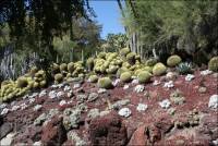
- Santa Barbara, Santa Barbara County, California – Santa Barbara Mission – Uses of Local Stone – Photo tour of stone used in the construction of the mission and on mission grounds


Towers at Santa Barbara Mission
Portion of Lavanderia at Santa Barbara Mission showing bear figure
View of the Santa Barbara tower from the cemetery
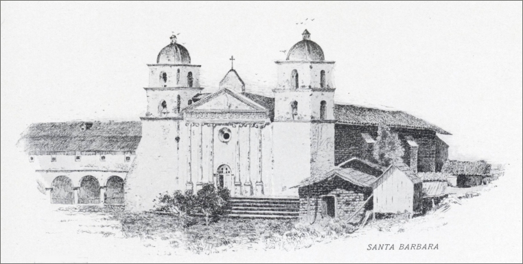
- Santa Barbara, Santa Barbara County, California – Santa Barbara Mission – “The Early Mission Establishments in California” (pdf), in Scientific American, Vol. LXIII, No. 8, August 23, 1890, pp. 118. (includes engravings of Santa Barbara Mission, Mission Santa Inez, and Mission San Luis Obispo)


Santa Barbara Mission - Front View (1890 engraving)
Santa Barbara Mission - Perspective View (1890 engraving)
- Santa Barbara, Santa Barbara County, California – Santa Barbara Mission circa 1899
You can read more about and view sketches of the California missions circa 1899 in The Missions of California (pdf), by Eugene Leslie Smyth, Chicago: Alexander Belford & Co., 1899.


Santa Barbara Mission
(sketch circa 1899)Mission Garden at Santa Barbara
(1899) - Santa Barbara, Santa Barbara County, California - Santa Barbara Cemetery/Monument Stones (From The Structural and Industrial Materials of California, Bulletin No. 38, California, State Mining Bureau, San Francisco, California, 1906.)
The Santa Barbara Marble Works quarried the blue stone in limited quantities for monuments near Gaviota Pass.
- Santa Barbara, Santa Barbara County, California – the Stevens Building (From Report XV of the State Mineralogist, Mines and Mineral Resources of Portions of California, Chapters of State Mineralogist’s Report Biennial Period 1915-1916, Part VI. San Bernardino County and Tulare County, California State Mining Bureau, 1919, pp. 775-954. Used with permission, California Department of Conservation, California Geological Survey.)
“Three Colored Marble Quarry is in the unsurveyed portion of T. 7 N., R. 2 W., S. B. M., 22 miles south of Barstow and 10 miles southeast of Hicks Station on the Santa Fe Railroad. The marble is found on the east flank of a bare, rugged ridge, locally known as Stoddard Peak Ridge, and is reached by a good desert road from Barstow….”
Some of the marble taken from the Three Colored Marble Quarry was used in the construction of the Stevens Building in Santa Barbara.
- Santa Cruz, Santa Cruz County, California – the Bank Building built prior to or in 1913 (From Report XIV of the State Mineralogist – Mines and Mineral Resources of Portions of California, Chapters of State Mineralogist’s Report – Biennial Period 1913-1914, Part II. “The Counties of Colusa, Glenn, Lake, Marin, Napa, Solano, Sonoma, Yolo,” by Walter W. Bradley, Field Assistant (field work in October, 1913), California State Mining Bureau, San Francisco, California, 1916, pp. 173-370.)
“This sandstone (quarried by the Colusa Sandstone Company Quarry east of Sites in Colusa County, California ) can be obtained in any desirable dimensions. There are four monolithic columns in the Bank Building at Santa Cruz from the Colusa Company, the pieces as shipped from the quarry being 22’ 6” long, by 4’ 10” square at the bottom and 3’ 6” square at the top….”
- Santa Cruz, Santa Cruz County, California - the Carnegie Library (From The Structural and Industrial Materials of California, Bulletin No. 38, California, State Mining Bureau, San Francisco, California, 1906.)
The library building is constructed with the buff-colored sandstone taken from the Cassell Quarry, which is located 10 miles from Los Gatos.
Ill. No. 62. Carnegie Library, Santa Cruz. Constructed of Sandstone from John Cassell’s Quarry, near Los Gatos, Santa Clara County. 
- Santa Cruz, California - The Village at University of California, Santa Cruz. The Village is student housing that is located in the Lower Quarry area.
- Santa Cruz Island, Santa Barbara County, California – Photo Tour of Scorpion Ranch on Santa Cruz Island, Channel Islands National Park & Some of the Uses of Stone on the island. In mid-January 2011, Pat and I joined a group of participants from the 2011 International Stonework Symposium held in Ventura to visit the Scorpion Ranch area of Santa Cruz Island. Below are a few of the photos from that trip. You can view the photographs from our visit to Santa Cruz Island by clicking on “Photo Tour from Ventura to Scorpion Ranch, Santa Cruz Island, Channel Islands National Park, Santa Barbara County, California - Including Some Uses of Local Stone.” Peggy B. Perazzo


Scorpion Beach on Santa Cruz Island
Scorpion Beach and pier at Smugglers Cove on Santa Cruz Island & the National Park Service boat
Walking up Scorpion Valley towards Scorpion Ranch


Scorpion Ranch implement shed
Dry stone masonry retaining wall high up on the hill of Scorpion Valley
Closeup of historic rock wall in Scorpion Valley stream bed
- Wikipedia includes an article on “Santa Cruz Island” if you’d like to learn more about the island and its history.
- Santa Monica, Los Angeles County, California - the Southern Pacific Railroad Pier Rip-Rap (From The Structural and Industrial Materials of California, Bulletin No. 38, California, State Mining Bureau, San Francisco, California, 1906.)
The tawny-colored sandstone used at "...the land end of the Southern Pacific Railroad Pier at Santa Monica." for rip-rap was quarried from the Chatsworth Park Quarry, which was located about 1 ½ miles west of Chatsworth, a station on the Southern Pacific Railroad.
- Santa Rosa, Sonoma County, California - the California Northwestern Railway Depot (From The Structural and Industrial Materials of California, Bulletin No. 38, California, State Mining Bureau, San Francisco, California, 1906.)
Trachyte, was taken from the McDonald Quarry located three miles east of Santa Rosa, was used in the construction of the California Northwestern Railway Depot. Paving blocks were also created from the stone in the McDonald Quarry.
- Santa Rosa, Sonoma County, California - the Carnegie Library (From The Structural and Industrial Materials of California, Bulletin No. 38, California, State Mining Bureau, San Francisco, California, 1906.)
Trachyte, was taken from the McDonald Quarry located three miles east of Santa Rosa, was used in the construction of the Carnegie Library. Paving blocks were also created from the stone in the McDonald Quarry.
- Santa Rosa, Sonoma County, California – the Court House (The following excerpt is from Rock Products: Stone Edition, Vol. IX, No. 2, September 5, 1909, pp. 18.)
“The West Coast – San Francisco, Cal., Aug. 18
“The only large job now on hand with the Columbia Marble Company* is the courthouse at Santa Rosa, Cal., on which work has been progressing for several months. It is now about complete, and the company is figuring on a few local jobs which may be let in a week or two.”
(* Columbia, Tuolumne County ?)
- Santa Rosa, Sonoma County, California – La Rose Hotel (From Report XIV of the State Mineralogist – Mines and Mineral Resources of Portions of California, Chapters of State Mineralogist’s Report – Biennial Period 1913-1914, Part II. “The Counties of Colusa, Glenn, Lake, Marin, Napa, Solano, Sonoma, Yolo,” by Walter W. Bradley, Field Assistant (field work in October and November, 1913), California State Mining Bureau, San Francisco, California, 1916, pp. 173-370.)
A dark gray andesite taken from the Titania Quarry east of Santa Rosa was used in the construction of the La Rose Hotel in Santa Rosa.
- Santa Rosa, Sonoma County, California – the St. Rose Church (Report XIV of the State Mineralogist – Mines and Mineral Resources of Portions of California, Chapters of State Mineralogist’s Report – Biennial Period 1913-1914, Part II. “The Counties of Colusa, Glenn, Lake, Marin, Napa, Solano, Sonoma, Yolo,” by Walter W. Bradley, Field Assistant (field work in October and November, 1913), California State Mining Bureau, San Francisco, California, 1916, pp. 173-370.)
Dark gray andesite quarried from the McDonald Quarries in at and south of Baku switch, 2 miles east from Santa Rosa was used in the construction of St. Rose Church in 1900.
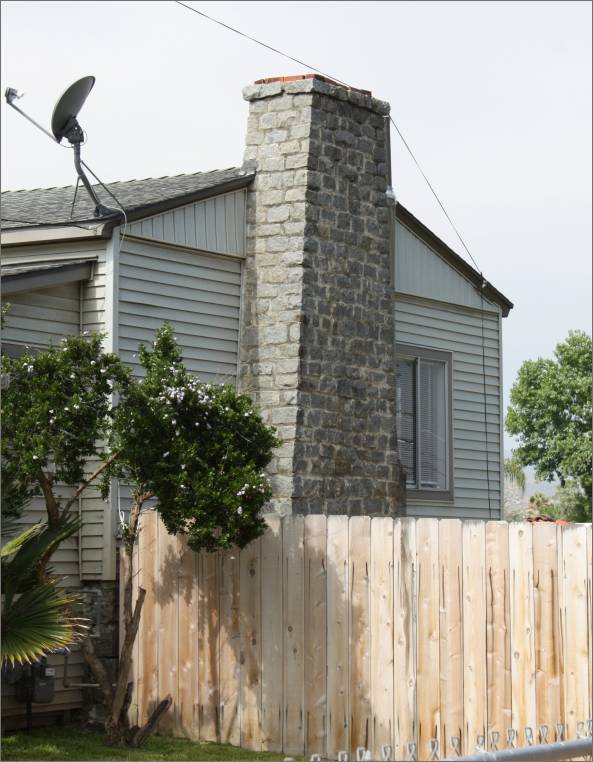
- Santee, San Diego County, California – Chimney of granite quarried at the Simpson-Pirnie Quarry in Santee
According to Jeff McGreevy, the chimney on the house in the photographs below was constructed from the Simpson-Pirnie granite quarry located at Santee. Today Cameron’s Mobile Home Park is located on a large part of the Simpson-Pirnie quarry that once stretched across the valley to where a shopping center is located today.
The photographs below were taken in late May 2012. This is one of the stops on the San Diego County granite quarry tour that Jeff McGreevy took my husband Pat and me on that covered the Santee/ Lakeside/Grossmont, et al. areas. Jeff is a member of the Santee Historical Society and the San Diego Gem and Mineral Society. (You can reach Jeff via his email located above if you’d like to contact him directly.)
You can see photographs of what remains of the Simpson-Pirnie granite quarry in Santee in the “Simpson-Pirnie Granite Quarry at Santee” quarry section of our web site. You can read more about the history of the Simpson-Pirnie granite quarry at Santee in the “Santee, San Diego County, California – the Simpson-Pirnie Granite Company (Granite)” quarry section of our web site. Peggy B. Perazzo

The chimney in the photograph above was constructed from granite quarried at the Simpson-Pirnie quarry in Santee
- Santee, San Diego County, California – the Granite House Memorial Wall & Plaque
The following photographs – and the photographs available in “The Granite House Memorial Wall & Plaque” photo section* of our web site – were taken in late May 2012. The blocks of granite in this wall were quarried from the Simpson-Pirnie quarry in Santee and used in the construction of the house built for Glenn Love circa 1933. Cameron’s Mobile Home Park is located on the site of the quarry today. This was the first stop on the San Diego County granite quarry tour that Jeff McGreevy took my husband Pat and me on that covered the Lakeside/Santee/Grossmont, et al. areas. Jeff is a member of the Santee Historical Society and the San Diego Gem and Mineral Society. (You can reach Jeff via his email located above if you’d like to contact him directly.) (* The “Granite House & Wall” photo section of our web site will be available soon. Peggy B. Perazzo.)


The “Granite House” memorial wall was created from granite blocks from the original Granite house built for Glenn Love, ca. 1933
The Granite House Memorial Plaque
A section of the Granite House Memorial Wall showing examples of the colors of granite quarried at the Simpson-Pirnie quarry
- Sausalito, Marin
County, California – Statue
entitled “Chrysalis” (photograph)
Sausalito Sculptor Welton Rotz used Academy Black granite for his statue entitled “Chrysalis.” You can view a photograph of the sculpture on his web site in Gallery I.
- Sebastopol, Sonoma County, California – the Bank
(built before 1914) (FromReport XIV of the State Mineralogist – Mines and Mineral Resources of Portions of California, Chapters of State Mineralogist’s Report – Biennial Period 1913-1914,
Part II. “The Counties of Colusa, Glenn, Lake, Marin, Napa, Solano, Sonoma, Yolo,” by
Walter W. Bradley, Field Assistant (field work in October and
November, 1913), California State Mining Bureau, San Francisco,
California, 1916, pp. 173-370.)
The light, greenish to yellow trachytic tuff taken from the Stony Point Quarry, located at Quarry Station about halfway between Sebastopol and Petaluma, was used in the construction of the bank at Sebastopol.
- Shasta County, California - Basaltic Lava in Shasta County Used for Monument Work in Local Cemeteries (From The Structural and Industrial Materials of California, Bulletin No. 38, California, State Mining Bureau, San Francisco, California, 1906.)
The basaltic lava in Shasta County "...is adapted for building purposes, resisting exposure to the weather, and may be secured in massive sizes. It can be worked with the ordinary stonecutter's tools, takes a fine polish, and has been employed in local construction and for monument work in local cemeteries."
- Shellville, Sonoma County, California – the Sonoma County Bridge at Shellville South of Sonoma (From Report XIV of the State Mineralogist – Mines and Mineral Resources of Portions of California, Chapters of State Mineralogist’s Report – Biennial Period 1913-1914, Part II. “The Counties of Colusa, Glenn, Lake, Marin, Napa, Solano, Sonoma, Yolo,” by Walter W. Bradley, Field Assistant (field work in October and November, 1913), California State Mining Bureau, San Francisco, California, 1916, pp. 173-370.)
Trachytic Tuff, quarried at the Lounibos Quarry about a mile east of Agua Caliente in Sec. 36, T. 6 N., R. 5 W., was used for the county bridge at Shellville south of Sonoma built in October 1913.
- Shingle Springs, El Dorado County, California - the Wells Fargo Building and Other Stone Buildings and Ruins in Shingle Springs (From Geologic Guidebook Along Highway 49 - Sierran Gold Belt: The Mother Lode Country, Bulletin 141, Olaf P. Jenkins, Chief, California Division of Mines, San Francisco, California, 1949. Used with permission, California Department of Conservation, California Geological Survey.)
"Shingle Springs is located about six miles west of El Dorado on Highway 50. The two-story Wells Fargo Building (Fig. 127) made of meta-andesite and semi-dressed granodiorite, both materials common in the immediate vicinity, is the outstanding building of the late 'fifties at Shingle Springs. Just west of town near the railroad crossing, a well preserved house of meta-andesite fieldstone, talc schist, and white quartz float laid with mud-lime mortar can be seen (Fig. 128). South of there a few hundred yards on the French Creek road are two old building ruins made of meta-andesite and serpentine (Fig. 129)."
Fig. 127. Wells Fargo building, Shingle Springs, DMBS Eld-H10. 
Fig. 128. Stone house ruin just west of Shingle Springs, DMBS Eld-H11. 
Fig. 129. Stone ruin on road to French Creek, DMBS Eld-H12. 
- Siskiyou County, California - Bridge Abutments (From The Structural and Industrial Materials of California, Bulletin No. 38, California, State Mining Bureau, San Francisco, California, 1906.)
The "Southern Pacific Railroad Company has several quarry openings on the Henley sandstone in Sec. 29, T. 47 N., R. 6 W., near Henley. It uses the stone principally for bridge abutments. The quarries are worked by plug-and-feather work."
- Siskiyou County, California - Buildings, Monuments, and Flagstones of Sandstone from the Sandstone Quarries of G. B. Russell prior to 1906. (From The Structural and Industrial Materials of California, Bulletin No. 38, California, State Mining Bureau, San Francisco, California, 1906.)
"The stone is a fine-grained, bluish-gray sandstone. It is used for building and monument work and for flagstones; it resists weathering very well, showing no deterioration after an exposure of over forty years."
- Soledad (southwest of), Monterey County, California – Mission Nuestra Señora de la Soledad, also known as Mission Soledad or Soledad Mission – Uses of Local Stone
Stone was used in the construction at the 21 California Spanish missions for foundations, walls, lintels, walkways, fountains, bases for statues, ditches, aqueducts, etc., when available. You will find more photographs of the Soledad Mission in the “Mission Nuestra Señora de la Soledad” photo tour on our web site. Historical information and photographs of California’s Spanish missions are available in the “The Mission Period (1769–1833) and the Spanish, Mexicans, and Indians in California (expanded version)” section of our web site.
According to the Wikipedia article, “Mission Nuestra Señora de la Soledad, known colloquially as the Soledad Mission or Mission Soledad, is a Spanish mission located near the present-day town of Soledad, California. The mission was founded by the Franciscan order on October 9, 1791 to convert the Native Americans living in the area to Catholicism. It was the thirteenth of California’s Spanish missions, and is the namesake of the city of Soledad.” (Photographs taken in May 2012. Peggy B. Perazzo)


Part of the front view of Soledad Mission
Native American Indian display including grinding stones, pestles, and other implements
Memorial Fountain at the Soledad Mission

View of part of the detriorating adobe walls and stone foundations where the Indian workshops once were located
Structure marking the De Anza Expedition 1775 - 1778 at the Soledad Mission
- Sonoma, California - the Brick House Bungalows Bed and Breakfast (photograph and history) (The link from which this information was obtained is no longer available.)
<http://www.virtualcities.com/ons/ca/w/caw3001.htm>The house Brick Built was built in 1907 to resemble an Italian stone farmhouse from crushed basalt stone from the local quarry.
- Sonoma, Sonoma County, California - Dark Red Rhyolitic Tuff used on Buildings in Sonoma, especially for Trimming on Buildings (From The Structural and Industrial Materials of California, Bulletin No. 38, California, State Mining Bureau, San Francisco, California, 1906.)
A quarry in the foothills one half mile north of Sonoma on the old Vallejo ranch supplied a dark red rhyolitic tuff, "...which has been used considerably in the buildings of Sonoma, especially for trimming buildings constructed of the dark blue basaltic rock of this locality."
- Sonora, Tuolumne County, California - Buildings of Schist (From Geologic Guidebook Along Highway 49 - Sierran Gold Belt: The Mother Lode Country, Bulletin 141, Olaf P. Jenkins, Chief, California Division of Mines, San Francisco, California, 1949. Used with permission, California Department of Conservation, California Geological Survey.)
"...Most of the evidences of the early town are concealed on the main streets by the practice of facing buildings with stucco, vitreous brick and other new materials but the same buildings viewed from side streets and alleyways reveal abundant evidence of early architecture.
"As the visitor enters Sonora from Jamestown, a number of quarries in the schist bedrock can be seen along the right side of Highway 49. These are the sources of the town's favorite stone building material. Across the road to the west shoring and retaining walls made of dry-laid flat schist slabs channel the stream of Woods Creek.
"The favored construction pattern in Sonora was that of making the sides and rears of buildings of flat laid schist slabs, the fronts of brick, but there are some all-brick buildings as well as some all-stone buildings and the influence of the Mexicans is to be seen in surviving adobes.
"The building now (circa 1948) known as the Opera Hall Garage was once the theater for Sonora. It still contains a stage and dressing rooms once used by the players. It has a brick front, and side and rear walls of schist slabs. The hillside behind the opera house was quarried to provide the building material...."
(Other buildings listed as having schist used in the construction of the side and rear walls are: a two-story building at 919 Washington Street, a two-story brick building at 905 Shepard Street with a schist slab foundation; the Purity Store on Stewart Street (Fig. 46), which is an all schist building, and there are walls constructed of schist in various places in Sonora.)
Fig. 42. Building at 803 Stewart St., Sonora, DMBS Tuo-H5. 
- Sonoma, Sonoma County, California – the Sonoma
Cemetery Curbings & other uses* (From Report
XIV of the State Mineralogist – Mines and Mineral Resources
of Portions of California, Chapters of State Mineralogist’s
Report – Biennial Period 1913-1914, Part II. “The
Counties of Colusa, Glenn, Lake, Marin, Napa, Solano, Sonoma,
Yolo,” by Walter W. Bradley, Field Assistant (field work
in October and November, 1913), California State Mining Bureau,
San Francisco, California, 1916, pp. 173-370.)
Trachytic Tuff, quarried at the Lounibos Quarry about a mile east of Agua Caliente in Sec. 36, T. 6 N., R. 5 W., was used for the curbings and other uses in the cemetery* at Sonoma prior to 1913.
(* The name of the cemetery is not given.)


Commercial use of material within this site is strictly prohibited. It is not to be captured, reworked, and placed inside another web site ©. All rights reserved. Peggy B. and George (Pat) Perazzo.