
Quarries in Missouri & Quarry Links, Photographs, and
Articles
Farmington thru Grand River Township
- Farmington Area, St. Francois County, Missouri – the M.
P. Cayce Limestone Quarry (Limestone) (from“Notes
on The Building Stones, Clays and Sands of Iron, St. Francois and
Madison Counties,” by G. E. Ladd, Assistant
Geologist, in Bulletin 1, Geological Survey of Missouri,
Jefferson City, April 1890.)
“M. P. Cayce. In township 35, range 5 east, section 1, southwest quarter, is a limestone quarry which has furnished a small amount of stone, of a poor quality, for foundations in and about Farmington.”
- Farmington Area, St. Francois County, Missouri - the J.
M. Elvins Limestone Quarry (Limestone) (from “Notes
on The Building Stones, Clays and Sands of Iron, St. Francois and
Madison Counties,” by G. E. Ladd, Assistant
Geologist, in Bulletin 1, Geological Survey of Missouri,
Jefferson City, April 1890.)
“J. M. Elvins. In township 36 north, range 4 east, section 12, southwest quarter, is a limestone quarry, in a stone of a yellowish color, which dresses easily. The maximum thickness of any stratum is twelve inches, and blocks of large area are obtainable. The quarry has furnished considerable flagging for Farmington, and also the sills for the Elmwood academy.”
- Farmington, St. Francois County, Missouri -
the Haller Limestone Quarry (Limestone) (The following
information is from The Quarrying Industry of Missouri, by
E. R. Buckley, Director and State Geologist, and H. A. Buehler,
Missouri Bureau of Geology and Mines Vol. II, 2nd Series, 1904.)
“This quarry is just north of the Hawn quarry and the stone is practically the same, being a magnesian limestone. It occurs in thin beds and is used chiefly for foundations and road construction.”
- Farmington, St. Francois County, Missouri - the Haller Limestone Quarry (Limestone), (location) (from Brainy Geography)
- Farmington, Missouri - the Hawn Limestone Quarry (Limestone) (The
following information is from The Quarrying Industry of Missouri, by
E. R. Buckley, Director and State Geologist, and H. A. Buehler, Missouri
Bureau of Geology and Mines Vol. II, 2nd Series, 1904.)
“This quarry, which is located near the northeast limits of the city, consists of an irregular circular opening, having a diameter of 200 feet and a maximum vertical face of 15 feet. The quarry was opened in 1900 and has been operated each year to supply the local market.
“There is very little difference in the stone from different parts of the quarry. It is a fine grained, blue, magnesian limestone, occurring in beds from two to eighteen inches in thickness. Along the joints it has a buff color. When exposed to the atmosphere it takes on a lighter tint.
“The heavier beds contain thin shaly seams, along which they split very readily. The stone contains small crystals of disseminated pyrite and calcite. The beds dip gently in all directions from the center of the quarry.
“The joints strike in many different directions. Those which have been cemented with calcite strike north and south, while others strike N. 60° E., N. 70° E., N. 80° W., N. 5° W., and N. 20° W. The N. 20° W., joints are from three to five feet apart at the east end of the quarry and dip 16° S.W. Near the middle, there are two gentle monoclinal folds, the axes of which strike N. 10° W. In the northeast corner, there is a circular area, separated from the remainder of the rock by curved joints, in which the rock is too hard for building stone.
“The stone is used chiefly for rough masonry and pavements. A small amount has been shipped to Oran. From six to ten men are employed in the quarry during the summer months.”
- Farmington, St. Francois County, Missouri - the Hawn Limestone Quarry (Limestone), (historical quarry) (location) (from Brainy Geography)
- Farmington, Missouri - the Missouri Granite Corporation
(Advertisement) (from Monumental News Magazine,
May 1939, Vol. 51, No. 5, pp. 236. The advertisement below was also
published in the following issue: June 1939, Vol. 51, No. 6, pp.
285; July 1939, Vol. 51, No. 7, pp. 321; August 1939, Vol. 51,
No. 8, pp. 359; September 1939, Vol. 51, No. 9, pp. 424; October
1939, Vol. 51, No. 10, pp. 473; November 1939, Vol. 51, No. 11,
pp. 511; and December 1939, Vol. 51, No. 12, pp. 569.)

At Last...A granite to fill the urgent need for warmth, life and del icate color in Memorials. Such is our Coral Pink. Remarkably bright pink in color, it is at once soft and warm in tone. Equally pleasing axed, steeled or polished; it does not absorb or hold moisture and is easy to work. Answer the trend to color in monuments today by placing a monument or two of Coral Pink granite in your showroom. It will brighten your display and make money for you. Write us.
- Farmington, Missouri - the Missouri Granite Corporation (from Monumental
News Magazine, July 1939, Vol. 51, No. 7, pp. 317.)
A New Pink Granite
“The Missouri Granite Corporation at Farmington, Missouri, have a bright pink granite that ranks with the best grades of imported colored granite.
“The composition is chiefly quartz, feldspar and hornblend (sic), with no trace of pyrite or other discoloring substances. A bright and cheerful pink in color in the steeled or axed finishes, the darkest pink polishes well.
“The quarry is now operating in its fifth year, the product having been sold extensively by salesmen in the local field.”
- Farmington, Missouri - the Missouri Granite Corporation (from Monumental
News Magazine, July 1939, Vol. 51, No. 7, pp. 317.)
- Farmington, Missouri - J. B. Mueller’s Quarry (listed
in The Mine, Quarry and Metallurgical Record of the United States,
Canada, and Mexico, The Mine and Quarry News Bureau, Chicago,
Ill., 1897)
- Farmington (east of), Missouri - the Mueller & Son
Limestone Quarry (Limestone) (The following information
is from The Quarrying Industry of Missouri, by E.
R. Buckley, Director and State Geologist, and H. A. Buehler,
Missouri Bureau of Geology and Mines Vol. II, 2nd Series,
1904.)
“This quarry, which is located a half a mile east of the city limits, is situated along a ravine and has a face 800 feet long and from six to ten feet high. It has been worked intermittently since 1899.
“The north end consists of three feet of red clay stripping, six feet of bluish gray, fine grained limestone and six inches of shale. Directly beneath the stripping and along the bedding planes the stone has a buff color. At the south end the beds are thin, dip gently to the southeast, and have a deep blue color.
“The major joints strike N. 8° E. and are from six to twenty feet apart. Advantage is taken of them in quarrying. The stone is used locally for foundations and road construction.”
- Farmington (east of), Missouri - the Mueller & Son
Limestone Quarry (Limestone) (The following information
is from The Quarrying Industry of Missouri, by E.
R. Buckley, Director and State Geologist, and H. A. Buehler,
Missouri Bureau of Geology and Mines Vol. II, 2nd Series,
1904.)
- Farmington, Missouri - the Spaugh & Westcoat Quarry (listed in The Mine, Quarry and Metallurgical Record of the United States, Canada, and Mexico, The Mine and Quarry News Bureau, Chicago, Ill., 1897)
- Farmington Area, St. Francois County, Missouri - the
Mueller and Son Limestone Quarry (Limestone), (historical
site) (location) (from Brainy Geography)
- Farmington, Missouri - the State Hospital Limestone
Quarry (Limestone) (The following information is
from The Quarrying Industry of Missouri, by E. R.
Buckley, Director and State Geologist, and H. A. Buehler,
Missouri Bureau of Geology and Mines Vol. II, 2nd Series,
1904.)
“This quarry, which is located just east of the road from the main entrance to the buildings, has furnished stone for the foundations of the Hospital buildings. It consists of a semi-circular opening, having a face 250 feet long. The stripping consists of about three feet of red clay underneath which are beds 3 ft. 6 in., 3 ft. and 1 ft. 6. in. in thickness. The stone is a fine grained, bluish gray, semi-crystalline, magnesian limestone. The uppermost bed contains small hackly cavities. As a whole, the beds are thicker and better adapted for constructional work than those at the other quarries. It is expected to install a crushing plant to provide stone suitable for macadamizing the asylum driveways.”
- Farmington, Missouri - the State Hospital Limestone
Quarry (Limestone) (The following information is
from The Quarrying Industry of Missouri, by E. R.
Buckley, Director and State Geologist, and H. A. Buehler,
Missouri Bureau of Geology and Mines Vol. II, 2nd Series,
1904.)
- Farmington Area, St. Francois County, Missouri - the State Hospital Quarry (Limestone), (historical site) (location & map) (from Brainy Geography)
- Farmington Area, St. Francois County, Missouri - the
Mrs. F. E. Toleman Limestone Quarry (Limestone) (from “Notes
on The Building Stones, Clays and Sands of Iron, St. Francois
and Madison Counties,” by G. E. Ladd, Assistant
Geologist, in Bulletin 1, Geological Survey of Missouri,
Jefferson City, April 1890.)
“Mrs. F. E. Toleman. In township 36 north, range 4 east, section 13, southeast quarter of the southeast quarter, is a limestone quarry. It is an open cut, on a hill-side, about seventy feet long and twenty feet wide, with an extreme depth of eight feet. The rock is covered by about four feet of stripping. The stone varies in color from yellow to gray, is fine grained, tough and hard, and is dressed with difficulty. The product has been used for foundations only.”
- Fayette, Missouri - the Kendrick Monument
Company (from Monumental News Magazine, April
1938, Vol. 50, No. 4, pp. 164.)
Trade News: A. K. Kendrick operating the Kendrick Monument Co. at Fayette, Missouri, opened his business there on June 15, 1937. He has an attractive show room three doors from the square, intends to install sand blast and other equipment in the near future.
- Fayette, Missouri - S. B. Kenepp’s Quarry (listed in The Mine, Quarry and Metallurgical Record of the United States, Canada, and Mexico, The Mine and Quarry News Bureau, Chicago, Ill., 1897)
- Festus, Missouri - the River Cement Plant -
Excerpt from Missouri Mining Heritage Guide, by John R.
Park, Stonerose
Publishing Co., Miami, Florida, March 2005. (The following
excerpted quotations are used with the permission of John R. Park,
author.)
“...I’ve been told that the River Cement Plant is visible, at least at a distance. However, when I attempted to visit the site in mid-2004, River Cement Road was gated and posted at its intersection with the I-55 access road - from which there was no view at all of the plant.
“The plant was originally built by the Mississippi River Fuels Corporation. Currently, River Cement Company is a wholly owned subsidiary of RC Cement Company, which is based in Bethlehem, PA.
“The River Cement Plant began operation 1965. The annual capacity is 1.4 million tons. The plant features a 560° long kiln.”
- Florissant, Missouri - the Limestone Quarries
Several online encyclopedias note that there is limestone quarrying operations in Florissant, although no specific information is given.
- Forest City, Missouri - O. C. Plummer’s Quarry (listed in The Mine, Quarry and Metallurgical Record of the United States, Canada, and Mexico, The Mine and Quarry News Bureau, Chicago, Ill., 1897)
- Foristel (north of), St. Charles County, Missouri -
the Camp Creek Quarry Company’s New Quarry (Inkley Marble
Quarries Company) (from Missouri Marble, by
Norman S. Hinchey, Report of Investigations No. 3, Missouri Geological
Survey and Water Resources, Rolla, Missouri, 1946. Used with permission
of the Missouri Department of Natural Resources.)
“This company, headed by Mr. Thomas Inkley, president of the Inkley Marble Quarries Company, has cleared a site for a new quarry three miles north of Foristel, Missouri, in the NW ¼, SE ¼, Sec. 6, T. 47 N., R. 1 E., St. Charles County, on Indiana Camp Creek Road. At the time the site was visited early in May 1946, a small crusher was being set up in the valley of a tributary of Indian Camp Creek, near its mouth. Mr. Inkley reports that he has had samples of the stone cut and polished, and that he will produce marble from this location. Machinery was being installed, but the quarry was not yet in operation at the time the site was examined by the author. The beds exposed in the creek valley-walls are of Mississippian age and belong to the Burlington-Keokuk group of formations. Cursory examination showed that, lithologically, the outcrops include beds of gray limestone and cherty limestone which is crystalline, fossiliferous, and crinoidal in part.”
- Fort Knox, Missouri - the
Rock Quarry at Fort Knox Photograph, presented
on the New Deal Network web site.
Description on the web site: “Rock Quarry at Fort Knox operated by WPA, which produces 1200 tons of crushed rock daily. Rock from this quarry is used in all types of construction at the fort.”
- Frankford, Missouri - the Weatherfrd & Fields Quarry (listed in The Mine, Quarry and Metallurgical Record of the United States, Canada, and Mexico, The Mine and Quarry News Bureau, Chicago, Ill., 1897)
- Franklin, Missouri - John WhitlockMonument Shop (from Granite
Marble & Bronze Magazine, December 1916, Vol. XXVI, No.
12, pp. 34.)
News of the Retail Trade: “John Whitlock, Franklin, Mo., has recently opened retail monument shop in Franklin.”
- Franklin County, Missouri - the Moeslien Rock Quarry, (historical site) (location) (from Brainy Geography)
- Franklin County, Missouri - the Onyx Mines/Quarries (location) (from Brainy Geography)
- Fredericktown, Missouri - the Fredericktown Granite Quarries
(Granite) (from A Report on Mine La Motte Sheet,
including Portions of Madison, St. Francois and Ste. Genevieve
Counties, by Charles Rollin Keyes, State Geologist, Missouri
Geological Survey, Reports on Areal Geology (Sheets 1-4) Volume
IX, 1896)
“Fredericktown Quarries. - In the vicinity of Fredericktown a number of openings have been made. About 300 yards north of the station east of the railroad track there is a small quarry. An excavation twenty feet square and twelve feet deep has been quarried out and worked into paving blocks. The rock is a fine-grained grayish pink stone, with easy fracture.
“In the southeast quarter of section 6 (Tp. 33 N., R. VII E.) several small quarries have been opened up in a red granite; and from time to time the output of blocks is quite large. The blocks are of first-class quality and are easily made. At present no work is done in the locality.”
- Fredericktown, Missouri - the Allen and
Smith Marble Quarry (Formerly known as the Covert Quarry & the
Cedar Bottom Quarry (Marble) (from A Report on Mine
La Motte Sheet, including Portions of Madison, St. Francois and
Ste. Genevieve Counties, by Charles Rollin Keyes, State Geologist,
Missouri Geological Survey, Reports on Areal Geology (Sheets 1-4)
Volume IX, 1896)
“Allen & Smith Quarry. - Formerly the opening was known as the Covert, or Cedar Bottom, quarry. It is located about three miles south of Silver mines and ten miles southwest of Fredericktown (Tp. 33 N., R. V E., Sec. 25, SE. qr). It lies in the largest deposit in the district, covering about one square mile. Most of the area is of very gentle slope, but in spite of the low surface relief but little debris has collected over the greater portion of the marble deposit, and in places the thickness of the residual clays barely cover the hard layers. In color and texture the stone varies greatly. Some ledges are flesh-colored; others the same but clouded with, light streaks; others are of darker shades of red, either uniform or motled (sic); while certain strata are of a very dark cherry red color. The texture is homogeneous. For the most part the stone has a compact, fine-grained matrix, through which are scattered small grains of more coarsely crystallized material either of marble or of pure calcite. Then there are thinner layers of semicrystalline rock of a uniform texture; others of either of those mentioned, with an occasional band more crystalline and sometimes thin broken streaks of dark red clayey material. The latter occurs in occasional layers and is not deleterious. The stone dresses readily. The ledges are from a few to twenty-four inches in thickness. Almost any desired size of blocks may be secured. Being the surface rock with little or no stripping and in a well-drained locality quarrying is carried on with almost no obstacle to intefere (sic). The marble is hard and slightly brittle but takes a splendid polish and is suitable for monuments, mantles and ornamental work, and especially indoor trimmings and decorations.”
- Fredericktown, Missouri - the Rufus Beard Quarry (listed in The Mine, Quarry and Metallurgical Record of the United States, Canada, and Mexico, The Mine and Quarry News Bureau, Chicago, Ill., 1897)
- Fredericktown (east of), Missouri - the
Berryman Limestone Quarry (Limestone) (from A Report
on Mine La Motte Sheet, including Portions of Madison, St. Francois
and Ste. Genevieve Counties, by Charles Rollin Keyes, State
Geologist, Missouri Geological Survey, Reports on Areal Geology
(Sheets 1-4) Volume IX, 1896)
“Berryman Quarry lies just east of Fredericktown on the south side of Saline creek. It was opened a number of years ago and the stone was used for burning into lime. The present face is about twenty feet long and fifteen feet high with no stripping. The ledges are light gray, hard, with a subcrystalline texture and from three to nine inches thick. It is easily quarried and is a good stone for constructional purposes. Much of the stone obtained from this quarry has been utilized for foundations.”
- Fredericktown, Missouri - the Cedar Bottom
Marble Quarry
See: Fredericktown, Missouri - the Allen and Smith Marble Quarry above.
- Fredericktown, Missouri - the Covert Marble
Quarry
See: Fredericktown, Missouri - the Allen and Smith Marble Quarry above.
- Fredericktown (west of), Missouri - the Davis Limestone
Quarry (Limestone) (The following information is from The
Quarrying Industry of Missouri, by E. R. Buckley, Director
and State Geologist, and H. A. Buehler, Missouri Bureau of Geology
and Mines Vol. II, 2nd Series, 1904.)
“This quarry, which is owned and operated by R. N. Davis, is located on the northwest side of a hill, one and one-half miles west of Fredericktown. It has been operated since 1894 and ha a face of 150 feet. The following is a description of the beds from the top to the bottom:
3 ft. - Red clay stripping.
1 ft, 7 in. - Bluish gray, fine grained, compact limestone. Badly broken by joints.
1 ft., 8 in. - Dark blue, fine grained limestone, containing dries.
2 ft. - Fine grained limestone. Upper six inches has a mottled gray color. Lower portion is blue and shelly.
1 ft., 6 in. - Somewhat mottled, bluish colored limestone. The middle of the bed contains a six inch layer of dark colored limestone.
“The beds in this quarry dip slightly to the south and are badly broken with joints which strike N. 58° W. At the east end, six feet of stone is quarried above the beds described in the section. This stone occurs in beds from six to twelve inches in thickness and is interstratified with thin layers of shale.
“The quarry is operated from March 1 st to December 1 st and employs four men who work with hand tools and a horse power derrick.
“The stone from this quarry has been used in the Marvin Collegiate Institute and Dormitory and in the new courthouse at Fredericktown. It has been shipped to Charleston, Bertrand and Silverton, Missouri.”
- Fredericktown (south of), Missouri - the
Dolomite Quarry (Dolomite) (from A Report on Mine
La Motte Sheet, including Portions of Madison, St. Francois and
Ste. Genevieve Counties, by Charles Rollin Keyes, State Geologist,
Missouri Geological Survey, Reports on Areal Geology (Sheets 1-4)
Volume IX, 1896)
“Other quarrying has been done in the dolomite formation especially to the east and south of Fredericktown and also near Libertyville. At both localities splendid ledges for building stone have been developed.”
- Fredericktown (northwest of), Missouri -
the Downs Limestone Quarry (Limestone) (from A Report
on Mine La Motte Sheet, including Portions of Madison, St. Francois
and Ste. Genevieve Counties, by Charles Rollin Keyes, State
Geologist, Missouri Geological Survey, Reports on Areal Geology
(Sheets 1-4) Volume IX, 1896)
“Downs Quarry. - This quarry is about two miles northwest of Fredericktown (Tp. 33 N., R. VI E., Sec. 11, NE. ¼ of NW. qr). It is circular in shape. The stripping has a maximum thickness of four feet but usually only from three to fifteen inches. This covering is of residual clays and there is a decomposed limestone ledge present. The strata here dip with the floor of porphyry about 15 degrees, south of 20 degrees east. The actual juncture is not distinctly shown, but crystalline rocks are exposed only a few feet up the hillside from the quarry. The same dip of strata is noticed for nearly half a mile to the southeast and is one of the best illustrations of the slant of the sedimentaries agreeing in places with the angle of the slope of the granite floor. The top ledge of limestone is from three to twelve inches in thickness. It thins out up the slope. It is of a light grayish color, is finely textured and of dull luster. It is taken out in slabs containing eighteen square feet and is well adapted for curb stones, water tables and well rocks. Under the first layer comes a heavy ledge of very similar character but containing fewer grayish to buff horizontal seams. It is a good building stone but has not been extensively used. Much of the stone for the new college building at Fredericktown was taken from this quarry.
- Fredericktown, MadisonCounty, Missouri - the H. L. Gale
Marble Quarry (Marble) (from“Notes on The Building
Stones, Clays and Sands of Iron, St. Francois and Madison Counties,” by
G. E. Ladd, Assistant Geologist, in Bulletin 1, Geological
Survey of Missouri, Jefferson City, April 1890.)
“H. L. Gale. About eight miles south of Fredericktown, on the farm of Mr. Gale, a small opening was made in a marble outcrop, about ten years ago. Two strata of marble are exposed here, one being about seven inches thick, and the other about eighteen. The thinner stratum of these has a pale pink color which shades into a lavender, and is relieved by specks and streaks of calcite, arranged in parallel lines, giving the whole stone a subdued but very handsome effect. It takes an excellent polish. The thicker stratum has a pale grayish tint, slightly variegated by green and brown streaks. These marbles are fine grained, and are somewhat ‘plucky’ under the stone cutter’s tools. It is probable that there are several strata of good marble here; but the beds of residuary products make it difficult to determine this fact on a cursory examination. Only one car load has been shipped from here, which went to St. Louis.”
- Fredericktown, Missouri - L. M. Hebener’s Quarry (listed in The Mine, Quarry and Metallurgical Record of the United States, Canada, and Mexico, The Mine and Quarry News Bureau, Chicago, Ill., 1897)
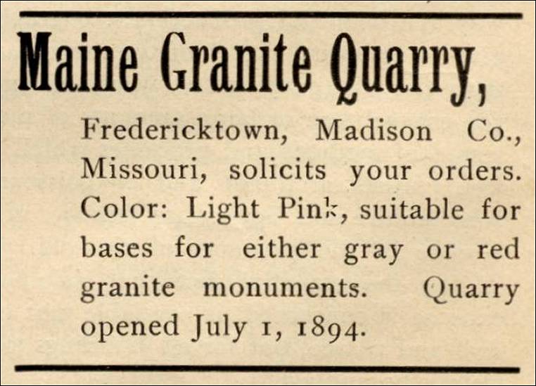
- Fredericktown, Madison County, Missouri – Maine
Granite Quarry (The following advertisement is from
The Monumental News, August, 1895, Vol. 7, No. 8, Chicago, Illinois,
pp. 519.)

Maine Granite Quarry, Fredericktown, Missouri
Fredericktown, Madison Co., Missouri, solicits your orders. Color: Light Pink, suitable for bases for either gray or red granite monuments. Quarry opened July 1, 1894.
- Fredericktown, Missouri - Richard Thompson’s Quarry (listed in The Mine, Quarry and Metallurgical Record of the United States, Canada, and Mexico, The Mine and Quarry News Bureau, Chicago, Ill., 1897)
- Fulton, Missouri - E. Denkelberg’s Quarry (listed in The Mine, Quarry and Metallurgical Record of the United States, Canada, and Mexico, The Mine and Quarry News Bureau, Chicago, Ill., 1897)
- Fulton, Missouri - Simcoe & Foster (from Stone:
An Illustrated Magazine, December 1897, Vol. XVI., No. 1,
pp. 84)
Notes From Quarry and Shop: “The firm of Simcoe & Foster, Fulton, Mo., has been dissolved. Geo. W. Foster will continue.”
- Gainesville, Missouri - the Hogard & Miller Quarry (listed in The Mine, Quarry and Metallurgical Record of the United States, Canada, and Mexico, The Mine and Quarry News Bureau, Chicago, Ill., 1897)
- Gallatin, Missouri - the Brosins Limestone Quarry (Limestone) (The
following information is from The Quarrying Industry of Missouri, by
E. R. Buckley, Director and State Geologist, and H. A. Buehler,
Missouri Bureau of Geology and Mines Vol. II, 2nd Series, 1904.)
“The quarry owned by Samuel T. Brosins was opened in 1886 along the railroad east of the Cubberly quarry. It is located in the S.W. ¼ of N.E. ¼, sec, 17, T. 29, R. 27 W. The stone is blue and gray limestone, very similar to that in the other quarries of Gallatin.
“The stone from this quarry has been used by the Chicago, Rock Island and Pacific railroad to build bridge abutments and retaining walls. It is suitable for breakwater, foundations, bridge abutments, curbing and retaining walls. The quarry has been idle for a number of years.”
- Gallatin, Missouri - E. J. Dee’s Quarry (listed in The Mine, Quarry and Metallurgical Record of the United States, Canada, and Mexico, The Mine and Quarry News Bureau, Chicago, Ill., 1897)
- Gallatin, Missouri - the Gallatin Area Limestone
Quarries (Limestone) (The following information is from The
Quarrying Industry of Missouri, by E. R. Buckley, Director
and State Geologist, and H. A. Buehler, Missouri Bureau of Geology
and Mines Vol. II, 2nd Series, 1904.)
“Three quarries, known as the Cubberly, the Walker and the Brosins, have been opened in the vicinity of this city. They are in limestone of Pennsylvanian or Upper Carboniferous age. The quality of the stone is essentially the same in all these quarries.”
- Gallatin, Missouri - the Cubberly Limestone Quarry (Limestone) (The
following information is from The Quarrying Industry of Missouri, by
E. R. Buckley, Director and State Geologist, and H. A. Buehler,
Missouri Bureau of Geology and Mines Vol. II, 2nd Series, 1904.)
“The quarry owned and operated by Albert Cubberly is located in the outskirts of the city, just south of the Chicago, Rock Island and Pacific railroad. It was opened six years ago and has been worked intermittently to supply the local demands. It is on the east side of the hill and consists of two openings, one above the other, separated by a soil covered slope. The faces at the two openings expose the following succession of strata:
Upper opening:
0-1 ft. - Dirt stripping.
1-3 ft. - Limestone broken into about two inch pieces. Called ‘Natural Macadam.’
6 in. - Very fine grained, light colored limestone. Spalls hard.
8 in. - Similar rock but not so difficult to work.
6 in. - Finely crystalline, light gray limestone.
7 in. - Fossiliferous, fine grained, light gray limestone.
10 in. - Gray, fossiliferous, medium textured limestone.
7 in. - Dark gray limestone, dresses easily. Top portion shelly; not injured by frost.
Lower Opening:
2-5 ft. - Yellow clay and broken stone stripping.
2 ft. 8 in. - Dark gray, fossiliferous limestone; buff colored along bedding planes. Can be split into beds six inches in thickness.
1 ft. - Gray shale.
2 ft. - Dark, compact, fossiliferous limestone. Weathered to a brownish color along bedding planes.
“Two prominent sets of joints in the lower beds strike N. 40° E. and N. 40° W. These joints are from three to four feet apart, breaking the stone into nearly cubical blocks.
“The thickness of the clay stripping and the difficulty experienced in separating the beds makes the stone in the lower opening more expensive to quarry than that in the upper. For this reason the upper opening is being worked at present.
“The beds in this opening are uniform in thickness and dress readily into caps, sills and coursing. The upper beds spall and work hard, while the lower ones dress with little difficulty. The waste stone is broken by hand and used for macadam. Only hand tools are used.”
- Gallatin, Missouri – Tillery & Brown,
Marble and Granite (from Stone: An Illustrated Magazine,
April 1897, Vol. XIV, No. 5, “Notes from Quarry and Shop” section,
pp. 636)
“Gallatin, Mo. – Tillery & Brown, marble and granite; N. B. Brown gave real estate mortgage for $500.”
- Gallatin, Missouri - the Walker Limestone Quarry (Limestone) (The
following information is from The Quarrying Industry of Missouri, by
E. R. Buckley, Director and State Geologist, and H. A. Buehler,
Missouri Bureau of Geology and Mines Vol. II, 2nd Series, 1904.)
“This quarry is located near the eastern limits of the city and is owned and operated by Sam Walker. It was opened in 1897 on a four-acre tract of land. The face is irregular and about 600 feet long. At the time the quarry was examined there was exposed 3 ft. 4 in. of bluish finely crystalline, fossiliferous limestone in beds from six to eight inches in thickness. These beds are blue in the interior and buff on the exterior. They are separated from one another by thin clayey seams. Six feet of yellow and red clay stripping occurs above this bed. Five beds from six inches to one foot in thickness are worked below that which is exposed.
“The joints strike N. 45° E. and No. 60° W. The stone is used for foundations, wells, and macadam. Two car loads of crushed stone, broken by hand, have been shipped to Chillicothe. It is sold for $2.50 a yard F.O.B. Gallatin.”
- Glasgow (near), Missouri – Limestone Quarry near
Glasgow, Missouri (circa
1899) (from Stone: An Illustrated Magazine,
Vol. XIX, No. 6, “Limestone and Sandstone” section,
pp. 560.
“A new limestone quarry has been opened near Glasgow, Mo., and the stone is being used for the Government work near that town.”
- Glasgow, Missouri - H. B. Simmons’ Quarry (listed in The Mine, Quarry and Metallurgical Record of the United States, Canada, and Mexico, The Mine and Quarry News Bureau, Chicago, Ill., 1897)
- Glen Park, Jefferson County, Missouri - Bluff Limestone Quarry & Lime Kilns (Limestone) (from Limestones and Dolomites in the St. Louis Area, Report of Investigations No. 5, by Norman S. Hinchey, R. B. Fisher, and W. A. Calhoun, State of Missouri Department of Business and Administration, Division of Geological Survey and Water Resources, Rolla, Missouri, 1947. Used with permission.) (For an explanation of the study of which this section is a part, see: St. Louis Area of Missouri - Limestones and Dolomites in the St. Louis Area (St. Louis County, Jefferson County, and Lincoln County)
Locality P (Field Descriptions and Analytical Information)
“Remarks. The samples at this location were taken from the face of the bluff quarry and the tunnel quarry in the bluff. This is the south tunnel quarry at Glen Park, Missouri. It was not being worked at the time it was sampled in 1946, as activities then were restricted to the north tunnel quarry, about one-fourth mile to the north (locality Q of this report).
“Location. At Glen Park, Jefferson County, Missouri, in the SE ¼ NW ¼ sec. 5, T. 41 N., R. 6 E., approximately one-half mile southwest of Glen Park station.
“Transportation. An all-weather road leads to the quarry. The quarry and lime kilns are served by a siding of the Missouri Pacific Lines. The crusher and kilns of the quarry are but a few rods from the main line of the railroad and from the west bank of the Mississippi River.
“Elevation. The base of the section sampled is approximately 400 feet above sea level.
“Stratigraphic Position. The beds sampled at this place are in the Kimmswick formation of Ordovician age. The base of the section sampled is at a horizon approximately 70 feet beneath the top of the Kimmswick and about 20 feet above its base. At this place the Kimmswick is immediately overlain by the Fernvale formation (Ordovician).
“Samples. Eighteen Samples, P-1 to P-18, inclusive, were taken from the Kimmswick formation at this locality. A single sample, P-19, was taken from the Fernvale formation.
“Geologic Section. The section sampled may be described, from top to bottom, in the following manner:
“Note: This freshly quarried face of the Kimmswick shows the relative homogeneity which is often characteristic of unweathered sections oft the formation. Bedding is indistinct, and the formation here does not lend itself to ready differentiation into vertically delimited units which are distinct. The description given is therefore a generalized description of the gross features of the section:
5. Fernvale formation: Limestone, dark, bluish-gray, coarsely crystalline and highly fossiliferous. Sample P-19 was taken from the middle of the bed. (Overlain by Mississippian strata) - 1 ½ feet.
4. Kimmswick formation: Limestone, gray, crystalline and fossiliferous. This upper portion was not examined in detail. Elevation, 452 to 470 feet. - 18 feet.
3. Limestone, light gray to brownish-gray, coarsely crystalline to finely crystalline; a suggestion of horizontal indistinct darker banding in the fresh face which produces a horizontally somewhat ‘fluted’ surface where weathered; these latter bands are broadly lens-shaped and not laterally continuous. Elevation, 434. Sample P-18 was taken at an elevation of 442 feet; Sample P-17 was taken at an elevation of 440 feet; Sample P-16 was taken at an elevation of 438 feet; Sample P-15 was taken at an elevation of 435 feet. - 18 feet.
2. Limestone, gray and brownish-gray, crystalline to coarsely crystalline. Arbitrarily, the base of this unit was taken at the top of the tunnel entry to the underground quarry. Elevation, 420 to 434 feet. Samples were taken as follows: P-14 at al elevation of 431 feet; P-13 at 430; P-12 at 425 feet; P-11 at 422; and P-10 at 420 feet. - 14 feet.
1. Limestone, similar to No. 2 above; constitutes the entry walls to the underground tunnel quarry. Elevation, 400 to 420 feet. Samples were taken as follows: Sample P-9 at an elevation of 417 feet; P-8 at 414; P-7 at 412; P-6 at 409; P-5 at 407; P-4 at 405; P-3 at 404; P-2 at 402; and P-1 at 400 feet (quarry floor). - 20 feet.
Base of section sampled. This is the level of the floor of the outside quarry, west of the underground quarry.
“Note: The following general remarks may be noted in further describing the section given above:
“(a) The limestone beds are massive, with indistinct stylolitic tight partings which are from 2 inches to 2 feet apart.
“(b) Bedding planes, which can be followed with the eye across the quarry face, were seen at approximate elevations; 407 feet (poor), 420 (fairly distinct), 438 (distinct at places), 452 (poor), and 470 (at the contact with the overlying Fernvale formation).
“(c) Indistinct horizontal ‘flutings’ occur along the weathered surface of parts of the section.
“(d) Color variations are slight, but vary from light gray to some pinkish-gray and buff-tinged gray.
“(e) Grain size varies up to crystal faces (cleavages) 2 mm. in diameter.
“(f) Many calcite-filled vugs are present.
“(g) A number of thin (4-inch) horizontal lenses of dark gray, finer-grained limestone are seen between elevations of 434 and 452 feet.
“(h) Much of the rock is highly fossiliferous, but some beds are free of fossils.
Analytical Information on Limestone Samples of Kimmswick Formation At Locality P. The chemical analyses of the 18 samples of the Kimmswick formation and 1 sample of the Fernvale formation at locality P are as follows:
Analyses of Samples at Locality P. 
B. Kimmswick limestone in tunnel quarry at Locality P, one-half mile southwest of Glen Park station, Jefferson County, Missouri. 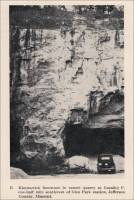
- Glen Park, Jefferson County, Missouri - the North Tunnel Limestone Quarry (Limestone) (from Limestones and Dolomites in the St. Louis Area, Report of Investigations No. 5, by Norman S. Hinchey, R. B. Fisher, and W. A. Calhoun, State of Missouri Department of Business and Administration, Division of Geological Survey and Water Resources, Rolla, Missouri, 1947. Used with permission.) (For an explanation of the study of which this section is a part, see: St. Louis Area of Missouri - Limestones and Dolomites in the St. Louis Area (St. Louis County, Jefferson County, and Lincoln County)
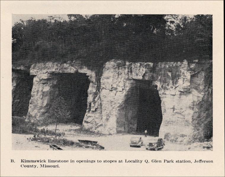
Locality Q (Field Descriptions and Analytical Information)
“Remarks. Locality Q is about 1,500 feet northeast of locality P (above) in the same quarried area. Parts of the sections at each of the two locations are in the same stratigraphic positions in the Kimmswick formation, as will be noted in referring samples at either locality to the superjacent Fernvale formation. Locality Q was (in 1946) being worked as a tunnel quarry. All of the samples from this locality were taken from the underground face of the tunnel quarry, which has a 40-45 foot ceiling.
“Location. In the NE ¼ SW ¼ sec. 5, T. 41 N., R. 6 E., Jefferson County, Missouri, at Glen Park station on the Missouri Pacific Lines. This is the north tunnel quarry on the property.
“Transportation. All-weather roads lead to the quarry. A short spur of the Missouri Pacific Lines serves the quarry lime kilns, and the quarry is but a few rods from the railroad’s main line, as well as from the west bank of the Mississippi River.
“Elevation. The floor of the quarry is approximately 400 feet above sea level.
“Stratigraphic Position. The beds sampled are all in the Kimmswick formation of Ordovician age. The quarry floor is at a horizon 60 feet below the top of the Kimmswick formation, which is, at that point, overlain by the Fernvale limestone, also of Ordovician age. A water well, drilled at the elevation of the quarry floor, encountered the base of the Kimmswick formation (top of the underlying Decorah formation) at a depth of 30 feet.
“Samples. Because of the lack of visible distinct units in the freshly quarried face, samples were taken at rather closely spaced vertical intervals. Twenty-one samples, Q-1 to !-16 (e), were taken; and the elevations are noted in the geologic section described briefly below. All samples were taken from the face in the tunnel quarry, about 250 feet back from (east of) the portal entrance to this underground quarry.
“Geologic Section. The following is a briefly summarized description of the section in the tunnel quarry and of the beds above the ceiling of that quarry as seen in the open quarry at the surface to the west.
5. Limestone, cherty limestone, sandstone, and shale of Mississippian age. Not examined in detail.
4. Shale (Maquoketa formation of Ordovician age). Not examined in detail.
3. Fernvale formation: Limestone, dark bluish-gray, highly crystalline and fossiliferous. - 1 ½ feet.
2. Kimmswick formation: Limestone with a little chert in flattened lenses and nodules, gray, crystalline. Not sampled or examined in detail. Thickness (above portal to tunnel quarry.). - 15 feet.
1. Limestone with a very few small lenses of chert at places in the upper 10 feet, gray and light brownish-gray, crystalline to coarsely crystalline, at places calcite-filled vugs are seen; massive beds, with a few brownish stylolitic partings; bedding is indistinct in this freshly quarried face; essentially chert-free; some slight cross-bedding at places. Elevation of floor, 400; of roof, 445 feet. Samples were taken as follows: Samples Q-16A, Q-16B, Q-16C, and Q-16E were taken at random from blocks shot down from the roof, all between elevations 437 and 446 feet; samples Q-15 was taken at an elevation of 429 feet, and sample Q-16A was taken at an elevation of 429 feet, and sample Q-15A was taken at an elevation of 435 feet. Sample Q-14 was taken at an elevation of 428 feet. Q-13 was taken at an elevation of 426 feet. Q-12 was taken at an elevation of 424 feet. Q-11 was taken at an elevation of 421 feet. Q-10 was taken at an elevation of 417 feet. Q-9 was taken at an elevation of 415 feet. Q-8 was taken at an elevation of 412 feet. Q-7 was taken at an elevation of 411 feet. Q-6 was taken at an elevation of 409 feet. Q-5 was taken at an elevation of 406 feet. Q-4 was taken at an elevation of 405 feet. Q-3 was taken at an elevation of 404 feet. Q-2 was taken at an elevation of 403 feet. Q-1 was taken at an elevation of 401 feet.
Base of section is floor of quarry (elevation, 400 feet).
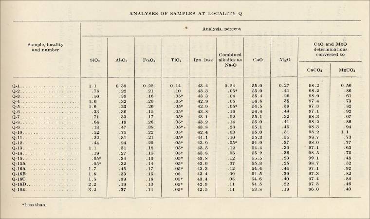
Analytical Information on Limestone Samples of Kimmswick Formation At Locality Q. The chemical analyses of the 21 samples of the Kimmswick formation at locality Q are as follows:
Analyses of Samples at Locality Q. 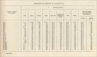
A. Kimmswick limestone showing room and pillar stope at Locality Q. Glen Park station Jefferson County, Missouri.

B. Kimmswick limestone in openings to stopes at Locality Q. Glen Park station, Jefferson County, Missouri. 
- Glencoe (near), St. Louis County, Missouri - Limestone Exposure in the “north bluff of Meramec River on the right-of-way of the Missouri Pacific Lines (Limestone Exposure) (from Limestones and Dolomites in the St. Louis Area, Report of Investigations No. 5, by Norman S. Hinchey, R. B. Fisher, and W. A. Calhoun, State of Missouri Department of Business and Administration, Division of Geological Survey and Water Resources, Rolla, Missouri, 1947. Used with permission.) (For an explanation of the study of which this section is a part, see: St. Louis Area of Missouri - Limestones and Dolomites in the St. Louis Area (St. Louis County, Jefferson County, and Lincoln County)
“Locality A (Field Descriptions and Analytical Information)
“Remarks. Samples were taken from the Joachim formation near Glencoe, St. Louis County Missouri. The exposure is in the north bluff of Meramec River on the right-of-way of the Missouri Pacific Lines, (‘Glencoe branch line’ along left bank of river from Jedburg to Glencoe and Acadia).
“Location. Exposure near the center, NW ¼ sec. 19, T. 44 N., R. 4 E., St. Louis County, Missouri, and is about 1,000 feet east of Glencoe station on the Missouri Pacific Lines.
“Transportation. The exposure is on the line of the Missouri Pacific Lines and on the Meramec River.
“Elevation. The base of the section sampled is at track level, 438 feet above sea level.
“Stratigraphic Position. The base of the section is 55 feet below the top of the Joachim formation (Ordovician). The top of the section is 41 feet below the top of the Joachim. Thus, all of the samples were from the Joachim formation.
“Samples. Three samples, A-1 to A-3, inclusive, were taken at this locality.
“Geologic Section. The sequence, from top to bottom, is as follows:
3. Limestone, dolomite, and impure limestone and dolomite; upper part of Joachim and lower part of Plattin formation. The Plattin-Joachim contact is 55 feet above track level and at an elevation of 493 feet. These beds were not examined in detail. Distance to top of bluff - 110 feet.
2. Dolomite, ‘cotton rock,’ impure, buff-tan, fine-grained; grades upward into No. 3. Sample A-3 was from the middle of this bed No. 2 - 2 feet.
1. Dolomite, ‘cotton-rock,’ buff-tan, fine-grained; in beds from 4 to 12 inches thick; a few irregular and discontinuous, thin shaly dolomite partings. Sample A-1 was taken 3 feet above base, and sample A-2 was taken 9 feet above base - 12 feet.
Base of section (track level). Elevation, 438 feet.”
Analytical Information on Dolomite Limestone Samples of Joachim Formation At Locality A. Chemical Analysis. The chemical analyses of the three dolomite limestone samples of the Joachim formation at locality A are given below: 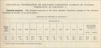
- Glencoe, St. Louis County (western part),
Missouri - the Glencoe Lime Company Limestone Quarry (Limestone)
today the Rockwoods Reservation, presented by Jeff Saxton. (The
web site from which the following information was obtained has
been shut down.)
<http://hometown.aol.com/jbsaxton/Rockwoods.html>According to this web site, Rockwoods Reservation, a unit of the Missouri Conservation Commission, was originally a quarry and mining operation. Today the area is available to the public as a nature and hiking preserve. The land was purchased from Glencoe Lime Company, the previous owner and operator, “who had mined and quarried limestone, shales, and gravels from the area since the late 1860’s.” You can still see the two open pit quarries and a cavern. One of the four kilns remains on the property.
- Rockwoods Reservation, today a wildlife conservation area, presented on Wikipedia.
- Glencoe, Missouri - the Glenco Lime & Cement Company Marble Quarry Today viewed from the “Rock Quarry Trail” in the Rockwoods Reservation -. Excerpt from Missouri Mining Heritage Guide,
by John R. Park, Stonerose Publishing Co., Miami, Florida, March 2005. (The following excerpted quotations are used with the permission of John R. Park, author. A photograph of one of the lime kilns is included in John Park’s article.)
(Visit Wikipedia’s section on the Rockwoods Reservation to learn more about the area.)
“...The Rockwoods Reservation is a nature reserve on the site of a former marble quarry and lime production facility. A masonry lime kiln at the beginning of Lime Kiln Trail, is said to be the oldest of 5 originally on the site. An explanatory plaque, with a diagram, explains the operation of the kiln.
“The Rock Quarry Trail passes old rock quarries as well as Cobb’s Cavern. ‘Cobb’s Cavern’ is a former underground limestone mine, nominally off-limits to the public, but viewable from a moderate distance.
“Interpretive signs throughout the area point out special features and demonstration areas, including a butterfly garden, prairie habitat, mining, and the history of the lime kilns.
“Note, this peculiar use of the word ‘reservation’, meaning ‘nature preserve’ and having nothing to do with American Indians, is probably borrowed from similar usage in Massachusetts.
“Quarrying began in 1868 by the Cobb-Wright-Case Mining Company. The marble quarried from the Kimmswick Formation was technically unmetamorphosed limestone. The rock was cut into 10’ cubes by steam-powered rock saws. The cubes were then cut into slabs, loaded on railroad cars, and transported on a spur to the Missouri Pacific Railroad (no Union Pacific Railroad) at Glencoe. However, most of the marble (limestone) was deemed too soft to be useful as dimension stone.
“In 1875 two large, square, stone kilns were erected. A year later the Glenco Lime & Cement Company was organized. Eventually the enterprise grew to eleven kilns, in two groups. About 1907, the limeworks were the second largest in Missouri.
“Six quarries were developed for lime production. At least one of the quarries extended laterally underground. The underground quarry, ‘Cobbs’ Cavern’, is said to be ‘larger than a football field in size’. From the quarries the limestone was loaded on cars and hauled by mules to the end of the quarry. From there, the cars were lowered by cable down a steep inclined tramway. From the bottom of the incline, the cars moved by gravity (i.e., on gentler incline). At the plant the cars were hauled up an incline to the top of the kilns by cable. The empty cars were returned to the base of the hill by mules, to be hauled back up the incline.
“Five of the lime kilns were located at the quarries, 2 on one side of the valley, 3 on the other side. Probably the two masonry kilns (presumably including the surviving kiln) had a capacity of 500 bushels/day each. They were retired from service sometime prior to 1907. Interestingly, the capacity of the younger 3 (probably iron shelled) kilns was only 200 bushels per day each, and they were fired with a 50:50 charge of wood and coal.
“Six iron-shelled kilns were located about half-way to Glencoe. These were coal-fired and each had a capacity of 250 bushels per day. All of the 9 kilns in operation in 1907 had forced-air ventilation.
“A Griffin mill (installed near the lower kilns) was used to grind lime for agricultural use. As the limestone was impure, the lime produced was gray (and known as black lime). Thus, it was unsuitable for use as whitewash or a white mortar - but had many other uses.
“Gravel and clay/shale were mined from an area on the northern part of the property. The gravel was used in road construction while the (common) clay was used for clay pipe and low-grade terra cotta. This site now resembles a huge sinkhole 800’ across.
“The Glencoe Lime Company went broke in 1938 after 70 years of mining in the area....”
- Glendale (southeast of), Missouri - the Stolle Stone Company’s Limestone Quarry (Limestone) (The following information is from The Quarrying Industry of Missouri, by E. R. Buckley, Director and State Geologist, and H. A. Buehler, Missouri Bureau of Geology and Mines Vol. II, 2nd Series, 1904.)
“This quarry was opened in 1888 by the Glendale Quarry Co. Later it passed into the hands of the Grant Quarry Co., and at present it is owned and operated by the Stolle Stone Co. It is located three and one-half miles east of Kirkwood and one and one-fourth miles southeast of Glendale, and is connected by side track with the St. Louis, Iron Mountain and Southern Railroad.
“The quarry has a west face 650 feet long. The following is a description of the beds from top to bottom:
12-15 ft. - Gray to buff colored limestone, in beds from six to twenty-four inches in thickness. Used for rip rap, macadam, and rubble.
4 ft. - Fine grained limestone, known as the white ledge. Splits in places along suture joints. Contains an occasional dry. Bunches of fossil remains cause the stone to vary somewhat in hardness.
1 ft. 2 in. - Fine grained limestone known as the ‘leather ledge.’ This stone is very hard to spall, but splits well with plugs and feathers. Is used for footing and sewer intakes.
2 ft. 4 in. - Fine grained, fossiliferous, bluish gray limestone known as the ‘hard blue ledge.’ Difficult to saw but breaks well with plugs and feathers. Used mainly for bridge stone.
4 ft. - Fine grained, bluish gray limestone known as ‘soft blue ledge.’ Splits along shale seams into three beds of 12, 18 and 18 inches. A layer of partly decomposed chert nodules occurs along the bed. The stone contains an occasional dry.
3 ft. - Hard, dark gray limestone. In some portions of the quarry this bed feathers out and disappears. This stone works well.
4 ft. - Somewhat oölitic, light gray limestone. Splits eighteen inches from the bottom. Saws well. Is injured by frost when first quarried. Is known as the Stockton ledge.
“The major set of joints strike N. 45° E. and N. 45° W. They occur from twenty to fifty feet apart.
“The stone from the upper part of the quarry is used mainly for rubble and is blasted with very little regard to the jointing planes. The stone from the lower part is used for building purposes, and careful attention is given to the jointing planes which facilitate the removal of the rock. The stone is split between these joints by plugs and feathers. It is also lifted from the bed by driving plugs along the bedding plane. In this manner, the quarry produces mill blocks without the use of channeling machines.
“The lower beds, up to and including the white ledge, contain the most valuable stone, and are used almost exclusively for the better classes of building constructions. When exposed to the atmosphere, the stone takes on a somewhat lighter color. The stone in the ‘ Stockton ’ ledge has a very uniform color and has been used exclusively in the church at Webster Groves and in other buildings.
“The quarry is equipped with modern machinery for cutting and dressing the stone, including four gang-saws, two of which are of improved type built by the Bulhan Foundry Company of St. Joseph. The equipment also includes a crushing plant, drills and other machinery necessary for quarrying and working the stone.
“During the last four years this quarry has not been very active, the output being exclusively rubble stone. The quarry is worked from May to October.
Laboratory Examination.
“Chemical Analysis. - A sample of the limestone from what is known as the white ledge, was analyzed in the Bureau laboratory with the following results:
Insoluble - 2.36
Fe2 O3, Al2 O3 -.27
CaCO - 96.09
MgCO3 - 90
Total - 99.62
“The above analysis shows this to be a very pure limestone, the chief impurity being silica which is included in the percentage of insoluble matter.
“Physical Tests. - Two-inch cubes were examined in the laboratory to determine their physical properties with the following results:
Specific Gravity - 2.672
Porosity - 7.30 per cent.
Ratio of absorption - 2.947
Weight per cubic foot - 150.3 lbs.
Tensile Strength - 1052.33 lbs. per sq. in.
Transverse Strength - 2727.4 lbs. per sq. in.
Crushing Strength -
{ 17,095 lbs. per sq. in. on bed.
{ 17,349 lbs. per sq. in. on edge
Crushing Strength of samples subjected to freezing test - 16.246 lbs. per sq. in.
“These tests indicate that the stone is very strong. The crushing strength and tensile strength are very high. The average crushing strength of the frozen samples are only 849 pounds per square inch less than that of the fresh samples.”
- Grand River Township, Bates County, Missouri - the Breshears Quarry (Visit this web site for historical information on this quarry, presented on the web site entitled, Early Stone Cutters in Western Missouri, A Research Study From Jones-Seelinger-Johannes Foundation, 2005, Poplar Heights Farm, 103 West Walnut Street, Butler, Missouri. (Brian Phillips - Executive Director, Terrie Jessup - Program Director, Patricia Jacobs - Research Assistant, Betty Newton - Research Assistant, Photography - Brian Phillips, Terrie Jessup, Melissa Phillips)


Commercial use of material within this site is strictly prohibited. It is not to be captured, reworked, and placed inside another web site ©. All rights reserved. Peggy B. and George (Pat) Perazzo.