
Quarries in Missouri & Quarry Links, Photographs, and
Articles
Ste. Genevieve County Quarries
Continued on Page 1 2
- Ste. Genevieve, Ste. Geneveive County, Missouri – the Sainte Genevieve Sandstone and Granite Company Quarry (from Report on The Building Stones of The United States, and Statistics of the Quarry Industry for 1880, by George W. Hawes, Curator of the Department of Mineralogy and Lithology at the National Museum, and by F. W. Sperr and Thomas C. Kelly, Joint production of the Census Office and the National Museum, 1883)
The following information was taken from the table entitled, “Table IV. Tables indicating the Amount and Kinds of Rock in the Different States”:
The Sainte Genevieve Sandstone and Granite Company Quarry, 4 miles southwest of Sainte Genevieve, Sainte Genevieve County, Sandstone, color: light buff; quarry opened in 1869.
“The Sainte Genevieve quarry is located about 1 ½ miles from the Mississippi river, which furnishes the means of transportation. Blocks of the largest size desired can be obtained at this quarry. Pieces 150 feet long, 20 feet wide, and 10 feet thick are often channeled out and loosened with the wedges.”
“The Insurance building at Sixth and Locust streets, Saint Louis, was chiefly built of this stone, including the figures on the top. The stone has been much tarnished by the smoke of the city. Among the other structures of this material are the Singer Sewing Machine building in Saint Louis, the approaches to the Saint Louis bridge, the arsenal at Rock Island, Illinois, and the state capitol of Iowa. Everywhere the stone has proven very durable. The quarry shows 25 feet in thickness of good uniform rock; the layers, 1 ½ to 5 feet thick, can be split readily into thin slabs if required. It is occasionally false-bedded, and then contains fragments of plant remains, chiefly carbonized. The thin layers are very much ripple-marked and the texture of the rock is generally homogeneous. It is soft when first quarried and hardens on exposure. It is a good fine grit, and a number of grindstones have been made of it.”
- Ste. Genevieve County, Missouri - old Granite Quarries (from Geology of Ste. Genevieve County, Missouri, by Stuart Weller and Stuart St. Clair, Vol. XXII, Second Series, Missouri Bureau of Geology and Mines, Rolla, Missouri, 1928. Used with permission.)
“Granite. The areas in Ste. Genevieve County where granite is at the surface are shown on the geologic map of the county. The deposits are confined, in the main, to the valley and tributaries of Jonca Creek from the village of Jonca east to near the Weingarten fault zone, a distance of five miles. Smaller areas are present on Pickle Creek in the central part of T. 36 N., R. 7 E. Red and gray granites are present, the former predominating. It is medium to coarse-grained, and contains in places large crystals of feldspar, which in contrast to the colorless quartz gives the rock a spotted appearance. Pegmatite dikes of orthoclose (sic) feldspar and quartz cut the granite in several places; and dikes of dark green to gray, basic igneous rock were observed cutting the granite at Jonca Creek.
“The outcrops are usually marked by an extensive and irregular system of joints. Faults along which the shearing was noted were also observed. The nearest deposits to transportation are those on Jonca Creek, 1 ½ miles from Miller’s switch, on the Missouri-Illinois Railroad. No quarries have been opened in this county, and so far as is known, no development work has been done (as of 1928).”
- Ste. Genevieve, Missouri - the Ste. Genevieve Area Limestone & Sandstone Quarries (The following information is from The Quarrying Industry of Missouri, by E. R. Buckley, Director and State Geologist, and H. A. Buehler, Missouri Bureau of Geology and Mines Vol. II, 2nd Series, 1904.)
“Ste. Genevieve.
“Very few counties in the State have within their borders as many different geological horizons as Ste. Genevieve. The pre-Cambrian, Ordovicion (sic), Silurian, Devonian and Mississippian are all found in this county. Most of these formations contain stone suitable for building constructions. The river bluffs, north of the city of Ste. Genevieve, are the most favorably situated for quarrying operations. The rugged topography of the land west of the river bluffs also makes quarrying comparatively easy. Transportation, both by river and by railroad, can be had. The limestone and sandstone of the Cambro-Ordovician formations, which outcrop over a large part of the county, are quarried locally in many places for chimneys, fire-places and foundations. In some places, the limestone is very finely crystalline, having much the appearance and many of the characteristics of marble. The Archimedes and St. Louis limestones, which occur in the bluffs along the Mississippi river, have been quarried quite extensively. The United State government operates one of the largest quarries in the State in the St. Louis limestone two miles above Ste. Genevieve.
“The first use of the St. Louis limestone in the manufacture of quicklime was in 1840, the product being shipped by boat to various points along the Mississippi river. It is still being used for this purpose. The stone disintegrates rapidly when exposed to the weather and therefore is not desirable for building. The quarries in this formation will be described more in detail in a later report on the ‘Lime and Cement Industries.’
“South of Ste. Genevieve, the ‘Ferruginous sandstone’ has been quarried extensively in the past, but at present it is not being used. The following are brief descriptions of the individual quarries which were inspected in this locality.”
The Aux Vases Sandstone Quarries.
“Formerly, a number of quarries were operated in the Aux Vases sandstone, about four miles south of Ste. Genevieve. Large quantities of this stone were used in the abutments of the Eads bridge, at St. Louis; in the Iowa State Capitol, at Des Moines; and in the Equitable and McLean buildings in St. Louis. At one time the Richardson quarry, located in the United States Survey 307, T. 37, R. 9 E., and the Bogy quarries, located in the United States Survey No. 3221, T. 37, R. 9 E., were operated on an extensive scale. The former employed from 400 to 500 men and the latter from 300 to 400. The Wilder quarry, located in United States Survey 307, T. 37, R. 9 E., also produced considerable stone.
“The Richardson quarry, which was the only one inspected, has been opened along a bluff for a distance of about 650 feet and at the south end has been worked into the hill 210 feet. It has a vertical face of thirty-two feet at the south end, while at the north end the depth is much less. The stone is covered with from twenty to thirty feet of loess stripping. The upper seven feet is very shelly stone and was removed by blasting. Underneath this the stone was all channeled. The upper three feet of the channeled portion is rather shelly and is unfit for constructional purposes.
“Stratification planes are especially prominent in some parts of the quarry and for this reason care should be exercised in selecting the stone. Only one vertical joint was observed. This was near the south end of the quarry and it had a strike of N. 50° W. the stone is fine grained, light buff to yellowish in color, and rather soft when first quarried.
“The other quarries in this formation contain stone which is very similar to that above described. The only difference is in color....”
- Ste. Genevieve Area, Missouri - the Lime Production in the Ste. Genevieve Area (from Geology of Ste. Genevieve County, Missouri, by Stuart Weller and Stuart St. Clair, Vol. XXII, Second Series, Missouri Bureau of Geology and Mines, Rolla, Missouri, 1928. Used with permission.)
“Composition and Uses. The limestone burned in Ste. Genevieve County are very pure, being high in calcium oxide. The product resulting from burning the Spergen limestone is white, that from the Kimmswick formation being somewhat darker and gray in color. Analyses of the limestone and the lime are given in the table below:
Analyses of Limestone and Lime, Ste. Genevieve County, Mo. 
Analyses of Limestone and Lime, Ste. Genevieve County, Mo.
No. 1. Average analysis of oolitic limestone, Spergen formation, Ste. Genevieve district.
No. 2. Average analysis of lime burned from Spergen formation, Ste. Genevieve district.
No. 3. Analysis of limestone overlying oolitic limestone, Spergen formation, Ste. Genevieve district.
No. 4. Analysis of magnesian limestone, one to two feet thick overlying the oolitic limestone, Spergen formation, Ste. Genevieve district.
No. 5. Analysis of Kimmswick limestone, near Brickeys, Ste. Genevieve County.
No. 6. Average analysis of lime burned from Kimmswick limestone, Jefferson and Ste. Genevieve counties, Missouri.
“The analyses given above do not show the presence of phosphorus or sulphur. A study of analyses of the oolitic limestone from the Spergen formation indicates a low phosphorus content, usually less than.01 per cent, and an average sulphur content of.02 per cent or less.
“The finished product is used in building, for agricultural lime, in glass works, in paper mills, in sugar refineries, for water purification, and many other industries requiring high-grade chemical lime.
“Production and Future. In 1913 the production of the lime from Ste. Genevieve County was 38,500 tons, valued at $151,913. Since that time the growth has been stead and in 1927 the total produced was 159,405 tons valued at $1,113,738, the amount and value being more than one-half of all the lime produced in Missouri.
“The industry should continue to grow, with increased demands for lime and with scientific research to determine new uses for this material. The industry does not face any lack of raw material. The extensive development and distribution of the Spergen limestone and also the Kimmswick limestone is such that raw materials will be available for many years to come. It is probable, however, that the development of the lime industry two miles west of Ste. Genevieve, in the immediate vicinity of Mosher will be confined to the expansion of plants located in this district at present.
“North of Little Rock landing at the mouth of Frenchman Creek, and also at the mouth of Lower Frenchman Hollow, the Spergen is exposed. Transportation facilities are at hand, and these points offer possible sites for future development.
“The Spergen formation outcrops on River aux Vases and Saline Creek, and within one-half to two miles of the main line of the St. Louis-San Francisco railway. The formation also outcrops in the bluffs north and south of McBride, Perry County, but as shown on the geologic map the formation is limited in extent and involved in complex faulting. It is quite possible that excessive joints and openings would be encountered in the rock in this locality.
“There is also the possibility of obtaining the Spergen limestone from deep mines, in the future. Shafts could reach the main oolite at a depth of approximately 330 feet at Ste. Genevieve, but to the west, due to the rise of the formation, it could be reached at a shallower depth. The cross section (fig. 4) is drawn along a line from the plant of the Ste. Genevieve Lime and Quarry Company to that of the Western Lime Works in the town of Ste. Genevieve.
Fig 4. Generalized cross section showing depth to Spergen limestone. 
“The Kimmswick outcrops in the valleys tributary to Mississippi River from Clement Station north to the Jefferson County line. It is also available where the Missouri -Illinois Railroad crosses the belt of outcrop in the SW. ¼ sec. 36, T. 38 N., R. 8 E. The limestone is accessible to transportation facilities and the distribution is such as to insure sufficient stone for the manufacture of gray lime for many years.”
- Ste. Genevieve Area, Missouri - the “Lime Production in the Ste. Genevieve Area,” Excerpt from Missouri Mining Heritage Guide, by John R. Park, Stonerose Publishing Co., Miami, Florida, March 2005. (The following excerpted quotations are used with the permission of John R. Park, author.)
“Lime production in Ste. Genevieve County dates from 1840. The lime produced was hauled to Ste. Genevieve for shipment on the Mississippi. Vertical stone kilns, probably fired with wood or charcoal, were used until about 1904. These were replaced with vertical stack steel kilns. By 1928, unless otherwise specified, all the kilns were fired with ‘producer gas’, manufactured on-site from coal. The raw material for the plants at Ste. Genevieve was, and is, obtained from the oolitic Spergen Limestone.
“Three early limeworks were adjacent to one another on what is now on the property of the...Mississippi Lime Company. These were the Ste. Genevieve Lime & Quarry Company, the Peerless White Lime Company, and the Bluff City Lime & Manufacturing Company. The...Western Lime Works was to the north.
“The Ste. Genevieve Lime & Quarry Company began operation in the early 1900s as a open quarry, but some time prior to 1928 operations had moved underground from openings (adits) in the quarry. In 1928, the plant is (sic) was equipped with seven vertical stack kilns capable of producing 185 tons of lime per day. The plant was equipped with a hydrator for the manufacture of hydrated lime.
“About 1908, the Peerless White Lime Company started operation (at) the site of the Boyer kiln. As of 1928, 9 vertical stack kilns were in operation, with a daily capacity of 225 tons. Until 1921, production was from an open quarry, but subsequently, quarrying operations moved underground. The initial underground headings were 40’ wide x 16’ high, selectively mining the oolitic zone which was used to produce high-purity chemical grade lime. Ultimately, overlying and underlying beds were quarried, leaving a 75’ high stope.
“The facilities of the Bluff City Lime & Manufacturing Company were constructed in 1925, and consisted of 12 coal-fired vertical stack kilns with a maximum production of about 200 tons of lime per day. By 1928 an open quarry had been excavated, with plans to extend the quarry underground.”
- Ste. Genevieve County, Missouri - Onyx Deposits (from Geology of Ste. Genevieve County, Missouri, by Stuart Weller and Stuart St. Clair, Vol. XXII, Second Series, Missouri Bureau of Geology and Mines, Rolla, Missouri, 1928. Used with permission.)
“The variety of onyx found in this county is Mexican onyx or calcium carbonate with various impurities, usually iron oxides, which give brown to pink and red stains, and add to its beauty. Of the same composition as limestone, it is easily worked and usually takes a fine polish. There is a fair demand for it for interior decorating and works of art. This type of onyx is the result of deposition of limestone from water in caves or underground channels. Two deposits of this stone are known in this county. One is in the upper part of the Gasconade formation in the SW. ¼ sec. 6, 36 N., R. 8 E. A small pit has been opened showing a good grade of stone. The deposit is five or six miles from the railroad at Weingarten, but should further prospecting show a large deposit this would not be too great a distance to haul. The second deposit is the Joachim dolomite about 1 ¼ miles northeast of the village of River aux Vases (Staabtown). Boulders of onyx are present on both sides of a narrow ridge, and it is possible that they may connect through the hill.”
- Ste. Genevieve Area, Missouri - the Quarrying Industry in the Ste. Genevieve Area (from Geology of Ste. Genevieve County, Missouri, by Stuart Weller and Stuart St. Clair, Vol. XXII, Second Series, Missouri Bureau of Geology and Mines, Rolla, Missouri, 1928. Used with permission.)
“Ste. Genevieve County has a wealth of stone suitable for many purposes, and the quarrying industry as a whole is second in value to the production of lime.
“Extensive quarries have been developed in various parts of the county, the production being chiefly limestone and marble, although sandstone has been quarried in the past, and there are granite deposits in the western part of the county which are at present (circa 1928) undeveloped.
“The Kimmswick, Little Saline, Grand Tower, Spergen, St. Louis and Ste. Genevieve formations are being worked at present. Sandstone has been quarried from the Roubidoux formation, and was used in the church at Weingarten; the Joachim has also been quarried to some extent, and was used in the church at Zell. Stone has also been taken from the Plattin formation, and the sandstone beds in the Aux Vases formation were formerly worked south of Ste. Genevieve. It is probable that other formations have been quarried locally.
“The opening of marble quarries in recent years has been one of the important developments of the natural resources of this county....”
(Please note: You will find the Ste. Genevieve County stone quarries described in this section listed according to their location.)
- Ste. Genevieve Area, Ste. Genevieve County, Missouri - the Richardson Sandstone Quarry (Sandstone), (location) (from Brainy Geography)
- Ste. Genevieve, Ste. Genevieve County, Missouri - Visitor’s Guide to Ste. Genevieve, presented by greatriverroad.com.
- Ste. Genevieve (south of), Ste. Genevieve County, Missouri - Old Sandstone Quarries (from Geology of Ste. Genevieve County, Missouri, by Stuart Weller and Stuart St. Clair, Vol. XXII, Second Series, Missouri Bureau of Geology and Mines, Rolla, Missouri, 1928. Used with permission.)
“Sandstone Quarries. About five miles south of Ste. Genevieve in and near the NE. ¼ sec. 11, T. 37 N., R. 9 E., there are several old sandstone quarries from which much stone was taken years ago. The formation quarried is the massive bedded Aux Vases sandstone of Mississippian age. In color it is light buff, weathering to light brown. The quarries are large, one being over 400 feet long and having been worked into the hill for a distance of 200 feet or more. The weathered face shows 12 feet of massive sandstone from the floor up. The upper part shows some seaming from weathering. It was apparently possible to get very large blocks from the face as only one vertical joint was seen. An old water tank, made of slabs about 11 feet by 5 ½ feet by 6 inches thick, and in perfect condition, shows the large sizes obtainable, and the resistance to weathering. From its appearance in the quarry the stone should resist weathering very well. This stone was used in the abutments of the Eads Bridge at St. Louis, and in the old Iowa State Capitol Building. The quarry has not been worked for many years, due to the Mississippi River meandering away from the bluff line with consequent loss of cheap transportation. The stone is light buff in color, weathering to light brown.”
- Ste. Genevieve, Missouri – Ste. Genevieve Marble – “Marble and Its Associates,” in Stone, Vol. XLIX, No. 1, January 1928, pp. 32-38. (Article includes information on Black and Gold marble, Napoleon Gray marble, and St. Genevieve marble.)
- Ste. Genevieve County/Area, Missouri - Undeveloped Prospects (Marble) (from Geology of Ste. Genevieve County, Missouri, by Stuart Weller and Stuart St. Clair, Vol. XXII, Second Series, Missouri Bureau of Geology and Mines, Rolla, Missouri, 1928. Used with permission.)
“Undeveloped Prospects. Possible marble quarry sites are reported in the E. ½ NW. ¼ SE. ¼ sec. 6, NE. ¼ sec. 7, NE. ¼ sec. 8, and NW. ¼ of sec. 5, T. 36 N., R. 9 E. These areas are underlain in part by the Little Saline and Grand Tower formations, and the limestones appear to be similar in character to those obtained at the quarries of the Ozora Marble Company.
“A diamond drill hole is reported to have penetrated 187 feet of marble beds near the house of A. J. Thomure in the NE. ¼ NW. ¼ sec. 8, T. 36 N., R. 9 E. No development has been done at these sites.”
- Ste Genevieve, Missouri - Photograph of a Limestone Quarry near Ste. Genevieve included in an article entitled, “Limestone,” presented on the enotes.com web site.
- Ste. Genevieve Area, Missouri - the Arnold Stone Company Quarry.
See “ Little Rock (north of), Ste. Genevieve County, Missouri - the Arnold Stone Company Quarry.”
- Ste. Genevieve Area, Missouri - the Arrowhead Manufacturing Company Plant.
See “Brickeys (southwest of), Ste. Genevieve County, Missouri - the Arrowhead Manufacturing Company Quarry & Plant.”
- Ste. Genevieve Area, Missouri - the Cliffdale Quarrying and Manufacturing Company Quarry (locally known as Carron’s Quarry)
See: “Brickeys, Ste. Genevieve County, Missouri - Cliffdale Quarrying and Manufacturing Company Quarry (locally known as Carron’s Quarry)”
- Ste. Genevieve Area, Missouri - the Ozora Marbles Quarries Company Quarry.
See “Ozora (south of), Ste. Genevieve County, Missouri - the Ozora Marble Quarries Company Quarry. ”
- Ste. Genevieve Area, Missouri - the Southeast Missouri Quarries Company.
See “Little Rock, Ste. Genevieve County, Missouri - the Southeast Missouri Quarries Company Quarry.”
- Ste. Genevieve (west of), Missouri - the Bluff City Lime and Stone Company Quarry & Plant (Limestone) (from Geology of Ste. Genevieve County, Missouri, by Stuart Weller and Stuart St. Clair, Vol. XXII, Second Series, Missouri Bureau of Geology and Mines, Rolla, Missouri, 1928. Used with permission.)
“Bluff City Lime and Stone Company. This plant is located just west of the Peerless plant, on the north side of the Missouri-Illinois Railroad, about 2 ¼ miles west of Ste. Genevieve. It is the most recent plant in the district, being put in operation in 1925.
“The quarry is located a short distance east of the plant and on the north side of State Highway 25. The stone is taken from an open quarry in the upper part of the Spergen formation, where the following section was measured.
Section Upper Part Spergen Formation, Quarry Bluff City Lime and Stone Company.
Overburden, red clay - average - 5 (feet thick).
Limestone, bluish-gray, finely crystalline, thin-bedded, weathers gray to buff. Beneath overburden shows much jointing and the results of subsequent solution, which has produced rounded knobs - 0 - 7 (feet thick).
Limestone, dark buff, magnesian, finely crystalline - 2 (feet thick).
Limestone, white, very oolitic, soft, cross-bedded - 15 (feet thick).
Limestone, dark buff, magnesian, dense to crystalline, crystals of calcite common - 2+ (feet thick).
Limestone, gray, crystalline, somewhat oolitic - 25 (feet thick).
“The overburden is removed by scrapers and dumped into the valley north of the quarry. The face is shot by holes 22 feet deep from the top of the face, 25 per cent dynamite being used. Compressed air drills are used in sinking the holes. The rock is sorted on the quarry floor and hauled by gasoline locomotives to the plant. The extensive system of tracks to the quarry is shown in plate XIII, A. The company has diamond core drilled property near the western limits of the town of Ste. Genevieve. Because of the thickness of the overlying St. Louis limestone, plans are being made to remove the limestone from the Spergen formation by underground mining methods.
Plate XIII. A. Quarry, Bluff City Lime and Quarry Co., Mosher. 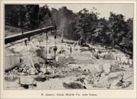
“Twelve vertical stack kilns with a reported maximum production of about 200 tons of lime per day are in operation at the plant. Coal is used for fuel and fed by hand to the kilns. The rock is loaded into the kilns from a charging platform which is virtually a continuation of the incline from the quarry. A spur from the incline permits the loading of waste rock, and rock not suited for high-grade lime, directly into open cars below. This material is used for various purposes from agricultural limestone to flux and whiting.”
- Ste. Genevieve, Ste. Genevieve County, Missouri - the Bogy Sandstone Quarries (Sandstone) (The following information is from The Quarrying Industry of Missouri, by E. R. Buckley, Director and State Geologist, and H. A. Buehler, Missouri Bureau of Geology and Mines Vol. II, 2nd Series, 1904.)
“Formerly, a number of quarries were operated in the Aux Vases sandstone, about four miles south of Ste. Genevieve. Large quantities of this stone were used in the abutments of the Eads bridge, at St. Louis ; in the Iowa State Capitol, at Des Moines ; and in the Equitable and McLean buildings in St. Louis. At one time the Richardson quarry, located in the United States Survey 307, T. 37, R. 9 E., and the Bogy quarries, located in the United States Survey No. 3221, T. 37, R. 9 E., were operated on an extensive scale. The former employed from 400 to 500 men and the latter from 300 to 400....”
- Ste. Genevieve County, Missouri - the Bogy Sandstone Quarries (Sandstone), historical quarry (location) (from Brainy Geography)
- Ste. Genevieve County/Area, Missouri - the Bussen Quarry (Limestone) (from Geology of Ste. Genevieve County, Missouri, by Stuart Weller and Stuart St. Clair, Vol. XXII, Second Series, Missouri Bureau of Geology and Mines, Rolla, Missouri, 1928. Used with permission.)
“Bussen Quarry. This quarry is located in the NE. ¼ sec. 12, T. 38 N., R. 9 E., on the north side of Lower Frenchman Hollow. The lower part of the Spergen and the upper part of the Warsaw formations are exposed in the working face, 125 feet long by 60 feet high, where the following section was measured:
Section exposed in Bussen Quarry, NE. ¼ sec. 12, T. 38 N., R. 9 E.
Overburden, red cherty soil - 1 (feet thick)
Spergen formation:
1. Limestone, light gray, crystalline, fossiliferous, heavy and cross-bedded, weathers light-gray and in thin beds - 10 - 25 (feet thick).
2. Limestone, yellow, crystalline, fossiliferous, argillaceous, in west part of face appears to be absent, the position being represented by 3-5 feet of red mud, apparently filling solution channel - 3- to 5 (feet thick).
3. Limestone, bluish-gray, finely crystalline, fossiliferous - 8 (feet thick).
4. Limestone, yellow, fine-grained, fossiliferous - 3 (feet thick).
5. Limestone, light bluish-gray, to brown, fine-grained to finely crystalline, fossiliferous. Heavy bedded but weathering in thin beds. Some phases show thin darker colored streaks of crystalline calcite parallel to bedding - 12 (feet thick).
6. Limestone, yellow, crystalline soft, called ‘sand’ by workmen - 5 (feet thick).
7. Shale, dark blue-gray, calcareous, thick-bedded but weathers into thin platy slabs, and to a buff colored clay. 1 foot exposed in face; and at least 5 feet, west of quarry in hollow - 1- to 5 (feet thick).
“The top of the quarry face slopes rapidly to the west from the bluff facing Mississippi River toward the small valley joining the hollow from the north. As a result the workings which have been continued west and into this valley are in the lower limestones of the above section. Higher up the valley, shales of the Warsaw formation are well exposed, the southeast dip, however, results in exposing only one foot in the main working face. Joints are prominent in the upper part of the face, some of these have been enlarged by solution, and filled with mud. Along the east end of the quarry, for a distance of five feet, the face is marked by a series of vertical joints, giving the rock a sheeted appearance.
“Drilling is done with pneumatic jack-hammer drills, the holes being loaded and shot with dynamite. Care is exercised in shooting to eliminate spalls, for which there is no sale. All the rock quarried is used in improvement work along the Mississippi River, the chief use being for riprap. The stone is hauled by trucks to the barge landing on the river.”
- Ste. Genevieve County/Area, Missouri - the Consolidated Marble Quarries Company Quarry on Peter Weiler’s Farm (from Geology of Ste. Genevieve County, Missouri, by Stuart Weller and Stuart St. Clair, Vol. XXII, Second Series, Missouri Bureau of Geology and Mines, Rolla, Missouri, 1928. Used with permission.)
“Consolidated Marble Quarries Company. This quarry is located at Marlo Switch, on the Missouri-Illinois Railroad, in the SW. ¼ sec. 36, T. 38 N., R. 8 E., on the farm of Peter Weiler. Prior to the beginning of operations in 1922, a diamond drill hole was put down, penetrating the Kimmswick limestone of Ordovician age. The Kimmswick at this place is white to light gray, very crystalline, fossiliferous. Along joint planes and solution channels the stone has a light brown color. It is reported to take a good polish. The face developed is 18 feet high. Just below the red, cherty clay overburden the rock is cut by many joints and cracks, enlarged by solution, and the rock has been weathered into knobs. Jointing is a prominent feature in this quarry, the directions being northeast-southwest and northwest-southeast; the former are the most prominent, and with the other set have cracked the stone into rectangular blocks. The lime has undergone considerable solution along these openings, which vary in width from one foot to five feet, the last mentioned being a prominent solution channel in the south part of the quarry.
“As a result of the jointing and subsequent solution of the limestone along these structures, a considerable quantity of stone was discarded as waste, and after operating about one year the quarry was closed. The property is equipped with a power plant, channeling machines, and a steel derrick. Attempts have been made recently to reopen the quarry.”
- Ste. Genevieve (south of), Missouri - the County Limestone Quarry (Marble/Limestone) (The following information is from The Quarrying Industry of Missouri, by E. R. Buckley, Director and State Geologist, and H. A. Buehler, Missouri Bureau of Geology and Mines Vol. II, 2nd Series, 1904.)
“This quarry, which is located one mile south of Ste. Genevieve, has been worked intermittently during the last four years. It is located on land owned by Peter Schneider of St. Louis. The entire output is crushed rock, used in the building of macadam pavements. The following is a description of the beds from top to bottom:
11 ft. - Bluish gray, finely crystalline limestone. Splits into thin beds when blasted.
1 ft. 2 in. - Solid, fine grained, fossiliferous, gray limestone.
1 ft. - Solid bed of compact, bluish gray limestone. Separated from the bed above by two inches of shale.
6 ft. - Finely crystalline, blue limestone, splits into beds from two to four inches in thickness. Thin seams of shale occur along the bedding planes.
“Two sets of joints about twenty feet apart strike respectively N. 28° E. and N. 57° W.
“This stone has been quarried at a number of different places south of the city and used as a road metal. These quarries are opened up at intervals so that it will not be necessary to haul the stone very far.”
- Ste. Genevieve Area, Missouri - the Egyptian Marble Company’s Marble Quarry (Marble/Limestone) (The following information is from The Quarrying Industry of Missouri, by E. R. Buckley, Director and State Geologist, and H. A. Buehler, Missouri Bureau of Geology and Mines Vol. II, 2nd Series, 1904.)
“In 1892 the Egyptian Marble Company began to develop the marble deposits in the United States Surveys 2074, 2083, 3164, T. 37, R. 8 E., between the upper tributaries of the Aux Vases and Saline creeks. Development work was carried on until March, 1893, since which time nothing has been done. This company made several small openings. The largest has a rather irregular shape approximating 50 feet square by 25 feet in depth. The following is a description of the beds from top to bottom:
5-7 ft. - Clay stripping.
4 ft. - Finely crystalline, mottled gray limestone.
6 ft. - Red and green shale, having a variegated color and containing calcareous concretions.
6 ft. - Variegated red and gray, finely crystalline, mottled marble. Very brittle.
7 ft. - Finely crystalline, yellowish magnesian limestone.
“The limestone in this quarry is all finely crystalline and contains narrow seams of calcite. It is brittle and must be handled very carefully to prevent breaking. It takes a fairly good polish and has been used for table tops and interior decorations to buildings.
“The quarry contains a very high percentage of unsalable stone, on account of which it cannot be worked profitably.”
- Ste. Genevieve, St. Genevieve County, Missouri - the Holcim (US) Inc. Quarry & Cement Plant (present day company) (history and photograph)
According to this article on the web site, Holcim (US) Inc. broke ground for their new plant and quarry along the Mississippi River. The first of two silos were completed at the plant on December 22, 2006. “ The Plant is due to be completed in 2009.”


 |
 |
 |
“Elevator lobby of Federal Trust Company building, Newark, New Jersey. The marbles shown here are Napoleon Gray, St. Geneieve and Black and Gold.” |
“Banking room of the Federal Trust Company building, Newark, New Jersey, showing floor, counters, walls and bases of Napoleon Gray and St. Genevieve and Black and Gold Marbles. Architects: Dennison & Hirons.” |
“A corner in marble in the banking room of the Federal Trust Company Building, Newark, New Jersey. The marbles are Napoleon Gray, St. Genevieve and Black and Gold.” |

Ste. Geneveive County Quarries continued on Page 1 2
Commercial use of material within this site is strictly prohibited. It is not to be captured, reworked, and placed inside another web site ©. All rights reserved. Peggy B. and George (Pat) Perazzo.