
Quarries in Missouri & Quarry Links, Photographs, and
Articles
St. Louis – Broderick thru Bussen
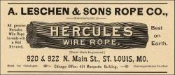
- St. Louis, Missouri - the Broderick & Bascom Rope Co. (Advertisement) (from Stone:
An Illustrated Magazine,
November 1892, Vol. V., No. VI, pp. xvi. The same or similar advertisement
also ran in the following issues of Stone:
February 1893, Vol. VI, No. III, pp. xii; March 1893, Vol. VI, No. IV, pp. xiv;
April 1893, Vol. VI, No. V., pp. xviii; May 1893, Vol. VI, No. VI, pp. xxiii
and xxv; December 1896, Vol. XIV, No. 1, pp. xxv; February 1897, Vol. XIV, No.
3, pp. xvi; April 1897, Vol. XIV, No. 5, pp. xiii; May 1897, Vol. XIV, No. 6,
pp. xvi; December 1897, Vol. XVI, No. 1, pp. xvi; January 1898, Vol. XVI, No.
2, pp. xxiv; February 1898, Vol. XVI, No. 3, pp. xxiv; March 1898, Vol. XVI,
No. 4, pp. 397; April 1898, Vol. XVI, No. 5, pp. xxvi; May 1898, Vol. XVI, No.
6, pp. xxiv; January 1899, Vol. XVIII, No. 2, pp. 83; February 1899, Vol. XVIII,
No. 3, pp. 81; March 1899, Vol. XVIII, No. 4, pp. 167; April 1899, Vol. XVIII,
No. 5, pp. 26, June 1899, Vol. XIX, No. 1 pp. 67; July 1899, Vol. XIX, No. 2,
pp. 169; August 1899, Vol. XIX, No. 3, pp. 108; September 1899, Vol. XIX, No.
4, pp. 308; October 1899, Vol. XIX, No. 5, pp. 489; November 1899, Vol. XIX,
No. 6, pp. 516; January 1902, Vol. XXIV, No. 1, pp. after pp. 75; February 1902,
Vol. XXIV, No. 2, pp. 175; March 1902, Vol. XXIV, No. 3, pp. 275; April 1902,
Vol. XXIV, No. 4, pp. 375; May 1902, Vol. XXIV, No. 5, pp. 475; June 1902, Vol.
XXIV, No. 6, pp. 575; July 1907, Vol. XXVII, No. 2, pp. 151; August 1907, Vol.
XXVIII, No. 3, pp. 199; September 1907, Vol. XXVIII, No. 4, pp. 303; November
1907, Vol. XXVIII, No. 6, pp. 351; December 1907, Vol. XXVIII, No. 7, pp. 437;
January 1908, Vol. XXVIII, No. 8, pp. 483; February 1908, Vol. XXVIII, No. 9,
pp. 571; April 1908, Vol. XXVIII, No. 11, pp. 621; May 1908, Vol. XXVIII, No.
12, pp. 665; in addition to the issues presented below.)

Broderick & Bascom Rope Co., St. Louis, MO.
Wire Rope
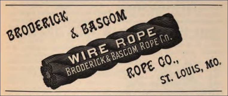
- St. Louis, Missouri - Broderick & Bascom Rope Co. (Advertisement) (from Stone Magazine, December, 1895, Vol. XII, No. 1, pp. 89)
Broderick & Bascom Rope Co., St. Louis, MO
Manufacturers of ‘Power’ Rope. And All Grades of Iron and Steel Ropes and Street-Railway Cables,.
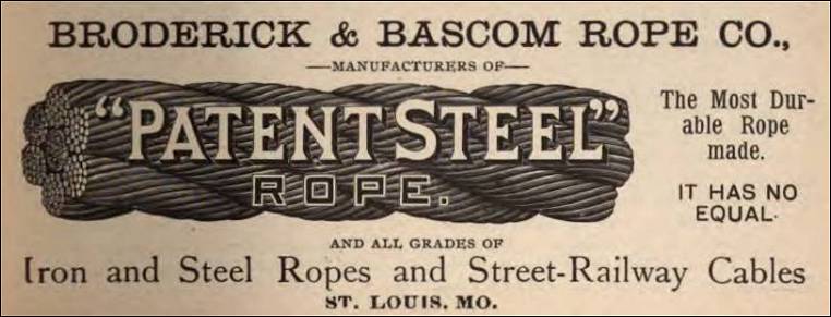
- St. Louis, Missouri - Broderick & Bascom Rope Co. (Advertisement ) (from Stone: An Illustrated Magazine, December 1897, Vol. XVI, No. 1, pp. xvi)

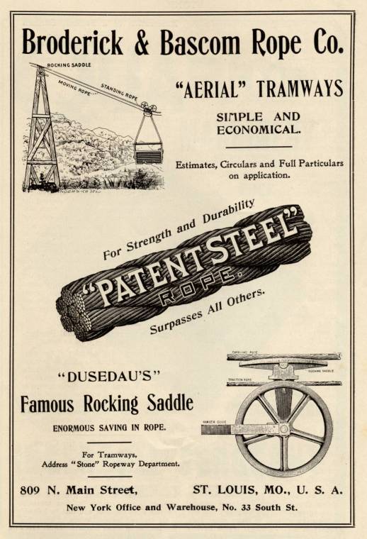
- St. Louis, Missouri – Broderick & Bascom Rope Co. (The following information is from an advertisement in Stone: An Illustrated Magazine Devoted to Stone, Marble, Granite, Slate, Cement, Contracting and Building, Vol. XXIV, No. 1, January, 1902, Stone Publishing Co., New York, pp. 75.)

Broderick & Bascom Rope Co., 809 N. Main Street, St. Louis, MO., U.S.A.
New York Office and Warehouse, No. 33 South St.
“Aerial” Tramways – Simple and Economical. Estimates, Circulars and Full Particulars on application. For Strength and Durability. “Patent Steel” Rope. Surpasses All Others.“Dusedau’s” Famous Rocking Saddle. Enormous Saving in Rope. For Tramways, Address “Stone” Ropeway Department.
- St. Louis, Missouri - Broderick & Bascom Rope Co. (Advertisement ) (from Stone: An Illustrated Magazine, December 1897, Vol. XVI, No. 1, pp. xvi)
- St. Louis, Missouri - Broderick & Bascom Rope Co.
(Advertisement) (from Mines and Minerals, A
Mining and Metallurgical Journal, June, 1902, Vol. XXII, No.
11, inside front cover)

Broderick & Bascom Rope Co., Sole Manufacturers of “Patent Steel” Rope
St. Louis, MO. - Established 1875. New York Office and Warehouse, 33 South Street.
The Most Durable Rope Made. It Has No Equal.
Scranton Supply & Machinery Co., Agts, Scranton, Pa. All sizes of Ware Rope carried in stock.
Somers, Fitlier & Clarke, Ltd., Agts., Pittsburg, Pa. All sizes of Wire Rope carried in stock.
-
St. Louis, Missouri – Broderick & Bascom Rope Co. (“Wire Rope Nineteen Centuries Old” in Pompeii, Italy, “Wire Rope Nineteen Centuries Old,” Mine and Quarry, Sullivan Machinery Company, Chicago, Illinois
December 1903, pp. 125-127. The Broderick & Bascom Rope Co. is mentioned in this article.)
(excerpts from the article)
“In the issue of Stone for December, 1895, there was printed an abstract of the inaugural lecture of Prof. Goodman, of the engineering department of the Yorkshire College, Leeds, Eng. Prof Goodman stated that he had recently visited Pompeii, and had been greatly interested in the many evidences shown of the extreme ingenuity of the ancient Romans as mechanics. He described the paving and water supply of Pompeii, which was buried under showers of ashes and
mud in the excavators….”
“Some time ago the Broderick & Bascom Rope Company, of St. Louis, wrote to the editor of Stone for information concerning the mention of this wire rope, which was believed to be the earliest reference to it in America….”
- St. Louis, Missouri - Broderick & Bascom Rope Co. (Advertisement) (from Stone Magazine, December, 1895, Vol. XII, No. 1, pp. 89)
- St. Louis, Missouri - the Lawrence Bruce Quarry (listed in The Mine, Quarry and Metallurgical Record of the United States, Canada, and Mexico, The Mine and Quarry News Bureau, Chicago, Ill., 1897)
- St. Louis, Missouri - the Bruce & Sheahan Quarry (listed in The Mine, Quarry and Metallurgical Record of the United States, Canada, and Mexico, The Mine and Quarry News Bureau, Chicago, Ill., 1897)
- St. Louis, Missouri - the Bussen Limestone Quarry (Limestone) (The following information is from The Quarrying Industry of Missouri, by E. R. Buckley, Director and State Geologist, and H. A. Buehler, Missouri Bureau of Geology and Mines Vol. II, 2nd Series, 1904.)
“This quarry, which is located one and one-half miles south of Jefferson Barracks, is owned and operated by Albert Bussen. It is situated on one of the river bluffs and has an east face 300 feet long and forty feet high. The rock is a finely crystalline, gray limestone belonging to the St. Louis formation. It occurs in beds from three inches to two feet in thickness. Small nodules of chert occur in the lower and upper beds of the quarry, but they are not sufficiently abundant to injure the stone for furnace flux, for which the stone is quarried exclusively.
“A second opening is being made on the south side of a small ravine just south of the present quarry. An abandoned opening, about the size of one now being worked, is located on the north side of the ravine.”
- St. Louis, St. Louis County, Missouri - Bussen Quarries,
Inc. Limestone Quarry (Limestone) (from Limestones
and Dolomites in the St. Louis Area, Report of Investigations
No. 5, by Norman S. Hinchey, R. B. Fisher, and W. A. Calhoun,
State of Missouri Department of Business and Administration, Division
of Geological Survey and Water Resources, Rolla, Missouri, 1947.
Used with permission.) (For an explanation of the study of
which this section is a part, see: St. Louis Area
of Missouri - Limestones and Dolomites in the St. Louis Area (St.
Louis County, Jefferson County, and Lincoln County)
Locality G (Field Descriptions and Analytical Information)
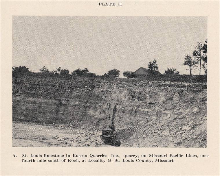
“Remarks. The exposures sampled at this locality lie in the face of the north quarry operated by Bussen Quarries, Inc.
“Location: In the SW ¼ NW ¼ sec. 7, T. 43 N., R. 7 E., St. Louis County, Missouri. This quarry is at Bussen siding on the Missouri Pacific Lines, about one-fourth mile south of Koch, Missouri, on the west bank of the Mississippi River.
“Transportation. The quarry is served by a siding of the Missouri Pacific Lines, and barge-loading facilities on the Mississippi River are at hand. Hard-surfaced roads into the quarry serve trucking operations.
“Elevation. The track level of the Missouri Pacific Lines at the quarry is approximately 415 feet above sea level, and the floor of the north quarry (in 1946) had an elevation of 411 feet. Elevations which are given in the description of the geologic section refer to these datum points.
“Stratigraphic Position. All of the beds in this quarry section are in the St. Louis formation of Mississippian age. It is estimated that the floor of this quarry is approximately 125 to 150 feet above the base of the St. Louis formation.
“Samples. Eighteen samples, G-1 to G-18, inclusive, were taken at this locality. It should be noted that the 9 samples taken at locality J and labeled J-1 to J-9, inclusive, are from the sequence of beds that immediately underlie these beds at locality G. Locality J is approximately one-fourth mile south of locality G in another part of this Bussen quarry.
“Geologic Section. A description of the sequence of strata, from top to bottom, at this locality is as follows:
16. Surficial material, made up of soil, loess, and clay to top of bluff. Elevation, 476 to approximately 500 feet. Thickness is estimated at 10 feet to 25 feet.
15. Limestone, in vertical bluff face making the upper part of the quarry; inaccessible at the time the section was examined. Not seen in detail. Elevation, 446 to 476 feet. Thickness estimated at 25 to 30 feet.
14. Limestone, dark gray, irregularly laminated with fine laminae. A rather distinct local ‘marker’ in the quarry when taken with the bed below it (No. 13). Not sampled. - 1 foot.
13. Limestone and cherty or flinty limestone, light gray with white and dark gray chert in appreciable amounts, dense. The ‘flint-bed’ of the quarrymen. Contains a silicified zone of the coral, Lithostrotionella, near the top. Variable in character and chert content. Elevation, 440 ½ to 446 feet. Not sampled. - 4 ½ feet.
12. Limestone, gray, dense to lithographic, in beds from 3 to 8 inches thick with very thin clay partings; bedding irregular. Elevation, 439 to 440 ½ feet. Sample G-18 was taken at an elevation of 440 feet. - 1 ½ feet.
11. Limestone, dolomitic, buff and gray, dense; alternating layers of limestone and dolomitic limestone; locally weathered to a recess in the buff; thickens to the south. Elevation, 438 to 439 feet. Sample G-17 was taken at an elevation of 438 feet. - 1 foot.
10. Limestone, shaly limestone, and chert at top; gray, fine-grained. A massive bed with tight stylolitic partings at an elevation of 437 and 437 ½ feet. Elevation, 436 ½ to 438 feet. Sample G-16 was taken at an elevation of 437 feet. - 2 ½ feet.
9. Limestone, gray; texture varied; in beds from ½ to 1 foot thick; upper part finer-grained; upper ½ foot cherty; somewhat brecciated at an elevation of 434 feet. Elevation, 434 to 436 ½ feet. Samples were taken as follows: G-15 at an elevation of 435 ½; G-14 at 435; and G-13 at 434 feet. - 2 ½ feet.
8. Limestone, gray, fine-grained to medium-grained; a massive bed. Elevation, 431 ½ to 434 feet. Sample G-12 as taken at an elevation of 433 feet. - 2 ½ feet.
7. Limestone, gray, fine-grained. Elevation, 430 to 431 ½ feet. Sample G-11 was taken at an elevation of 431 feet. - 1 ½ feet.
6. Limestone, gray, fine-grained to medium-grained; in beds of 1 to 5 inches. Elevation, 428 to 430 feet. Sample G-10 was taken at an elevation of 429 feet. - 2 feet.
5. Limestone (may be slightly dolomitic and argillaceous at places); gray; texture varied; medium- to coarse-grained; shaly partings ½ foot and 2 ½ feet above base; a prominent ledge in the quarry. Elevation, 425 to 428 feet. Sample G-9 was taken at an elevation of 427 feet; G-8 was taken at 426 feet.
4. Limestone, impure and shaly, buff, fine-grained, poorly exposed. Elevation, 424 to 425 feet. Not sampled. - 1 foot.
3. Limestone, variable in color and texture, with a few chert lenses; coarse crystalline limestone interbedded, with beds 1 inch to 1 foot thick. Few lenses of chert at an elevation of 420 to 421 made less than 5 percent. Elevation, 419 to 424 feet. Samples were taken as follows: G-7 at an elevation of 423 feet; G-6 at 422; G-5 at 420 feet. - 5 feet.
2. Limestone, buff-gray and gray, medium-grained to dense; a few scattered calcite crystals; massive bed; zone of Lithostrotion proliferum 6 inches below top. Elevation, 414 ½ to 419 feet; G-3 was taken at 417 feet. - 4 ½ feet.
1. Limestone, impure, gray, fine-grained; small nodules of chert at places makes up 5 percent of the upper 1 foot; thin, buff, argillaceous laminae are irregularly spaced vertically through the bed; extends down to present quarry floor (1946). Elevation, 411 to 414 ½ feet. Sample G-2 was taken at an elevation of 414 feet; sample G-1 was taken at an elevation of 413 feet. - 3 ½ feet.
Base of section sampled.
Analytical Information on Limestone Samples of St. Louis Formation At Locality G. The chemical analyses of the 18 samples, G-1 to G-18, inclusive, are as follows:
Analyses of Samples at Locality G 
Plate II. A. St. Louis limestone in Bussen Quarries, Inc., quarry, on Missouri Pacific Lines, one-fourth mile south of Koch, at Locality G, St. Louis County, Missouri. 
Plate II. B. St. Louis limestone at Bussen Quarries, Inc., Locality J, St. Louis County, Missouri. 
- St. Louis, St. Louise County, Missouri - Bussen Quarries, Inc. Limestone Quarry (located 1/4th mile south of Locality G above) (Limestone) (from Limestones and Dolomites in the St. Louis Area, Report of Investigations No. 5, by Norman S. Hinchey, R. B. Fisher, and W. A. Calhoun, State of Missouri Department of Business and Administration, Division of Geological Survey and Water Resources, Rolla, Missouri, 1947. Used with permission.) (For an explanation of the study of which this section is a part, see: St. Louis Area of Missouri - Limestones and Dolomites in the St. Louis Area (St. Louis County, Jefferson County, and Lincoln County)
Locality J (Field Descriptions and Analytical Information)
“Remarks. The beds sampled at this locality represent a sequence of strata lying immediately beneath the beds sampled at locality G. Locality J is near the south end of the open quarry at Bussen, approximately one-fourth mile south of and up the dip from locality G. If projected to the north, the top bed at locality J would make the quarry floor at locality G. Thus, bed No. 7, elevation 430 feet, at J is the bed which makes the quarry floor, elevation 411 feet, at locality G.
“Location: In the NW ¼ SW ¼ sec. 7, T. 43 N., R. 7 E., St. Louis County, Missouri. The samples were taken from the freshly quarried bluff along the Missouri Pacific Lines, about 1,000 feet south of the crusher and storage plant of Bussen Quarries, Inc. The section sampled represents the lower beds near the north entrance of the tunnel quarry.
“Transportation. As in the case at locality G, the site of locality J is served by the Missouri Pacific Lines, and barge-loading facilities are available on the Mississippi River at the quarry. All-weather roads lead to the quarry.
“Elevation. The datum of reference at this site is the track level of the Missouri Pacific Lines, approximately 415 feet above sea level. Elevations given in the geologic section refer to that datum.
“Stratigraphic Position. These beds are immediately subjacent to the beds sampled at locality G. They lie in the St. Louis formation (Mississippian) at a horizon estimated to be approximately 115 to 140 feet above the base of that formation.
“Samples. Nine samples, J-1 to J-9, inclusive, were taken at this locality.
“Geologic Section. The description of the beds sampled, from top to bottom, at locality J is as follows:
8. A sequence of strata to top of the bluff face; not examined in detail here. See locality G. - -------
7. Dolomite, buff or tan, earthy, weathered to a finely porous ‘punky’ rock. Contains about 30 percent brown and red chert in flat nodules at top and at base. Makes a distinct light-colored band in the tunnel quarry and is the floor rock of the north quarry at Bussen. Thickness varies between 4 and 7 inches here. Not sampled - -------
6. Limestone, gray, finely crystalline to medium-grained; tight stylolitic partings; a fairly massive bed with some dark gray chert at an elevation of 427 ½ feet. Elevation, 426 ½ to 429 ½ feet. Sampled as follows: J-9 was taken at an elevation of 429 feet; J-8 was taken at an elevation of 427 feet. - 3 feet.
5. Limestone and argillaceous limestone, gray; in 3 thin beds; lower 5-inch bed is nodular-conglomeratic; upper 2 beds are dense to lithographic; variable. One-inch partings of green shale separate the 3 beds. Elevation, 425 to 426 ½ feet. Sample J-7 was an aggregate sample of the varied lithologies. - 1 ½ feet.
4. Limestone, argillaceous and cherty; variable, with chert making about 5 percent; gray, fine- to medium-grained. Elevation, 423 ½ to 425 feet. Sample J-6 was taken at an elevation of 425 feet, and J-5 at 424 feet. - 1 ½ feet.
3. Limestone, dark gray to gray; texture varies, fine- to coarse-grained; banded calcareous algae (?) gives conglomeratic appearance to middle 4 inches and to upper 3 inches; an occasional 1-inch parting at top. Elevation, 422 to 423 ½ feet. Sample J-4 is an average sample of the varied Lithology, taken at an elevation of 423 feet. - 1 ½ feet.
2. Limestone and cherty limestone, gray, fine-grained; chert is light gray to whitish-gray, banded, and makes about 5 to 10 percent of the rock; a poorly bedded ledge; upper 1 foot is nodular limestone with ¼- to ½-inch calcareous algae (?); lower 2 inches is very siliceous; a variable sequence. Elevation, 418 to 422 feet. Sampled as follows: J-3 was taken at an elevation of 422 feet, and J-2 was taken at 420 feet. - 4 feet.
1. Limestone, gray, fine-grained to dense, overlain by 1 inch of shaly limestone. Elevation, 417 to 418 feet. Lower 2 feet of section, 415 to 417 feet, is covered with spalls. Sample J-1 was taken at an elevation of 418 feet. - 1 foot.
(Covered interval) 2 feet.
Base of section sampled is track level of Missouri Pacific Lines.
Analytical Information on Limestone Samples of St. Louis Formation At Locality J. The chemical analyses of the nine samples from locality J are as follows:
Analyses of Samples at Locality J 
- St. Louis County, Missouri - Bussen Quarries Inc. Abandoned Bluff Limestone Quarry (Limestone) (from Limestones and Dolomites in the St. Louis Area, Report of Investigations No. 5, by Norman S. Hinchey, R. B. Fisher, and W. A. Calhoun, State of Missouri Department of Business and Administration, Division of Geological Survey and Water Resources, Rolla, Missouri, 1947. Used with permission.) (For an explanation of the study of which this section is a part, see: St. Louis Area of Missouri - Limestones and Dolomites in the St. Louis Area ( St. Louis County, Jefferson County, and Lincoln County )
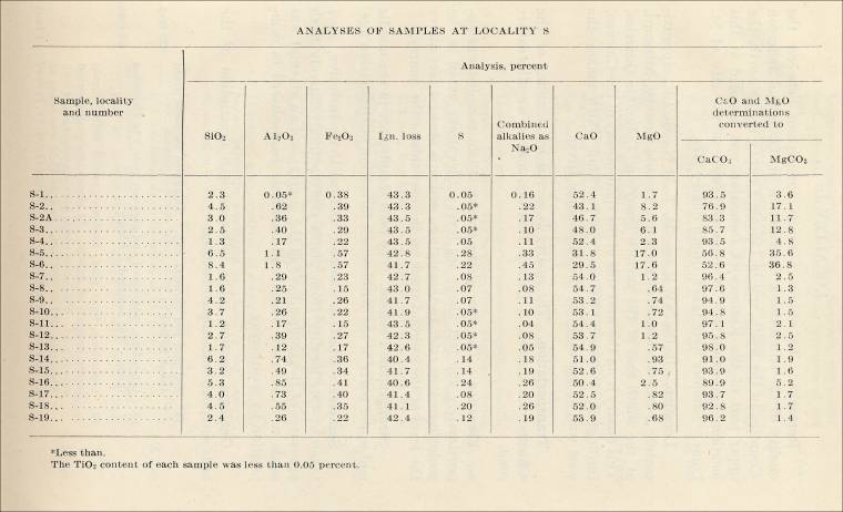
Locality S (Field Descriptions and Analytical Information)
“Remarks. Samples from this locality were taken from the upper part of the face of an abandoned quarry owned by Bussen, Quarries, Inc.
“Location. In SE ¼ SW ¼ Sec. 35, T. 43 N., R 6 E., in St. Louis County, Missouri, at an abandoned quarry in the west bluff of the Mississippi River, adjacent to the right-of-way of the Missouri Pacific Lines. This place is approximately one-fourth mile south of White House station on the railroad.
“Transportation. The Missouri Pacific Lines and Mississippi River afford transportation facilities at this location.
“Elevation. An upper bench in the south part of this quarry is the base of the section sampled. It lies approximately 450 feet above sea level. This datum is about 35 feet above the track level of the Missouri Pacific Lines and about 37 feet above the floor of the lower part of this abandoned quarry. Elevations noted in the geologic section refer to these datum points.
“Stratigraphic Position. The base of the section The beds sampled are in the lower part of the St. Louis formation (Mississippian). The base of the section sampled is estimated to be 75 feet above the contact between the St. Louis formation and the subjacent Spergen (Salem) formation, also of Mississippian age.
“Samples. Twenty samples were taken at this locality and are designated serially as S-1 to S-19, inclusive, with an additional sample designated S-2A.
“Geologic Section. The sequence, from top to bottom, is as follows:
18. Soil, clay, and loess; thickness variable - 25 feet.
17. Limestone, variable, gray, crystalline to sublithographic; some cherty and some shaly beds; weathered. Elevation, 483 to 495 feet - 12 feet.
16. Limestone, gray; texture varies from fine-grained to somewhat brecciated; tight shaly partings at elevations 480 ½, 481, and 482 feet. Top makes top of highest bench at southwest end of upper quarry. Elevation, 479 ½ to 483 feet. Samples were taken as follows: Sample S-19 was taken at an elevation of 482 feet; S-18 at 481; and S-17 at 480 feet - 3 ½ feet.
15. Limestone, gray and brownish-gray fine-grained to finely crystalline and finely brecciated, wavy-laminated; upper 3 inches contains blue-gray shaly limestone. Elevation, 477 ½ to 479 ½ feet. Sample S-16 was taken at an elevation of 479 feet - 2 feet.
14. Limestone, gray and flecked with brown, medium-grained; in 3 beds of variable thickness, separated by partings of gray shaly limestone and limy shale. Elevation, 476 to 477 ½ feet. Sample S-15, taken at an elevation of 477 feet, was an aggregate of these beds- 1 ½ feet.
13. Limestone, gray, medium-grained to crystalline, more dense in upper 1 foot which is finely brecciated at places. Elevation, 473 to 476 feet. Sample S-14 was taken at an elevation of 475 feet; S-13 was taken at an elevation of 474 feet - 3 feet.
12. Limestone, gray-brown or drab, fine-grained. Elevations, 472 ½ to 473 feet. Sample S-12 was taken at an elevation of 473 feet - ½ foot.
11. Limestone, similar to No. 10 below; a massive bed which is parted at places into 2 and 3 beds where shaly partings are present; lower 1 foot contains some coarse brown crystalline areas and some magnesian areas. Elevation, 469 to 472 ½ feet. Sample S-11 was taken at an elevation of 472 feet; S-10 was taken at an elevation of 470 feet - 3 ½ feet.
10. Limestone, gray, medium-grained and somewhat crystalline, flecked at places with brown calcite crystals; a massive bed with some breccia-conglomerate in lower 6 to 8 inches; shaly at base, locally cross-bedded where weathered; top is an uneven, wavy 1- to 2-inch bed of limy, gunmetal gray shale. Elevation, 465 to 469 feet. Sample S-9 was taken at an elevation of 467 feet - 4 feet.
9. Limestone, like No. 8 below, but somewhat brecciated and fine-grained; sublitholographic in places in upper 6 inches. Elevation, 463 to 465 feet. Sample S-8 was taken at an elevation of 465 feet - 2 feet.
8. Limestone, gray, fine-grained to lithographic, weathered white; ‘paint rock’; a single bed; somewhat brecciated. Elevation, 462 to 463 feet. Sample S-7 was taken at an elevation of 462 feet - 1 foot.
7. Limestone, magnesian, gray and buff-gray, slightly argillaceous in part with ‘floating’ grains of calcite in the mass. An irregular bed. Elevation, 461 ½ to 462 feet. Not sampled - ½ foot.
6. Limestone, magnesian, gray and buff-gray, fine-grained; in 2 and 3 thin beds at places separated by shaly partings. Elevation, 460 to 461 ½ feet. Sample S-6 was taken at an elevation of 461 feet - 1 ½ feet.
5. Limestone, magnesian, gray, medium-grained; upper 1 foot laminated with wavy laminae which are alternately gray and drab. Elevation, 458 ½ to 460 feet. Sample S-5 was taken at an elevation of 460 feet; S-4 was taken at an elevation of 459 feet - 1 ½ feet.
4. Limestone, with some chert, drab-gray, fine-grained; a few nodules and lenses of chert; irregularly bedded; thickens and thins and lenses and splits; to the north it grades downward into No. 3 and No. 2 and makes the upper part of No. 2. Elevation, approximately 457 ½ to 458 ½ feet. Sample S-3 was taken at an elevation of 458 feet - 1 foot.
3. Limestone and shaly and argillaceous limestone; drab-gray, weathered to buff; fine-grained. irregular bed; thickens and thins laterally from 1 ½ feet to ½ foot within short lateral distance. Pinched out entirely at places. Elevation, 456 to 457 ½ feet. Not sampled - 1 ½ feet.
2. Limestone, gray, fine-grained; a massive bed immediately above the quarry floor (bench); upper ½ foot contains argillaceous material in lenses; top is an undulatory bed plane. Elevation, 450 to 456 feet. Samples were taken as follows: S-2A was taken at an elevation of 455 feet; S-2 at an elevation of 455 feet, but 75 feet south of S-2A; S-1 at an elevation of 452 feet - 6 feet.
1. Quarry floor (bench); a gently undulatory bedding plane; chert in large flat subcircular nodules and masses of irregular shape. Not sampled - ---
“Note: Below this bench in the quarry (No. 1) the lower part of the main quarry lies to the north and presents an additional 37 feet of beds below No. 1. These lower strata are of limestone and shaly and cherty limestone which extends down to the level of the Missouri Pacific Lines.
Analytical Information on Limestone Samples of St. Louis Formation At Locality S. The chemical analyses of the 20 samples taken from the lower part of the St. Louis formation at locality S are as follows:
Analyses of Samples at Locality S. 
- St. Louis, Missouri - Bussen Quarries, Inc. (present-day company) (photographs) According to the web site, tours are available.
The Quarries - Crushed Limestone
The Bussen family has been mining crushed limestone to service the St. Louis area aggregate needs since 1882. According to the web site, this company is one of the largest crushed stone producers in the Midwest area. Their product is used for such uses as building roads and highways, soil erosion, homes, schools, office buildings, and hospitals.
Quarry Locations
Jefferson Barracks Plant, 5000 Bussen Road, St. Louis, MO 63129.
“The ‘original’ quarry site with over 500 acres, began in 1882 making crushed stone for the Corps of Engineers. It is located on the Mississippi river in south St. Louis county, just 1/4 mile south of the Jefferson Barracks bridge. Easy truck access is available off I-255 and Koch road. In addition to our mining operation, we also have a Mississippi river sand operation, a barge terminal, and Bussen Underground Warehouse.
Antire Quarry Plant, 6800 Bussen Road, Eureka, MO 63025.
“This large acreage site began in 1957 to service the west county area. Our Antire plant is conveniently located off 1-44 and Antire road. We operate a stationary and portable plant to keep up with this fast growing area.
Trautman Quarry Plant, 8799 Trautman Quarry Road, Pevely, MO 63070.
“The Bussen family bought this large site from the Trautman family years ago to service the Jefferson county area. The Trautman plant is located just off I-55 and highway Z in Pevely, MO.”


| “Wire rope found at Pompeii, now in Naples museum.” (Pompeii, Italy) from “Wire Rope Nineteen Centuries Old,” Mine and Quarry, December 1903, pp. 126) |  |


Commercial use of material within this site is strictly prohibited. It is not to be captured, reworked, and placed inside another web site ©. All rights reserved. Peggy B. and George (Pat) Perazzo.