
Quarries in Maine & Quarry Links, Photographs, and
Articles
(Continued)
-
Calais, Washington County, Maine - the Beaver Lake
Quarry, from The Commercial Granites of New England,
Bulletin 738, by T. Nelson Dale, U. S. Geological Survey,
1923.
This quarry was "in the town of Calais, near the north end of Beaver Lake, 4 miles west of Red Beach village." The operator was the Maine Red Granite Co. of Red Beach. Rock from the quarry ("black granite") was reportedly "a mica-quartz diorite of general dark-gray shade (black mottled with white and gray) and of coarse to medium porphyritic texture."
The Beaver Lake Quarry opened in 1885. In 1905 the quarry measured 250 feet north-northeast to south-southwest by 75 feet across and had a working face on the east of 30 feet in height. Transport of the stone was by cartage of 4 miles to the company's cutting mill at Red Beach and then further cartage of one-fourth mile to the wharf on St. Croix River. At the time of the report, the quarry was idle.
The product from the quarry was used entirely for monuments, and the Soldiers' Monument at Calais is an example.
- Calais, Washington County, Maine - the Beaver Lake Granite Quarry (dark gray color) Structures in which this stone was used include: Four fluted columns (22' by 3' for courthouse), Marquette, Michigan; and Soldiers Monument, Calais, Maine.(For a more detailed description of granite and location of quarry, see Maine Quarries and Prospects published by the Maine Geological Survey, written by M. B. Austin and A. M. Huseey, II, John R. Rand, State Geologist, May 1, 1958, pp. 7.)
-
Calais, Washington County, Maine – the Gardner’s Prospect,
from The Commercial Granites of New England, Bulletin 738, by T.
Nelson Dale, U. S. Geological Survey, 1923.
This quarry was “in the town of Calais, on the St. Croix River, 6 miles south of Calais, north of road to Redbeach.” The owner was Lorenzo Gardner of Calais, Maine. Rock from the quarry (“black granite”) was “a quartz diorite of very dark gray (not bluish) shade and fine, even-grained texture. It takes a high polish, and the hammered and cut surfaces are very light. The stone is suitable for monumental work. Dr. George Otis Smith, who visited the Gardner prospects in 1903, states that ‘pink granite occurs intrusive in the dioritic rock in such a manner that both kinds of stone can be quarried from the same opening.’”
- Calais, Washington County, Maine - the Gardiner Black Granite Prospect (very dark gray color) Stone from this quarry was used for monumental work - locations not stated. (For a more detailed description of granite and location of quarry, see Maine Quarries and Prospects published by the Maine Geological Survey, written by M. B. Austin and A. M. Huseey, II, John R. Rand, State Geologist, May 1, 1958, pp. 15.) [Please note that in" The Commercial Granites of New England," by T. Nelson Dale, 1923, the name of this quarry was "Gardner's Prospect." See entry above.]
-
Calais, Washington County, Maine - the Maine Red Granite Co.'s
Quarry, from The Commercial Granites of New England, Bulletin
738, by T. Nelson Dale, U. S. Geological Survey, 1923.
This quarry was located "in the town of Calais, three-fourths mile west of Red Beach." The operator was the Maine Red Granite Co. of Red Beach, Maine. Granite from the quarry was reportedly a bright-pinkish-gray color with a medium texture. "This type of 'red granite' is the brightest of those occurring in Maine." Transport of the granite was by cart over half a mile to the wharf on St. Croix River at Red Beach. The company had a cutting and polishing works about one-fourth mile west of Red Beach..
The quarry had two openings. One was known as the "old quarry, and it was opened in 1876. The "new" opening was made in 1905 and measured about 150 feet square and had a depth from 20 to 50 feet. At the time of the report, the quarry was idle.
All of the granite from the Maine Red Granite Co. was used for monumental and ornamental work
- Calais, Washington County, Maine - the Maine Red Granite Company Quarry (bright pinkish color) Stone from this quarry was used for monumental and ornamental work - locations not stated. (For a more detailed description of the granite and location of quarry, see Maine Quarries and Prospects published by the Maine Geological Survey, written by M. B. Austin and A. M. Huseey, II, John R. Rand, State Geologist, May 1, 1958, pp. 20.)
-
Calais, Washington County, Maine - the Mingo-Bailey Quarry (#1),
from The Commercial Granites of New England, Bulletin 738, by T.
Nelson Dale, U. S. Geological Survey, 1923.
This quarry was "in the town of Calais, about 6 miles south of Calais, on the southwest side of the road to Redbeach, on the north side of an east-west ridge, near top." The operator was Mingo, Bailey & Co of Redbeach, Maine. Rock from the quarry ("black granite") was reportedly "almost black with a slight greenish tinge and of fine to medium even-grained ophitic texture." When the quarry was measured in 1905, the quarry was 50 by 15 feet and had a depth up to 20 feet. The sheets were about 10 feet thick. The stones were carted to the company's cutting shed near Redbeach on the St. Croix River. The Mingo-Bailey Quarry was only occasionally worked.
- Calais, Washington County, Maine - the Mingo, Bailey and Company Black Granite Quarry (almost black color with slightly greenish tinge) (For a more detailed description of the granite and location of quarry, see Maine Quarries and Prospects published by the Maine Geological Survey, written by M. B. Austin and A. M. Huseey, II, John R. Rand, State Geologist, May 1, 1958, pp. 21.)
-
Calais, Washington County, Maine - the Mingo-Bailey Quarry (2),
from The Commercial Granites of New England, Bulletin 738, by T.
Nelson Dale, U. S. Geological Survey, 1923.
This quarry was "in the town of Calais, 1 1/2 miles north-northwest of Red Beach." The operator was the Mingo, Bailey & Co. of Red Beach, Maine. Granite from this quarry was reportedly a dark-reddish color speckled with pale greenish and had a medium texture. Transport of the granite was by cart 1 1/2 miles to the wharf at Red Beach.
The quarry measured 25 feet square by 8 feet deep at the time of the report and was abandoned. The granite from this quarry was used entirely for monuments.
- Calais, Washington County, Maine - the Mingo, Bailey and Company Red Granite Quarry (dark reddish color speckled with pale green) Stone from this quarry was used for monuments - locations not stated. (For a more detailed description of the granite and location of quarry, see Maine Quarries and Prospects published by the Maine Geological Survey, written by M. B. Austin and A. M. Huseey, II, John R. Rand, State Geologist, May 1, 1958, pp. 21.)
-
Calais, Washington County, Maine - the Red Beach Granite Co.'s
Quarry, from The Commercial Granites of New England, Bulletin
738, by T. Nelson Dale, U. S. Geological Survey, 1923.
This quarry was "in the town of Calais, on Cooks Mountain, 8 miles southeast of Calais, about 1,000 feet southwest of road to Red Beach." The operator was the Red Beach Granite Co. of Red Beach, Maine. Granite from the quarry was reportedly a bright pinkish-gray color and had a medium texture. Transport of the granite was by cart over half a mile to the wharf on St. Croix River at Red Beach.
The Red Beach Granite Co.'s Quarry opened in 1895. At the time of the report, the quarry measured 50 by 25 feet and had a depth of 5 to 20 feet.
Granite from this quarry was used for buildings and monuments, and examples of the granite can be seen in the red granite in two corner wings of the American Museum of Natural History in New York; and the pedestal to General Grant's monument at Galena, Illinois.
- Calais, Washington County, Maine - the Red Beach Granite Company Quarry (bright pinkish color) (For a more detailed description of the granite and location of quarry, see Maine Quarries and Prospects published by the Maine Geological Survey, written by M. B. Austin and A. M. Huseey, II, John R. Rand, State Geologist, May 1, 1958, pp. 25.)
-
Calais, Washington County, Maine - the Shattuck Mountain Quarry,
from The Commercial Granites of New England, Bulletin 738, by T.
Nelson Dale, U. S. Geological Survey, 1923.
This quarry was "in the town of Calais, 3 miles west-southwest of Red Beach village, on Shattuck Mountain." The operator was the Maine Red Granite Co. of Red Beach, Maine. The granite, "Shattuck Mountain," was reportedly a dark reddish to greenish-gray color with a medium to coarse texture. Transport of the granite was by cart 3 miles to Red Beach on the St. Croix River.
The Shattuck Mountain Quarry opened in 1890. When the quarry was measured in 1905, it had three openings on the south side of an east-west ridge. "The principal opening measured 50 by 25 feet and from 10 to 20 feet in depth." At the time of the report, the quarry was idle.
Granite from the quarry was used for ornamental and monumental work. An example of the granite from this quarry can be seen in the four fluted columns (22 by 3 feet) in the courthouse at Marquette, Michigan.
- Calais, Washington County, Maine - the Shattuck Mountain Granite Quarries (dark reddish greenish gray color) Structures in which this stone was used include: 4 fluted columns at the Courthouse in Marquette, Michigan; and ornamental and monumental work - locations not stated. (For a more detailed description of the granite and location of quarry, see Maine Quarries and Prospects published by the Maine Geological Survey, written by M. B. Austin and A. M. Huseey, II, John R. Rand, State Geologist, May 1, 1958, pp. 27.)
-
Camden, Maine - Lime Rock Quarry, Camden, Me.
(colorized postcard photograph, #216220; L & V Co.; early 1900s; unmailed) 
- Camden, Maine - Lime Kiln Industry in the Nineteenth Century (history), presented on the Curtis Island Light web site.
-
Cape Elizabeth, Maine - Talcose Schist Quarry (The following information is from “The Collection of Building and Ornamental Stones in The U. S. National Museum: A Hand-book and Catalogue,” By George P. Merrill, Curator, Department Lithology and Physical Geology, in Report of the United States National Museum Under the Direction of the Smithsonian Institutions For the Year Ending June 30, 1886, pp. 442.
“Owing to their schistose structure and poor working qualities the schists are but little used for architectural purposes….”
“In Cape Elizabeth, Maine , near Portland , there occurs a fine-grained talcose schist which is peculiar for the readiness with which it breaks out into jointed blocks of about the right dimensions for building. By taking advantage of this jointing several churches and other buildings in Portland have been erected and present a respectable appearance, though through the oxidation of the included pyrite the walls are stained almost beyond recognition. These joints are as sharp and clean as though cut with a knife, and are usually indistinguishable in the quarry, having been recemented by calcite. A few blows from a hammer on the end of a block will, however, almost always cause joints to open, and often in very unexpected places.”
- Centerville, Washington County, Maine - the Horsebrook Mountain Granite Quarry (pink color) Structures in which this stone was used include: Commercial Bank in Old Town, Maine; Pierce Block in Old town, Maine; and Roman Catholic Church in Old Town, Maine; (For a more detailed description of the granite and location of quarry, see Maine Quarries and Prospects published by the Maine Geological Survey, written by M. B. Austin and A. M. Huseey, II, John R. Rand, State Geologist, May 1, 1958, pp.18.)
- Clark Island, Maine - Account of Clark Island and Its Abandoned Granite Quarries. Below is an excerpt from "Out and About," by Kelly Michaud, Editor, Steppin' Out, Courier Publications, Rockland, Maine, August 21, 2002. (The following quotation is used with permission.)
-
"At the end of the causeway is a lone house that stands at the entrance of Clark Island. Beyond it are trails that wind through fields, stately pines and other trees and fragrant wild flowers. In a few places it was evident where deer traipsed through. A few of the trails led me to different granite quarries. Standing on the edge of one of the quarries and looking out and over the tree line I could see the ocean. Large slabs of granite and trees make the quarry secluded and private. Some of the rocks that border the area are a perfect spot to sit for a picnic or to lay back and sunbathe.."
This island is still untouched and has a great deal of history. One side of the island is built up with granite walls that form a pier. In the early 1900s, ships used to dock there and load up on granite that had been cut from the quarry. The operation stopped more than 70 years ago when workers struck water and it filled up and was never used again. Evidence of the quarry operation abounds. The rock pier still has steel or iron spikes where the tug boats used to tie up. And large slabs of granite still have ridges in them from where they were cut.
"Opposite the island, on the Clark Island peninsula, even more granite was taken. Operations there continued until 1969, when a fire destroyed the building that housed all the tools for the operation.
"At the time the quarry was at its peak was in the late 1930s and 40s," said Arnold Hocking. Thomaston. Hocking's father was superintendent of the quarry during the 1940s. "About 300 men worked there and they shipped out about 1,500 tons of paving blocks by barge a day." The island and quarry operations were owned by John Meehan & Sons out of New York and Philadelphia, Hocking said.
"Hocking and his brother took over the operation of the quarry until the fire destroyed everything. Granite had been taken from the area since the early 1900s, before the island was serviced by electricity, Hocking said, and everything was operated by steam or compressed air.
"Historical evidence, beautiful scenery and solitude make Clark Island a worthwhile destination."
-
Crotch Island, Maine - the Benvenue Quarry (part of the Stonington
District), from The Commercial Granites of New England, Bulletin
738, by T. Nelson Dale, U. S. Geological Survey, 1923.
This quarry was located on "the west side of Crotch Island." The quarry was opened by the Benvenue Granite Co. in 1906, but the company went out of business in 1915. The granite in the quarry was identical to the granite in both the Ryan-Parker and Goss quarries.
- Crotch Island/Stonington, Hancock County, Maine - the Crotch Island Granite Quarry (Goss Quarry) (lavender-gray color) Structures in which this stone was used include: the Post Office in Lowell, Massachusetts; the Brooklyn and Manhattan approaches to the East River Bridge, #3 in New York City; Flushing, Long Island, Bridge in New York City; the Trimmings for University Heights Bridge in New York City; and the State Office Building in Augusta, Maine. (For a more detailed description of granite and location of quarry, see Maine Quarries and Prospects published by the Maine Geological Survey, written by M. B. Austin and A. M. Huseey, II, John R. Rand, State Geologist, May 1, 1958, pp. 13.)
- Crotch Island, Maine - The Goss Quarry (part of
the Stonington District), from The Commercial Granites of
New England, Bulletin 738, by T. Nelson Dale, U. S. Geological Survey,
1923.
This quarry was "adjacent to and north of the Ryan-Parker quarry, on Thurlow Head." The operator was the John L. Goss Corporation of Stonington, Maine. The granite was reportedly identical to that found in the Ryan-Parker Quarry which was a lavender-tinted medium-gray color with a coarse texture.
The Goss Quarry was opened about 1872. In 1905 the quarry measured about 350 feet square having a maximum depth of 120 feet and a minimum depth of 10 feet.
The granite from the quarry was used mainly for bridges and buildings. Smaller beds were used for paving blocks. Granite from this quarry was used in the following examples: the Post Office at Lowell, Massachusetts; the courthouse at Dedham, Massachusetts; the Merchants National Bank in New Bedford, Massachusetts; Larz Anderson Bridge in Cambridge, Massachusetts; the picture gallery of the Museum of Fine Arts in Boston, Massachusetts; the Pilgrim Monument in Provincetown, Massachusetts; the public library in Laconia, New Hampshire; the Ninth Regiment Armory and the trimmings of the University Heights Bridge in New York; the Rockefeller fountain in Pocantico Hills, New York; and the National Security Bank in Los Angeles, California.
Crotch Island, Maine - Goss Quarry and Ryan and Parker Quarry. Southern half of Crotch Island; Goss Quarry at left, Ryan-Parker Quarry at Right. Showing concentric sheet structure crossed by vertical east-west joints. Looking west from Rock Island. Plate II (From The Granites of Maine, Bulletin 313, 1907, Pl. II.) 
- Crotch Island, Maine - “Quarrying tugboat, Deer Isle, Maine” (Image #6126 - photograph) The photograph is looking at the Goss Quarry on Crotch Island from Stonington, Maine. This photograph is located in the statewide cultural database/online museum on The Maine Memory Network web site, a project of the Maine Historical Society. [Use the title in quotes above as the search words or use the image number in the search function of the web site to locate the photograph.]
-
Crotch Island, Maine – the Ryan Parker Construction Company Quarry (from The Monumental News, Vol. XIX, No. 2, February 1907, pp. 169)
The Largest Sheet of Granite in the World
“From the quarry of the Ryan Parker Construction Co., at Crotch Island, Me., has been freed what is considered the largest sheet of stone in the world. The actual dimensions of same are 250 feet long, 30 feet deep, with an average width of 50 feet. It contains 375,000 cubic feet, which estimated at the rate of 10 cubic feet to the ton contains 37,500 tons. By a series of lewises starting at the top and running out to as narrow a point as possible, which required but little channeling at the bottom, very little expense was entailed in freeing this enormous body of stone. There has already been knocked off, from the bottom, one cut of the sheet, from which there has been furnished for a large vault job in New York two roof stones which are 22 feet long by 11 feet wide, and a 1 foot 4 inch rise.”
- Crotch Island, Maine – the Ryan-Parker Quarry (part of the Stonington District), from The Commercial Granites of New England, Bulletin 738, by T. Nelson Dale, U. S. Geological Survey, 1923.
- Crotch Island, Stonington, Hancock County, Maine - the Ryan-Parker Granite Quarry (lavender, medium gray color) Structures in which this stone was used include: the Piers of the Blackwell Island Bridge in New York City; the Retaining wall on Riverside Drive in New York City; and massive construction and buildings - locations not stated. (For a more detailed description of the granite and location of quarry, see Maine Quarries and Prospects published by the Maine Geological Survey, written by M. B. Austin and A. M. Huseey, II, John R. Rand, State Geologist, May 1, 1958, pp. 26.)
- Crotch Island, Maine - the Sherwood Quarries (part of the Stonington District), from The Commercial Granites of New England, Bulletin 738, by T. Nelson Dale, U. S. Geological Survey, 1923.


| “View of the largest sheet of granite in the world. Crotch Island, Maine.” (Ryan Parker Construction Co. quarry) (from "The Monumental News," Feb. 1907, pp. 169) |  |
This quarry was located on Crotch Island in the southeastern part at Thurlow Head. The operator was the Crotch Island Granite Co. of Grand Central Terminal in New York. The granite from the quarry, referred to as "Crotch Island," was reportedly a lavender-tinted medium-gray color with a coarse texture. "Its polished surface is attractive on account of the contrasts between pale lavender, white, and black particles, and it is therefore in demand for base courses and wainscoting."
The Ryan-Parker Quarry opened about 1880. When the quarry was measured in 1905 it was about 700 by 300 feet and had a depth from 20 to 75 feet with an average of 35 feet. Transport of the granite was by gravity on tracks 75 to 100 feet long to the wharves. At the time of the report the quarry had been idle since 1916.
The granite from this quarry was used mainly for massive construction and buildings. Examples where this granite was used are: the piers of Blackwells Island Bridge and the retaining wall of Riverside Drive in New York.
| Crotch Island, Maine - the Ryan-Parker Quarry on Crotch Island. Looking Southwest. Showing sheet structure; the thickest sheet measures 25 feet and is split along the rift. (From The Granites of Maine, Bulletin 313, 1907, Plate III-A.) |  |
-
Crotch Island, Stonington, Hancock County, Maine
- the Sherwood Granite Quarries (lower and upper) (light
gray color, slight yellowish tinge) (For a more detailed description
of the granite and location of quarry, see Maine Quarries and Prospects published by the Maine Geological
Survey, written by M. B. Austin and A. M. Huseey, II, John R. Rand, State Geologist, May 1, 1958, pp. 27.)
- Maine – Casey & Sherwood (advertisement in The Monumental News, Vol. 7, No. 12, December, 1895, pp. 755)
Casey & Sherwood advertisement, Groton, Conn., "The Monumental News," Dec. 1895, pp. 755 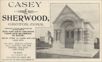
- Maine – Casey & Sherwood (advertisement in The Monumental News, Vol. 7, No. 12, December, 1895, pp. 755)
- Dedham, Hancock County, Maine - the Brown Quarry, from The Commercial Granites of New England, Bulletin 738, by T. Nelson Dale, U. S. Geological Survey, 1923.
These quarries were located "north of Mill Cove, Crotch Island." The operator was S. Clinton Sherwood, 14 Wall Street, New York. The granite in the lower and northern quarry was reportedly a light-gray color with a very slight buff tinge.
The lower quarry was opened in 1889. It covered a triangular area and in 1905 each side measured 75 feet long and 40 feet deep. Transport of the granite was by track 100 feet to the wharf. The quarry was worked only for special orders and produced stone for monuments, bases, etc.
Granite from the upper quarry, which was opened in 1890, was reportedly a pinkish-buff color with a coarse texture. In 1905 the upper quarry measured 200 by 100 feet with an average depth of about 15 feet. Transport of the granite was by cable and engine along a 900-foot track to the dock on the east side of the island. The granite from this quarry was used as "random" stone.

Casey & Sherwood, Groton, Conn.
Monuments, Statuary, Mausoleums and Building Work in
Red and Gray Granite from our quarries in Maine.
Rough Stock in Cargo and Car Load Lots.
Our Gray Granite is especially adapted for fine carving and statuary work.
We make a specialty of polished columns and pilasters in our Red Granite.
- Dedham, Hancock County, Maine - the Brown Granite Quarry (dark gray matrix with light grayish feldspars) Structures in which this stone was used include: the Maine Central Railroad Improvements in Bangor, Maine; and the Maine Central Railroad Bridge in Bangor, Maine. (For a more detailed description of granite and location of quarry, see Maine Quarries and Prospects published by the Maine Geological Survey, written by M. B. Austin and A. M. Huseey, II, John R. Rand, State Geologist, May 1, 1958, pp. 11.)
-
Deer Isle, Maine - New England Stone, LLC. The following
information is provided by Gordon J. Gianninoto owner of Deer Isle
Tile and Stone, Sedgwick, Maine. (Address: P.O. Box 211, Deer Isle, Maine
04627.) (The photographs displayed in this section were all taken
by Mr. Gianninoto, and the quotation below is used with his permission.)
Granite referred to as "'Stonington Granite' is actually known worldwide as Deer Isle® Granite. Deer Isle is a geographic place and Stonington is the town at the southern one half of Deer Isle. The town of Deer Isle, including Little Deer Isle is the northern half of Deer Isle. The Crotch Island quarry is one of dozens in Stonington, only 2 still operating, the other being the Cormier quarry. The northern half of the island of Deer Isle is glacial till and has no quarries. Little Deer Isle was the site of basalt mining to make the causeway to Deer Isle. Deer Isle is connected to Maine by a huge suspension bridge built in 1939.
" Deer Isle® Granite is the densest stone in the world at 193 pounds per cubic foot. It is part of all of lower Manhattan, the Washington Monument, the Brooklyn Bridge and the inside and outside of the largest and most expensive federal building in the US, the recently completed Ronald Reagan bldg. at 8 billion dollars.
"(To the right) are some photos I took today (June 2003) of Deer Isle® Granite at the Francis Cormier Quarry in Stonington. Fletcher granite no longer operates on Deer Isle in Stonington because they purchase all their stone from New England Stone off Crotch Island in Stonington Harbor, although they could and do whenever New England Stone, LLC charges them too much. Actually Fletcher has not cut a stone in Stonington since about 1995. New England Stone only cuts large blocks 5x5x10 feet and ships them to RI to be cut. Cormier does custom rough and flaked or burned work for small customers on the site. Cormier cannot saw or polish stone but sells to those who do.
"There is no such thing as 'Stonington granite.' It is all cut in Stonington, but is known ONLY as Deer Isle® Granite. The vein is quite large, at least 5 miles wide and 20 miles long, extending at least into Sedgwick on the mainland where I own the top of Caterpillar Mountain and have the exact same stone indistinguishable from the two active quarries in Stonington. (To the right is) a closeup of two quarry grout chips to show.the color.
"There is no difference between Crotch Island stone and Cormier stone. Both look exactly as I have shown you in photo 841 (to the right), [width of pieces shown = six inches]..."
"All three have large pink feldspar quartz crystals set in a dark grey background flecked with large specks of black about the size of whole peppercorns."
- Deer Isle, Maine - the Barred Island Reserve, maintained by the Nature Conservancy. On the web site, Maine's Hidden Treasure, you can read about the history of the island and what it is like today. The web site is presented by Thomas R. and Deborah A. Fletcher. They describe their walk on Barred Island Reserve on Deer Isle with their photographs and prose.
- Deer Isle, Hancock County, Maine - the Calvin Ames Granite Quarry (pinkish-buff color) Structures in which this stone was used include: Random and cellar stone. (For a more detailed description of granite and location of quarry, see Maine Quarries and Prospects published by the Maine Geological Survey, written by M. B. Austin and A. M. Huseey, II, John R. Rand, State Geologist, May 1, 1958, pp. 6.)
- Deer Isle, Maine - the Dear Isle Granite Co. (See: New England Stone, LLC.)
- Deer Isle, Maine - The Deer Isle Granite Co. - the Goss-Torrey Firm Records (1885-1950) In the Raymond H. Fogler Library, Special Collections (in Orono Maine), there is a collection of business records of the Deer Isle Granite Company and the John L. Goss Corporation in addition to "personal and family papers of the Goss and Torrey families." This material is listed in the "Granite Industry and Trade" section of the online "Subject Index to Manuscript Collections" list. (Also see: New England Stone, LLC - present-day company.)
- Deer Isle, Maine - "Granite industry, Deer Isle, Maine" (Image #6128 - photograph) This photograph is located in the statewide cultural database/online museum on The Maine Memory Network web site, a project of the Maine Historical Society. [Use the title in quotes above as the search words or use the image number in the search function of the web site to locate the photograph.]
- Deer Isle, Hancock County, Maine - the Hagan and Wilcox Granite Quarry (pinkish buff) Structures in which this stone was used include: Random stone in Philadelphia, Pennsylvania; the Brooklyn anchorage to the Manhattan Bridge in New York City; and the Bridge over the Potomac in Washington, D.C. (For a more detailed description of granite and location of quarry, see Maine Quarries and Prospects published by the Maine Geological Survey, written by M. B. Austin and A. M. Huseey, II, John R. Rand, State Geologist, May 1, 1958, pp. 15.)
- Deer Isle, Maine - New England Stone, LLC (previously the Dear Isle Granite Co.) (present-day company - photograph of items made of Deer Isle® Granite) Iitems are created from Deer Isle® Granite from Crotch Island, Maine, "the last island quarry in New England."
- Deer Isle, Maine - "Ryan-Parker Construction Co." (Image #6129 - photograph) This photograph is located in the statewide cultural database/online museum on The Maine Memory Network web site, a project of the Maine Historical Society. [Use the company name in quotes above as the search words or use the image number in the search function of the web site to locate the photograph.]
- Deer Isle, Maine - "Ryan-Parker Construction" (Image #6125 - photograph) This photograph is located in the statewide cultural database/online museum on The Maine Memory Network web site, a project of the Maine Historical Society. [Use the title in quotes above as the search words or use the image number in the search function of the web site to locate the photograph.]
-
Deer Isle, Maine - the Settlement Quarry (part of the Stonington
District), from The Commercial Granites of New England, Bulletin
738, by T. Nelson Dale, U. S. Geological Survey, 1923.
This quarry was "on Deer Isle, on Settlement Hill east of Webb Cove, 2 miles northeast of Stonington." The owner was the Rodgers Granite Corporation, 271 West 125th Street in New York. At the time of the report, the quarry was being leased by the George A. Fuller Co. of New York.. The granite in the quarry was reportedly a medium-gray with a slightly lavender tint, blotched with a cream white and of coarse texture.
The Settlement Quarry opened in 1900. Two quarries were measured in 1905: one was located near the top of the hill and measured 500 by 400 feet and had a depth from 10 to 18 feet; the other was on the west side and measured 600 by 60 feet and had a depth up to 14 feet. Transport of the granite was by locomotive and 2,500 feet of track. The cutting shed was 1,000 feet from the upper quarry and 600 feet from the cutting shed to the wharf.
The granite from the Settlement Quarry was used in massive construction. The granite was used in the following examples: the dry dock at Norfolk, Virginia; the base and approach for the addition to Bancroft Hall, United States Naval Academy, Annapolis, Maryland; the fish pier at Boston, Massachusetts; the sea wall at Providence, Rhode Island; the retaining wall at Riverside Drive (138th Street to the end); the Brooklyn and Manhattan approaches and piers to the Manhattan Bridge in New York. At the time of the report the quarry was supplying part of the granite for the new courthouse in New York.
- Deer Isle, Hancock County, Maine - the Settlement
Granite Quarry (medium gray, slightly lavender, blotched
with white) (For a more detailed description of the granite and location of quarry,
see Maine Quarries and Prospects published by the Maine Geological Survey, written by M. B. Austin and A. M. Huseey, II, John R. Rand, State Geologist, May 1, 1958, pp. 27.)
Structures in which this stone was used include: the Approach to the Williamsburg Bridge in New York City; the Piers in the Manhattan Bridge in New York City; the retaining wall on Riverside Drive in New York City; the Drydock in Norfolk, Virginia; and paving.
- Deer Isle, Maine - "Stonecutters, Deer Isle, Maine" (Image #6127 - photograph) This photograph is located in the statewide cultural database/online museum on The Maine Memory Network web site, a project of the Maine Historical Society. [Use the title in quotes above as the search words or use the image number in the search function of the web site to locate the photograph.]
This quarry was located "in the town of Dedham, 1 1/2 miles east of Holden station (East Holden post office) on the Maine Central Railroad, on the northeast side of a hill 840 feet above sea level and having a northwest-southwest axis." The operator was William J. Brown of East Holden, Maine.
Granite from the Brown Quarry was reportedly a dark-gray with lightish-grayish feldspars and a very coarse texture.
Minerals in descending order of abundance: Potash feldspar (orthoclase and microcline), smoky quartz, soda-lime feldspar (oligoclase), and black mica (biotite), together with accessory zircon, apatite, and secondary magnetite and chlorite.
Transport of the granite was by cart 1 1/2 miles to the cutting shed at Holden station. At the time of the report, the quarry had been idle since 1917. The granite from the quarry was used for bridge work.
Commercial use of material within this site is strictly prohibited. It is not to be captured, reworked, and placed inside another web site ©. All rights reserved. Peggy B. and George (Pat) Perazzo.