
Quarries & Quarry Links, Photographs and Articles
(The following list of Kansas quarries is not a complete list of all of the historical quarries in the state, only the ones I have been able to locate. If you know of more historical quarries in Kansas, please contact me. Peggy B. Perazzo)
Use the RootsWeb Town/County search form to find the county for specific Kansas towns.
- Kansas Stone Quarries – Active & Abandoned Quarries available on the Kansas Geological Survey “Kansas By County” Data Explorer.
- Active Quarries in Kansas (present-day), listed on Superyellowpages.com.
- Allen County, Kansas – Allen
County Limestone and Sandstone,
from the Kansas State Board of Agriculture, First Biennial Report,
Allen County, 1878, presented by Tom and Carolyn Ward on their KSGenWeb Project web
site. (The link from which the following information was obtained is no longer available, although you can view the page on the Internet Archive Wayback Machine.)
<http://skyways.lib.ks.us/genweb/archives/1878/allen.shtml>
“Building Stone, etc.: Blue and red limestone and red sandstone, of good quality, abound throughout the county. Every township in the county is well supplied mostly limestone.”
- Allen County, Kansas – Directory of Kansas Industrial Mineral Producers, presented by the Kansas Geological Survey.
(from the web site) “The 1998 Directory of Kansas Industrial Mineral Producers was compiled using records from the Kansas Geological Survey and the Kansas Conservation Commission as of June 1998. Individual entries include the company name, commodity produced, address and phone number, the type of operation, and the legal description for each operation.
“Included are known active leases for pits, quarries, and mines that produce limestone, dolomite, sandstone, gypsum, salt, sand and gravel, clay and shale, and volcanic ash. Also included are the locations of active sand and gravel dredges on the Kansas River as of October 1997, and companies that solution mine the underground salt in Reno, Rice, and Sedgwick counties.”
- Allen County, Kansas – Cement Limestone Quarry (photograph)
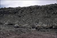 “Limestone quarry, used for cement”Photograph courtesy of Grace Muilenburg, KGS. The source of this
material is the Kansas Geological
Survey web site at <http://www.kgs.ku.edu/kgs.html>.
“Limestone quarry, used for cement”Photograph courtesy of Grace Muilenburg, KGS. The source of this
material is the Kansas Geological
Survey web site at <http://www.kgs.ku.edu/kgs.html>.
All Rights Reserved. This photograph is from the Kansas Geological Survey Photo Display System.
- Allen County, Kansas – Monarch Limestone Quarry (photographs)
 Photograph courtesy of Grace Muilenburg, KGS, July 1969. The source
of this material is the Kansas Geological
Survey web site at <http://www.kgs.ku.edu/kgs.html>.
Photograph courtesy of Grace Muilenburg, KGS, July 1969. The source
of this material is the Kansas Geological
Survey web site at <http://www.kgs.ku.edu/kgs.html>.
All Rights Reserved. The following photograph is from the Kansas Geological Survey Photo Display System.
- Allen County, Kansas – Stone Fence Quarry (photograph)
 Photograph courtesy of Robert Sawin, KGS. The source of this material
is the Kansas Geological
Survey web site at <http://www.kgs.ku.edu/kgs.html>.
Photograph courtesy of Robert Sawin, KGS. The source of this material
is the Kansas Geological
Survey web site at <http://www.kgs.ku.edu/kgs.html>.
All Rights Reserved. The following photograph is from the Kansas Geological Survey Photo Display System.
-
- Alma, Wabaunsee County, Kansas – Flint Hill Stone (Limestone
Quarry – present-day company) The Flint Hills Stone brochure is
used with permission. (You can view the Flint Hills Stone brochure in
pdf by clicking on the front page of the brochure below.)
Our Story (Flint Hill Stone)
“Flint Hills Stone is a family owned and operated business founded in 2008. All of the stone comes from our four generation family farm. We are located in the heart of the Flint Hills just east of Alma, the city of native stone….”
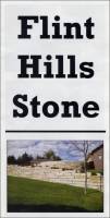
Brochure (pdf)

Alan, Alex & Ervin Gnadt
Ledge Limestone
- Anderson County, Kansas – Anderson
County Limestone and Sandstone, and Whetstone.
This material is from the Kansas State Board of Agriculture, First
Biennial Report, Anderson County, 1878, presented by Tom and Carolyn
Ward on their KSGenWeb Project web
site. (The link from which the following information was obtained is no longer available, although you can view the web site using the Internet Archive Wayback Machine.)
<http://skyways.lib.ks.us/genweb/anderson/library/1878/and1878.htm>“Building Stone, etc.: Good building stone abundant and of the best quality, consisting of lime and sandstone, easily obtained, varying from eight to twenty-eight inches thick, and smooth on surface of stratum. There is some shale, an excellent fire-proof stone, used for building furnaces for steam engines. A good quality of whetstone has been found....”
- Anderson County, Kansas – Directory of Kansas Industrial Mineral Producers, presented by the Kansas Geological Survey.
(from the web site) “The 1998 Directory of Kansas Industrial Mineral Producers was compiled using records from the Kansas Geological Survey and the Kansas Conservation Commission as of June 1998. Individual entries include the company name, commodity produced, address and phone number, the type of operation, and the legal description for each operation.
“Included are known active leases for pits, quarries, and mines that produce limestone, dolomite, sandstone, gypsum, salt, sand and gravel, clay and shale, and volcanic ash. Also included are the locations of active sand and gravel dredges on the Kansas River as of October 1997, and companies that solution mine the underground salt in Reno, Rice, and Sedgwick counties.”
- Anthony, Kansas - the Doran Monument Works (from Design
Hints For Memorial Craftsmen, May 1930, Vol. 6, No. 11, pp. 27)
The Doran Monument Works was listed as one of the customers of the Mount Brothers of Memphis Missouri, who sold their Air Take-off Device used in carving cemetery stones.
- Arkansas City, Kansas – H.
J. Born Stone Company, Inc. (Building Limestone Quarry) (present-day
company), RR 3 Box 312, Arkansas City, KS 67005-9396; (316) 442-5750.
(The following information is from Kansas
Geological Survey, “Industrial Minerals - Chase County; Both
Active and Abandoned Quarries.)
Location of active surface quarry of H. J. Born Stone Company Inc.:
T19S, R6E, Sec. 12, E2, Long: -96.71332, Lat: 38.41326
- Arkansas City, Kansas - H. J. Born Stone Company,
Inc. - Also see the following entry below for photographs of
H. J. Born Stone Company Inc. quarries:
Cowley County, Kansas – H. J. Born Company Inc. Photographs
- Arkansas City, Kansas –
Stone Quarry North of Arkansas City from the Arkansas City
Republican, Arkansas City, Kansas, presented by Bill Bottorff. (The
following quotation is used with the permission of Dr. William (Bill)
Bottorff.)
Arkansas City Republican, March 12, 1887:
"The Courier says that Chas. J. Lantry of Strong City was there yesterday and expressed the opinion that Winfield was to be the great city of the southwest. That=s (sic) peculiar. Mr. Lantry is a member of the firm of Lantry & Son, Arkansas City, and has now working for him some 30 men in the stone quarries north of the city. Strange that Mr. Lantry invests his money in Arkansas City, when he believes Winfield is going to be such a great town."
[Note: this time Lantry...not Langtry.]
"Beautiful building stone is obtained at the quarry nearby, owned by S. T. Covey, formerly of Arkansas City."
- Atchison County, Kansas – Atchison
County Sandstone and Limestone. From
the Kansas State Board of Agriculture, First Biennial Report,
Atchison County, 1878, presented by Tom and Carolyn Ward on their KSGenWeb Project web site. (The link from which the following information was obtained is no longer available, although you can view the web site using the Internet Archive Wayback Machine.)
<http://skyways.lib.ks.us/genweb/archives/1878/atchison.shtml>“Building Stone, etc.: Sandstone, white, blue and grey limestone, abound throughout the county....”
- Atchison County, Kansas – Directory of Kansas Industrial Mineral Producers, presented by the Kansas Geological Survey.
(from the web site) “The 1998 Directory of Kansas Industrial Mineral Producers was compiled using records from the Kansas Geological Survey and the Kansas Conservation Commission as of June 1998. Individual entries include the company name, commodity produced, address and phone number, the type of operation, and the legal description for each operation.
“Included are known active leases for pits, quarries, and mines that produce limestone, dolomite, sandstone, gypsum, salt, sand and gravel, clay and shale, and volcanic ash. Also included are the locations of active sand and gravel dredges on the Kansas River as of October 1997, and companies that solution mine the underground salt in Reno, Rice, and Sedgwick counties.”
- Barber County, Kansas – Directory of Kansas Industrial Mineral Producers, presented by the Kansas Geological Survey.
(from the web site) “The 1998 Directory of Kansas Industrial Mineral Producers was compiled using records from the Kansas Geological Survey and the Kansas Conservation Commission as of June 1998. Individual entries include the company name, commodity produced, address and phone number, the type of operation, and the legal description for each operation.
“Included are known active leases for pits, quarries, and mines that produce limestone, dolomite, sandstone, gypsum, salt, sand and gravel, clay and shale, and volcanic ash. Also included are the locations of active sand and gravel dredges on the Kansas River as of October 1997, and companies that solution mine the underground salt in Reno, Rice, and Sedgwick counties.”
- Barbour County, Kansas – Barbour
County Sandstone and Limestone.
From the Kansas State Board of Agriculture, First Biennial Report,
Barbour County, 1878, presented by Tom and Carolyn Ward on their KSGenWeb Project web
site. (The link from which the following information was obtained is no longer available, although you can view the web site using the Internet Archive Wayback Machine.)
<http://skyways.lib.ks.us/genweb/archives/1878/barbour.shtml>“Building Stone, etc. - Building stone is reported plenty throughout the northwestern portion of the county; said to be of good quality - generally sandstone, but limestone is reported near Sun City....”
- Barton County, Kansas – Directory of Kansas Industrial Mineral Producers, presented by the Kansas Geological Survey.
(from the web site) “The 1998 Directory of Kansas Industrial Mineral Producers was compiled using records from the Kansas Geological Survey and the Kansas Conservation Commission as of June 1998. Individual entries include the company name, commodity produced, address and phone number, the type of operation, and the legal description for each operation.
“Included are known active leases for pits, quarries, and mines that produce limestone, dolomite, sandstone, gypsum, salt, sand and gravel, clay and shale, and volcanic ash. Also included are the locations of active sand and gravel dredges on the Kansas River as of October 1997, and companies that solution mine the underground salt in Reno, Rice, and Sedgwick counties.”
- Barton County, Kansas – Fort Zarah, Kansas, presented by Larry and Carolyn
Mix on their Santa Fe Trail
Research Site. (Read this article using the link above to find
the exact location where the fort once stood, a picture of the fort,
and a more detailed story of the events below.)
In February 1865 the Second Colorado Cavalry worked on building the octagonal stone blockhouse. According to this web site, Fort Zarah was abandoned for the first time in April, 1866. The fort was ordered rebuilt and reopened, and "...was rebuilt of 'sandstone with a tin roof' approximately one-half mile north/northwest of the previous location, and was completed in 1867." For the last time Fort Zarah "was finally dismantled and abandoned in December of 1869."
A Kansas Historical Marker located on the grounds of the park called Fort Zarah Park reads: ".The fort was built of sandstone quarried in nearby bluffs. Fort Zarah was successfully defended against an attack by 100 Kiowas on Oct. 2, 1868. It was abandoned in 1869."
The sandstone used to build the fort was "quarried from the bluffs about three miles to the north." The stone was "mostly of a deep purplish brown, varying to a light brown." Mortar was used to set the stones, and the "outer walls were about 16 inches thick, the inner walls one foot."
- Beattie, Marshall County, Kansas – Stone Quarries
(history). Stone quarrying early in Beattie's history included
these quarries: The FitzGerald Quarry and the Hawk Quarry. Both building
and bridge stone were taken from the FitzGerald Quarry, and building
stone was taken from the Hawk Quarry. Railroad tracks were built to
theses quarries so that great quantities of stone could be shipped
out. Beattie stone was used in several of the buildings at Kansas
State College in Manhattan. Stone quarried from the FitzGerald Quarry
provided stone for the foundations for buildings in the town and country,
and a lot of it went to St. Joseph. The writer of this article wrote
that the material for the web site, which was much more extensive
than what is presented above, was obtained from
An Affair With the Past – From the Otoes to the Astronauts,
by Byron E. and Eulalia T. Guise. (The link from which this information
was obtained is no longer available.
<http://www.marshallco.net/beattie/hisstory2.html> - Beattie, Marshall County, Kansas – Stone Quarries.
The stone quarries were one of the reasons the town of Beattie was
located at that place. Those quarries provided stone for Kansas and Nebraska
for building purposes. In 1949 they were partially abandoned. One of the
quarries was started in 1875 by Mr. FitzGerald on his own farm. (Written
by J. D. Stosz on July 15, 1949.) (The web site from which this information
was obtained is no longer available.)
<http://www.marshallco.net/beattie/map.html> - Beloit (south of), Mitchell County, Kansas –
Fenceposts South of Beloit (photograph)
 Photograph courtesy of Grace Muilenburg, KGS, June, 1966. The source
of this material is the Kansas Geological
Survey web site at <http://www.kgs.ku.edu/kgs.html>.
Photograph courtesy of Grace Muilenburg, KGS, June, 1966. The source
of this material is the Kansas Geological
Survey web site at <http://www.kgs.ku.edu/kgs.html>.
All Rights Reserved. The following photograph is from the Kansas Geological Survey Photo Display System.
- Bourbon County – Bourbon
County Lime and Sandstone. From the Kansas
State Board of Agriculture First Biennial Report 1878, presented
by Tom and Carolyn Ward on their KSGenWeb
Project web site.
(The link from which the following information was obtained is no longer available, although you can view the web site using the Internet Archive Wayback Machine.)
<http://skyways.lib.ks.us/genweb/archives/1878/bourbon.shtml>“Building Stone, etc.- Lime and sandstone of good quality is found in all localities.”
- Bourbon County, Kansas – Directory of Kansas Industrial Mineral Producers, presented by the Kansas Geological Survey.
(from the web site) “The 1998 Directory of Kansas Industrial Mineral Producers was compiled using records from the Kansas Geological Survey and the Kansas Conservation Commission as of June 1998. Individual entries include the company name, commodity produced, address and phone number, the type of operation, and the legal description for each operation.
“Included are known active leases for pits, quarries, and mines that produce limestone, dolomite, sandstone, gypsum, salt, sand and gravel, clay and shale, and volcanic ash. Also included are the locations of active sand and gravel dredges on the Kansas River as of October 1997, and companies that solution mine the underground salt in Reno, Rice, and Sedgwick counties.”
- Bourbon County, Kansas – Bandera Sandstone Quarry (photographs) Photographs courtesy of Grace Muilenburg. The source of this material is the Kansas Geological Survey web site at <http://www.kgs.ku.edu/kgs.html>. All Rights Reserved. The following photographs are from the Kansas Geological Survey Photo Display System.
- Bourbon County, Kansas – Bandera Sandstone Quarry (detailed photograph of the distribution of the Bandera Shale) The quarry is located near the town of Redfield. The source of this material is the Kansas Geological Survey web site at <http://www.kgs.ku.edu/kgs.html>. All Rights Reserved
- Bourbon County, Kansas – Fort Scott Stone (From William G. Cutler's History of the State of Kansas, first published in 1883 by A. T. Andreas, Chicago, IL, Kansas Collection Books) "An extensive quarry of fine flagging stone is found about five miles west of Fort Scott. This stone exists in layers from two to five inches in thickness, is known as the Fort Scott stone, and is shipped in all directions and as far eastward as St. Louis."
- Bourbon County, Kansas – Ft. Scott Cement Quarry (photograph)
 Photograph courtesy of Grace Muilenburg. The source of this material
is the Kansas Geological
Survey web site at <http://www.kgs.ku.edu/kgs.html>.
Photograph courtesy of Grace Muilenburg. The source of this material
is the Kansas Geological
Survey web site at <http://www.kgs.ku.edu/kgs.html>.
All Rights Reserved. The following photograph is from the Kansas Geological Survey Photo Display System.
- Bourbon County, Kansas – the Abandoned Marmaton River Sandstone Quarry, presented by the Kansas Geological Survey, Current Research in Earth Sciences, Bulletin 241, part 2.
- Brown County, Kansas – Brown
County Limestone. From the Kansas
State Board of Agriculture, First Biennial Report, Brown County,
1878, presented by Tom and Carolyn Ward on their KSGenWeb Project web site. (The link from which the following information was obtained is no longer available, although you can view the web site using the Internet Archive Wayback Machine.)
<http://skyways.lib.ks.us/genweb/archives/1878/brown.shtml>“Building Stone, etc. - Abundance of sand and limestone along the banks, north and south, of Pony creek, in Hamlin township, found in inexhaustible quantities near the banks of Walnut, Spring and Mulberry creeks, also Delaware creek, in Walnut township; good quantities near banks of Bunn's creek; good sand and limestone on south fork of Wolf river, also in other portions of Robinson township; limestone found in different portions of Mission township; both sand and limestone are found near all the banks of the streams in Powhattan township.”
- Brown County, Kansas – Directory of Kansas Industrial Mineral Producers, presented by the Kansas Geological Survey.
(from the web site) “The 1998 Directory of Kansas Industrial Mineral Producers was compiled using records from the Kansas Geological Survey and the Kansas Conservation Commission as of June 1998. Individual entries include the company name, commodity produced, address and phone number, the type of operation, and the legal description for each operation.
“Included are known active leases for pits, quarries, and mines that produce limestone, dolomite, sandstone, gypsum, salt, sand and gravel, clay and shale, and volcanic ash. Also included are the locations of active sand and gravel dredges on the Kansas River as of October 1997, and companies that solution mine the underground salt in Reno, Rice, and Sedgwick counties.”
- Buffalo (near), Woodson County, Kansas – Micro-Lite Lamproite Quarry, near Buffalo (photograph) Lamproite, a rare (in Kansas) igneous rock is quarried at this location. This material is presented on the GeoKansas Field Trips web site, Kansas Geological Survey.
- Burdett, Kansas - the “Lime Kiln Restoration Project,” by the Wet/Dry Routes Chapter of the Santa Fe Trail Burdett, Kansas "1996," on the Santa Fe Trail Research web site, presented by Larry and Carolyn Mix.
- Butler County, Kansas – Directory of Kansas Industrial Mineral Producers, presented by the Kansas Geological Survey.
(from the web site) “The 1998 Directory of Kansas Industrial Mineral Producers was compiled using records from the Kansas Geological Survey and the Kansas Conservation Commission as of June 1998. Individual entries include the company name, commodity produced, address and phone number, the type of operation, and the legal description for each
“Included are known active leases for pits, quarries, and mines that produce limestone, dolomite, sandstone, gypsum, salt, sand and gravel, clay and shale, and volcanic ash. Also included are the locations of active sand and gravel dredges on the Kansas River as of October 1997, and companies that solution mine the underground salt in Reno, Rice, and Sedgwick counties.”
- Cedar Point, Chase County, Kansas - Harshman
Construction Company (present-day company), Rt. 1, Cedar
Point, Kansas 66843; (316) 274-4377 - Limestone Quarries (The
following information is from Kansas
Geological Survey, “Industrial Minerals - Chase County; Both
Active and Abandoned Quarries.) (The link from which the following information was obtained is no longer available.)
<http://abyss.kgs.ku.edu/pls/abyss/minerals.pqd3.mainCounty?cnty=17>Location of active limestone quarries of Harshman Construction Company:
T20S, R7E, Sec. 9, NW, Long: -96.66724, Lat: 38.33002
T20S, R7E, Sec. 4, E2, Long: -96.65797, Lat: 38.34085
- Cedron, Lincoln County – Possible Marble Quarry on the land of A. Shriner. From the Lincoln
County Beacon, Cedron area news section, Thursday, April 7, 1881. (This information was obtained
from Gleanings from 1881, Lincoln County Kansas, Newspapers. Harvested
by Bill and Diana Sowers, Tracee Hamilton and others.) (The link from which the following information was obtained is no longer available, although you can view the web site using the Internet Archive Wayback Machine.)
<http://skyways.lib.ks.us/genweb/lincoln/glean1881.htm>“A. SHRINER says he has a marble quarry upon his place north of town about a mile. We hope this will prove true.”
- Chanute (near), Neosho County, Kansas – Ash Grove Quarry near Chanute (photograph)
 Photograph courtesy of Grace Muilenburg. The source of this material
is the Kansas Geological
Survey web site at <http://www.kgs.ku.edu/kgs.html>.
Photograph courtesy of Grace Muilenburg. The source of this material
is the Kansas Geological
Survey web site at <http://www.kgs.ku.edu/kgs.html>.
All Rights Reserved. The following photograph is from the Kansas Geological Survey Photo Display System.


Commercial use of material within this site is strictly prohibited. It is not to be captured, reworked, and placed inside another web site ©. All rights reserved. Peggy B. and George (Pat) Perazzo.