
Excerpts From
Construction Materials in Smith
County, Kansas
Geological Survey Circular 25
By Frank E. Byrne, Max S. Houston, and Melville R. Mudge
Department of the Interior for Development, Geological
Survey
Washington, D. C., April, 1949
Purpose of the Investigation
The State Highway Commission of Kansas and the United States Geological Survey are cooperating in the compilation of a State-wide inventory of construction materials. A field party composed of personnel from the two cooperating agencies was sent into Smith County, Kans., in the summer of 1947, to investigate sources of engineering construction materials. This report of the Smith County investigation is a part of the general inventory and a contribution to the geologic mapping and investigation of mineral resources being made in connection with studies of the Missouri River Basin.1
-
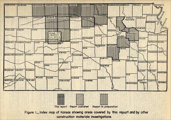
Figure 1. Index map of Kansas showing areas covered by this report and by other construction materials investigations.

Area covered by the investigation
Smith County is in the first tier of Kansas counties south of the Nebraska border and in the sixth tier east of Colorado. (See fig. 1.) It comprises 25 townships and covers an area of about 9900 square miles. The county is bounded by parallels 39° 34' and 40° 00' north latitude and meridians 98° 30' and 99° 04' west longitude. It is bordered on the east by Jewell County, on the west by Philips County, on the south by Osborne County, all in Kansas, and on the north by Franklin and Webster Counties, Nebr.
Geography of the Area
Smith County is in the border region of the Great Plains physiographic province. It has been dissected into moderate relief by streams cutting headward from the lower level of the Central Lowlands province to the east. The principal streams have cut their valleys about 100 feet below the rolling upland surface. The lowest altitude is about 1,500 feet along Oak Creek in the Southeast corner of the county. The highest altitudes are on the divides in the northwest corner of the county, some of which are more than 2,100 feet above sea level..
Two railways serve Smith County. One of the main lines of the Chicago, Rock Island, and Pacific Railroad enters near the midpoint of the eastern boundary and crosses the county. Smith Center, the county seat and largest city, Lebanon, Kensington, and Athol are located along this railroad. A branch line of the Missouri Pacific Railroad parallels the North Fork of the Solomon River and serves Gaylor, Cedar, Harlan, and Claudell.
Two Federal highways, both of the all-weather type of construction, principally black-top, cross the county. U. S. 36, a major east-west transcontinental route, extends through the center of the county. U. S. 281 enters the county from the south, runs north to Smith Center, turns east along U. S. 36, which it follows to a point 1.5 miles south of Lebanon, then turns north again and leaves the county at its northeast corner. Kansas Highway 9 parallels the Missouri Pacific Railroad and from Gaylord southeast coincides with U. S. 281. Kansas Highway 181 enters the county 2 miles west of the southeast corner and extends north to its intersection near Lebanon with U. S. 181, which it follows to the northern border of the county. Kansas Highway 8 branches from U. S. 36 a mile west of Athol and extends north to the Nebraska border. The county and township roads generally follow section lines. The more important ones are metalled, and most of the others are maintained by grading.
-
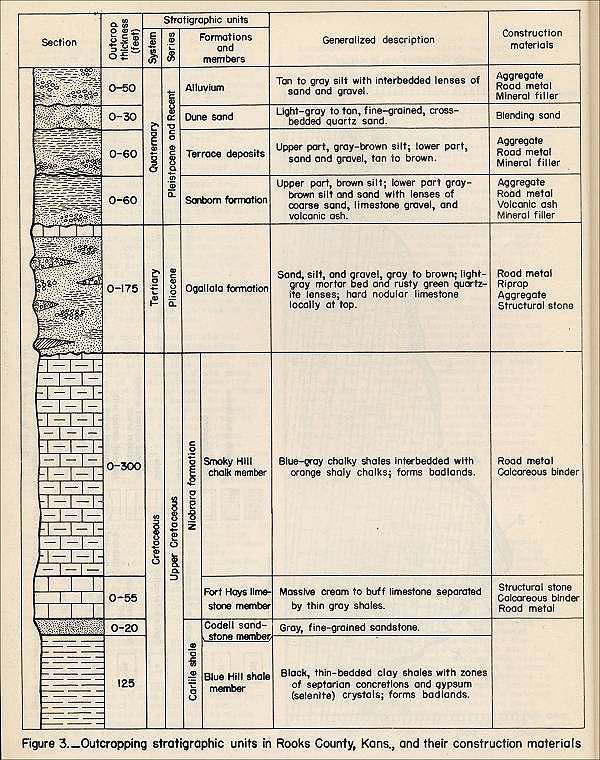
Figure 3. Outcropping stratigraphic units in Smith County, Kansas, and their construction materials.

Inventory of Construction Materials
(Note: Only the section on "Structural Stone" will be
included here.)
Structural Stone
Engineering and Geologic Characteristics: Structural stone, as defined in this report, is any hard, dense rock material that can be quarried and cut to desired size and shape. Materials fulfilling these requirements occur in the Fort Hays limestone member of the Niobrara formation and in the Ogallala formation.
Stratigraphic Sources and Performance Characteristics
(1) Fort Hays Limestone Member of the Niobrara Formation: Blocks of Fort Hays limestone are used extensively throughout north-central Kansas as structural stone for the construction of dwellings and farm buildings. The limestone is quite soft but hardens after being cut, and structures built of it seem to stand up well in the relatively dry climate of north-central Kansas. Field observations indicate that the Fort Hays limestone should not be used in any place where it will be subjected to water saturation unless it has been protected by a cement cover coat. This stone deteriorates rapidly in the presence of water, either by slaking or freeze-and-thaw. The test characteristics are given for one sample of limestone collected from this stratigraphic unit.
(2) Smoky Hill chalk member of Niobrara Formation: The test characteristics of the silicified material locally present at the top of the Smoky Hill chalk member.indicate that this material is acceptable as structural stone. In the quarrying operation, however, the stone appears to shatter excessively because of its brittleness. This characteristic, in addition to the difficulty of shaping the stone because of its hardness, would probably make the material of doubtful value for use as structural stone.
(3) Ogallala Formation: Quartzite ledges in the Ogallala formation have been quarried extensively in north-central Kansas for structural stone. Numerous city and county buildings and several bridges constructed of this material were observed in the field. The opinion has been expressed that the opal in the quartzite is reactive with standard cement to the detriment of the structure in which the quartzite is used as a structural stone or as a constituent of concrete aggregate. No field evidence of this type of failure was observed, however. The stone is sufficiently hard to cause difficulty in cutting it to required size and shape.
Occasional use of hard mortar-bed ledges in the Ogallala formation as structural stone for farm buildings, such as barns, was observed in north-central Kansas. Its test characteristics.indicate that it might be acceptable for this use, but field observations show that the ledges are not uniformly hard and that structures built of mortar bed may deteriorate appreciably within a relatively short time if the stone used is below standard.
The hard compact limestone layer locally present at the top of the Ogallala formation has been used occasionally as a structural stone. The test characteristics of the material indicate that it is acceptable for this use. A church in New Almelo, in the southwest corner of Norton County, was built of this material, and although the stone is not especially pleasing in appearance, it has stood up very well over a long period of time.
1 Construction Materials in Cloud County, Kansas, 1951, page 1, footnote 1: Missouri River Basin, conservation control, and use of water resources: 78th Cong., 2d sess., S. doc. 191, 1944.
Commercial use of material within this site is strictly prohibited. It is not to be captured, reworked, and placed inside another web site ©. All rights reserved. Peggy B. and George (Pat) Perazzo.