
Excerpts From
Construction Materials in Graham
County, Kansas
Geological Survey Circular 51
By
Frank E. Byrne, Vincent B. Coombs,
and Claude W. Matthews
Prepared in cooperation with the State Highway Commission
of Kansas,
R. C. Keeling, State Highway Engineer, and S. E. Horner, Chief Geologist.
Prepared as part of a program of the Department of the Interior
for Developmentof the Missouri River Basin.
Washington, D. C., January 1951.
-
Figure 1. Index map of Kansas showing areas covered by this report and by other construction materials investigations.

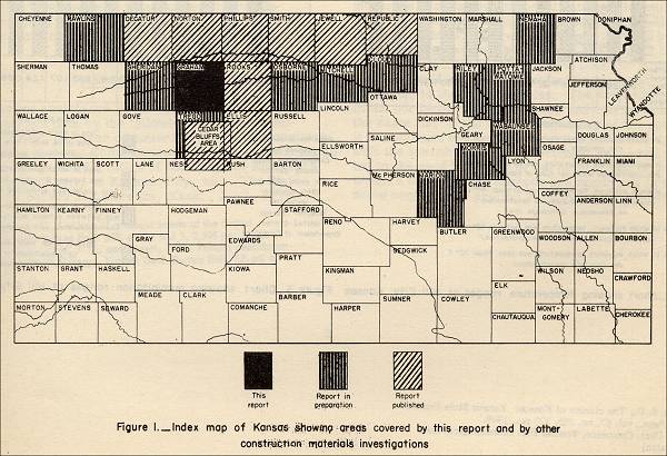
Figure 1. Index map of Kansas showing areas covered by this report and by other construction materials investigations.
Purpose of the Investigation
The State Highway Commission of Kansas and the United States Geological Survey are cooperating in a State-wide inventory of construction materials. A field party composed of personnel from the two cooperating agencies investigated sources of engineering construction materials in Graham County, Kans., in the summery of 1947. This report of the Graham County Investigation is a part of the general inventory and a contribution to the geologic-mapping and mineral-resource investigations being made in connection with the studies of the Missouri River Basin.1
The primary objective of the investigation was that of accumulating all field and laboratory data pertaining to the geologic materials in Graham County that would be of use in the construction of dams, irrigation canals, highways, airports, and other engineering structures. Additional geologic data are included in this report, but only to the extent of providing information useful in the development of the prospects reported in the inventory, or for the location of other materials required for future engineering needs.
Geography of the Area
Graham County is in the second tier of Kansas counties south of the Nebraska border in the fourth tier east of Colorado. (See fig. 1.) It comprises 25 townships and covers an area of about 900 square miles. the county is bounded by parallels 39° 08' and 39° 34' north latitude and meridians 99° 36' 08" and 100° 10' west longitude. It is bounded on the north by Norton County, on the east by Rooks County, on the south by Trego County, and on the west by Sheridan County.
Topography: Graham County is in the Plains Border section of the Great Plains physiographic province.2 The surface drainage is to the east, and for that reason the eastern part of the county is somewhat more dissected than the western part. The interstream areas are usually flat or gently rounded; they are sharp-crested only along the valleys of the major streams. The valleys of the principal streams and their larger tributaries are cut 175 feet below the general upland level. The upland surface is highest along the western border of the county, in places rising slightly more than 2,500 feet above sea level. The lowest point in the county, at an altitude of about 1,980 feet, is in the valley of the South Fork Solomon River at the eastern boundary of the county.
Transportation routes: Graham County is served by one railroad, a branch line of the Union Pacific; two transcontinental highways ( U. S. 24 and U. S. 283); and one highway (18). The Federal highways are of the black-top type of construction, and the State highway is a metaled, all-weather road. County and township roads, for the most part, follow section lines. Some of them are metaled with materials available locally, whereas others are maintained as earth roads. The locations of the roads and the railroad are shown on plate 1. (Plate 1 is not included on this web site.)
-
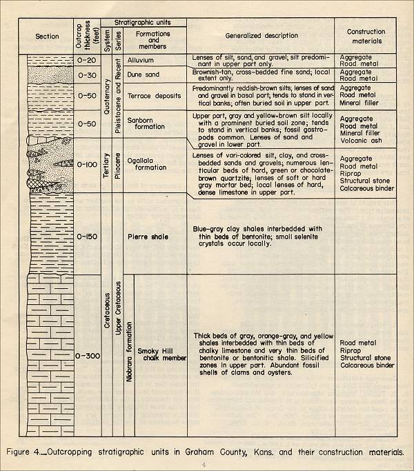
Figure 4. Outcropping Stratigraphic units in Graham County, Kans. and their construction materials.
Stratigraphic Sources and Performance
Characteristics
(Note: Only the section on "Structural Stone" will be included here.)
Structural Stone
Engineering and Geologic Characteristics:
Structural stone, as defined in this report, is any hard, dense rock materials that can be quarried and produced to the desired size and shape. Materials fulfilling these requirements occur in the Smoky Hill chalk member of the Niobrara formation and in the Ogallala formation.
Stratigraphic Sources and Performance Characteristics
(1) Smoky Hill Chalk Member of the Niobrara: Test characteristics and field observations of the more massive beds of chalky limestone in the Smoky Hill member indicate that the limestone is acceptable for use as structural stone. No such use was observed in Graham County, but farm buildings observed elsewhere in Kansas indicate that the stone is satisfactory if it is not used in a place where it will be subjected to water saturation. The chalky limestone deteriorates rapidly in the presence of water, either by slaking or freeze-and-thaw.
The silicified chalks locally present in the Smoky Hill chalk member are potentially useful as structural stone. The material is usually hard, however, and producing it to the desired size and shape may be an excessive cost factor. In addition, its brittleness may cause it to shatter too much during the quarrying operation. The chemical properties of the silicified chalk are probably similar to those of quartzite.
(2) Ogallala Formation: Quartzites of the Ogallala formation were used in the construction of the city hall and the buildings in the city park of Hill City and in Antelope Lake Park. Field observations of these structures in 1947 and 1948 disclosed no evidences of surface deterioration or excessive reaction with the mortar, but it is possible, according to Mansfield Merriman, Bureau of Reclamation, United States Department of the Interior, that failure through mortar reaction may occur in structures or parts of structures immersed in water. Because of the hardness of the quartzite, the process of producing it to the desired size and shape may be costly.
Hard mortar-bed ledges in the Ogallala have been used as structural stone in other counties in western Kansas, as in the grade-school building at Traer, Norton County. Field observation indicates that the harder mortar-bed ledges perform satisfactorily when so used. It is recommended that a constant check be made of the quality of this stone because of rapid lateral variations in mortar beds.
Stone quarried from the hard local limestone bed near the top of the Ogallala formation was used in the construction of the church in New Almelo, Norton County, Kans. the stone is not too pleasing in appearance but has stood up very well for nearly 50 years.
1 Construction Materials in Graham County, Kansas, 1951, page 1, footnote 1: Missouri River Basin, conservation control, and use of water resources: 78th Cong., 2d sess., S. doc. 191, 1944.
2 Ibid., page 1, footnote 2: Frye, J. C., "The High Plains Surface in Kansas," Kansas Acad. Sci. Trans., vol. 49, no. 1, pp. 81-82, June 1946.
Commercial use of material within this site is strictly prohibited. It is not to be captured, reworked, and placed inside another web site ©. All rights reserved. Peggy B. and George (Pat) Perazzo.