
List of Quarries in Iowa
& Quarry Links,
Photographs and Articles
- Nora Springs, Floyd County, Iowa – Shell Rock River, Nora Springs,
Floyd County, Iowa.
Plate XLVII (From Iowa Geological Survey, Vol. XVII, Fifteenth Annual Report of the Iowa State Geologist, 1906.) 
- North Farley, Dubuque County, Iowa – Arquitt Bros. Quarry, somewhat
obscured by an excessive amount of talus. North Farley, Dubuque
County, Iowa.
Figure 18 (From Iowa Geological Survey, Vol. XVII, Fifteenth Annual Report of the Iowa State Geologist, 1906.) 
- Olin, Jones County, Iowa - Limestone Quarries from Reminiscences
of Rome - 1840-1841, by R. J. Cleveland (Jones County, Iowa,
County GenWeb Project web site) (The link from which the following information was obtained is no longer available.)
<http://rootsweb.com/~iajones/history/rome.htm>There were three magnesian limestone quarries mentioned by Mr. Cleveland that were located within a mile of Olin reportedly with the same quality and texture of the quarries at Anamosa.
- Olin, Iowa – Olin Quarry, 13048 32nd Street, Olin, Iowa, (319) 484-2387, an Aggregate Quarry of Wendling Quarries, Inc. (present-day company) (This link is no longer available, although you can view the map on the Internet Archive Wayback Machine.)
<http://www.wendlingquarries.com/locations/index.html> - Osage Township, Iowa - The Lewis Lime Quarry, in the southeast quarter
of section 27, Osage Township, one and one-half miles southwest of Osage.
Fig. 27 (From Iowa Geological Survey, Vol. XVII, Fifteenth Annual Report of the Iowa State Geologist, 1906.) 
- Ottumwa, Iowa – the Hardsocg Wonder Drill Co. (The following
information is from an advertisement in Pit and Quarry: Sand - Gravel
- Stone, magazine, December 1921, pp. 4.)
Hardsocg Wonder Drill Co.
Ottumwa, Iowa
Agencies in all principal cities.Hardsocg No. 3
It is a Wonder - A Trial Will Prove It
A valve operated drill with wonderful drilling speed; strong rotation; easy to hold, blowing device that will clean wet holes or holes to any desired depth.Made of the highest grade material obtainable. Repairs practically eliminated. Write today for catalog.
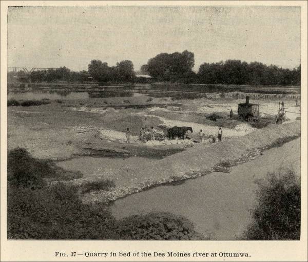
- Ottumwa, Iowa - Quarry in bed of the Des Moines River at Ottumwa.
Fig. 37 (From Iowa Geological Survey, Vol. XVII, Fifteenth Annual Report of the Iowa State Geologist, 1906.) 
- Preston, Iowa – Preston Quarry, 46796 Highway 64, Preston, Iowa, (563) 689-6921, an Aggregate Quarry of Wendling Quarries, Inc. (present-day company) (This link is no longer available, although you can view the map on the Internet Archive Wayback Machine.)
<http://www.wendlingquarries.com/locations/index.html> - Robins, Iowa – Robins Quarry, 605 N. Mentzer Road, Robins, Iowa 52328, (319) 393-7925, an Aggregate Quarry of Wendling Quarries, Inc. (present-day company) (This link is no longer available, although you can view the map on the Internet Archive Wayback Machine.)
<http://www.wendlingquarries.com/locations/index.html> - Sigourney, Keokuk County, Iowa - Miller Quarry, about two miles north
of Sigourney, Keokuk County, Iowa, showing Pella beds.
Plate LVII (From Iowa Geological Survey, Vol. XVII, Fifteenth Annual Report of the Iowa State Geologist, 1906.) 
- Springville, Iowa – Bowser Quarry, 933 Dubuque Road, Springville, Iowa 52336, (319) 854-7300, an Aggregate Quarry of Wendling Quarries, Inc. (present-day company) (This link is no longer available, although you can view the map on the Internet Archive Wayback Machine.)
<http://www.wendlingquarries.com/locations/index.html> - Tipton, Iowa – Stonemill Quarry, 1090 Stonemill Road, Tipton, Iowa, (563) 886-2666, an Aggregate Quarry of Wendling Quarries, Inc. (present-day company) (This link is no longer available, although you can view the map on the Internet Archive Wayback Machine.)
<http://www.wendlingquarries.com/locations/index.html> - Tracy, Marion County, Iowa - Near view of quarry face, Tracy, Marion
County, Iowa, showing Pella beds.
Plate LVII (From Iowa Geological Survey, Vol. XVII, Fifteenth Annual Report of the Iowa State Geologist, 1906.) 
- Stennett, Iowa - Typical exposure of the Missouri stage of the Coal
Measures. Fate Quarry, Stennett.
Plate LX (From Iowa Geological Survey, Vol. XVII, Fifteenth Annual Report of the Iowa State Geologist, 1906.) 
- Stone City, Jones County, Iowa - Champion Quarry showing track and
derrick arrangements and channeler. Stone City, Jones County, Iowa.
Plate XLI (From Iowa Geological Survey, Vol. XVII, Fifteenth Annual Report of the Iowa State Geologist, 1906.) 
- Stone City, Jones County, Iowa - John Ronen Quarry, showing arrangement
of tracks, derricks and crusher plant. Stone City, Jones County,
Iowa.
Plate XLII (From Iowa Geological Survey, Vol. XVII, Fifteenth Annual Report of the Iowa State Geologist, 1906.) 
- Taylor Township, Iowa - Exposure in an abandoned quarry, section
15, Taylor Township. The Acervularia davidsoni coral
reef appears at the top. The view shows the character of the layers
between this coral reef and the zone of Acerularia profunda.
Fig. 21 (From Iowa Geological Survey, Vol. XVII, Fifteenth Annual Report of the Iowa State Geologist, 1906.) 
- Union Township, Fayette County, Iowa - Wilkes Williams Quarry showing
the rough, heavy bedded facies of the Niagara, section 22, Union Township,
Fayette County, Iowa.
Fig. 19 (From Iowa Geological Survey, Vol. XVII, Fifteenth Annual Report of the Iowa State Geologist, 1906.) 
- Vinton, Iowa – Vinton Quarry, 2530 58th Street, Vinton, Iowa 52349, (319) 472-2023, an Aggregate Quarry of Wendling Quarries, Inc. (present-day company) (This link is no longer available, although you can view the map on the Internet Archive Wayback Machine.)
<http://www.wendlingquarries.com/locations/index.html> - Waverly, Bremer County, Iowa - Quarry and crusher plant of Cedar
River Stone Company, near Waverly, Bremer County, Iowa. The
quarry stone is brought to a platform at the foot of an inclined plane
leading to crusher. The irregularly bedded stage of the Devenian
is well shown in the quarry. Thin-bedded limestone is seen at top.
Plate XLV (From Iowa Geological Survey, Vol. XVII, Fifteenth Annual Report of the Iowa State Geologist, 1906.) 
- Washington County, Iowa - Irregular beds of limestone in the Saint
Louis, Verdi Quarry, Washington County.
Fig. 38 (From Iowa Geological Survey, Vol. XVII, Fifteenth Annual Report of the Iowa State Geologist, 1906.) 
- Winterset, Madison County, Iowa - Quarry near top of hill southwest
of Winterset, showing limestone above the black shale which appears well
up in the ravines south of town.
Fig. 43 (From Iowa Geological Survey, Vol. XVII, Fifteenth Annual Report of the Iowa State Geologist, 1906.) 
- Winterset, Madison County, Iowa - Winterset Quarry located about
one-half mile southeast of the court house, Winterset, Madison County,
Iowa.
Fig. 42 (From Iowa Geological Survey, Vol. XVII, Fifteenth Annual Report of the Iowa State Geologist, 1906.) 
- Wyoming, Iowa – Wyoming Quarry, 17532 Highway 136, Wyoming, Iowa, (563) 488-3800, an Aggregate Quarry of Wendling Quarries, Inc. (present-day company) (This link is no longer available, although you can view the map on the Internet Archive Wayback Machine.)
<http://www.wendlingquarries.com/locations/index.html>




Commercial use of material within this site is strictly prohibited. It is not to be captured, reworked, and placed inside another web site ©. All rights reserved. Peggy B. and George (Pat) Perazzo.