
List of Quarries in Georgia & Quarry Links,
Photographs and Articles
- Pine Mountain, Lithonia, Georgia – Pine Mountain
(Granite-Gneiss),
from A Preliminary Report on a Part of the Granites and Gneisses
of Georgia, Bulletin No. 9-A, by Thomas L. Watson, Ph.D.,
Assistant Geologist, Geological Survey of Georgia, 1902, pp. 152.
Plate XIII. A view of Pine Mountain, Lithonia, Georgia, an unreduced residual of granite-gneiss, from a point of view, a quarter of a mile away. 
- Pine Mountain, Lithonia, Georgia – Granite-Gneiss
Quarries at Pine Mountain (Granite-Gneiss),
from A Preliminary Report on a Part of the Granites and Gneisses
of Georgia, Bulletin No. 9-A, by Thomas L. Watson,
Ph.D., Assistant Geologist, Geological Survey of Georgia, 1902, pp.
160.
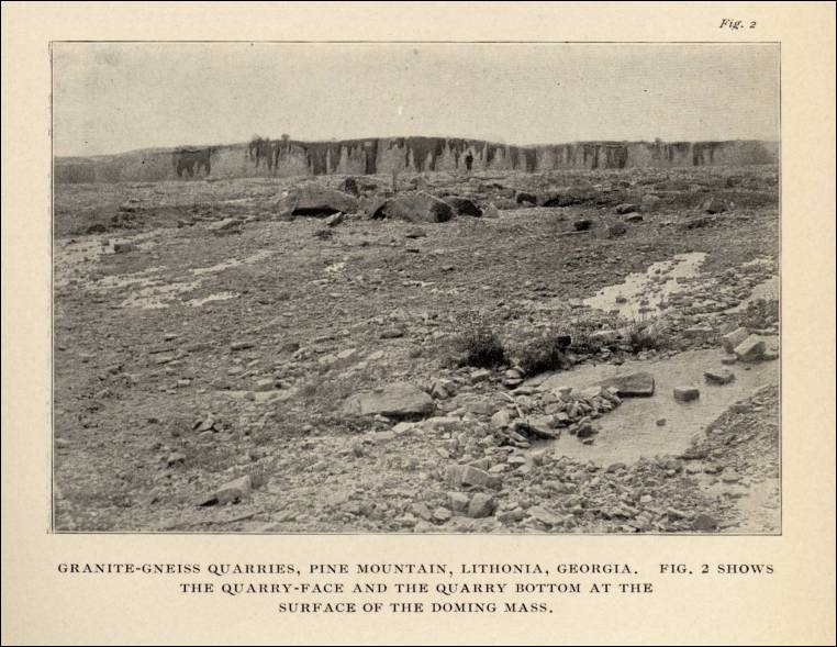
Plate XIV. Fig. 1. Granite-Gneiss quarries, Pine Mountain, Lithonia, Georgia. 
Plate XIV. Fig. 2. Shows the quarry-face and the quarry bottom at the surface of the doming mass. 
- Pine Mountain, Lithonia, Georgia – Granite-Gneiss
Quarries, Pine Mountain (Granite-Gneiss) (from A Preliminary
Report on the Mineral Resources of Georgia, Bulletin No. 23,
by S. W. McCallie, State Geologist, Geological Survey of Georgia,
Atlanta: 1910, pp. 88)
Plate VIII. Fig. 1. Granite-Gneiss Quarries, Pine Mountain, Lithonia, Georgia. (Note: This is the same photo as used in A Preliminary Report on a Part of the Granites and Gneisses of Georgia, 1902, above.) 
Plate VIII. Fig. 2. Shows the quarry-face and the quarry bottom at the surface of the doming mass. (Note: This is the same photo as used in A Preliminary Report on a Part of the Granites and Gneisses of Georgia, 1902, above.) 
- Polk County, Georgia – Piedmont Portland Cement Company
Plant (Limestone), from A Report on the Limestones and
Cement Materials of North Georgia, Bulletin No. 27, by T. Poole
Maynard, Ph.D., Assistant State Geologist, Geological Survey of Georgia,
1912, frontispiece.
Plant of the Piedmont Portland Cement Company, Polk County, Georgia. 
- Portland, Polk County, Georgia – the Piedmont Portland
Cement Company Quarry (Limestone), from A Report on the
Limestones and Cement Materials of North Georgia, Bulletin No.
27, by T. Poole Maynard, Ph.D., Assistant State Geologist, Geological
Survey of Georgia, 1912, pp. 146.
Pl. XIII. A. Chickamauga limestone, quarry of the Piedmont Portland Cement Company, Portland, Polk County, Georgia. 
-
Redan (north or), DeKalb County, Georgia – the Smith Quarry (Granite) (Excerpt from Geology of The Stone Mountain-Lithonia District, Georgia, by Leo Anthony Herrmann, Georgia State Division of Conservation, Department of Mines, Mining and Geology, Atlanta: 1954, pp. 95. Used with permission. You can read the entire entry for this quarry in the document/chapter on “The Stone Industry (of Georgia).)”
“Smith Quarry – A small quarry on the Smith property one-half mile north of Redan is owned by the Venable Estate of Stone Mountain. The rock is coarse-grained, non-foliated Stone Mountain granite composed of quartz, oligoclase, microcline, muscovite, biotite and small pink garnets. Many small biotite-rich inclusions are found in the rock.
- Redan (north of), DeKalb County, Georgia – the Wells Quarry (Granite) (Excerpt from Geology of The Stone Mountain-Lithonia District, Georgia, by Leo Anthony Herrmann, Georgia State Division of Conservation, Department of Mines, Mining and Geology, Atlanta: 1954, pp. 95-96. Used with permission. You can read the entire entry for this quarry in the document/chapter on “The Stone Industry (of Georgia).)”


“Only a small amount of stone was quarried from this location. The small size of the exposure and the poor quality of the stone make it undesirable for future quarrying.”
- Rising Dawn, Dade County, Georgia – the Southern Iron and Steel Company – Lower Quarry (Limestone), from A Report on the Limestones and Cement Materials of North Georgia, Bulletin No. 27, by T. Poole Maynard, Ph.D., Assistant State Geologist, Geological Survey of Georgia, 1912, pp. 208.
“Wells Quarry – A quarry owned by Steven Wells, located a mile and a quarter north of Redan, is situated in fine-grained evenly textured Stone Mountain granite. It is a light gray rock composed of microcline, quartz, oligoclase, muscovite, biotite, and minor amounts of epidote, zircon, and garnet (Table 5, No. L-58).
“A faint foliation in the rock is barely discernible. Small quartz veins cut the granite in various directions in the quarry. The rock is very good quality, hard, and free from blemishes. It was originally quarried to build the DeKalb County Court House in Decatur.”
- Rock Chapel Hill, Georgia – Arch Produced by the Bursting
of a Thin Sheet of Granite-Gneiss, Rock Chapel Hill, Near Lithonia,
Georgia (Granite-Gneiss)
Width of arch, 14 feet; height, 9 inches. Plate VII-A (photograph from The Granites of Maine, Bulletin 313, 1907.) 
- Rockdale-DeKalb-Gwinnett Area, Georgia – Map
of the DeKalb-Rockdale-Gwinnett Granite and Granite-Gneiss Area,
from A Preliminary Report on a Part of the Granites and Gneisses
of Georgia, Bulletin No. 9-A, by Thomas L. Watson,
Ph.D., Assistant Geologist, Geological Survey of Georgia, 1902, pp.
112.
Map of the DeKalb-Rockdale granite and granite-gneiss area of Georgia. 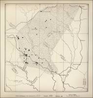
| Plate XVII. A. Bangor limestone, lower quarry of Southern Iron and Steel Company, 1 mile northeast of Rising Fawn, Dade County, Georgia. |  |


Commercial use of material within this site is strictly prohibited. It is not to be captured, reworked, and placed inside another web site ©. All rights reserved. Peggy B. and George (Pat) Perazzo.