
List of Quarries in Colorado & Quarry Links, Photographs and Articles
(Please note: Gypsum quarries will not be included in this list.)
- Marble Quarry Gulch - Quarry Days in the Ute Trail Area, by Dick Dixon, Colorado Central Magazine, February 1998.
- Masonville, Colorado - Colorado
Flagstone (present-day company) P.O. Box 63,
Masonville, Colorado 80541. Physical address: 4301
North County Road 27, Loveland, Co 80538. Phone: 970-203-1072,
Fax: 970-203-0130. (You
will find photographs of the flagstone quarry throughout the
web site.)
The following quotation is from the Colorado Flagstone web site:
“Since 1986, Colorado Flagstone, Inc. has been supplying stone masons, builders, architects and landscape professionals with the highest quality Sandstone.”
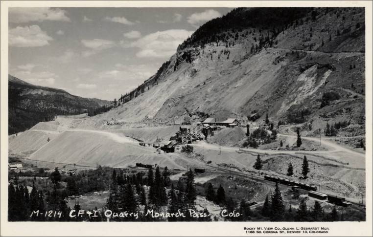
- Monarch Pass, Colorado - C. F. & U. Quarry, Monarch Pass., Colo. (postcard photograph, No. M-1214; “Rocky Mt. View Co., Glenn L. Gebhardt Mgr., 1166 So. Corona St., Denver 10, Colorado”; early 1900s; unmailed)
C. F. & U. Quarry, Monarch Pass, Colo., Rocky Mt. View Co., Glenn L. Gebhart Mgr., 1166 So. Corona St., Denver 10, Colorado (postcard photograph, M-1214) 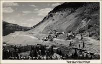
- Mount
Sanitas History – Lyon
Sandstone Quarries – The following information was presented by the City
of Boulder Open Space & Mountain Parks Department. (The link from which the following history was obtained is no longer available.)
<http://www.bouldercolorado.gov/index.php?option=com_content&task=view&id=2777&Itemid=1082#sanitas>The sandstone quarries in this area during the 1920s were owned by the University of Colorado, and the stone was used to build many of the campus buildings, including Helms and Sewell Hall. Due to danger and high operating costs, the quarries were abandoned. In 1969 the City of Boulder purchased the quarries and later in 1974 the surrounding land was also purchased.
- The Pikes Peak Area - Stone Quarries in the Pikes Peak Area - the Rio Grande Railroad. "Taming a Wilderness," Part V - Rapid Growth of Rio Grande Territory Justifies General Palmer's Faith; Development of the Pikes Peak Region No. 8," from the Denver and Rio Grande Western Magazine, June 1926, presented by Ghost Depot - Rio Grande Railroad (photographs and history)
- Portland, Fremont County, Colorado – Colorado Portland Cement Company Cement & Wall Plaster Plant & Shale Quarry (The photographs and information below are from the U. S. Geological Survey Photographic Library.)
“Portland Cement and Wall Plaster plants of Colorado Portland Cement Company. Shale quarry shows on upper left horizon. Fremont County. Portland, Colorado. No date. USGS Photographic Library ID. Burchard, E. F. 0734bef00734” 
“Quarry P.C. Company of Colorado, Portland. Fremont County, Colorado. 1903. USGS Photographic Library ID. Eckel, E.C. 25 eec00025” 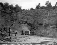
- Pueblo, Colorado – the Pueblo Limestone Supply
Company (From Stone: An Illustrated Magazine,
Vol. XII, No. 1, December, 1895, “Notes From Quarry and
Shop” section, Stone Publishing Co., New York, pp. 84
and 90.)
“Financial - The Pueblo (Col.) Limestone Supply Company; incorporators. D. Blackwell, E. C. Betts and R. A. Simpson. Capital stock, $10,000; principal office at Pueblo.”
“Another incorporation certificate filed was that of the Pueblo (Col.) Limestone Supply ‘Company, organized for the purpose of buying and selling stone, leasing and operating stone quarries for the purpose of fluxing and building. The capital stock is $10,000 divided into 1,000 shares of $10 each. John D. Blackwell, E. C. Betts and R. A. Simpson appear as incorporators and directors.”
- Pueblo (near), Colorado - Turkey Creek Sandstone Quarry
(today a part of Fort Carson)
According to the Pueblo County Historical Society’s web site, there was a quarry near Pueblo that quarried Turkey Creek Sandstone, which was used in the County Courthouse and other Pueblo buildings. According to the GlobalSecurity.org web site, Fort Carson was created as one of many new military installations in 1942 during World War II.
- Red
Rock Canyon, Colorado - Sandstone Quarries (Lyons
and Dakota Sandstone) (The link from which this information
was obtained is no longer available.)
<http://www.saveredrockcanyon.com/index.htm>The Red Rock Canyon area includes three distinct canyons, separated by ridges of Lyons and Dakota sandstone.
- Red Rock Canyon - Red Rock Canyon Photo Tour - Sandstone Quarries, presented by HelloColoradoSprings.com (photographs)
- Salida, Colorado – the Salida Granite Co. Works (postcard photograph; early 1900s; unmailed)
Salida Granite Company Works (postcard photograph; early 1900s) 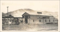
- Salida, Chaffee County, Colorado - Salida Granite Co. Federal Quarry - From Turret to Salt Lake City Mormon Battalion Monument in Salt Lake City, Utah, 1927. Article by Dick Dixon, Colorado Central Magazine, January 1998.
- Salida Granite Company Federal Quarry (Chaffee County) - John Earl Herschberger, the Man who Carved the Lions. Article by Dick Dixon, Colorado Central Magazine, January 1998.
- Salida Granite Company Federal Quarry (Chaffee County) - Hard Rock from Turret (Granite) Article by Dick Dixon, Colorado Central Magazine, December 1997.
- Salida Granite Co. Federal Quarry (Chaffee County) - Quarry Days in the Ute Trail Area, Article by Dick Dixon. This quarry produced the Salida rose pink granite about the 1920s that was used to build the Mormon Battalion Monument.
-
Sherwood Railroad Station, Eagle County, Colorado – Sandstone Quarry located high above the railroad tracks (If you know anything about this quarry or would like to send in photographs of it, I will add it to the entry. Peggy B. Perazzo)
One of our visitors wrote about the remains of this quarry which he described as follows:
“…there is a large red rock outcrop and at its top are the remains of a steel tripod. Locals say that the tripod was the top station of a cable where a horse and drum system was used to lower quarried rock to railroad cars below. They say that the rock was shipped to Denver for use on buildings….”
- Below is some information I’ve compiled about the Sherwood Station, a station on the Denver and Rio Grande Railroad:
- The following quotation is from the Gazetteer of Colorado, U. S. Geological Survey Bulletin No. 291, Series F., Geography, 51, by Henry Gannett, 1906, U.S. Government Printing Office, 1906, pp. 154. (This book is available on Google Books.)
“Sherwood; station in Eagle County on Denver and Rio Grande Railroad; altitude, 6,890 feet.”
- The following quotations are from: A Descriptive History of Eagle County, Colorado: relating to mining, agriculture, stock and scenery, by William McCabe, 1899, pp. 15. (This book is available on Google Books.)
Other Industries
“Besides mining, agriculture and stock, Eagle county has other industries which lead to manufacturers and increase the revenue of the Industrious….The county also has two quarries, whose products are used in the construction of business blocks in the larger cities of the state. One of these, situated at Sherwood, on the D. & R. G., has shipped stone as far east as Chicago. It is a red sandstone, noted for its good qualities. The other quarry is at Peach Blow, a station in the Midland Railroad above the town of Basalt. Its rock is a grand quality of sandstone. These quarries have never been worked to their fullest point of production, but they have a state reputation for the excellence of their material….”
- The following is from Motor Age, Vol. 24, August 21, 1913, pp. 10.
The Gateway of the West
“Sixty miles from Hot Sulphur we reached Wolcott where a road branches off toward the Red Cliff country southward to Buena Vista. Our road continued westward with excellent road conditions all the way. Shortly after passing Sherwood, a little station on the D. and R. G., the valley narrows with the cliffs almost meeting to form a gigantic gateway to the valley. Bright red soil and brilliant carmine rocks marked the gate and through it the westering sun appeared like a flame. Almost immediately beyond these rocky portals the valley spreads out into a pleasing farming country to Eagle.
“This is on the main line of the D. and R. G. railway, which we found our route followed all the way to Grand Junction. Like most of the points on the route through Colorado, Eagle has magnificent mountain views in almost every direction, each group of mountains varying in its own kind of beauty, some with snow-covered peaks the year round, others covered with green timber and still others of the red sandstone that take on varying hues as the position of the sun changes throughout the day…The natural resources are the timber and the deposits of gypsum, a quarry of the latter being within the town limits. A short distance to the west of Eagle we found an extinct volcano, with acre upon acre of lava beds.”
- The following is from History of Colorado, Volume 1, by Wilbur Fiske Stone, published by S. J. Clarke, 1918, pp. 306. (This book is available on Google Books.)
“Eagle County – Gold, silver, copper, lead, zinc, carnotite, gypsum, manganese, sandstone, granite and other building stone, little developed manganosiderite (carbonate of manganese and iron), turquoise.”
- The following quotation is from the Gazetteer of Colorado, U. S. Geological Survey Bulletin No. 291, Series F., Geography, 51, by Henry Gannett, 1906, U.S. Government Printing Office, 1906, pp. 154. (This book is available on Google Books.)
- Below is some information I’ve compiled about the Sherwood Station, a station on the Denver and Rio Grande Railroad:
- Silver Cliff, Custer County, Colorado – Security / Geyser Mine/Quarry (Rhyolite) (The following photographs and information are from the U. S. Geological Survey Photographic Library.)
“Quarry in rhyolite ‘Security’ (‘Geyser’) mine. Silver Cliff, Rosita Hills District, Custer County, Colorado. 1888. USGS Photographic Library ID. Cross, C.W. 114 ccw00114” 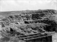
“Quarry in rhyolite ‘Security’ (‘Geyser’). Silver Cliff, Rosita Hills district, Custer County, Colorado. 1888. USGS Photographic Library ID. Cross, C.W. 115 ccw00115” 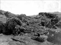
- Stout,
Northern Colorado - Flagstone Quarries. “In it’s
heyday, Stout was a boomtown.- Now, part of it's under
Horsetooth Reservoir.” This article was originally published
in the Greeley
Tribune. (The link from which this information was
obtained is no longer available.) <http://abouthorsetooth.com/html/stout.asp>
- Horsetooth Reservoir – Quarry Cove (photograph)
- Trinidad, Las Animas County, Colorado - Stone Quarries
in the Trinidad Region (history) The following
material is from an article entitled, "Library serving community
since 1904," written by Tamara Louden-Sundahl, Staff Writer, Trinidad
Plus,
May 9, 2000. Stone used in the construction of the Trinidad
Carnegie Public Library originated from local sandstone
quarries. Although there were several small quarries in the
region, three main quarries provided the stone (mainly sandstone)
during the Victorian period for the area. (The
web address from which the above information was obtained
is no longer available.)
<http://www.trinidadco.com/stories2000/news/05/09/sidebar_carnegie.html>
- The Trinidad Carnegie Library, presented by the Carnegie
Public Library (photographs and history) The following information
is taken from “Trinidad’s
Library Built in 1904, by Rona Stansbury, February
24, 1997.” (The link from which the following information was obtained is no longer available.)
<http://www.trinidadco.com/walkingtour/carnegie.asp>
A donation of $15,000 from Andrew Carnegie provided the funds to build the library in Trinidad. John G. Haskell, from Topeka, Kansas, was selected as the architect for the Neoclassical library building in 1903. The contract was signed by a local firm, Crouch & Smith, in October 1903 to construct the library. The sandstone used in the construction was quarried locally at the James Radford Quarry, and William McDonald was the chosen stone mason for the project.
- The Trinidad Carnegie Library, presented by the Carnegie
Public Library (photographs and history) The following information
is taken from “Trinidad’s
Library Built in 1904, by Rona Stansbury, February
24, 1997.” (The link from which the following information was obtained is no longer available.)
- Turret (east of), Chaffee County, Colorado - Stonehenge Quarry East of Turret, Colorado - Quarry Days in the Ute Trail Area, Article by Dick Dixon, Colorado Central Magazine, February 1998.
- Turret (east of), Chaffee County, Colorado - Cameron Mountain Granite Quarry East of Turret - Quarry Days in the Ute Trail Area, Article by Dick Dixon. This quarry produced a dark blue granite.
- Unaweep Canyon, Colorado – Taylor Granite Quarry in western Colorado – One of our visitors let me know about this quarry. He describes it as follows:
“Unaweep Canyon is located south of Whitewater Co. and north of Gateway, Co. on the road to the Uncompagre Plateau. The quarry operated from the top of the canyon and lowered to the bottom. There is some rigging left at the site.”
- Unaweep/Tabegauche Scenic and Historic Byway, Mile by Mile, Part 4 (includes photograph), on gorp.com. The information on the Taylor Granite Quarry below is a part of “Unaweep/Tabegauche Scenic and Historic Byway Overview.”
139.8 - Divide Road Turnoff
“An excellent overlook of Unaweep Canyon can be reached by following the Divide Road for three miles south to the site of the old Taylor Granite Quarry, which operated briefly in 1928. North of the quarry, on the opposite side of the canyon, is a large man-made opening. Here in the early 1940s the Army Corps of Engineers conducted experiments on the effect of explosives on granite.”
Below are some web sites that provide either information or photographs of the quarry area in Unaweep Canyon:
- Taylor Quarry in the Unaweep Canyon, Photograph, by BeardieLover/Marji on Flickr.
- Unaweep Canyon & Quarry Walls Photograph, by Steve Marr, presented on the summitpost.org web site.
- Unaweep Canyon & Quarry Wall (photographs), presented on mountainproject.com.
- Unaweep Canyon, on Wikipedia.


Commercial use of material within this site is strictly prohibited. It is not to be captured, reworked, and placed inside another web site ©. All rights reserved. Peggy B. and George (Pat) Perazzo.