
Placer County – List of Stone Quarries, Etc. *
(* Please note this list does not include sand or gravel quarries.)
- Applegate (near), Placer County, California – the Spreckels Sugar Company Limestone Deposit (Excerpt from Report XV of the State Mineralogist, Mines and Mineral Resources of Portions of California, Chapters of State Mineralogist’s Report Biennial Period 1915-1916, Part III. The Counties of El Dorado, Placer, Sacramento, Yuba, California State Mining Bureau, 1919, pp. 271-459. Used with permission, California Department of Conservation, California Geological Survey.)
“The Spreckels Sugar Company is reported to have purchased the Mason property near Applegate in Secs. 8 and 9, of T. 13 N., R. 9 E., M. D. M. The company is reported to have secured the property for a limestone deposit which is suitable for sugar refining. The rock will be shipped to company’s refineries on San Francisco bay.”
- Applegate Station (near), Placer County, California – Spreckels Limestone Deposit (Limestone) (Excerpts from “Limestone in California,” by Clarence A. Logan, California Journal of Mines and Geology, Vol. 43, No. 3, July 1947, California Division of Mines, San Francisco, California, pp. 175-357. Used with permission, California Department of Conservation, California Geological Survey.)
“Spreckels limestone deposit is assessed to C. F. and Nora C. Brunckhorst, Applegate. This was patented as Excelsior Mining and Milling Claim, 25.66 acres in secs. 8 and 9, T. 13 N., R. 9 E., M.D., 1 mile from Applegate Station and alongside the Southern Pacific Railroad.
“Like several other small but accessible limestone deposits in this county, this one was worked in early days and lime was produced in a kiln on the property. Spreckels Sugar Company purchased the claim and surrounding land. They drilled the deposit and worked it for a year ending in October 1916. Since then it has been idle.
“The limestone is below the surface level. Drilling indicates an irregular deposit, the thickness of good limestone varying in different holes from 17 to 106 feet. An estimate based on drilling indicates 424,000 tons of limestone to a depth of 100 feet. It is fine-grained, bluish-gray and reported to be of good quality though no analysis is available.”
- Applegate (near), El Dorado County, California – Spreckels (Limestone Deposit) (Excerpt from “The Cool-Cave Valley Limestone Deposits, El Dorado and Placer Counties, California,” by William B. Clark, Junior Mining Geologist, California Division of Mines, California Journal of Mines and Geology, Vol. 50, Nos. 3 and 4, July-October 1954, pp. 439-466. (Used with permission, California Department of Conservation, California Geological Survey.)
“The Spreckels deposit half a mile southeast of Applegate was worked by the Spreckels Sugar Company for one year ending in October 1916. It is fine-grained bluish-gray limestone. The deposit is 650 feet long and varies from 100 to 200 feet in width (Logan, 1927, p. 282).”
The following information is taken from “Table 1. Limestone deposits in the general area of the Cool-Cave Valley limestone,” (circa 1954) on pages 462 and 463:
(No. on map, Plate 3) 15; (Deposit) Spreckels, Applegate; (Owner) C. F. Brunkhorst, Applegate; (Location) Secs. 8, 9; T. 13 N., R. 9 E., M.D.; (References) Tucker 19:391: Logan 27:282; 47:266.
- Applegate Station (near), Placer County, California – Spreckels Limestone Deposit (Limestone) (Excerpts from “Limestone in California,” by Clarence A. Logan, California Journal of Mines and Geology, Vol. 43, No. 3, July 1947, California Division of Mines, San Francisco, California, pp. 175-357. Used with permission, California Department of Conservation, California Geological Survey.)
- Applegate Station (south of), Placer County, California – Pacific Portland Cement Company/Lime Rock Limestone Deposit (Limestone Deposit) (Excerpts from “Limestone in California,” by Clarence A. Logan, California Journal of Mines and Geology, Vol. 43, No. 3, July 1947, California Division of Mines, San Francisco, California, pp. 175-357. Used with permission, California Department of Conservation, California Geological Survey.)
“Another deposit under the…ownership (of the Pacific Portland Cement Company) is 4.2 miles by road south of Applegate station on the Southern Pacific Railroad. It is in W ½ sec. 21 T. 13 N., R. 9 E., and has been partly eroded away by the North Fork of American River, with the remaining parts separated by the North Fork debris dam, so that the part east of the dam is not accessible from Applegate, but may be reached from the Auburn-Forest Hill road. By that road it is about 10 miles from railroad.
“The old private road to the western part of deposit, which connects with the county road to Applegate, is in fair condition. It rises 825 feet in 2 ½ miles. On this side, the limestone shows a width of 300 feet at the old lime kiln (1000 feet elevation) and has backs of about 400 feet above the level of the dam. Only a small amount of the stone has been quarried, although it appears to be of good quality. There is a large tonnage on the east side of the dam, and this is said to have been extensively prospected and sampled.”
- Auburn, Placer County, California – the Auburn Deposit/Wendell T. Robie (Limestone Deposit) (From “The Cool-Cave Valley Limestone Deposits, El Dorado and Placer Counties, California,” by William B. Clark, Junior Mining Geologist, California Division of Mines, California Journal of Mines and Geology, Vol. 50, Nos. 3 and 4, July-October 1954, pp. 439-466. (Used with permission, California Department of Conservation, California Geological Survey.)
“A deposit known as the Auburn deposit just east of Auburn was quarried many years ago. It is composed of somewhat shattered white marble (Aubury, 1906, p. 101).
- Auburn, Placer County, California – Wendell T. Robie (Limestone Deposit) (From “The Cool-Cave Valley Limestone Deposits, El Dorado and Placer Counties, California,” by William B. Clark, Junior Mining Geologist, California Division of Mines, California Journal of Mines and Geology, Vol. 50, Nos. 3 and 4, July-October 1954, pp. 439-466. (Used with permission, California Department of Conservation, California Geological Survey.)
The following information is taken from “Table 1. Limestone deposits in the general area of the Cool-Cave Valley limestone,” (circa 1954)on pages 462 and 463:
(No. on map, Plate 3) 1; (Deposit) Auburn; (Owner) Wendell T. Robie, Auburn; (Location) Sec. 14, T. 12 N., R 8 E., M.D.; (References) Aubury 06:101; Logan 27:281.
- Auburn, Placer County, California – Wendell T. Robie (Limestone Deposit) (From “The Cool-Cave Valley Limestone Deposits, El Dorado and Placer Counties, California,” by William B. Clark, Junior Mining Geologist, California Division of Mines, California Journal of Mines and Geology, Vol. 50, Nos. 3 and 4, July-October 1954, pp. 439-466. (Used with permission, California Department of Conservation, California Geological Survey.)
- Auburn (near), Placer County, California – the Auburn Quarry
(Marble) (From The Structural and Industrial Materials of California,
Bulletin No. 38, California, State Mining Bureau, San Francisco,
California, 1906.)
"Auburn Quarry, in Sec. 14, T. 12 N., R. 8 E.; W. S. Davis, Auburn, owner. A somewhat shattered white marble, although masses of considerable size have been quarried. It is exposed for a height of about 25 feet, over a distance of about 100 feet."
- Auburn (near), Placer County, California – Burton (Petterson) Limestone Deposit (Limestone) (Excerpts from “Limestone in California,” by Clarence A. Logan, California Journal of Mines and Geology, Vol. 43, No. 3, July 1947, California Division of Mines, San Francisco, California, pp. 175-357. Used with permission, California Department of Conservation, California Geological Survey.)
“Burton (Petterson) Deposit. This deposit is assessed to A. J. and Mattie F. Burton, R.F.D. Box 208, Auburn . It is in S ½ sec. 3, T. 12 N., R. 8 E., M.D., just outside the city limits of Auburn and 1 ½ miles northwest by paved road from Railroad Street station on the west-bound line of the Southern Pacific Railroad.
“This is a small deposit of high-calcium limestone which was worked in the early mining days when lime was made in a pot kiln nearby. The limestone was excavated as deeply as natural drainage would permit over an area 150 by 250 feet and the old quarry site is now traversed by a small stream forming a marshy area which would have to be drained before any work could be done. Part of the deposit is also probably concealed by soil so its full size could only be determined by stripping and drilling. It is a light gray, fine-to-medium-grained crystalline stone of firm texture.
“The following analysis was made by Abbott A. Hanks, Inc., of a sample taken in November 1943.”
Analysis of limestone from Burton deposit, by Abbot. A. Hanks.
Insoluble, 1.06 percent
Ferric and Aluminic oxides, 0.97 percent
Calcium carbonate, 96.3 percent
Magnesium carbonate, 1.51 percent
Total, 99.84 percent. - Auburn (near), Placer County, California – the Mountain Quarry Railroad Bridge built
to serve the Limestone Quarry 1912 (postcard photograph; early
1900s; unmailed)
The Mountain Quarry Railroad Bridge built to serve the limestone quarry, was the first concrete bridge built for a railroad in the United States. The bridge crosses the American River near Auburn. 
- Auburn (northeast of), Placer County, California – Verde
Antique Marble Exposure (Serpentine Marble) (From The Structural and Industrial Materials
of California, Bulletin No. 38, California, State Mining Bureau,
San Francisco, California, 1906.)
"Verde Antique. In Sec. 1, T. 13 N., R. 9 E.; Mr. Dunning, Oakland, owner; about 16 miles northeast from Auburn. The serpentine marble, or verde antique, is exposed for 100 feet or more in height and between 400 and 500 feet wide, on the northerly slope of the hill that looks down upon the American River. The deposit is not extensive east and west, and appears to be a series of ledges. Some prospecting has been done, and small pieces of ornamental design have been polished by Joseph Boleres of Forest Hill. It is a beautiful stone, green and blue in color, and if found compact in sufficiently large masses would prove a profitable property.
- Auburn State Recreation Area, Placer County, California – Limestone Quarry (Limestone) (The previous version of this site noted a limestone quarry had been located within the recreation area. The present version does not mention it at all.)
- Browns Bar (near), El Dorado
County, California – Browns
Bar (Limestone) (From “Mines
of El Dorado County,” by Doug Noble, El
Dorado County Library web site.)
“Browns Bar claim was a deposit of bluish-gray limestone near Browns Bar by the Middle Fork of the American River. It was apparently never worked.”
- Brown’s Bar, Placer County, California – Pacific Portland Cement Company (Limestone Deposit) (From “The Cool-Cave Valley Limestone Deposits, El Dorado and Placer Counties, California,” by William B. Clark, Junior Mining Geologist, California Division of Mines, California Journal of Mines and Geology, Vol. 50, Nos. 3 and 4, July-October 1954, pp. 439-466. (Used with permission, California Department of Conservation, California Geological Survey.)
The following information is taken from “Table 1. Limestone deposits in the general area of the Cool-Cave Valley limestone,” (circa 1954) on pages 462 and 463:
(No. on map, Plate 3) 2; (Deposit) Brown’s Bar; (Owner) Pacific Portland Cement Company, 417 Montgomery Street, San Francisco; (Location) Sec. 4., T. 12 N., R. 9 E., M.D.
- Burton Creek State Park, Placer County, California – Slate Quarry (The previous version of this site noted a slate quarry located within the state park. The present version does not mention it at all.)
- Cape Horn, Placer County, California – Talc Deposit owned
by D. Russell (From The Structural and Industrial Materials of
California, Bulletin No. 38, California, State Mining Bureau, San
Francisco, California, 1906.)
"D. Russell, Colfax. In Sec. 35, T. 15 N., R. 9 E., under Cape Horn, is a deposit of talc that has never been thoroughly prospected nor any effort made toward development. The material is exposed in small outcroppings that indicate a good quality."
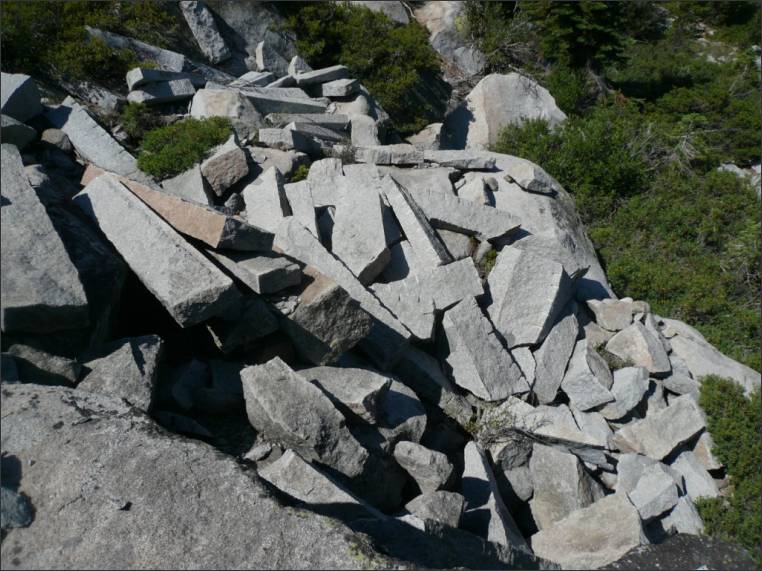
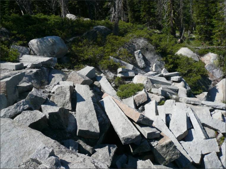
- Cisco (near), Nevada County, California - one of the Central Pacific Railroad Quarries (NOT the Crystal Lake Granite Quarries as previously listed)
Cisco (near), Nevada County, California – the Central Pacific Railroad Granite Quarry located between Cisco & Tunnel 5
(NOTE: This entry was recently moved from the Placer County quarry section to the Nevada County quarry section of our web site because. Peggy B. Perazzo)
(Please note: This quarry was once identified as the “Crystal Lake Quarry” on our web site. Chris Graves and I thought that this quarry was the old Crystal Lake Quarry; but with more research, Chris discovered that the quarry that he visited and photographed was actually a Central Pacific Railroad quarry. Granite from this quarry was used to supply granite for the railroad. Chris wrote that the more recent name of the Crystal Lake Quarry was “Gould and Towle Quarry,” which is listed in the Atlas of the United States No. 66 – Colfax Folio. Another discovery about the Crystal Lake Quarry/Gould and Towle Quarry is that it is located in Nevada County rather than Placer County, as it was described in the articles from the mid-1880s published in Santa Clara County, California. These mid-1880s articles described the Western Granite and Marble Company’s Crystal Lake Quarry as being located in Placer County.)
The following photographs were contributed by G. J. Chris Graves of Newcastle, and they are used with his permission. He indicated that the quarry is located between Cisco and Tunnel 5. According to Chris Graves, Roy Ruhkala (local historian of Rocklin), told him that the Crystal Lake Quarry was opened for the sole purpose of securing granite for Mark Hopkins’ mausoleum – but it turns out this is not the Crystal Lake Quarries. Ruhkala also told Chris Graves that “the Southern Pacific Railroad ran a spur line from the then current grade to the Sacramento Cemetery, this to deliver the stones from Wyoming, the Griffith quarry in Penryn, and the Sierra White granite from this (Central Pacific Railroad) quarry to the mausoleum site (at the Sacramento City Cemetery).”
-
-
Cisco (near), Placer County, California – the Crystal Lake Quarries
See: “Cisco (near), Nevada Placer County, California – Crystal Lake Quarry”


Note: Some early publications indicated that the Crystal Lake Quarry was located in Placer County, but further research has indicated that the quarry was located in Nevada County – just over the Nevada County/Placer County border. Peggy B. Perazzo
- Cisco (south of), Placer County, California – Matthews Limestone Deposit (Limestone) (Excerpts from “Limestone in California,” by Clarence A. Logan, California Journal of Mines and Geology, Vol. 43, No. 3, July 1947, California Division of Mines, San Francisco, California, pp. 175-357. Used with permission, California Department of Conservation, California Geological Survey.)
“Matthews deposit is in secs. 22 and 27, T. 16 N. R 13 E., M.D., 5 ½ miles or more by trail south of Cisco on the ridge between Granite Canyon and North Fork of American River near their confluence, at an elevation of 4000 feet. Vic Matthews reports that analyses of samples indicate the limestone is of good quality. Due to its location, there is little likelihood of it being exploited.”
- Clipper Gap, Placer County, California – Pacific Lime and
Plaster Company Limestone Quarry and Kiln (From The Structural
and Industrial Materials of California, Bulletin No. 38, California,
State Mining Bureau, San Francisco, California, 1906.)
"Pacific Lime and Plaster Company, in Clipper Gap district; limekilns at Benicia, Solano County; D. Edward Collins, Oakland, president; W. O. Badgley, Oakland, general manager, with head office in San Francisco. The company, which began operations in January, 1905, at Clipper Gap, 5 miles northeast of Auburn, purchased 1353 acres within Secs. 16, 20, 21, 29, and 30, T. 13 N., R. 9 E. The extensive limestone deposits lie on the west side of the North Fork of the American River, following the southwesterly course of the river for a distance of 4 miles, extending in some occurrences to the bank of the river and in others a mile to the westward. Mr. Badgley states that the company decided upon the location of the kilns at Benicia because of economy in transportation of the rock, having both rail and water facilities for shipment of the product, and the availability of oil for fuel.
"The same limestone belt is exposed near Murderers' Bar, on the American River. A kiln was erected at the deposit a number of years ago, but was never used."
- Colfax (about 7 miles from), Placer County, California – the Appleton Ranch Marble Quarry (circa 1867) – Excerpts from Mineral Resources of the States and Territories West of the Rocky Mountains, by J. Ross Browne, Report to the Committee on Mines and Mining, House of Representatives During the Second Session of the Fortieth Congress, 1867-1868, Ex. Doc. No. 202, 1868. (This book is available on Google Books.)
“The Colfax Quarries. – The most noted of these was discovered in 1866, in the mountains bordering the Bear river, about two miles to the east of the town of Colfax, Placer county, near the line of the Central Pacific railroad....”
“There is a quarry of nearly white marble recently discovered on the Appleton ranch, about seven miles from Colfax and two miles from the railroad. Some fine blocks have been sent from it to San Francisco.
“Both these quarries are in the limestone belt.”
- Colfax (west of), Placer County, California – Bear River Marble (formerly Holmes Lime & Cement Company) (Marble) (Excerpts from “Limestone in California,” by Clarence A. Logan, California Journal of Mines and Geology, Vol. 43, No. 3, July 1947, California Division of Mines, San Francisco, California, pp. 175-357. Used with permission, California Department of Conservation, California Geological Survey.)
“This was one of the earliest known marble deposits in the state, having been found in 1866. It is a dark gray stone with jet black as well as white veining, and takes a high polish. It was used in considerable quantity in San Francisco for interior work, notably in the old U. S. Mint and Bank of California buildings. Later two kilns were built and lime was burned, but there has been no production for over 30 years. A face 400 feet long was worked. It is on the south bank of Bear River and a tramway 1000 feet long was used to raise stone out of the canyon to the road.”
- Colfax, Placer County, California – the Colfax Marble Quarries circa 1867 – Excerpts from Mineral Resources of the States and Territories West of the Rocky Mountains, by J. Ross Browne, Report to the Committee on Mines and Mining, House of Representatives During the Second Session of the Fortieth Congress, 1867-1868, Ex. Doc. No. 202, 1868. (This book is available on Google Books.)
The Colfax Marble Quarries, Placer County (circa 1867) (pp. 243)
“The Colfax Quarries. – The most noted of these was discovered in 1866, in the mountains bordering the Bear river, about two miles to the east of the town of Colfax, Placer county, near the line of the Central Pacific railroad. The marble differs from all others found on the coast, being a dark gray, with jet black venation. When polished it is very beautiful. The mantels in the new Bank of California are made from this marble, which contributes to the beauty of the interior of that structure.
“The proprietors of the quarry are among the first to derive direct benefit from the Central Pacific railroad, and their case illustrates how great an advantage that road will be in developing the resources of the State. Without such a means of transportation the marble could not be delivered at San Francisco for less than $20 per ton; with it freight is only $8 per ton. The owners of the quarry at Columbia pay $10 per ton for hauling their marble to Stockton when the roads are good, but from $12 to $15 per ton during the winter, with an addition of $2 per ton from that place to San Francisco by water. The expenses for transportation are still higher from the Indian Diggings quarry. Expense of transportation alone has thus far prevented the development of this valuable resource, and cost the State as much for imported marble as would have nearly paid for a railroad to the quarries.
“There is a quarry of nearly white marble recently discovered on the Appleton ranch, about seven miles from Colfax and two miles from the railroad. Some fine blocks have been sent from it to San Francisco.
“Both these quarries are in the limestone belt.”
- Colfax (west of), Placer County, California – Holmes Limestone
Quarries and Limekilns (Limestone, Marble, & Kilns) (From The Structural
and Industrial Materials of California, Bulletin No. 38, California,
State Mining Bureau, San Francisco, California, 1906.)
"Holmes Limekilns, in Sec. 33, T. 15 N., R. 9 E.; The Holmes Lime Company, 24 Sacramento street, San Francisco, owner. The works are on the east bank of Bear River, 2 miles west of Colfax. The quarry was operated for eight months in 1904, burning lime in one of the two kilns. This limestone was first quarried in 1870 for marble. (See under 'Marble.') The exposure in the quarry is 200 feet wide and 50 feet high. About 2000 feet north the ledge crops for a length of 100 feet over a width of 40 feet. The general dip is to the east. There are 46 acres in the holding, including quarry, kilns, tramway, Pelton wheelhouse, reservoir tank, and storage house. The kilns are updraft, of 6 tons daily capacity each, though they have not been operated beyond 5 tons. Wood is used for fuel. The tramway for carrying the lime from kilns to the storage house is 1000 feet long, at an inclination of 40 degrees, and operated by a 24-inch Pelton waterwheel."
"Holmes Lime Company's Quarry (Marble), in Sec. 33, T. 15 N., R. 9 E.; Holmes Lime Company, San Francisco, owner. (See Limestone.) Thirty-five years ago marble was sawed and polished from this limestone ledge by a man named Pritchard, who made the marble columns for the entrance way to the Napa Insane Asylum and tiling for the floor of the San Francisco branch mint building."
(Also see: Colfax (west of), Placer County, California – Bear River Marble .)
- Cool, Placer County, California – Limestone Quarry and Kilns
(From Geologic Guidebook Along Highway 49 - Sierran Gold Belt: The
Mother Lode Country, Bulletin 141, Olaf P. Jenkins, Chief, California
Division of Mines, San Francisco, California, 1949. Used with permission,
California Department of Conservation, California Geological Survey.)
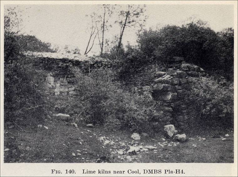
"Five miles north of Baileys near the site of Cool are some old lime kilns which operated in the 'sixties. The two kilns on the right side of the road have straight faces and curved sides. They are constructed of dressed limestone blocks and lined with quarried meta-andesite which was more heat resistant (Fig. 140). The ruins of several building foundations made of the same limestone which was burned in the kilns are nearby, and the quarry pit may be clearly seen. Just beyond is the modern (circa 1948) Cragco Company quarry."
Fig. 140. Lime kiln near Cool, DMBS Pla-H4 
- Crystal Lake, Placer County, California – the Western Granite & Marble Company’s Granite Quarries at Crystal Lake circa 1893
See “Cisco (near), Placer County, California – the Western Granite & Marble Company’s Granite Quarry at Crystal Lake circa 1893” above.
- Emigrant Gap, Placer County, California – (Unnamed) Granite
Quarry (From The Structural and Industrial Materials of California,
Bulletin No. 38, California, State Mining Bureau, San Francisco,
California, 1906.)
"Emigrant Gap. T. 17 N., R. 12 E. There is a large exposure of granite in the extreme northwestern part of Placer County; reported to be of excellent building variety. This material was used in the construction of the dam that forms Lake Spaulding, which has an area of 240 acres and conserves 52 feet of water above the gate."
- "Gold
rush by-products help shape county landscape," by Janice
Kelley, Discover Magazine, Sacramento Bee (photograph and history).
This article includes Placer County quarries in general and information
on the Griffith Quarry. (The web address is no longer available.)
<http://www.sacbee.com/ourtown/discover/placer/history.html> - Hotaling Quarry, Placer County, California – the Hotaling
Quarry (Marble) (From The Structural and Industrial Materials
of California, Bulletin No. 38, California, State Mining Bureau,
San Francisco, California, 1906.)
"Hotaling Quarry, in Sec. 16, T. 13 N., R. 8 E. White marble occurs near Hotaling, 5 miles north from Clipper Gap. It has been used only as flux for the smelting of iron by the California Iron and Lime Company."
- Clipper Gap (west of), Placer County, California – Hotaling Marble Deposit (Marble) (Excerpts from “Limestone in California,” by Clarence A. Logan, California Journal of Mines and Geology, Vol. 43, No. 3, July 1947, California Division of Mines, San Francisco, California, pp. 175-357. Used with permission, California Department of Conservation, California Geological Survey.)
“Hotaling Deposit. There is a small deposit of white saccharoidal marble at the Hotaling iron mine, in sec. 15, T. 13 N., R. 8 E., M.D., 3 ½ miles west of Clipper Gap. This was used at the iron smelter operated on the mine in the eighties, and some of it was shipped to San Francisco for making carbonated water. According to an old analysis, it is nearly pure calcium carbonate.”
- Clipper Gap (west of), Placer County, California – Hotaling Marble Deposit (Marble) (Excerpts from “Limestone in California,” by Clarence A. Logan, California Journal of Mines and Geology, Vol. 43, No. 3, July 1947, California Division of Mines, San Francisco, California, pp. 175-357. Used with permission, California Department of Conservation, California Geological Survey.)
- Hotaling, Placer County, California – Dorothy R. Wold and Chas. Pennington (Limestone Deposit) (From “The Cool-Cave Valley Limestone Deposits, El Dorado and Placer Counties, California,” by William B. Clark, Junior Mining Geologist, California Division of Mines, California Journal of Mines and Geology, Vol. 50, Nos. 3 and 4, July-October 1954, pp. 439-466. (Used with permission, California Department of Conservation, California Geological Survey.)
“At Hotaling, 3 ½ miles west of Clipper Gap is a small deposit of coarse, white, granular limestone. This was used at the iron smelter operated at Hotaling in the 1880’s (Logan, 1947, p. 264).”
The following information is taken from “Table 1. Limestone deposits in the general area of the Cool-Cave Valley limestone,” (circa 1954) on pages 462 and 463:
(No. on map, Plate 3) 8; (Deposit) Hotaling; (Owner) Dorothy R. Wold and Chas. Pennington, 32 Overhill Road, Orinda; (Location) Sec. 15, T. 13 N., R. 8 E., M.D.; (References) Hanks, 84:110; Logan 27:281; 47:264; Bowen and Crippen 48:73.
- Lime Rock (northwest of), Placer County, California – Eleanor DeWitt (Limestone Deposit) (From “The Cool-Cave Valley Limestone Deposits, El Dorado and Placer Counties, California,” by William B. Clark, Junior Mining Geologist, California Division of Mines, California Journal of Mines and Geology, Vol. 50, Nos. 3 and 4, July-October 1954, pp. 439-466. (Used with permission, California Department of Conservation, California Geological Survey.)
“The DeWitt deposit is about half a mile northwest of Lime Rock just north of Clipper Creek. It is 250 feet long and varies from 50 to 100 feet in width. Six samples taken from this deposit were analyzed by Abbot A. Hanks, Inc.”
The following information is taken from “Table 1. Limestone deposits in the general area of the Cool-Cave Valley limestone,” (circa 1954) on pages 462 and 463:
(Deposit) Dewitt; (Owner) Eleanor DeWitt, 1931 C Street, Sacramento; (Location) Sec. 30, T. 13, R. 9 E., M.D.; (References) Tucker 19:391; Logan 27:282; 47:264.
- Lime Rock (southeast of), Placer County, California – Muegge Limestone Deposit (Limestone) (Excerpts from “Limestone in California,” by Clarence A. Logan, California Journal of Mines and Geology, Vol. 43, No. 3, July 1947, California Division of Mines, San Francisco, California, pp. 175-357. Used with permission, California Department of Conservation, California Geological Survey.)
“Muegge Deposit. Theodore C. Muegge, 450 Sutter Street, San Francisco, is the owner. It is in S ½ sec. 29, T. 13 N., R. 9 E., M.D., on the south side of North Fork dam, 8 miles by road from Auburn.
“The limestone is 225 feet wide at the water’s edge but the outcrop is exposed for only a short distance up the slope to the south and backs are negligible.”
- Lime Rock (southeast of), Placer County, California – Muegge Limestone Deposit (Limestone) (From “The Cool-Cave Valley Limestone Deposits, El Dorado and Placer Counties, California,” by William B. Clark, Junior Mining Geologist, California Division of Mines, California Journal of Mines and Geology, Vol. 50, Nos. 3 and 4, July-October 1954, pp. 439-466. (Used with permission, California Department of Conservation, California Geological Survey.)
“Lime Rock, a well-known landmark of the area, stands out prominently from the surrounding metavolcanics and metasediments. On the north end, the deposit rises 70 feet above the land surface, while at the south end the face extends at least 500 feet down the slope toward the North Fork Dam. The deposit is about 150 feet wide and 300 feet long….”
“Southeast of Lime Rock on the south side of North Fork reservoir is the Muegge deposit which is partly covered by water. Although it is 225 feet wide at the water’s edge, it extends for only a short distance up the slope.”
The following information is taken from “Table 1. Limestone deposits in the general area of the Cool-Cave Valley limestone,” (circa 1954) on pages 462 and 463:
(No. on map, Plate 3) 12; (Deposit) Muegge; (Owner) T. C. Muegge, 450 Sutter Street, San Francisco; (Location) Sec. 29, T. 13 N., R. 9 E., M.D.; (References) Logan 47:265.
- Lime Rock (southeast of), Placer County, California – Muegge Limestone Deposit (Limestone) (From “The Cool-Cave Valley Limestone Deposits, El Dorado and Placer Counties, California,” by William B. Clark, Junior Mining Geologist, California Division of Mines, California Journal of Mines and Geology, Vol. 50, Nos. 3 and 4, July-October 1954, pp. 439-466. (Used with permission, California Department of Conservation, California Geological Survey.)
- Lime Rock, Placer County, California – Pacific Portland Company/Lime Rock Limestone Deposit (Limestone & Kiln) (Excerpts from “Limestone in California,” by Clarence A. Logan, California Journal of Mines and Geology, Vol. 43, No. 3, July 1947, California Division of Mines, San Francisco, California, pp. 175-357. Used with permission, California Department of Conservation, California Geological Survey.)
“Pacific Portland Cement Company, 417 Montgomery Street, San Francisco, own over 800 acres of land in sections 20, 21, 29, 30 and 31, T. 13 N., R. 9 E., M.D., on which are several deposits of limestone. Much of this land once belonged to Pacific Lime and Plaster Company, and a number of lime kilns have been operated in years past, but all of them have long been idle.”
“Lime Rock deposit is near the line between sections 29 and 30 but probably in SE ¼ sec. 30, T. 13 N., R. 9 E., 2.15 miles by old road on an easy grade from Clipper Gap station on the Southern Pacific Railroad. It is a prominent outcrop on the steep slope on the north side of the North Fork debris dam. The quarry opened here years ago is from 60 to 120 feet long from north to south and 140 feet wide from east to west. Work started in 1905 and limestone is believed to have been shipped to Benicia, but there are also the remains of a lime kiln nearby. (The last recorded lime production in the county was in 1910.) The remaining part of the outcrop rises 55 feet above the quarry floor, with a thickness of 50 feet. The extension northward is limited, but the steep face of limestone extends vertically at least 50 feet down the south slope toward the dam.
“It is believed that the limestone in several of the deposits belonging to the company in the vicinity is similar in character, and a sample was taken across a width of 50 feet at this old quarry level, to get an idea of their quality. Analysis of this was reported as follows by Abbot A. Hanks, Inc.
Insoluble, 0.46 percent
Ferric oxide and aluminic oxide, 0.63 percent
Calcium carbonate, 98.5 percent
Magnesium carbonate, 0.40 percent
Total, 99.99 percent
“This limestone is dark gray, some being very fine grained. It weathers only a shade lighter than the color of the fresh stone. Like all other similar deposits, it is a fetid limestone. This is reported to be one of the few limestone deposits of the region that has yielded any fossils. If it maintains the same cross-section to 500 feet in depth, the deposit should contain 700,000 tons.
“Another deposit under the same ownership is 4.2 miles by road south of Applegate station on the Southern Pacific Railroad. It is in W ½ sec. 21 T. 13 N., R. 9 E., and has been partly eroded away by the North Fork of American River, with the remaining parts separated by the North Fork debris dam, so that the part east of the dam is not accessible from Applegate, but may be reached from the Auburn-Forest Hill road. By that road it is about 10 miles from railroad.
“The old private road to the western part of deposit, which connects with the county road to Applegate, is in fair condition. It rises 825 feet in 2 ½ miles. On this side, the limestone shows a width of 300 feet at the old lime kiln (1000 feet elevation) and has backs of about 400 feet above the level of the dam. Only a small amount of the stone has been quarried, although it appears to be of good quality. There is a large tonnage on the east side of the dam, and this is said to have been extensively prospected and sampled.
“About 0.1 mile east, on the west side of (the North Fork debris) dam, there is an outcrop of limestone 80 feet wide but of small surface area. At Long Point, about on the north line of section 21, is a cherty limestone outcrop.
“No attempt to estimate the total tonnage was made but the amount of high-grade limestone on the west side of dam and accessible from the road mentioned would be of the order of a million tons, and the amount east of dam is greater.
“The north end of the large deposit which was productive at the Mountain Quarries in El Dorado County, extends into Placer County. The Middle Fork of American River has eroded this part of the deposit so that no such favorable conditions exist as were found on the El Dorado County side, although there may be a very substantial tonnage below the river level. This part of the deposit extends for about three-eigths of a mile from the river bed to a place on the steep canyon slope only a little above the present-Auburn-Forest Hill road. Total backs above the river are about 300 feet, but the road would prevent working all of it. It is 5 miles by road from Auburn (Railroad Street) station.
“The road traverses limestone for a diagonal distance of 228 feet, but the actual width of limestone underground is probably about 160 feet. It was possible to sample a continuous width of 100 feet. This is dark gray, medium-grained, compact and fairly tough limestone, containing enough organic matter to give a faint fetid odor when hammered. The following analysis was reported by Abbot A. Hanks for this sample:”
Insoluble, 0.79 percent
Fe2O3 and Al2O3 , 0.59 percent
CaCO3 , 97.44 percent
MgCO3 , 0.29 percent- Lime Rock, Placer County, California – Pacific Portland Cement Company (Limestone Deposit) (From “The Cool-Cave Valley Limestone Deposits, El Dorado and Placer Counties, California,” by William B. Clark, Junior Mining Geologist, California Division of Mines, California Journal of Mines and Geology, Vol. 50, Nos. 3 and 4, July-October 1954, pp. 439-466. (Used with permission, California Department of Conservation, California Geological Survey.)
The following information is taken from “Table 1. Limestone deposits in the general area of the Cool-Cave Valley limestone,” (circa 1954)on pages 462 and 463:
(No. on map, Plate 3) 9; (Deposit) Lime Rock; (Owner) Pacific Portland Cement Company, 417 Montgomery Street, San Francisco; (Location) Sec. 30, T. 13 N., R. 9 E., M.D.; (References) Tucker 19:391; Logan 47:265.
- Lime Rock, Placer County, California – Pacific Portland Cement Company (Limestone Deposit) (From “The Cool-Cave Valley Limestone Deposits, El Dorado and Placer Counties, California,” by William B. Clark, Junior Mining Geologist, California Division of Mines, California Journal of Mines and Geology, Vol. 50, Nos. 3 and 4, July-October 1954, pp. 439-466. (Used with permission, California Department of Conservation, California Geological Survey.)
- Lincoln, Placer County, California – the Byrne Bros. (Granite),
M. Byrne, owner (No exact location given.) (From The Structural
and Industrial Materials of California, Bulletin No. 38, California,
State Mining Bureau, San Francisco, California, 1906.)
Byrne Bros. Granite Quarry, located at Lincoln, owned by M. Byrne.
- Lincoln, Placer County, California – the S. Casperi (Granite),
S. Casperi, Box 91, owner (No exact location given.) (From The
Structural and Industrial Materials of California, Bulletin No. 38,
California, State Mining Bureau, San Francisco, California, 1906.)
S. Casperi Granite Quarry, located at Lincoln, "Box 91."
- Long Point, Placer County, California – Pacific Portland Cement Company (Limestone Deposit) (From “The Cool-Cave Valley Limestone Deposits, El Dorado and Placer Counties, California,” by William B. Clark, Junior Mining Geologist, California Division of Mines, California Journal of Mines and Geology, Vol. 50, Nos. 3 and 4, July-October 1954, pp. 439-466. (Used with permission, California Department of Conservation, California Geological Survey.)
The following information is taken from “Table 1. Limestone deposits in the general area of the Cool-Cave Valley limestone,” (circa 1954) on pages 462 and 463:
(No. on map, Plate 3) 11; (Deposit) Long Point; (Owner) Pacific Portland Cement Company, 417 Montgomery Street, San Francisco; (Location) Sec. 21, N. 13 N., R. 9 E., M.D.; (References) Logan 48:266.
(No. on map, Plate 3) 13; (Deposit) Pacific Portland Cement; (Owner) Pacific Portland Cement Company, 417 Montgomery Street, San Francisco; (Location) Secs. 21, 28; T. 13 N., 9 E., M.D. (References) Aubury 06:74; Logan 27:281; 47:265-266.
- Loomis, Placer County, California – in one of the Loomis Granite Quarries – Excerpts from “A Story of Transition,” in The Overland Monthly, San Francisco: The Overland Monthly Publishing Company, No. 420 Montgomery Street, Vol. XVII (Second Series), No. 93, January 1891, pp. 1-20. (This magazine is available on Google Books.)
“Auburn of today is at once a reminiscence and a promise. It is passing through a period of transition; undergoing the same change from mining to agricultural activity that the State has already undergone. The change is coming more slowly about Auburn; the mining industry is passing into the background more slowly, the agricultural interests are more backward in being developed. Yet here, on a comparatively small scale and compactly, one may study the process of change that the State has seen.
“The spirit of the earlier days still hovers over the town. One is continually reminded of the era of gold, when the very streets yielded up their store of the precious metal, when the old Auburn River, now a noisy little brook dashing over its stony bed and babbling stories of its former glory, was a scene of busy excitement, and the rocker and long tom were as familiar as are now the bright blossoms that line its banks.
“But this activity is a thing of the past, and one is reminded of it as the odor of roses borne on the breeze conjures up visions of gardens. The spirit of the early mining is in the atmosphere, one feels it in the air he breathes, but the substance is no longer there. As you walk through the streets there is scarcely an echo of the busy mining town of early days: the mad excitement of the search for gold has passed away. Perhaps the struggling mass of humanity paused in their greedy search for a moment to gaze upon their surroundings, and the enchantment of the scene cast a spell upon them that made them forget their rockers, and their gravel, and the shining specks of wealth that glistened in their pans....”


“Mouth of Alabaster Cave”
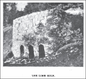
“The Lime Kiln”
“...The soil about Auburn is of a reddish color, owing to the large proportion of peroxide of iron, – that about Loomis and Newcastle more of a grayish, owing to the granite basis.
“Throughout the whole country from Newcastle southerly immense granite bowlders crop out, and the soil is largely mixed with the elements of the decomposed granite. Sheltered from the winds by the surrounding hills, and situated above the frost belt, the heat is sufficient to ripen the fruit early, and the granite bowlders, absorbing heat through the day and giving it out at night, secure an ideally even temperature....”
“About Penryn and Loomis the granite is being quarried, and the finest quality of building stone is produced. At the former place Mr. Griffith began to quarry the stone twenty-three years ago, and one is surprised at the apparent extravagance of a roadside drinking trough for animals carved from a solid block of granite, and the handsome store made entirely of gray and black granite near the railroad station. But granite is more plentiful than lumber, the supply is practically unlimited, and all that it costs is the labor of quarrying and dressing. From the granite quarried here the dry dock at Mare Island, the largest and handsomest on the Coast, was built, and every large city of California has buildings of granite from this county.

“In the Loomis quarry”
“As we leave this favored spot of nature it is with feelings of regret we cast a last glimpse at picturesque Auburn, at busy little Newcastle with its cornucopia of golden fruit, at sleepy Ophir with its mines, at Loomis and Penryn with their granite quarries; and then we close our eyes, and looking into the future see the whole country covered with orchards and vineyards laden with golden oranges and purple grapes, with mammoth peaches and cherries; we see the fig and the apple, the pear and the olive, the pine and the palm, interlocking their branches in this wondrous land where everything grows; we breathe the invigorating air, and feel that we, like the miners of old, have been under the spell of the country; and we hope for the time when the people will shake off their inertia, and will gather the gifts that nature has showered upon them so plenteously, and then the transition will be complete.
“F. I. Vassault.”
- Loomis, Placer County, California – Carlaw Bros. Quarry (Granite) (From Report XV of the State Mineralogist, Mines and Mineral Resources of Portions of California, Chapters of State Mineralogist’s Report Biennial Period 1915-1916, Part III. The Counties of El Dorado, Placer, Sacramento, Yuba, California State Mining Bureau, 1919, pp. 271-459. Used with permission, California Department of Conservation, California Geological Survey.)
At the time the field work was done for this report in October and November, 1915, this quarry was listed as being idle.
- Loomis (near), Placer County, California – the
Western Granite & Marble Company’s Granite Quarries
not far from Loomis (The following article is from
the San Francisco Chronicle, Sunday, April 23, 1893,
pp. 16.)
“Monuments in Stone: The Output of a San Jose Manufactory”
One of Santa Clara County’s Public Buildings – A Stately Tomb.
“One of the big industries of San Jose, and in fact one that is known the whole length of the Pacific coast, is that of the Western Granite and Marble Company. This company was organized with a capital stock of $100,000 only about three years ago. From its very interception the enterprise met with success. Behind it were wide-awake, energetic business men, who whenever the opportunity presented, pushed in and established themselves. During the past year their business has increased almost 100 per cent; to-day they are giving employment to over 100 skilled mechanics, and they are producing some of the handsomest work in stone and marble to be found in the country. In all parts of the State they are rearing piles of masonry which will stand for ages as monuments of their skill and enterprise….”
(Photo caption: “Western Granite and Marble Co., San Jose .”)
“The Western Granite and Marble Company has extensive quarries in Santa Clara and Placer counties. From its great sandstone quarry, seven miles out from San Jose, is obtained the finest quality of stone for facing and dressing purposes. The company’s granite quarries are in Placer county. Not far from Loomis, in two quarries, they have granite in almost inexhaustible quantity. They own another great granite quarry at Crystal Lake. Besides these native stones the company is its own importer of Italian, Vermont and Tennessee marbles and fine Italian statuary. They also handle in large quantities all kinds of American, Scotch and Swedish granites….”
- Loomis Station (south of Penryn), Placer County, California – Rocklin
Granite Company Granite Quarry (Granite) (From The Structural
and Industrial Materials of California, Bulletin No. 38, California,
State Mining Bureau, San Francisco, California, 1906.)
"At Loomis Station, 3 miles south of Penryn, about midway between Penryn and Rocklin, is a granite quarry operated by the Rocklin Granite Company, S. L. Delano, president, Builders' Exchange, San Francisco. The quarry is on a short spur of the Central Pacific Railroad, about half a mile south of the town of Loomis, and on the east side of the railway and wagon road. The quarry opening is on a nearly level area, and is about 100 feet long, 50 feet wide, and from 50 to 60 feet deep.
"The west end of the quarry is a massive block of granite, about 50 feet square, which forms the side wall of the quarry. There are no vertical seams, except those on each side of the mass, and no horizontal seams except a few cracks not continuous but indicating a cleavage in that direction. The east end of the quarry shows several vertical seams 10 to 12 feet apart.
"The Loomis stone is a biotite granite that has less biotite (black mica) than the Penryn stone, and hence a lighter color. In color and texture, as well as in geographic position, it stands between Rocklin and Penryn granite, being coarser and darker than the Rocklin, but not so coarse or dark as the Penryn stone. Like the others, it has a straight cleavage, and splits with an even, regular surface.
"In places in the Loomis region solid granite occurs on the surface, but in most places the solid rock is covered with a varying thickness of disintegrated material, which at the quarry opening is from 3 to 10 feet deep below the surface. The quarry at Loomis, it is said, is not in operation continuously, but is worked at intervals to fills special orders. At present (about 1906) the owners are shipping stone to San Francisco for the extension which is being made to the Hibernia Bank Building."
- Newcastle (near), Placer County, California – the Holmes Lime Company (Limestone) (Excerpt from Report XV of the State Mineralogist, Mines and Mineral Resources of Portions of California, Chapters of State Mineralogist’s Report Biennial Period 1915-1916, Part III. The Counties of El Dorado, Placer, Sacramento, Yuba, California State Mining Bureau, 1919, pp. 271-459. Used with permission, California Department of Conservation, California Geological Survey.)
“The Holmes Lime Company owns a lime quarry near Newcastle but it has been idle the past few years. H. W. Postlewaite, president, 380 Monadnock Building, San Francisco.”
- North Fork Debris Dam (west side of), Placer County, California – Pacific Portland Cement Company/Lime Rock Limestone Deposit (Limestone Deposit) (Excerpts from “Limestone in California,” by Clarence A. Logan, California Journal of Mines and Geology, Vol. 43, No. 3, July 1947, California Division of Mines, San Francisco, California, pp. 175-357. Used with permission, California Department of Conservation, California Geological Survey.)
“About 0.1 mile east, on the west side of (the North Fork debris) dam, there is an outcrop of limestone 80 feet wide but of small surface area. At Long Point, about on the north line of section 21, is a cherty limestone outcrop.
“No attempt to estimate the total tonnage was made but the amount of high-grade limestone on the west side of dam and accessible from the road mentioned would be of the order of a million tons, and the amount east of dam is greater.”
(Also see: Lime Rock, Placer County, California – Pacific Portland Company/Lime Rock Limestone Deposit (Limestone & Kiln) above.)

Commercial use of material within this site is strictly prohibited. It is not to be captured, reworked, and placed inside another web site ©. All rights reserved. Peggy B. and George (Pat) Perazzo.