
List of Quarries in Alaska & Quarry Links, Photographs and Articles
- Marble Island, Alaska – the Marble Island Marble
Deposits (circa 1907) (Marble) Excerpt from “The
Building Stones and Materials of Southeastern Alaska,” by
Charles W. Wright, in Mineral Resources of Alaska: Report
on Progress of Investigations in 1907, Bulletin 345,
by Alfred H. Brooks and Others, Department of the Interior,
United States Geological Survey, 1908, pp. 121.
Marble Island.
“Marble Island, a low wooded area of 9 square miles, is one of the larger islands in Davidson Inlet and lies 10 miles due south of Shakan, though by water it is nearly 30 miles distant. On the northwest side of this island marble was first discovered in 1899, and in 1903 a number of claims were located over this portion of the island and a small amount of stripping was done. Samples of this marble were quarried for test purposes and several varieties of good quality obtained. The total developments have not exceeded the assessment requirements.
“The marble deposit is exposed in a cove on the northwest side of the island, and half a mile from the shore, at an elevation of 100 feet, it has been worked by an open cut. A considerable area is underlain by marble, though little is known of its extent or value. Along the eastern shore of the island an area of granitic intrusive rock was noted.”
- Marble Island, Alaska – Marble Island Marble
Quarries (circa 1907/1908) (Marble) Excerpt from “Building
Stones,” The Ketchikan and Wrangell Mining Districts
of Alaska, Bulletin 347, by Fred Eugene Wright and Charles
Will Wright, Department of the Interior, United States Geological
Survey, Washington: Government Printing Office, 1908, pp.
196.
Marble Island.
“Marble Island, a low wooded area of 9 square miles, is one of the larger islands in Davidson Inlet, and lies 10 miles due south of Shakan, though by water it is nearly 30 miles distant. On the northwest side of this island marble was first discovered in 1899, and in 1903 a number of claims were located over this portion of the island and a small amount of stripping was done. Samples of this marble were quarried for test purposes and several varieties of good quality obtained. The total developments have not exceeded the assessment requirements.
“The marble deposit is exposed in a cove on the northwest side of the island, and at 100 feet elevation, a half mile from he shore, it has been worked by an open cut. A considerable area is underlain by marble, though little is known of its extent or value. Along the eastern shore of the island an area of granitic intrusive rock was noted.”
- Marble Island, Alaska – the Marble Quarrying
on Marble Island (circa 1908) (Marble) Excerpt from “Building
Stones and Materials,” Mineral Resources of Alaska:
Report on Progress of Investigations in 1908, Bulletin 379,
By Alfred H. Brooks and Others, Department of the Interior,
United States Geological Survey, 1909, 85.
“Small explorations are reported to have been made on the Marble Island and Tokeen Bay marble deposits in Davidson Inlet.”
- Marble Island, Alaska – Marble Island Marble
Quarries (circa 1907/1908) (Marble) Excerpt from “Building
Stones,” The Ketchikan and Wrangell Mining Districts
of Alaska, Bulletin 347, by Fred Eugene Wright and Charles
Will Wright, Department of the Interior, United States Geological
Survey, Washington: Government Printing Office, 1908, pp.
196.
- Marble Island, Alaska – Map
showing marble deposits examined on northern Prince
of Wales Island and on Kociusko, Marble, Orr,
and Heceta islands (circa 1920) (Marble) (Excerpt
from Mineral Resources of Southeastern Alaska, Bulletin
682, by Ernest F. Burchard, U. S. Geological Survey, 1920)
Plate III. Map showing marble deposits examined on northern Prince of Wales Island and on Kociusko, Marble, Orr, and Heceta islands (Alaska). From Coast and Geodetic Survey charts Nos. 8200 and 8150. (pp. 28) 
- Marble Island (South), Glacier Bay, Alaska – Marble
Deposit on South Marble Island (circa 1920) (Marble) (Excerpt
from Mineral Resources of Southeastern Alaska, Bulletin
682, by Ernest F. Burchard, U. S. Geological Survey, 1920)
“South Marble Island (No. 7) is similar in character to North Marble Island but is a trifle longer, being about three-fifths of a mile in length. (See fig. 1.) The maximum width is less than half the length, and at one place the island is nearly cut in two at high tide. The maximum height probably does not exceed 250 feet. The marble here is mostly medium-grained white stone, although there is a little veined with gray and a little that is brecciated. A few small inclusions of fine-grained nonmetamorphosed limestone were noted. A thin section examined by T. N. Dale showed a range in grain diameter of 0.025 to 0.75 millimeter, mostly from 0.125 to 0.5 millimeter, with an estimated average of 0.146 millimeter. According to the Rosiwal method the grain diameter averages 0.0077 inch, or 0.196 millimeter. The texture is even, and very little pyrite was noted. The marble takes a good polish. The rock is cut by a few dikes of diabase ranging from less than 1 foot to 3 or 4 feet in thickness. The general strike is north. Joints cut the rock in several directions and are so numerous as probably to interfere with quarrying the marble at the surface. It is possible, however, that all of them may not extend to great depths. Part of the surface is bare and part is covered to a depth of a few inches to 3 feet with glacial debris supporting a growth of mossy turf and shrubs. There is some shoal water in the vicinity of South Marble Island.”
- Marble Island, Alaska – Marble Developments on
Marble & Orr Islands (circa 1920) (Marble) (Excerpt
from Mineral Resources of Southeastern Alaska, Bulletin
682, by Ernest F. Burchard, U. S. Geological Survey, 1920)
Marble and Orr islands - General Features.
“The most extensive developments of marble in southeastern Alaska are in the northwestern part of Marble Island, one of the larger islands in Davidson Inlet, on which marble was first discovered in 1899. Quarrying has been begun on Orr Island, just across the narrow inlet from Marble Island.
“ Marble Island extends about 3 miles from east to west and about 4 miles from north to south. Its surface is densely wooded and is generally of moderate relief, the highest point noted by the Coast and Geodetic Survey being 1,528 feet above sea level. According to the Wrights,* the rocks of both Marble and Orr islands are classified as limestone and other sedimentary rocks, together with schists and volcanic tuffs, all of Paleozoic age. Much of the limestone in this area has been metamorphosed to a high-grade marble.”
(* Footnote 1, page 66: Wright, F. E. and C. W. The Ketchikan and Wrangell mining districts, Alaska: U. S. Geol. Survey Bull. 347, pl. 1, 1908.)
- Marble Island, Alaska – Marble Quarries (From
Southeastern Coastal Alaska Limestone Terrain (1944), presented
by the Alaska Department of Natural Resources. The information
in the report was taken from a report "Limestones of the Pacific
Northwest," by
Edwin Hodge, industrial raw materials consultant, September 1,
1944, for the Bonneville Power Administration.) (The link from
which this information was obtained is no longer available.)
<http://wwwdggs.dnr.state.ak.us/scan1/mr/text/MR191-08.PDF>"Marble Island, in Davidson Inlet and south of Koscuisko.
"Rocks: Extention of Shakaan belt; developed quarries; associated with Gneisses and Schists.
"Commercial Considerations: Island 3 miles east-west, 4 miles north-south. Elevation 1,328 Feat (sic)."
- Marble Islands, Glacier Bay, Alaska – Marble Deposits on Marble Islands, presented on the Geocaching web site.
- Marble Island, Alaska – Mission-Alaska
Quarry Company Marble Island Quarries (circa 1920) (Marble) (Excerpt
from Mineral Resources of Southeastern Alaska, Bulletin
682, by Ernest F. Burchard, U. S. Geological Survey,
1920)
Mission-Alaska Quarry Co.

This web site ncludes: (photo captions) “Marble Islands, Glacier Bay, Alaska”; “Raw Marble Specimen”; and “El Capitan Marble Quarry, Prince of Wales Island, Alaska.”
-
Marble Island, Tokeen, Alaska – Southeast Alaska’s Marble History: Tokeen Marble, Marble Island, Alaska, presented by Fathom Stone of Whistler, British Columbia.
- Marble Island, Tokeen, Alaska – Historical notes about Tokeen Marble – Alaska Historical Files, Alaska State Library Historical Collections, Bayers, Lloyd H., 1911-1968, Captain Lloyd H. “Kinky” Bayers Collection, 1898-1967, MS 10. (Subjects included on the note cards are: (1) “Marble” Marble discovered on Prince of Wales Island near Shakan; Vermont Marble Co. marble quarries at Shakan and Tokeen; Marble discovered by Vermont Marble Co. at El Capitan Pass; the Tokeen marble plant; (2) “Mines and Mining”: “3. Alaskan (Sitka) History of Alaska Marble (John the Baptist Bay—1874”)
- Marble Island, Tokeen Bay, Alaska – the
Marble Quarrying at Tokeen Bay (circa 1908) (Marble) Excerpt
from “Building Stones and Materials,” Mineral
Resources of Alaska: Report on Progress of Investigations
in 1908, Bulletin 379, By Alfred H. Brooks and Others,
Department of the Interior, United States Geological Survey,
1909, 85.
“Small explorations are reported to have been made on the Marble Island and Tokeen Bay marble deposits in Davidson Inlet.”
- Marble Island, Tokeen, Alaska – Alaska Marble
Quarry Photographs (Marble) (photograph) These
photographs are presented on the United
States Geological Survey Photographic Library.
(photo caption) “Tokeen, Alaska. Diabase dike cutting marble beds on west side of quarry. Circa 1912.”
- Marble Island, Tokeen, Alaska - Tokeen on Marble Island (Scroll down to this section.) presented on the Alaska History & Cultural Studies web site by the Alaskan Humanities Forum. (This section includes information on the southeast Alaskan Indians and the history of the eight marble quarries at Tokeen on Marble Island.)
- Marble Island, Tokeen, Alaska – Tokeen Marble Quarry Photographs in the Talmage Family Collection, ca. 1890’s to 1940, Alaska State Library Historical Collections.
- Marble Island, Tokeen, Alaska – Tokeen Marble Quarry
Photographs in the Alaska Bureau Photograph (23) Albums Collection
1897-1925 (inclusive) created by the Seattle Chamber
of Commerce - Alaska Bureau. The repository of this collection
is the Museum of History & Industry,
Sophie Frye Bass Library, 2700 24th Avenue East, Seattle,
WA 98112, Phone: 206-324-1126
17: Southeast 2, 1899-1920, (bulk 1914-1917) “This album consists largely of images of Wrangell, and views of Alaska Indian villages and totem poles near Ketchikan, on Prince of Wales Island and other southeast islands…. Several images depict the town of Tokeen and Tokeen marble quarry operations on Prince of Wales Island. A few images show the village of Dolomi, and Dolomi Harbor and mine on Prince of Wales Island….”
- Marble Island, Tokeen, Alaska – Marble Quarry at Tokeen, Alaska (Photograph PH001_0211, property of Special Collections & University Archives, University of Oregon Libraries)
- Marble Island, Tokeen, Alaska – Vermont Marble
Company’s Quarries/Properties (circa 1920) (Marble & Limestone) (Excerpt
from Mineral Resources of Southeastern Alaska, Bulletin
682, by Ernest F. Burchard, U. S. Geological Survey, 1920)
Vermont Marble Company’s Properties.
“A group of claims lying on both Marble and Orr islands (No. 35) and crossing Marble Passage, the channel between them, is under development by the Mission-Alaska Quarry Co., of San Francisco, Calif. On Marble Island rocks of two colors occur, one nearly white, and the other grayish blue. The light-colored marble lies south of the blue marble and apparently overlies it, although the stratigraphic relations of the two are not wholly clear. A small bluff of white marble is exposed at the water’s edge almost directly opposite the quarry on Orr Island. This marble is massive and of medium grain for 15 to 20 feet above the water. Higher up the slope the weathered surface shows thick layers, and the grain is somewhat finer. Only a little prospecting has been done here.
“The blue marble crops out in a low swampy tract along the shore about half a mile northeast of the bluff of white marble. It is dense, hard, and fine grained and shows white calcite streaks along bedding and joint planes. It appears to be more nearly a true marble than the thin-bedded blue limestone at Tokeen, which it nevertheless resembles somewhat in character. Weathering has accentuated the bedded character of the rock along exposed edges. The dip of these beds is steep toward the northwest. A little prospecting and sampling have been done on this deposit in the way of assessment work.
“A thin section of the blue marble examined by T. N. Dale appears to be composed of a fine-grained groundmass containing streaks of graphite and crossed by coarse veins. Micrometer measurements showed the groundmass to have a grain diameter ranging from 0.02 to 0.14 millimeter, but mostly between 0.03 and 0.094 millimeter, with an estimated average of 0.04 millimeter. The vein material showed a grain diameter of 0.1 to 1 millimeter, mostly 0.25 to 0.5 millimeter.”
“Workers at marble quarry operating mining machinery and tools. Machinery has wheels and is on metal tracks. Pipelines extend out from the side of the machines. Items such as shovels, ropes, and barrels, are visible. There are seven workers dressed in hats, long sleeved shirts, or jackets, and boots.” Photographer J. E. W.
“Certain marble claims that were located in the northwestern part of Marble Island in 1903 have been purchased by the Vermont Marble Co., which has opened large quarries (No. 33) and built a small village named Tokeen. The total area held by the company aggregates 703 ¼ acres, according to the plat of mineral survey No. 927, made by L. D. Ryus, deputy mineral surveyor of Ketchikan. (See fig. 3.)
(Map title) Figure 3. Sketch map showing claims of Vermont Marble Co. on Marble Island (circa 1920) (Alaska). (pp. 66) “Blue-black limestone. – The marble in the main quarry is massive and has yielded no fossils except crinoid buttons, but it overlies thin-bedded blue-black limestone which has yielded fossils of probable Silurian age, consisting of Merestina sp., Clorinda sp., Conocardium sp., Trochonema sp., Favosites sp., and Cyclonema sp., as determined by Edwin Kirk. of the United States Geological Survey.
“Southwest from the Tokeen wharf, along the shore of the island, an alternation of limestone beds, intrusive rocks, and marble occurs, but the blue-black limestone crops out around the cove in which the wharf is situated, and near the company’s office a small area has been stripped and several blocks of the stone have been taken out. The rock is fine grained and dense but is much fractured and jointed. The openings have been cemented with white calcite. The beds range from 1 foot or less to 3 feet in thickness but on weathering separate into thin layers 1 ½ to 5 inches thick. (See Pl. X, A.) The joints separate the rock in places into small blocks only 1 inch to 3 or 4 inches on an edge. The material takes a fine dark polish. (See Pl. VIII, B.) The rock is very brittle and breaks easily, not only along the calcite-filled joint cracks but also along the laminations parallel to the bedding planes. Probably most of the surface material will have to be rejected, but at greater depth the joint cracks appear to become fewer and the rock tougher. The white calcite streaks that intersect the dark surface produce very attractive effects in the polished stone and it was expected that the material would be quarried and marketed as ‘black marble.’
Pl. VIII. B. Fine-grained black marble (blue-black limestone) from Vermont Marble Co.’s property, Tokeen, Marble Island (Alaska). (pp. 50)
Pl. X. A. Fossiliferous blue-black limestone beds in tramway cut 250 feet from the wharf, Tokeen (Alaska). (pp. 66) “T. N. Dale examined a thin section of this blue-black limestone and found that it consists of calcite, mostly untwinned, measuring with the micrometer 0.009 to 0.094 millimeter, but mostly 0.02 to 0.047 millimeter, and averaging probably about 0.05 millimeter, and is therefore to be classified as of fine grain. The microscope reveals sparse minute opaque specks, probably carbonaceous material, and some cubes of pyrite.
“The overburden consists of forest growth and decayed wood and mold 1 ½ to 3 feet thick. The rocks dip 38° - 40° NE., and the edges of their tilted beds have been cut by solution into a very irregular surface. The tramway from the wharf to the marble quarry passes the opening on the blue-black limestone, so that the material can be handled with a minimum of expense.”
“White and veined marble. – Eastward from Tokeen the blue-black limestone passes beneath the deposit of white marble, which extends to and probably far beyond a small bight on the north side of Marble Island, 400 feet from the quarry. The belt of marble and dark limestone is probably 2,500 feet or more in width, and it extends southeastward into the interior of the island for a much greater distance – possibly nearly white with dark-gray and black veins to light-gray and grayish-blue shades. The grain is medium fine and fairly uniform. The marble having dark veins on a white background is very much in demand at present for interior decoration. Blocks are sawed into slabs, which may be matched so as to form certain nearly symmetrical patterns. Such slabs have been used in a large number of buildings near the Pacific coast. (See ‘Uses of Alaska marble,’ pp. 110-112 and Pls. XVI (p. 78), XXIII (p. 92), XXIV (p. 93), and XXV (p. 94).)
“Thin sections of the marble from Tokeen were studied microscopically by T. N. Dale. A section of the white marble showed a grain diameter of 0.07 to 1.5 millimeters, mostly 0.52 to 0.2 millimeter, with an estimated average diameter of 0.31 millimeter, falling within the limits of medium grain. the texture is very uneven. One section is crossed by a band of very fine untwinned dolomite (?) along which shearing has taken place. (See Pl. VI, B.) A section of the veined white and gray marble, which showed a very uneven texture, includes parts that are extremely fine and parts that are extremely coarse, but in most of the section the grain diameter ranges from 0.025 to 0.625 millimeter, mostly 0.1 to 0.375 millimeter. The Rosiwal measurements gave an average grain diameter of 0.0051 inch, or 0.13 millimeter. The grade is therefore, in general, medium. The rock shows streaks of very fine, untwinned magnesian calcite grains with graphite. A large grain of pyrite 0.4 millimeter in diameter was noted.
“The following determinations made by R. K. Bailey show that the veined marble contains considerable magnesia:


Analyses of white and veined marble from Tokeen.
Insoluble matter – (white) 0.01 (Veined) 0.20
Calcium carbonate (CaCO3) – (White) 99.51 – (Veined) 81.90
Magnesium carbonate (MgCO3) – (White).94 – (Veined) 14.93
“The marble appears to be wholly metamorphosed. The material is massive and shows no indication of its original bedding, but it is much jointed and fractured and within 10 to 20 feet of the surface is rather soft. The joint planes cut the deposit at many angles but may perhaps be referred to several systems, the two principal ones striking about N. 50° E. and N. 40° W. The dips of the joint planes are likewise at many angles, and the spacing of the joints is variable, ranging from a few inches to 10 feet or more. In some places parallel joints, or ‘headings,’ are rather close together, rendering it impossible to obtain blocks large enough for shipment, but elsewhere blocks 4 by 4 by 10 feet free from cracks may be easily obtained. Wedge-shaped blocks that are completely separated from the surrounding mass by smooth joint planes are occasionally encountered in quarrying. Near the northeast side of the main quarry the marble is cut by a dike of altered andesite porphyry, 8 to 16 inches thick, containing much pyrite and dipping 17° - 25° NE. (See Pl. XI, A.).
Pl. XI. A. Andesite porphyry dike about 1 foot thick cutting marble beds on west side of Vermont Marble Co.’s Quarry, Tokeen (Alaska). “The jointed structure of the marble is the most serious hindrance to its profitable exploitation. It is to be expected that joint cracks should be present at the surface and that surface water should descend along these cracks, enlarging them, softening the marble, and oxidizing it to a faint yellowish hue, but according to experience in many other regions it might be expected that at depths of 40 to 60 feet the joint cracks would disappear and the marble become solid. To that depth quarried in 1912 (60 feet), however, it showed joint cracks in places (Pl. XI, B), and it may be possible that the widespread volcanism to which the Pacific coast of northwestern North America has been subjected has disturbed the rocks generally to much greater depths than in other marble-quarrying regions.
Pl. XI. B. Face of marble at depth of about 50 feet in Vermont Marble Co.’s quarry at Tokeen (Alaska) (circa 1920).


“The white marble was also analyzed in the chemical laboratory of the Bureau of Standards, with the following results:
- Marble Island, Tokeen, Alaska – Vermont
Marble Company Properties at Tokeen (circa 1932) (Marble) (From Mineral
Industry of Alaska in 1932, by Philip S. Smith, United
States Geological Survey, Bulletin 857-A, 1934.
“The largest single enterprise that is included under this section is the quarrying of marble by the Vermont Marble Co. from its properties in southeastern Alaska. For many years this company was a large and consistent producer, but later its output decreased, and in 1931 its quarries were idle throughout the year. Resumption of work is therefore regarded as a very favorable indication that the industry will continue to be significant in the general mineral activity of the Territory. The quarries owned by this company are near Tokeen and Calder, on the west coast of Prince of Wales Island, but the finishing plants to which the rough stone is sent are in Tacoma, Wash., and San Francisco, Calif. The stone has been in great demand throughout the west coast and has been used in many of the most imposing buildings, principally for interior trim and decoration. According to the reports of the company only about two thirds of the marble quarried during the year was shipped to its finishing plants, the rest being held at the mine. Limestone and marble are widely distributed throughout southeastern Alaska, and, according to Burchard,* many different grades, some even approaching statuary quality, are found in the region. It therefore seems strange that more of these limestone and marble deposits, many of which are favorably situated with respect to deep-water transportation, have not been profitably developed.”
(* Footnote 33, pp. 74: Burchard, E. F., Marble resources of southeastern Alaska: U.S. Geol. survey Bull. 682, pp. 29-39, 1920)
- Marble Island, Tokeen, Alaska – Vermont
Marble Company Properties at Tokeen (circa 1934 )
(Excerpts from Mineral Industry of Alaska in 1934,
by Philip S. Smith, United States Geological Survey, Bulletin
868-A, Government Printing Office, 1936.)
“…one of the hitherto large mining enterprises is the quarrying of marble by the Vermont Marble Co. from its properties near Tokeen and Calder, in southeastern Alaska. No productive mining was done there during 1934, though the property was kept in condition so that work could be resumed promptly when required. The stone from these quarries is used in most of the larger and better buildings in the whole Pacific coast region, being especially in demand for interior trim and decoration. Ordinarily the company ships its rough stone from Alaska to finishing plants it maintains in Tacoma, Wash., and San Francisco, Calif. There is, of course, no basis for believing that the cessation of quarrying during the year means the permanent closing of the property. It only marks halt in production until sales of the product now on hand deplete the stock so that replacements are needed, and there is every indication that this will occur shortly so that the quarries will again be running. Limestone and marble are widely distributed throughout southeastern Alaska, and, according to Burchard,* many different grades, some even approaching statuary quality, are found in the region. It therefore seems certain that some of these limestone and marble deposits, many of which are favorably situated with respect to deep-water transportation, will ultimately be profitably developed.”
(* Footnote 5, pp. 81: Burchard, E. F., Marble resources of southeastern Alaska: U.S. Geol. Survey Bull. 682, pp. 29-39, 1920)
- Marble Island, Tokeen, Alaska – Vermont
Marble Company Properties at Tokeen (circa 1934 )
(Excerpts from Mineral Industry of Alaska in 1934,
by Philip S. Smith, United States Geological Survey, Bulletin
868-A, Government Printing Office, 1936.)
- Marble Island, Tokeen, Alaska – the Vermont
Marble Company Quarries at Tokeen (circa 1935) (Marble) (Excerpt
from Mineral Industry of Alaska in 1935, by Philip
S. Smith, United States Geological Survey, Bulletin 880-A,
Government Printing Office, 1937.)
“…one of the hitherto large mining enterprises is the quarrying of marble by the Vermont Marble Co. from its properties near Tokeen and Calder, in southeastern Alaska. No productive mining was done there during 1935, though the property was kept in condition so that work could be resumed promptly when required. The general practice of this company has been to operate these quarries actively at intervals and supply all the stone it needed for the ensuing 2 or 3 years, during which time the quarries are kept only in a stand-by condition. The stone from these quarries is used in most of the larger and better buildings in the whole Pacific coat region, being especially in demand for interior trim and decoration. Ordinarily the company ships its rough stone from Alaska to finishing plants it maintains in Tacoma, Wash., and San Francisco, Calif. There is, of course, no basis for believing that the cessation of quarrying during the year means the permanent closing of the property. It only marks a halt in production until sales of the product now on hand deplete the stock so that replacements are needed, and there is every indication that this will occur shortly so that the quarries will again be running. Limestone and marble are widely distributed throughout southeastern Alaska, and, according to Burchard,* many different grades, some even approaching statuary quality, are found in the region. It therefore seems certain that some of these limestone and marble deposits, many of which are favorably situated with respect to deep-water transportation, will ultimately be profitable developed.”
(* Footnote 9, pp. 86: Burchard, E. F., Marble resources of southeastern Alaska: U.S. Geol. Survey Bull. 682, pp. 29-39, 1920)
- Marble Island, Tokeen, Alaska – the
Vermont Marble Company Quarry at Tokeen (circa 1936) (Marble) (From Report
of the Commissioner of Mines to the Governor for the Biennium
Ended December 31, 1936, Territory of Alaska.)
“The quarry of the Vermont Marble Company at Tokeen has remained idle. When in operation this quarry employs from 40 to 70 men.”
-
Marble Island, Tokeen, Alaska – Marble Quarries at Tokeen (1939) (Marble) (Excerpt from The Stone Industries: Dimension Stone, Crushed Stone, Geology, Technology, Distribution, Utilization, by Oliver Bowles, 2nd ed. 1939, pp. 203.)
“Alaska. – Numerous marble deposits in southeastern Alaska have been described by Burchard.* While several companies have operated in various places production has been confined chiefly to Tokeen on Marble Island and Calder on Prince of Wales Island….”
“At Tokeen a deposit about 2,500 feet wide and not far above water level includes white, blue-black, and various shades of gray marbles. They are medium- to fine-grained, take a good polish, and resemble some Italian varieties. Matched slabs having dark veins on a white background are much in demand for interior decoration. A high percentage of waste is occasioned by close and irregular joints.
“All Alaska marbles are shipped by freight steamers to finishing mills on the Pacific coast, the largest being at Tacoma, Wash. To save freight only perfect blocks are shipped. Finished products are marketed chiefly throughout the Pacific Coast States.”
(* Footnote 34, pp. 203: Burchard, E. F., Marble Resources of Southeastern Alaska. U. S. Geol. Survey Bull. 682, 1920, p. 118.)
- Marble Island, Tokeen, Alaska - Vermont Marble Company
Marble Quarry (Marble) (From Southeastern Coastal
Alaska Limestone Terrain (1944), presented by the Alaska Department
of Natural Resources. The information in the report was taken
from a report "Limestones
of the Pacific Northwest," by Edwin Hodge, industrial raw
materials consultant, September 1, 1944, for the Bonneville Power
Administration. (The link from which this information was
obtained is no longer available.)
<http://wwwdggs.dnr.state.ak.us/scan1/mr/text/MR191-08.PDF>"Tokeen, northwest shore. Vermont Marble Company.
"Rocks: Belt 2,500 feet wide extends southeast across Orr Island.
"Dip: 380° - 40° N.E., much jointed, cut by andesite and porphyry dikes.
"Quality: Dark-blue limestone altered to marble; much pyrite."
(The table included in this entry indicates there was white marble and veined marble at the quarry.)
"Commercial Considerations: Quarry near wharf. To Seattle, 826 miles."
- Marble Island, Tokeen, Alaska – Vermont Marble
Company Main Quarry (Marble) (photograph) This photograph
is presented on the United
States Geological Survey Photographic Library.
Photo captions:
“Tokeen, Alaska. Southwest corner of Vermont Marble Company quarry, showing stairway. Wales district, Southeastern Alaska region. Circa 1912.”
“Tokeen, Alaska. Lowest floor of Vermont Marble Company quarry. Wales district, Southeastern Alaska region. Circa 1912.”
“Tokeen, Alaska. Face of marble at depth of about 50 feet in quarry of Vermont Marble Company, showing fracture planes. Wales district, Southeastern Alaska region. Circa 1912.”
“One mile southwest of Tokeen, Alaska. A marble beach on Marble Island. Circa 1912.”
-
Marble Island, Tokeen, Alaska – Vermont Marble Company Quarry – Some of the photographs below presented on Alaska’s Digital Archive are from: “Tokeen – Men at work in marble quarry operated by Vermont Marble Co.,” photographed by C. R. Scothorn, in the C. R. Scothorn Photograph Collection, ca. 1912-1930. ASL-PCA-31 collection; Photograph ID ASL-P31-109.
- Marble Island, Tokeen, Alaska – Vermont Marble Company Quarry – “Tokeen – Men at work in the marble quarry operated by Vermont Marble Co.” Photograph from the C. R. Scothorn Photograph Collection, ca. 1912-1930. ASL-PCA-31; Photograph ID ASL-P31-110.
- Marble Island, Tokeen, Alaska – Vermont Marble Company Quarry – “Office in small building at left; cookhouse and boarding house at right.” Photograph from the C. R. Scothorn Photograph Collection, ca. 1912-1930. ASL-PCA-31; Photograph ID ASL-P31-111.
-
Marble Island, Tokeen, Alaska – Vermont Marble Company Marble Blocks – “Ten men pose with huge blocks of marble. A crane is visible on the right.” Photograph from Alaska State Library Place File. Photographs. ASL. Photograph IDs ASL-Tokeen-5 and ASL-P01-1723.
-
Marble Island, Tokeen, Alaska – “Marble Workers” Identifier: UAF-2005-124-3. Description of postcard in the Tokeen, Alaska, photograph collection presented in Alaska’s Digital Archives: “Postcard shows a few men standing on some railroad tracks. Large block f marble sit in the foreground. A couple of buildings can be seen in the background through the trees.” Circa 1914. (Photograph in the Archives, University of Alaska, Fairbanks.)
-
Marble Island, Tokeen, Alaska – Vermont Marble Company – Photograph of railway used to transport blocks of marble. Photograph from the Alaska State Library Place File. Photographs. ASL collection; Photograph IDs ASL-Tokeen-3 and ASL-P01-1721.
- Marble Island, Tokeen, Alaska – Vermont Marble Company – Photograph of the pier wharf, and blocks of marble – “Tokeen – Marble quarry operated by Vermont Marble Company.” Photograph in the C. R. Scothorn Photograph Collection, ca. 1912-1930. ASL-PCA-31; Photograph ID ASL-P31-112.”
-
Marble Island, Tokeen, Alaska – “Tokeen, Alaska 1914.” From Alaska State Library Place File. Photographs. ASL. Photograph IDs ASL-Tokeen-9 and ASL-P01-3795. Description: “Water view, with rocks in foreground. Buildings, docks, cranes of quarry operation. Blocks of marble are stacked on the wharf. A small passenger vessel is at the dock.” Photograph created by John Elmer Worden, 1861-1925.
- Marble Island, Tokeen, Alaska – Vermont
Marble Company Tokeen & Calder Marble Quarries, Report
by J. G. Shepard, U. S. Bureau of Mines, dated March 1925
(Tokeen & Calder,
Prince of Wales Island, Ketchikan Precinct) in PDF format.
(This report includes 2 photographs that relate to the Vermont
Marble Co. quarries. The photo captions are: “Tokeen
Harbor” and “Marble blocks at dock.” Below
is a transcription of the portion of the report that relates
to the Vermont Marble Company.)
The Vermont Marble Co.
Tokeen and Calder.
Prince of Wales Island.
Ketchikan Precinct.
March 1925
Examined by J. G. Shepard.
U. S. Bureau of Mines.
Location:
The Vermont Marble Co. operates two plants on Prince of Wales Island, Tokeen and Calder. The first is situated on Davidson Inlet and Calder on Shakan straits. Both have excellent deep water harbors which offer no obstacles to ocean going vessels.
Tokeen Plant:
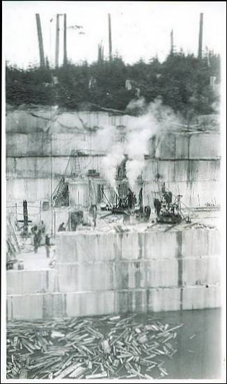
The Tokeen plant is working at full capacity. As operations have only been recently resumed for the season, a large amount of dead work is being necesarily (sic) carried on, in order to place the pits in full producing condition. Four pits are being worked at the main quarry. A derrick is used at each pit. Nine channelers and five burleys are in operation. The lowest point reached at any of the pits is approximately one hundred feet below the surface. At this depth surface joints still presist (sic) and cause a large percentage of waste. Another cause of annoyance and waste is a series of intersection andesite dikes.
One quarter mile north of the main workings a prospect is being floored off. One derrick is being operated and a shore derrick is being erected. Two channelers and one burley are in operation. More equipment will be added as soon as space is cleared.
At the beach two derricks handle the blocks of marble, which are freighted by barge, to Tacoma and San Francisco, for manufacture.
All machinery is run by steam, an aggregate of 450 H.P. being generated by coal fed boilers.
Ninty (sic) men are employed at present at the plant and production should reach 800 tons per month, with the completion of dead work.
A complete machine shop, equipped to care for the simple repairs needed for the quarrying machinery is located half way between the beach and the pits. Lights are generated by a small gas engine, direct (sic) connected to the dynamo.
Calder Plant:
At the Calder plant a small crew of men are engaged in moving machinery and equipment from the quarry operated last year to the pits of old Calder. The prospect operated last season turned out marble, apparently of a good quality, but on attempting to manufacture, it was found to be of insufficient hardness, making it necessary to abandon the prospect. It is hoped that the material fom (sic) the old pits will be found to meet manufacturing requirements.
Conclusion:
It is the intention of the Vermont Marble Co. to continue operations on a large scale and to increase production as much as possible. Business conditions on the Pacific Slope are said to be excellent and Alaska marble is much in demand. The entire situation depends on the grade of marble which can be produced with out exceeding the maximum amount of waste allowable. The waste percentage has been found to be very great, reaching at times, over 70%. Some material of a seemingly good grade is found to be to (sic) soft and unsuitable for manufacture in the facturies (sic).
However, in spite of these handicaps, officials of the Company look forward to a prosperous year in the marble business.
- Marble Island, Tokeen, Alaska -
the Tokeen Marble Quarry
(postcard photograph; mid-1900s; unmailed) 
- Marble Island,
Tokeen, Alaska -
the Tokeen Marble Quarry
(postcard photograph; mid-1900s; unmailed) 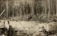
Chemical Analysis of white marble from Tokeen.
Iron oxide (Fe2O3) – Trace
Alumina (Al2O3) – 0.14
Lime (CaO) – 55.80
Magnesia (MgO) -.47
Sulphur trioxide (SO3) – Trace.
Loss – 43.77
Carbon dioxide (CO2) – 43.86
Insoluble residue -.26
Hydrogen sulphides (H2S) – Not detected.
Sample has 99.5 per cent CaCO3.
“The following physical tests were made for the Geographical Survey by the Bureau of Standards on a representative sample of the veined marble from Tokeen. The compression tests show that this marble possesses slightly higher compressive strength than some of the best-known Vermont marbles.*
(* Footnote 1, page 70: “Marble from South Dorset: Average compressive strength per square inch, on bed, 11,300 pounds; on edge, 9,100 pounds. Marble from West Rutland: Compressive strength per square inch, ‘Extra dark blue,’ 13,639 pounds; ‘Rutland Italian,’ 14,068 pounds; ‘Rutland statuary,’ 11,525 pounds. Dale, T. N., the commercial marbles of western Vermont: U. S. Geol. Survey Bull. 521, pp. 101, 121, 1912.”)
“In September, 1912, the top of the quarry opening measured roughly 90 by 100 feet, and the depth ranged from 10 to 60 feet. About one-half of the area had been quarried to the maximum depth. Methods of quarrying commonly in use at well-known marble quarries in the Eastern States are employed. (See Pl. XIII.) The equipment in the main quarry consisted of the necessary drills, seven Sullivan single channeling machines, four gadders and pumps, all operated by steam power generated by a 125-horsepower boiler near the quarry, and a complete machine shop. The blocks of marble are lifted from the quarry by a 25-ton derrick and are carried to the wharf (Pl. XII, B) on flat cars running on a standard-gage track. The loaded cars move by gravity and are drawn back to the quarry by a 7/16-inch steel cable. Waste rock is also trammed down to the wharf and dumped into the water alongside the pier. Deep water is reached by a pier about 150 feet long. A 25-ton stiff-leg derrick for unloading cars and loading marble on boats is operated by a small steam boiler on the shore near the wharf.
Plate XIII. A. Southwest corner showing stairway. Vermont Marble Co.’s Quarry, Tokeen (Alaska).
Plate XIII. B. Lowest Floor. Vermont Marble Company’s Quarry (Alaska).
Plate XII. B. Wharf and water front of Vermont Marble Co.’s property, Tokeen (Alaska). View shows derrick moving blocks of marble. The pile of rock in the water at the right of the wharf is waste marble.
Plate XVI. Panel of Brecciated marble from Tokeen, formed by matching slabs sawed from same block (Tokeen, Alaska). “In September, 1912, a space of 1 ½ acres about 375 feet southeast of the main quarry was being cleared for a new quarry. (See Pl. X, B.) The highest knobs of marble rise here to about 35 feet above the level of the wharf. The marble at this new opening is chiefly white with bluish-gray to black veins and clouds similar to that at the first quarry, but the deposit contains more dark-veined stone. One dike of meta-andesite 1 ½ to 2 feet thick, striking N. 35° W. and dipping 78° SW., was noted. A full equipment (sic) had been installed, and in 1913 and 1914 active quarrying was carried on at this opening, two or three courses of stone having been removed. It is reported that below the surface, as far as quarried, the stone is fairly free from joints and fractures, and a good output of dark-veined marble seems assured.
“About 60 men were employed in connection with this plant in 1912. The men live in sanitary and comfortable dormitories, eat excellent fare at a commodious mess hall, enjoy generally favorable conditions under which to work, and show a high degree of efficiency. Quarrying is carried on for eight months or more each year. The winters are not severe, and operations probably can be carried on throughout most of the year when pipes from a reservoir are laid underground so that there shall be no danger of interruptions by freezing of the water supply.
“Products. – Rough blocks 4 by 4 by 6 to 10 feet are shipped by freight steamers to the mill of the Vermont Marble Co., at Tacoma, Wash., where they are sawed, polished, turned, or planed for interior decoration. To save freight only perfect blocks are shipped, and therefore considerable material is wasted at the quarry. Some of the waste marble is trammed down to the wharf and used as filling. (See Pl. XII, B.) According to the absence or presence of joints the proportion of waste marble quarried may vary between 10 and 75 per cent. The marble for a foot or more on each side of most fractures is discolored and must be cut away. If a fracture crosses the block diagonally or near the middle, it may render the whole block worthless. If cheap power is developed, it might prove an economy to operate a small sawing plant at Tokeen in order to work the waste marble into slabs or building blocks.”
“Other prospects. – The Vermont Marble Co. has prospected claims about 1 mile and 1 ½ miles south of Tokeen (No. 34). At one point a white marble of about the same texture as that at Tokeen, but somewhat shattered, is exposed in a small quarry at the base of a low bluff, where, it is reported, marble was obtained many years ago for making tombstones. The surface marble here has been softened by long exposure to atmospheric agencies, and none from any considerable depth was available.
“At a second place several variegated marbles have been exposed by prospect pits. The most characteristic varieties are colored light to dark green, bluish, mottled light pink, and brownish gray. The mottled character is due to the presence of veins and nodules of fine-grained, dense calcareous material having a cherty appearance. The green varieties are veined with grayish green, darker than the body of the rock. The rock is massive and jointed and is cut by a thin dike of meta-andesite striking N. 40° W. The deposit was prospected by three or four drill holes, 60 to 94 feet deep, which showed that the green stone changed to gray or bluish within 15 to 25 feet from the surface. A small area was next stripped by hand, and two or three shallow pits were opened by a channeling machine, in the hope of developing a supply of desirable green marble. A wooden track on an incline was built from the test pits a short distance down to the water, in order to get out a few sample blocks of stone, and testing operations have been continued from time to time since 1912.
“Between these two prospects there is a beach about 1,600 feet in length, along the greater part of which marble beds are exposed. The marble is veined and is white to grayish. It is cut by several meta-diabase dikes 8 inches to 2 ½ feet thick, some of which are broken and distorted. One dike noted had been faulted and offset horizontally a few feet, but the marble that filled the space between the broken ends of the dike showed only a flowage structure without a definite fault plane. The intrusion of the dike and the deformation of the beds through which it passes probably proceeded the metamorphism that produced the marble.
“Thin sections of two samples of the variegated marble from the deposit 1 ½ miles south of Tokeen were examined by Messrs. Dale and Loughlin. The brownish-gray cherty-appearing material is of very irregular texture. The grain diameter of the finer matrix, which consists of untwined calcite, ranges from 0.025 to 0.075 millimeter, with an estimated average of 0.03 millimeter. The coarser calcitic part shows a grain diameter of 0.05 to 1.125 millimeters, mostly between 0.12 and 0.5, with an estimated average of 0.23 millimeter. Muscovite or phlogopite crystals reaching a length of 0.047 millimeter are widely disseminated. One grain of pyrite 0.7 millimeter in length was noted. A lens of dense dark granular material, cracked and veined with twinned calcite, appears in the section. The texture of the greenish marble was also found to be very irregular. The grain diameter of the finer matrix, most of which is probably untwined calcite, is 0.02 to 0.12, most of the prominent grains ranging from 0.05 to 0.07, with an estimated average of 0.03 millimeter. The grain diameter of the coarser part, which is calcitic, ranges between 0.12 and 0.87 millimeter, with an estimated average of 0.24 millimeter. Much pyrite and a light-brownish mica (biotite) are present throughout the section, and some dark-grayish, very fine grained bands, cracked and veined with calcite, are prominent. These bands contain much fine epidote, scarce hornblende, and possibly some quartz and other silicate minerals not easily susceptible of recrystallization, indicating that the rock stretched and fractured and the relatively pure carbonate rock recrystallized and ‘flowed’ into the stretch fractures.
“The following determinations by R. K. Bailey indicate that there may be some cherty material in the brownish-gray rock:
Analyses of brownish-gray marble from deposit 1 ½ miles south of Tokeen.
Insoluble matter – (Brown rock) 20.77 – (Green rock) 7.82
Calcium carbonate (CaCO3) – (Brown rock) 78.65 – (Green rock) 91.70
Magnesium carbonate (MgCO3) – (Brown rock) 1.87 – (Green rock) 1.21
“Limestone, slightly metamorphosed in places but generally a fine-grained bluish rock much fractured and seamed with calcite, alternating with graywacke, forms the coast line around most of the west and south sides of Marble Island. A considerable area of true marble, however, occurs along the middle of the east side of the island and on the west side of Orr Island, which is separated by a narrow channel from Marble Island.”
Plate XXIII. Entrance to Yeon Building, Portland, Oregon, decorated with Tokeen Marble (Alaska). Note the matched panels produced by sawing slabs of clouded marble.
Plate XXIV. Corridor, University of Utah, Salt Lake City, Utah, decorated with Tokeen marble (Tokeen, Alaska).
Plate XXV. Lobby of Isaacs Building, Los Angeles, Calif.; floors, stairs, and walls of Tokeen marble (Tokeen, Alaska).


Commercial use of material within this site is strictly prohibited. It is not to be captured, reworked, and placed inside another web site ©. All rights reserved. Peggy B. and George (Pat) Perazzo.