
List of Quarries in Alaska & Quarry Links, Photographs and Articles
-
Fairbanks (outside of), Alaska – Brown’s Hill Quarry (Basalt/Aggregate) – Calista Corporation (present-day company)
(The following excerpt is from the Calista Corp. web site.)
“For 40 years, Browns Hill has been the primary rock and gravel provider for most of the state, and will continue to be for another 20 to 30 years.
“Since 1972, Browns Hill has been established as the number one source for rock and aggregate products within the Fairbanks, Alaska area. Since that time, Browns Hill Quarry has produced a diversified range of aggregate products from boulders to chips, sand to topsoil.
“Located at 4-mile Badger Road outside of Fairbanks, the 4000-acre quarry manufactures a diverse range of products for resale to the Department of Defense, the state and local customers. - Fairbanks (outside of), Alaska – Brown’s Hill Quarry (Basalt / Aggregate) (present-day company)
“Brown’s Hill Quarry produces a wide range of aggregate, including boulders, chips, sand and topsoil. The 400-acre quarry produces 200,000 cubic yards of material annually for state and federal agencies. Located outside Fairbanks, Brown’s Hill Quarry is the only retailer in interior Alaska selling basalt, which is a volcanic rock commonly used in construction.”
- Glacier Bay Mainland & Islands, Alaska – Marble
Deposits on the Mainland & Glacier
Bay Islands (circa 1920) (Marble) (Excerpt
from Mineral Resources of Southeastern Alaska, Bulletin
682, by Ernest F. Burchard, U. S. Geological Survey, 1920)
Figure 1. Map showing marble deposits examined on mainland and islands in Glacier Bay (Alaska). From Coast and Geodetic Survey chart 8306. (pp. 42) 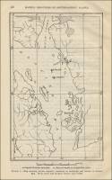
- Glacier Bay Mainland & Islands, Alaska – Marble & Limestone
Deposits (circa 1920) (Marble & Limestone) (Excerpt
from Mineral Resources of Southeastern Alaska, Bulletin
682, by Ernest F. Burchard, U. S. Geological Survey, 1920)
Mainland and Islands, Glacier Bay.
“Limestone and marble deposits crop out on the mainland on the east shore of Glacier Bay in the vicinity of sandy Cove. Along the north shore of Sandy Cove (No. 2) marble is exposed for 500 feet or more, and the deposit extends back into a low ridge 50 to 75 feet above the water. This marble is hard, of a light-grayish color, and generally of medium grain, but contains many small bodies of calcite of varying size. Nearly obliterated traces of fossil brachiopods were noted in it. The marble is brecciated in places and has been disturbed by the intrusion of dikes. Some of the brecciated portions contain magnesium carbonate. The beds here are 3 feet or more in thickness, strike northward and dip about 40° W. Where exposed the material is so much jointed and fractured that little stone of commercial size is obtainable.
“On the east shore of the cove next south of Sandy Cove (No. 3) are beds of variegated marble and partly metamorphosed limestone. The colors include gray with bluish veins, cream-colored with yellow veins, reddish, mottled chocolate-colored with yellow veins, reddish, mottled Chocolate-colored and pink, and mottled grayish-green and drab. The rock is fine grained, hard, and brittle and takes a good polish. It is generally much fractured at the surface, especially the gray limestone. Traces of Stylolites or suture joints were observed in the gray marble. The beds strike about S. 50° E. and dip steeply toward the northeast. This belt of rocks is about 500 feet thick and extends an indefinite distance southeastward into the mountains. The bedding is variable, but for the most part the rock is fairly massive. Dikes of diabase cut the beds in east and northeast directions, and the jointing runs generally in the same directions. The ridge which the marble forms is about 50 feet high at its northwest end, where a low cliff has been cut by the stream that flows into the cove, but toward the southeast the ridge rises to 500 feet or more in height within a quarter of a mile. (See fig. 1.)….” (above)
“Three claims, aggregating 3,960 feet in length, were at one time located on the strike of these beds, although little assessment work appeared to have been done up to the time of the writer’s visit. The really desirable and commercially valuable stone is probably scarce, and much prospecting will be necessary in order to establish its true extent and value.
“The bold cliffs on both sides of the entrance to the cove next south of Sandy Cove and also extending southward from it (No. 4) are composed principally of fine-grained hard, brittle, much fractured gray limestone, cut by many diabase dikes generally 2 to 10 feet thick. Along the contacts between the limestone and the larger dikes the limestone has been locally metamorphosed to white crystalline marble, but not much marble of this sort is available.
“In the float near the mouths of the two creeks that flow into this cove, which drain mountain glaciers, there are many boulders of good white and veined marble, and in the canyon of the northern of the two creeks, at about a mile from the mouth of the creek (No. 5), an outcrop of fine-grained grayish-green, partly metamorphosed limestone 10 to 12 feet thick was observed.
“Two islands in Glacier Bay, North Marble Island and South Marble Island, are composed wholly of marble, and others, such as Willoughby and Sturgess islands, show areas of limestone and marble. The two Marble islands lie about 12 ½ miles south of the entrance to Muir Inlet and are about 1 ½ miles apart. According to Coast and Geodetic Survey chart 8306 North marble Island (No. 6) is about half a mile in length from north to south and less than a third of a mile in greatest width. The highest point is probably about 300 feet above the sea. The marble exposed in this island is yellowish to grayish and is stained along fracture planes. The rock is medium in grain and on weathered surfaces is generally soft and friable. Some portions of the rock are cherty; other portions are brecciated. According to T. N. Dale the grain diameter ranges from 0.05 to 1.05 millimeters but is mostly from 0.25 to 0.75 millimeter. The estimated average is 0.216 millimeter. The Rosiwal measurement gives an average of 0.00977 (about 0.01 inch, or 0.248 millimeter). The Vermont grade is 5 (coarse) and the texture is even.
“Thin dikes of a dark fine-grained volcanic rock which appears to be altered spessartite cut the marble beds. The strike of the beds is nearly north. The rock has been jointed and in places shows small folds. The island has been glaciated, but weather has been active and has produced through solution of material along joint planes and rounding of intermediate portions a bouldery appearance over much of the rock surface. Most of the rock is bare, but in crevices there is a thin cover consisting of mossy soil and vegetation, and hollows where loose material can find lodgment contain small quantities of glacial clay, gravel, and boulders. The island is surrounded by fairly deep water, but the shores are abrupt and afford no harbor.”
-
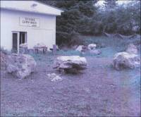
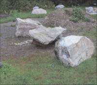
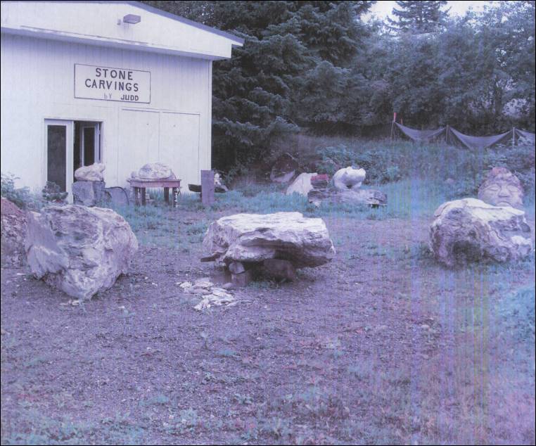
Haines (30 miles north of), Alaska – Serpentine Marble from the Mountains north of Haines, Alaska – The following photographs were contributed by Judd R. Mullady, Sculptor, Stone Carvings by Judd, Haines, Alaska.
- Ham Island, Alaska – the Miller Group of
Marble Quarries on Ham Island (circa 1907) (Marble) Excerpt
from “The Building Stones and Materials of Southeastern
Alaska,” by Charles W. Wright, in Mineral Resources
of Alaska: Report on Progress of Investigations in 1907,
Bulletin 345, by Alfred H. Brooks and Others, Department
of the Interior, United States Geological Survey, 1908,
pp. 122.
Ham Island.
“Ham Island lies at the junction of Blake Channel and Bradfield Canal, 25 miles southeast of Wrangell. It is about a mile and a half wide and consists largely of crystalline limestones with interstratified beds of calcareous schist striking N. 35° W. and dipping 75° NE. Intrusive dikes of basalt are common, and across the narrow channel on the mainland and on Wrangell Island wide belts of granite intrude these limestone and schist beds and have probably induced the present crystalline texture in the limestone and thus formed the marble.
“Two distinct varieties of marble are found – one fine grained and pure white, the other very coarse grained and pale blue. Several systems of jointing planes traverse the deposits, but the joints are widely separated and will not interfere greatly in quarrying. Checks or surface cracks are practically absent and wide areas of massive marble have been found directly underneath the soil. Much of the marble appears to be free from impurities.
“Two groups of claims have been located on this island, the Woodbridge-Lowery group on the west side and the Miller group on the east side. On the former the marble quarried is principally of a white, finely crystalline variety, but at the Miller property the deposit, exposed in a bluff 40 feet high and 100 feet long, is of a coarsely crystalline texture and a bluish color. On both of these properties considerable exploratory work has been done, and large blocks of the marble have been quarried, from which tombstones and small blocks have been chiseled and polished for local use. The properties are favorably located both for quarrying and transportation.”
- Ham Island, Alaska – the Miller Group of Marble
Quarries on Ham Island (circa 1907/1908) (Marble) Excerpt
from “Building Stones,” The Ketchikan and
Wrangell Mining Districts of Alaska, Bulletin 347,
by Fred Eugene Wright and Charles Will Wright, Department
of the Interior, United States Geological Survey, Washington:
Government Printing Office, 1908, pp. 198.
Ham Island.
“ Ham Island lies at the junction of Blake Channel and Bradfield Canal, 25 miles southeast of Wrangell (see Pl. III). It is about a mile and a half wide and consists largely of crystalline limestones with interstratified beds of calcareous schist striking N. 35° W. and dipping 75° NE. Intrusive dikes of basalt are common, and across the narrow channel on the mainland and on Wrangell island wide belts of granite intrude the limestone and schist beds and have probably induced the present crystalline texture in the limestone and thus formed the marble.
“Two distinct varieties of marble are found – one fine grained and pure white, the other very coarse grained and pale blue. Several systems of joint planes traverse the deposits, but the joints are widely separated and will not interfere greatly in quarrying. Checks or surface cracks are practically absent, and wide areas of massive marble have been found directly underneath the soil. Much of the marble appears to be free from impurities.
“Two groups of claims have been located on this island – the Woodbridge-Lowery group on the west side and the Miller group on the east side. On the former the marble quarried is principally of a white, finely crystalline variety, but at the Miller property the deposit, exposed in a bluff 40 feet high and 100 feet long, is of a coarsely crystalline texture and a bluish color. On both of these properties considerable exploratory work has been done, and large blocks of the marble have been quarried, and from these tombstones and small blocks have been chiseled and polished for local use. The properties are favorably located both for quarrying and transportation.”
- Ham Island, Alaska – Crystalline
Limestone on Ham Island (circa
1920) (Marble) (Excerpt from Mineral Resources
of Southeastern Alaska, Bulletin 682, by Ernest F. Burchard,
U. S. Geological Survey, 1920)
Blake or Ham Island.*
(* Footnote 1, page 93: Blake Island by decision of the United States Geographic Board; Ham Island on the Coast Survey chart and in local usage.)
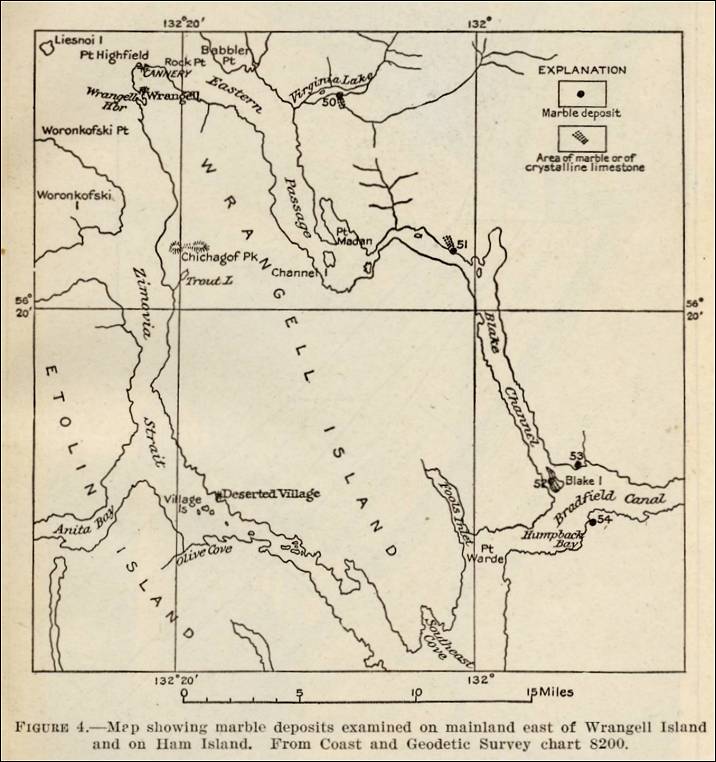
“Ham Island (see fig. 4) lies in Blake Channel at its junction with Bradfield Canal about 25 miles southeast of Wrangell (No. 52). It is about 1 ¼ miles long and is composed largely of crystalline limestone interstratified with beds of calcareous schist. These beds dip steeply northeast and strike about N. 35° W., falling in line with the long lens or belt of crystalline limestone that crops out on the mainland about 10 miles northwest of Ham Island.
Figure 4. Map showing marble deposits examined on mainland east of Wrangell Island and on Ham Island. From Coast and Geodetic Survey chart 8200. 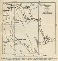
“The marble beds have been extensively tested on Ham Island, and deposits have been prospected also on the adjacent mainland east and southeast of the island, with the result that claims have been located in all these places. In the northern part of Ham Island the greater part of the marble available is coarse grained, and ranges in color from light grayish blue to dark gray; but some of it is nearly white. A little fine-grained marble, mostly white, occurs in the southeastern part of the island. The strata have been crumpled and folded and are slightly schistose in places, but the stone generally seems sound, and the rock is not so badly checked and fractured as in certain other marble areas in southeastern Alaska. Several systems of joint planes intersect the beds, but the joints are spaced widely enough not to interfere greatly with quarrying. The marble occurs in beds of varying thickness, generally 2 to 4 feet or more, that strike northward and dip at an angle of 50° or more toward the east. In the eastern part of the island, south of the middle, some beds of fine-grained white marble, 20 feet thick, alternating with coarser crystalline marble, have been revealed by the core drill. In some places the presence of many veins and nodules of quartz and chert in the white marble has been shown by drilling perpendicular to the bedding, and it is feared that they may present a serious obstacle to the utilization of these beds. The quartz veins are generally from a fraction of an inch to a few inches in thickness, though at least one vein a foot thick has been noted.
“Two groups of claims on Ham Island, owned originally by Woodbridge & Lowery and by Mr. Miller, have been purchased by the Vermont Marble Co. (see fig. 5) and are being thoroughly prospected by that company, but up to 1914 the results had not warranted opening a commercial quarry. Many large blocks of marble were quarried by the former owners, and from these blocks tombstones and small blocks have been cut and polished by hand for local use.
“Thin sections of two samples of marble from Ham Island were examined by T. N. Dale. One section of medium-grained grayish-blue marble showed in an irregular texture, with grains mostly elongate and much twinned. Graphite is present. Measurements by the micrometer showed a grain diameter ranging from 0.28 to 2.52 millimeters, mostly between 0.84 and 1.68 millimeters. The Rosiwal measurement showed an average diameter of 0.0127 inch, or 0.3235 millimeters, mostly between 0.84 and 1.68 millimeters. The Rosiwal measurement showed an average diameter of 0.0127 inch, or 0.3235 millimeter. The other section was taken from very coarsely crystalline grayish-white stone and showed a grain diameter ranging from 1.39 to 3.64 millimeters. The other coarse varieties fall between these two grades.”
- Ham Island near Wrangell, Alaska – the Ham Island
Marble Company (Marble) (The following information is
from “Marble Production in Individual States,” Mineral
Resources of the United States, 1905, David T. Day,
Chief of Division, Department of the Interior, United States Geological
Survey, Government Printing Office, Washington, D.C., 1906, pp.
1054.)
“Only a small quantity of Alaskan marble was put upon the market in 1905, and that was chiefly for the local monument trade….”
“The Ham Island Marble Company on Ham Island, near Wrangell, has operated on a small scale and put some marble on the market.”
-
Ham Island, Alaska – the Woodbridge-Lowery Group of Marble Quarries (circa 1907) (Marble) Excerpt from “The Building Stones and Materials of Southeastern Alaska,” by Charles W. Wright, in Mineral Resources of Alaska: Report on Progress of Investigations in 1907, Bulletin 345, by Alfred H. Brooks and Others, Department of the Interior, United States Geological Survey, 1908, 122.
Ham Island.
“Ham Island lies at the junction of Blake Channel and Bradfield Canal, 25 miles southeast of Wrangell. It is about a mile and a half wide and consists largely of crystalline limestones with interstratified beds of calcareous schist striking N. 35° W. and dipping 75° NE. Intrusive dikes of basalt are common, and across the narrow channel on the mainland and on Wrangell Island wide belts of granite intrude these limestone and schist beds and have probably induced the present crystalline texture in the limestone and thus formed the marble.
“Two distinct varieties of marble are found – one fine grained and pure white, the other very coarse grained and pale blue. Several systems of jointing planes traverse the deposits, but the joints are widely separated and will not interfere greatly in quarrying. Checks or surface cracks are practically absent and wide areas of massive marble have been found directly underneath the soil. Much of the marble appears to be free from impurities.
“Two groups of claims have been located on this island, the Woodbridge-Lowery group on the west side and the Miller group on the east side. On the former the marble quarried is principally of a white, finely crystalline variety, but at the Miller property the deposit, exposed in a bluff 40 feet high and 100 feet long, is of a coarsely crystalline texture and a bluish color. On both of these properties considerable exploratory work has been done, and large blocks of the marble have been quarried, from which tombstones and small blocks have been chiseled and polished for local use. The properties are favorably located both for quarrying and transportation.”
- Ham Island, Alaska – the Woodbridge-Lowery
Group of Marble Quarries on Ham Island (circa 1907/1908)
(Marble) Excerpt
from “Building Stones,” The Ketchikan
and Wrangell Mining Districts of Alaska, Bulletin 347,
by Fred Eugene Wright and Charles Will Wright, Department
of the Interior, United States Geological Survey, Washington:
Government Printing Office, 1908, pp. 198.
Ham Island.
“ Ham Island lies at the junction of Blake Channel and Bradfield Canal, 25 miles southeast of Wrangell (see Pl. III). It is about a mile and a half wide and consists largely of crystalline limestones with interstratified beds of calcareous schist striking N. 35° W. and dipping 75° NE. Intrusive dikes of basalt are common, and across the narrow channel on the mainland and on Wrangell island wide belts of granite intrude the limestone and schist beds and have probably induced the present crystalline texture in the limestone and thus formed the marble.
“Two distinct varieties of marble are found – one fine grained and pure white, the other very coarse grained and pale blue. Several systems of joint planes traverse the deposits, but the joints are widely separated and will not interfere greatly in quarrying. Checks or surface cracks are practically absent, and wide areas of massive marble have been found directly underneath the soil. Much of the marble appears to be free from impurities.
“Two groups of claims have been located on this island – the Woodbridge-Lowery group on the west side and the Miller group on the east side. On the former the marble quarried is principally of a white, finely crystalline variety, but at the Miller property the deposit, exposed in a bluff 40 feet high and 100 feet long, is of a coarsely crystalline texture and a bluish color. On both of these properties considerable exploratory work has been done, and large blocks of the marble have been quarried, and from these tombstones and small blocks have been chiseled and polished for local use. The properties are favorably located both for quarrying and transportation.”
- Ham Island, Alaska – the Marble Quarrying on Ham
Island in the Wrangell Mining District (circa 1908) (Marble) Excerpt
from “Building Stones and Materials,” Mineral
Resources of Alaska: Report on Progress of Investigations
in 1908, Bulletin 379, By Alfred H. Brooks and Others,
Department of the Interior, United States Geological Survey,
1909, 84-85.
“The Ham Island marble properties, in the Wrangell mining district, were bonded early in September, and a crew of men was employed to determine the extent of the deposits on this island. The work consisted of surface excavations and diamond-drill explorations. Except small blocks for local use, there was no production from this locality.”
- Ham Island, Alaska – the Miller Group of Marble
Quarries on Ham Island (circa 1907/1908) (Marble) Excerpt
from “Building Stones,” The Ketchikan and
Wrangell Mining Districts of Alaska, Bulletin 347,
by Fred Eugene Wright and Charles Will Wright, Department
of the Interior, United States Geological Survey, Washington:
Government Printing Office, 1908, pp. 198.
-
Heceta Island, Alaska – Map showing
marble deposits examined on northern Prince of Wales Island
and on Kociusko, Marble, Orr, and Heceta islands (circa
1920) (Marble) (Excerpt from Mineral Resources
of Southeastern Alaska, Bulletin 682, by Ernest F. Burchard,
U. S. Geological Survey, 1920)
(Map caption) Plate III. Map showing marble deposits examined on northern Prince of Wales Island and on Kociusko, Marble, Orr, and Heceta islands (Alaska). From Coast and Geodetic Survey charts Nos. 8200 and 8150. (pp. 28) 
- Heceta Island, Alaska – Marble
Deposits on Heceta Island (circa
1920) (Marble) (Excerpt from Mineral Resources
of Southeastern Alaska, Bulletin 682, by Ernest F. Burchard,
U. S. Geological Survey, 1920)
Heceta Island
“In order to verify several reported occurrences of marble on Heceta, Tuxekan, and smaller neighboring islands practically all the remaining shores of Sea Otter Sound and Davidson Inlet, as well as parts of Tuxekan Passage and Tonowek Bay, were examined. The calcareous rocks bordering these shores proved to be for the most part nonmetamorphosed limestone, principally of the gray or blue fine-grained brittle type, with fractures filled with calcite. Near the middle of the north side of Heceta Island (No. 36) is an exceptional limestone colored pink, red, chocolate, green, yellow, and white, with mottled effects. The stone is fine grained, hard, and dense and takes an excellent polish. (See Pl. XVII.) Some of it is conglomeratic. It has been somewhat fractured and recemented with calcite, but it is only slightly metamorphosed, and it yielded a few fossils, among which were recognized Conchidium sp., Capellinia sp., Trochonema sp., Heliolites sp., and a pentameroid (?). These forms, according to Edwin Kirk, are of late Silurian age. This limestone crops out at the head of a small bay and was traced southeastward on the strike for about 300 yards and to an altitude of 50 feet or more above high tide. In places the colors are much paler, but the mottled character persists, and much of the stone is attractively colored. An area of graywacke borders this limestone on the west and north. The rock is covered in most places by only a moderate thickness of moss and soil and supports the usual growth of brush and timber. Claims located on this mottled limestone by W. C. Waters are reported to have been sold to the Vermont Marble Co. in 1914. No marble was found on the smaller islands within this area – Cap, Hoot, Owl, Eagle, White Cliff, and Green islands.
Analysis of mottled limestone from Heceta Island.
Insoluble matter – 13.18
Calcium carbonate (CaCO3) – 84.46
Magnesium carbonate (MgCO3) – 2.85
“Samples of marble obtained near Waterfall Bay (No. 37), on the west coast of Dall Island, were shown to the writer at Ketchikan by M. D. Ickis in 1912 and found to be of much merit. The principal colors are white, pink, gray, and blue-black. The white and pink varieties are very handsome, the pink occurring in various delicate shades and in areas mottled with white. Some of the white marble is veined with yellow. Green marble is reported to occur but has not been much prospected. The white and pink varieties appear to have been wholly metamorphosed, but the gray and blue varieties appear to possess the characteristics of little-altered limestone. The grain of all the samples is fine, that of the gray and blue varieties exceedingly fine. In the lighter-colored varieties calcite crystals larger than the average are exceptionally present, but in general the texture is uniform, and thin pieces of the stone are as translucent as alabaster. This marble takes a very high polish. (See Pls. XVIII and XIX, A.)”
Plate XVII. A. Finely mottled limestone from northern part of Heceta Island. 
Plate XVII. B. Coarsely mottle limestone from northern part of Heceta Island. 
-
Hope, Alaska – Hope Stone LLC Slate Quarry (Slate) (present-day company)
- About Us (Hope Stone, LLC, Slate Quarry): (The following excerpt if from the web site.)
“Hope Stone LLC is a small father and son owned and operated slate stone quarry in Hope, Alaska. It was founded by Henry Drechnowicz who was hunting in the mountains of Hope when he stumbled across a large, fine quality deposit of ancient seabed slate stone. When he saw the quality of his discovery he also saw the potential market for this beautiful stone….”
- About Us (Hope Stone, LLC, Slate Quarry): (The following excerpt if from the web site.)
On a yearly basis, Browns Hill Quarry processes and manufactures 200,000 cubic yards of materials. The quarry is the only commercial basalt source in Interior Alaska. Basalt is an igneous rock formed from hot magma that extrudes onto the surface….”


- Juneau, Limestone
Inlet, Alaska – Marble
Deposits (circa 1920) (Marble) (Excerpt from Mineral
Resources of Southeastern Alaska, Bulletin 682, by
Ernest F. Burchard, U. S. Geological Survey, 1920)
Important Undeveloped Deposits.
- Kachemak Bay State Park & State Wilderness Park – Limestone
Quarry
- Grace Ridge Trail (Listed in the Trails in Kachemak Bay State Park section of the web site.) It is mentioned that the Kayak Beach Campsite was once an area that was used as a rock quarry, although the type of quarry and stone is not indicated.
- Seldovia Otterbahn Trail (listed on the Home, Alaska, Visitor’s Guide web site, presented by the Homer Tribune. One of the points of interest on this hike is a limestone quarry.
- Ketchikan, Alaska – Ketchikan District Marble Quarries
History & Photographs (The following photograph
can be found in SitNews:
Stories in the News, “Mining,
Once Ketchikan’s Principal Industry,” by David
Kiffer, July 28, 2006. (This article includes a section on the
marble quarries in the Ketchikan area of southeastern Alaska.)
Stone quarry photo captions included in article:
“S.S. Diamond Cement loading limestone at View Cove, 1938”
“Dock and quarry at View Cove”
-
Kociusko Island, Alaska – Map showing marble deposits examined on northern Prince of Wales Island and on Kociusko, Marble, Orr, and Heceta islands (circa 1920) (Marble) (Excerpt from Mineral Resources of Southeastern Alaska, Bulletin 682, by Ernest F. Burchard, U. S. Geological Survey, 1920)
(Map caption) Plate III. Map showing marble deposits examined on northern Prince of Wales Island and on Kociusko, Marble, Orr, and Heceta islands ( Alaska ). From Coast and Geodetic Survey charts Nos. 8200 and 8150. (pp. 28) - Kosciusko Island, Alaska – Marble & Limestone
Exposures (circa 1920) (Marble & Limestone) (Excerpt
from Mineral Resources of Southeastern Alaska, Bulletin
682, by Ernest F. Burchard, U. S. Geological Survey, 1920)
Kosciusko Island.
“On Kosciusko Island, on the opposite side of the channel from the El Capitan marble claims, are exposures of marble (No. 30), most of which is grayish, although some is nearly white. This marble is rather fine grained and is cut by fractures filled by siliceous seams like those on the El Capitan property. These seams are one-sixteenth to one-fourth inch thick, are spaced from 4 inches to 4 feet apart, strike N. 50° E., and are nearly vertical. According to practical marble men the presence of quartz seams in such abundance as these renders the marble of very doubtful commercial value. Toward the east and south along this shore of Kosciusko Island the marble gradually merges into less metamorphosed limestone. At Aneskett Point the rock is a dense fine-grained limestone, much fractured and seamed with calcite.
“In the eastern part of Kosciusko Island, between the southwest base of Pyramid Peak and the head of Tokeen Bay, three claims of 160 acres each (No. 31) have been located by the Vermont Marble Co. The marble here lies south of the granitic mass that is believed to have produced the metamorphism of the marble deposits of Calder and the El Capitan claim farther north. The deposit is exposed for about 200 feet in a steeply sloping bluff 20 to 30 feet high on the left bank of a small mountain creek that flows southwestward into Tokeen Bay about half a mile distant. At the lower end of the exposure the marble is dark bluish gray and fine grained, but the greater part of the deposit is medium grained and white and is thinly veined with dark-gray or yellowish seams. On the exposed face the marble is very soft and crumbly, almost saccharoidal, and it was difficult to obtain a sample firm enough to be carried away. The beds are cut by numerous joint planes. Prospecting has been done by blasting and by core drilling nearly at right angles to the face, which seems to represent a steep dip slope. The prospects are about 200 feet above sea level. To transport the marble to tidewater it would be necessary to build one-half to three-fourths of a mile of tramway through some rather rough country.
“On the southeast shore of Kosciusko Island northeast of Edna Bay outcrops of dull to dark gray limestone alternate with narrow areas of graywacke for 2 miles or more. The limestone is cut by basaltic dikes and is everywhere badly cracked. At the contact with some dikes it is locally metamorphosed to marble, but the marble thus produced is probably not of uniform quality nor of sufficient extent to be of commercial value. On the shore 3 or 4 miles north east of Edna Bay a small area of fine-grained red and white mottled limestone was noted, and a short distance inland, along a small stream (No. 32), occurs an area of fine-grained variegated marble in which stone of yellow, sienna, and red shades predominates. This is the same bed as the variegated limestone on the north side of Heceta Island (p. 76). Claims have been located in this area by W. C. Waters, of Wrangell, Alaska, and have been extensively prospected by the Vermont Marble Co.
“A sample of brecciated fine-grained green limestone, seamed by veins of pink calcite, was sent to the Survey by W. C. Waters in the winter of 1915 from Kosciusko Island, ‘7 miles from Holbrook,’ probably in a southwest direction, which places it near locality 32. The green limestone is more or less mottled by dark and light green fragments, which, together with the pink veins, would probably produce a handsome effect in a polished surface. The rock shows slickensides, is very brittle, and breaks rather easily; therefore it might be difficult to work into large slabs. Mr. Waters states that the rock strikes northwest and extends over an area 100 by 300 feet; that the covering is moss, timber, and brush; and that the formations with which the green rock is associated are limestone and conglomerate.
“Another interesting sample sent by Mr. Waters is a conglomerate of fine-grained light-gray limestone pebbles in a pink calcareous matrix cut by thin veins of yellowish calcite filling fault fissures. This rock is a little harder than the breccia described above and would undoubtedly polish well and produce a handsome effect. It is not known whether large blocks are available. The locality is given as Kosciusko Island, ‘6 miles from Holbrook,’ the observed extent of the material is 400 feet by a quarter of a mile, and the cover as moss, brush, and timber. The associated formation is reported to be limestone striking northwest.”
- Kosciusko Island, Alaska – “Kosciusko Island, Alaska. Marble prospect near southwest base of Pyramid Peak. Circa 1912.” (Photograph from the United State Geological Survey Photographic Library.)
- Kodiak Island, Alaska – Shakmanoff Quarry (Granitic Rock) (proposed present-day quarry), presented by Alaska Earth Sciences.
- Kodiak, Alaska – Stone Quarry on Fort Greely, DEC and Searchlight Bunkers, Kodiak Alaska. On the "Kodiak Alaska Military History/Gibson Cove and Deadman’s Curve" section of Joe Stevens’ Cursty Old Joe’s Place Kodiak Alaska Military History web site, there is mention of a stone quarry and includes a photograph.
“Some of the undeveloped deposits of marble described in this paper (those from which no stone has been quarried) possess elements of possible economic value, but not all of them seem to warrant prospecting, and even those that have appeared most favorable on cursory inspection may prove on prospecting to be totally unfit for exploitation. The more important of these undeveloped deposits, whose surface appearance and general relations suggest that further investigations might be warranted whenever the demand for marble on the Pacific coast exceeds the present production, are mentioned in the following summary…:
“Limestone Inlet opens directly on one of the highways of travel, Stephens Passage, and is close to a base of supplies at Juneau; therefore, although the surface appearance of the grayish-white and banded medium-grained marble 1 mile above the head of this inlet (No. 1) does not suggest that stone of the highest quality is present here, the hope of finding a good marble deposit in this advantageous location should encourage more thorough prospecting.”
“The white and gray fine-grained banded marble in the vicinity of Basket Bay and the neighboring cove to the south, on the Chatham Strait shore of Chichagof Island (Nos. 11, 12, 13), seems promising. There appears to be a very large body of marble in this vicinity, and the larger of the deposit the better should be the chances of finding a portion of it workable.
“The exposed portion of the deposit of white to white and gray hard medium-grained marble a third of a mile south of Marble Cove, on the Chatham Strait shore of Admiralty Island (No. 17), has a terrace form that suggests a favorable site for a quarry. There is an abundance of timber and fresh water here, and although the harbor near by is small, breakwaters and docks could be constructed that would afford protection and facilities for loading vessels.”
According to the Alaska Earth Sciences web site, they consulted for the “Koniag Native Corporation for its proposed Shakmanof quarry since 2009… The quarry would make use of granitic rock for construction material.”
-
Kosciusko Island, Alaska – Marble Deposits on Kosciusko Island (circa 1920) (Marble) (Excerpt from Mineral Resources of Southeastern Alaska, Bulletin 682, by Ernest F. Burchard, U. S. Geological Survey, 1920)
Important Undeveloped Deposits.
“Some of the undeveloped deposits of marble described in this paper (those from which no stone has been quarried) possess elements of possible economic value, but not all of them seem to warrant prospecting, and even those that have appeared most favorable on cursory inspection may prove on prospecting to be totally unfit for exploitation. The more important of these undeveloped deposits, whose surface appearance and general relations suggest that further investigations might be warranted whenever the demand for marble on the Pacific coast exceeds the present production, are mentioned in the following summary….:
“Kosciusko Island, in the vicinity of Edna Bay (No. 32), contains areas of fine-grained, partly metamorphosed limestone of variegated shades and mottled effects, susceptible of high polish, and similar material occurs on the north side of Heceta Island (No. 36).”
- Koscuisko Island, Aneskett, Alaska - Limestone Quarries (From
Southeastern Coastal Alaska Limestone Terrain (1944), presented
by the Alaska Department of Natural Resources. The information
in the report was taken from a report "Limestones of the Pacific
Northwest," by Edwin Hodge, industrial raw materials consultant,
September 1, 1944, for the Bonneville Power Administration.) (The
link from which this information was obtained is no longer available.)
<http://wwwdggs.dnr.state.ak.us/scan1/mr/text/MR191-08.PDF>"Aneskett, easternmost point, 56° 9’ N.; 133° 16’ W.
"Rocks: Silurian limestone covers most of the Island; jointed and sheared; cut by dikes which have produced marbleizing effects.
"Quality: Gradually changes to marble from Neskett westward; limestone acnsc (sic), massive, nodular and shaly; 95-99% CaCO3; some contact metamorphic minerals.
"Commercial Considerations: Large, thick, Quarries. Port of occasional call by steamers."
-
Kurpreanof Island, Alaska – Limestone & Marble Deposits on Kurpreanof Island (circa 1920) (Marble) (Excerpt from Mineral Resources of Southeastern Alaska, Bulletin 682, by Ernest F. Burchard, U. S. Geological Survey, 1920)
Kupreanof Island.
“Beds of limestone interstratified with schist have been noted on Kupreanof Island on the west side of Duncan Canal. Among the Castle Islands beds or lenses or cherty limestone containing veins of calcite were noted by the writer to be nearly in strike with a lens of barite,* with relations suggesting that the barite may have been formed through the replacement of limestone. In the autumn of 1914 W. C. Waters forwarded to the Survey samples of partly metamorphosed light and dark grayish-blue limestone with bands and patches of white calcite from the north side of the west arm of Duncan Canal and light-gray finely laminated marble from the south side of the west arm of Duncan Canal. Although he charts of the Coast and Geodetic Survey do not show which is the ‘west arm’ of Duncan Canal, it is believed that this arm is the shallow one that joins the main body of water about 4 miles south of the Castle Islands, and it is therefore indicated as locality 19 on the accompanying index map (Pl. I). The grain of the samples from the north side of the arm is irregular, ranging from moderately fine in the mass to moderately coarse in the calcite streaks. The light grayish-blue sample from the south shore is medium and more even grained but shows numerous coarser calcite crystals and a few specks of pyrite. According to Mr. Waters these deposits are exposed along the beach for about 1 ½ miles and lie about 2 miles from deep water. The rock strikes northwest and dips about 45° SW. The associated beds are shale and schist, and the overburden consists of 6 to 8 feet of moss and soil. The limestone and marble are themselves schistose, and the samples submitted appear to be of no particular merit, but the occurrence is noted here in the hope that it may lead to further and better discoveries in this locality, which is centrally situated and near steamship routes.
(* Footnote 1, page 56: Burchard, E. F., A barite deposit near Wrangell, Alaska : U. S. Geol. Survey Bull. 592, pp. 109-117, 1914 (Bull. 592-D).) ”
-
Limestone Inlet on the mainland, Alaska – Marble Deposits (circa 1920) (Marble) (Excerpt from Mineral Resources of Southeastern Alaska, Bulletin 682, by Ernest F. Burchard, U. S. Geological Survey, 1920)
“The deposits of marble in the vicinity of Limestone Inlet are on the mainland about 25 miles south-southeast of Juneau and 2 ½ miles inland from the mouth of the inlet, or 1 to 1 ½ miles from deep water (No. 1). Outcrops on the north bank of Limestone creek consist of medium-grained grayish-white marble, banded in places with dark-gray streaks and veins of white calcite of coarser texture. Portions of the beds have a grayish-green color, possibly due to surface stains. Some parts of the mass are schistose and carry hornblende, mica, pyrite, and thin seams of quartz. The gray and green varieties are both susceptible of a fair polish. The surface of the marble is cut by two or more sets of joints into blocks from a few inches to 3 feet thick. The strike of the rocks is apparently between N. 25° W. and N. 30° W., and the dip is steep toward the northeast.
“Two samples of marble from Limestone Inlet was examined microscopically by T. N. Dale. A specimen of the grayish-white variety showed a grain diameter of 0.037 to 1.28 millimeters, mostly 0.185 to 0.74 millimeter, with an estimated average of 0.277 millimeter. By use of the Rosiwal method the average diameter of the grains was found to be 0.0103 inch, or 0.262 millimeter. The grade is therefore medium; but, compared with Vermont marbles, according to Dale’s classification, this marble would fall into grade 5 (coarse). The texture is uneven, and some pyrite was noted.
“A specimen of the greenish variety showed a grain diameter of 0.074 to 0.925 millimeter, mostly 0.185 to 0.555 millimeter, with an estimated average of 0.216 millimeter. The Rosiwal measurement gave an average of 0.007 inch, or 0.1778 millimeter, thus indicating a medium texture. The grain form appears a little uneven. Very little pyrite is present in the section, and quartz is rare, in minute particles.
“Associated with the schistose marble are beds of hornblende mica schist. A thin section examined by J. B. Mertie showed quartz, sericite, hornblende, chlorite, epidote (derived in large part from hornblende), and sulphides.
“Two groups of marble claims have been located on this deposit, and two small prospect openings about 200 feet apart have been made near the creek bank. Between these two openings several natural exposures in the bank of the creek indicate the presence of schistose marble.
“Most of the marble deposit is covered by forest growth, and little could be ascertained as to its extent or structure beyond the indications afforded by the few exposures. In order to develop this deposit a tramway must be built from the property down the creek to deep water in Limestone Inlet, a distance of about 1 ½ miles. The construction of the tramway would involve the cutting away of some rocky points and the building of half a mile or more of trestle.”
- Long Island, Ketchikan District, Alaska – Marble
Deposit on Long Island (circa 1916) (Marble) (Excerpt
from “The Marbles of Alaska” in Stone: An Illustrated Magazine, Vol. XXXVII, No. 11, November 1916, pp. 583-584.)
“Interests in the development of marble properties continues, especially in the Ketchikan district….”
“Deposits of marble have recently been located near the northwest end of Long Island, 3 to 4 miles north of Howkan, on two small bays known locally as Waters and Gotsongni bays At this locality the brush is very thick along the shore and outcrops are few, making prospecting difficult, but the physical conditions favor the exploitation of the deposits. The shore of the island rises abruptly from the beach, the timber is plentiful and of an exceptionally good grade, and the deposits occur on sheltered harbors which afford easy access to boats.”
“On Gotsongni Bay marble occurs on the east shore, three-quarters a mile from the head. On the beach are outcrops of coarse-grained, even-textured white marble. A short distance back from the beach and separated from the white marble by a brush-concealed area is a large body of bluish-white marble with black stripes. The rock is medium grained and even textured. It takes a good polish and is apparently free from quartz.”
- Long Island, Alaska -
Map showing marble deposits examined on Dall and Long islands
(Marble) (Excerpt from Mineral Resources of Southeastern
Alaska, Bulletin 682, by Ernest F. Burchard, U. S. Geological
Survey, 1920)
(Map caption) Plate IV. Map showing marble deposits examined on Dall and Long islands (Alaska). From Coast and Geodetic Survey chart No. 8150. (pp. 30) 
- Long Island, Alaska – Marble
Deposits on Long Island (circa
1920) (Marble) (Excerpt from Mineral Resources
of Southeastern Alaska, Bulletin 682, by Ernest F. Burchard,
U. S. Geological Survey, 1920)
Long Island.
“The northern part of Long Island appears to contain promising areas of marble. This part of the island is largely surfaced by calcareous rock. Theodore Chapin, who visited this locality in the summer of 1915, reports as follows:
“‘Deposits of marble have recently been located near the northwest end of Long Island, 3 to 4 miles north of Howkan, on two small bays known locally as Waters and Gotsongni bays. At this locality the brush is very thick along the shore and outcrops are few, making prospecting difficult, but physical conditions favor the exploitation of the deposits. The shore of the island rises abruptly from he beach, the timber is plentiful and of an exceptionally good grade, and the deposits occur on sheltered harbors which afford easy access to boats.
“On Waters Bay three claims, the Lily, Long Island, and White Cloud, have been located, and assessment work has been done. Most of the marble exposed has a bluish-white field with white-mottled areas and blue-black stripes. Under the microscope the rock is seen to be composed essentially of twinned calcite crystals ranging in size from 0.25 to 0.7 millimeter, inclosed in a network of finely granular calcite that averages about 0.05 millimeter and forms with the large calcite crystals an intersertal (sic) fabric. The large calcite crystals are bent and fractured. They are evidently crushed fragments around which the fine-grained calcite has recrystallized. The black stripes are composed of opaque particles of carbonaceous material, probably graphite. Associated with the striped marble are beds of medium-grained white marble of even texture and also beds of blue-clouded white marble with yellow patches. This rock takes an excellent polish.’
“The deposit at the head of Waters Bay (No. 45) is reported by Mr. Waters to strike northwest and to extend up both sides of a small stream for a distance of a mile, with a width of 2,000 feet. Samples of white, pearl-gray, gray-banded, and gray-veined marble from this locality were received at the office of the Geological Survey. The white marble is medium grained and shows faint pinkish-yellow tints. The hand sample is of granular texture, shows a bright, sparkling surface, and is translucent on thin edges. When struck it gives a clear ring.
“A thin section of the pearl-gray marble was examined by G. F. Loughlin. The material as seen under the microscope appears to be rather even-grained calcite, mostly twinned, with fine granulated borders. The grain diameters range from 0.08 to 0.7 millimeter and average between 0.20 and 0.25 millimeter, as the coarser grains predominate. The grade is, in general, medium. A few very fine oxidized pyrite grains scattered through the section were noted. The largest of these is only 0.04 or 0.05 millimeter in diameter. The section shows several minute limonite pseudomorphs after pyrite, also a few streaks of limonite, sufficient to give a pale-brown streak across a hand sample of the marble. A shear zone, containing rounded grains and a few very fine grains of quartz in a matrix of pulverized calcite, was noted. No quartz was seen elsewhere in the section. So far as the material in the thin section is concerned, oxidation is practically completed and no further staining from pyrite is likely. In fact, pyrite is so rare in the sample as to cause a negligible amount of staining.
“The banded marble is similar in texture to the white marble but has a light-gray body with the parallel straight thin bands of darker gray spaced one-eighth to one-half inch apart. The veined marble is similarly colored by less uniformly grained. The veins and clouded areas show attractive patterns produced by folding of the rock. It is reported that this deposit appears to be ‘solid’ – that is, comparatively free from fractures and joints.
“According to Messrs. Chapin and Waters there is at the northwest corner of Long Island, on the east side of Gotsongni Bay about three-quarters of a mile from the head of the bay (No. 46), an exposure of marble half a mile in length. The beds appear to strike north-northwest, or parallel with the axis of the bay. On the beach are outcrops of coarse-grained even-textured white marble by a brush-concealed strip in a large area of bluish-white to bluish-gray marble with black stripes. The rock is medium grained and even textured. It takes a good polish and is apparently free from quartz. White and pink varieties of marble are also reported to occur in this locality.
“A sample of the white marble sent to Washington by Mr. Waters is medium-grained calcitic material with a bright, sparkling surface where freshly broken. The rock possesses a high degree of translucence. A thin section of this marble was examined under the microscope by G. J. Loughlin. The material is composed of large irregular grains separated by a network of fine grains. This texture is due to granulation along the boundaries of the crystals and has been termed ‘flaser’ structure. (See p. 79.) The diameter of the interstitial grains is 0.02 to 0.10 millimeter with an average of about 0.04 millimeter. The coarser grains are 0.02. to 2.6 millimeters across and average about 0.06 millimeter. The average grain diameter of the marble, according to Mr. Chapin, is 0.25 millimeter. The only impurities noted by Mr. Loughlin were a cluster of pyrite (?) grains about 0.14 millimeter across and one very minute crystal of quartz (?).
“A sample of the pink marble consists of medium to coarse grained crystalline calcite, of a salmon-pink shade. The rock takes a good polish, and the polished surface brings out slight variations in the pink color and also several streaks of colorless calcite.”
- Long Island, Alaska – Marble
Deposits on Long Island (circa
1920) (Marble) (Excerpt from Mineral Resources
of Southeastern Alaska, Bulletin 682, by Ernest F. Burchard,
U. S. Geological Survey, 1920)
Important Undeveloped Deposits.
“Some of the undeveloped deposits of marble described in this paper (those from which no stone has been quarried) possess elements of possible economic value, but not all of them seem to warrant prospecting, and even those that have appeared most favorable on cursory inspection may prove on prospecting to be totally unfit for exploitation. The more important of these undeveloped deposits, whose surface appearance and general relations suggest that further investigations might be warranted whenever the demand for marble on the Pacific coast exceeds the present production, are mentioned in the following summary….:
“The northern part of Long Island appears to contain promising deposits of marble. On Waters Bay (No. 45) occur attractive white, bluish-white, pearl-gray, gray-veined, and banded marbles, generally of medium grain, and on Gotsongni Bay (No. 46) there are deposits of medium-grained white, pink and white, and bluish-white and gray marble of good quality. Both of these areas are said to be located favorably for quarrying and shipping.”
- Lynn Canal (in), Alaska – White Marble Depositcirca 1897 (The following information is from Alaska and Its Resources, by William H. Dall, Boston: Lee and Shepard Publishers, 1897, pp. 476.)
“The beds of white marble near Sitka and in Lynn Canal, if uniformly of as good quality as the specimens obtained by the United States Coast Survey officers, will prove of great value. The natives have long been in the habit of carving images, labrets, &c., of this material.”
- Mainland East of Wrangell Island,
Alaska – Crystalline Limestone on
the Mainland East of Wrangell Island (circa 1920) (Marble) (Excerpt
from Mineral Resources of Southeastern Alaska, Bulletin
682, by Ernest F. Burchard, U. S. Geological Survey, 1920)
Mainland East of Wrangell Island.
“A long, narrow belt of crystalline limestone, containing true marble in many places, extends in a northwesterly direction on the mainland for a distance of about 17 miles, beginning at Blake Channel and lying nearly parallel to Eastern Passage.* Blake Channel itself follows the strike of this belt and may represent a drowned valley developed along these comparatively soluble rocks. At the south end of Blake Channel certain small areas of marble, including Ham Island and areas on the north and south sides of Bradfield Canal, are also practically in strike with this belt. The metamorphism of this limestone to marble has probably been caused by the intrusion of wider belts of granite to the east on the mainland and to the west on Wrangell Island. Metamorphic minerals such as talc are present in the marble deposit near the east end of Lake Virginia, described below.
(* Footnote 1, page 90: U. S. Geol. Survey Bull. 347, pl. 3, 1908.)
“ Lake Virginia. – The upper end of Lake Virginia (formerly known as Mill Lake), distant about 4 miles from Eastern Passage and about 12 miles from Wrangell, cuts through this belt of marble (No. 50). The rock ranges from grayish-white and coarse-grained marble at the east side of the exposure to fine-grained bluish-gray and veined marble at the west. The fine-grained grayish and banded material predominates. Near the east side, near the contact with granitic intrusive rock, contact minerals of fibrous radial character are developed in the coarse-grained marble.
“Three thin sections of marble from this locality were examined by T. N. Dale and G. F. Loughlin.
“A section of the grayish-white marble showed a very uneven texture, being composed mainly of portions having two grades of fineness. Micrometer measurements of the grain diameter of the finer part showed a range from 0.074 to 0.555 millimeter, with an estimated average of 0.154 millimeter. The coarser part showed a grain diameter from 0.185 to 2 millimeters, mostly 0.37 to 1.1 millimeters, with an estimated average of 0.434 millimeter. A few grains of quartz are present.
“A section of the gray marble showed an even texture and a grain diameter ranging from 0.05 to 0.62 millimeter, mostly between 0.125 and 0.375 millimeter, with an estimated average of 0.145 millimeter. According to the Rosiwal measurement the average grain diameter is 0.0054 inch, or 0.137 millimeter.
“A section of the coarse-grained, nearly white marble containing a fibrous mineral in large radial aggregates consists largely of talc bands or fibers in extremely thin parallel and divergent aggregates 0.01 to 0.1 millimeter thick, between broader bands of calcite. Considerable carbonate is interleaved with the talc fibers. Here and there large plates of dolomite cross the foliation. Many minute crystals of pyrite rusting to limonite are present. It is suggested by Mr. Loughlin that the talc may have been derived through the complete replacement of tremolite or diopside, or that it may be a primary metamorphic mineral formed under less heat and pressure than required to form tremolite and diopside. Local conditions favor the possibility that the talc is a primary metamorphic mineral.
“The chief constituents of this rock as determined by. R. K. Bailey are as follows:
Analysis of talcose marble from deposit near Lake Virginia.
Insoluble matter – 19.06
Calcium carbonate (CaCO3) – 53.69
Megnesium (sic) carbonate (MgCO3) – 26.10
“This marble belt is exposed at short intervals along the south shore of Lake Virginia for a distance of about 1,000 feet and was traced toward the southeast for more than half a mile. The beds range from thin and schistose to massive. They dip steeply toward the northeast and strike N. 15° - 25° W. On the southwest the belt is bordered by schist; on the northeast, although no direct contact is visible, boulders of granite indicate the character of the adjacent rock.
“Several marble claims have been staked on the outcrops along the shore of Lake Virginia, though there was but little evidence of assessment work or prospecting when the locality was visited by the Survey party in September, 1913. At one point a short tunnel had been driven in pyritiferous schistose beds in search of metalliferous ore. Until considerable prospecting with a core drill is done, nothing definite can be known as to the probable value of this marble deposit. Back from the lake shore the surface is rough and covered generally with a heavy growth of timber and moss, with the usual soil, muck, and underbrush in the low places. If marble of value should be found, quarries could be opened near the lake shore, and blocks could be transported on tram cars carried on a barge to the foot of Lake Virginia, a distance of about 2 miles, beyond which a tramway 1 ½ miles long would have to be built down Mill creek to deep water in Eastern Passage. The level of the lake is probably about 200 feet above the sea, and there is a large overflow from the lake, considerable water power might be developed here. In fact, it is said that a small fall near the shore of Eastern Passage was once so utilized.
“Blake Channel. – On Blake Channel 8 or 9 miles southeast of Lake Virginia this belt of marble crops out on tidewater (No. 51). Here the marble is medium grained to coarse grained, mostly bluish in color, and generally banded with gray. In places the color is light blue to white. A thin section of the gray and blue banded material examined by T. N. Dale showed an even texture, crossed by parallel graphitic (?) streaks with some pyrite. The calcite shows much close twinning. The grain diameter ranges from 0.11 o 1.1 millimeters, mostly between 0.185 and 0.74 millimeter, with an estimated average of 0.275 millimeter. The beds stand nearly vertical and strike about N. 10° W. The marble is exposed for 200 or 300 yards along the shore, and extends an undetermined distance into the mountains toward the north-northwest. On the west the bordering rock is schist, and on the east the marble is in contact with an intrusive mass of quartz-bearing basalt. A mass of fine-grained gray granite forms a cliff on Blake Channel about 3 miles west-northwest of this locality. Five claims of 20 acres each have been staked on this marble by Frank Spalding, of Wrangell, who has opened several prospects.”
- Mainland east of Wrangell Island, Alaska – Marble
Deposits on the mainland east of Wrangell Island
(circa 1920) (Marble) (Excerpt from Mineral Resources
of Southeastern Alaska, Bulletin 682, by Ernest F. Burchard,
U. S. Geological Survey, 1920)
Important Undeveloped Deposits.
“Some of the undeveloped deposits of marble described in this paper (those from which no stone has been quarried) possess elements of possible economic value, but not all of them seem to warrant prospecting, and even those that have appeared most favorable on cursory inspection may prove on prospecting to be totally unfit for exploitation. The more important of these undeveloped deposits, whose surface appearance and general relations suggest that further investigations might be warranted whenever the demand for marble on the Pacific coast exceeds the present production, are mentioned in the following summary….:
“On the mainland east of Wrangell Island occur some areas of medium to coarse grained white to gray and blue marble that may prove of value. Among them might be mentioned that on Blake Channel near its junction with Eastern Passage (No. 51).”
- Mainland near Ham Island, Alaska – Vermont
Marble Company Marble Claims (circa 1920) (Marble) (Excerpt
from Mineral Resources of Southeastern Alaska, Bulletin
682, by Ernest F. Burchard, U. S. Geological Survey, 1920)
Mainland Near Ham Island.
“On the mainland in the vicinity of Ham Island the Vermont Marble Co. holds two claims of 160 acres each about 1 mile east of Ham Island on the north side of Bradfield Canal (No. 53), and two claims 1 ½ miles southeast of Ham Island on the south side of Bradfield Canal (No. 54). Neither of these properties had been developed at the time the writer was at Ham Island.”
According to the webmaster of this web site the rock quarried in this stone quarry is a black sedimentary rock which is "quarried by blasting and scooping the shards up." The rock is used for "fill rock," and there are many quarries in the area. This quarry is owned by Brechan Enterprises, Inc. (January 2004).

Commercial use of material within this site is strictly prohibited. It is not to be captured, reworked, and placed inside another web site ©. All rights reserved. Peggy B. and George (Pat) Perazzo.