
List of Quarries in Alaska & Quarry Links, Photographs and Articles
(The following list of Alaska quarries is not a complete list of all of the historical quarries in the state, only the ones I have been able to locate. If you know of more historical quarries in Alaska, please contact me. Peggy B. Perazzo)
- Quarries in Alaska (present-day companies), listed on Superyellowpages.com.
- Quarries & Mines in Alaska – Compare Mines (& quarries) in the United States on the Find the Data web site. (Source: U.S. Department of Labor)
- Alaska – John A. Roebling’s Sons Company (The
following information is from an advertisement in Stone: An
Illustrated Magazine, Vol. XLVI, No. 3, March, 1925, Stone
Publishing Co., New York, pp. 174.)
John A. Roebling’s Sons Company, Trenton, New Jersey
Roebling Blue Center Steel Wire Rope
Blue Center Steel Wire Rope is especially adapted to severe quarry service because it is tough, pliable and durable.
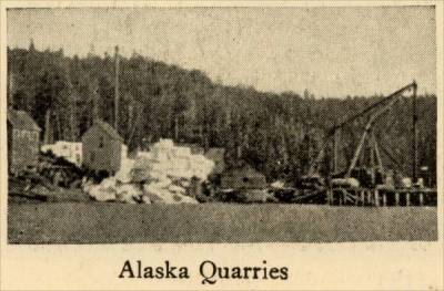
Unloading huge blocks of marble from the Alaskan Quarries of the Vermont Marble Company at the San Francisco Docks.
-
Alaska (?) – Marble Blocks in Yard along Railroad Tracks (There is no information printed on the back of this postcard, although it was a part of a postcard collection of locations in Alaska. Peggy B. Perazzo)
Marble Blocks in Yard along Railroad Tracks (early postcard photograph, possibly in Alaska) 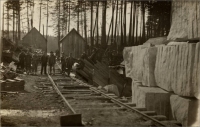
-
Southeast Alaska’s Marble History, presented by Fathom Stone of Whistler, British Columbia.
- Southeastern Alaska – Alaskan
Quarrying Photographs circa 1910 – Location and
date(s) unknown.
Interior of an Alaskan marble quarry circa 1910 
Marble blocks in an Alaskan quarry, circa 1910. 
Marble blocks on Alaskan dock awaiting shipping, circa 1910. 
- Southeastern Alaska – Southeastern Alaska
Marble Deposits (circa 1920) (Marble) (Excerpt from Mineral
Resources of Southeastern Alaska, Bulletin 682, by Ernest
F. Burchard, U. S. Geological Survey, 1920)
The Marble Deposits – Geographic Distribution.
“The mineral lands of southeastern Alaska lie in the Juneau, Skagway, Sitka, Wrangell, and Ketchikan mining districts, the outlines of which are shown on the index map (Pl. I). Deposits of marble have been found in all these districts. On some of them claims have been filed and prospecting has been done, according to regulations, and on some sufficient development work has been done to warrant the issue of patents; but on some of the deposits described herein no claims have yet been filed, and on others little or nothing has been done besides filing claims. In the Juneau district deposits of marble have been noted on the mainland and on Admiralty Island; in the Skagway district marble occurs on the mainland on the east side of Glacier Bay and on several small islands in the bay; in the Sitka district marble forms some of the shore line of the southeastern part of Chichagof Island; in the Wrangell district the marble occurs chiefly on the mainland east of Wrangell Island, but a little has been noted on Kupreanof Island; in the Ketchikan district marble is widespread and abundant, having been found in both the northern and southern parts of Prince of Wales Island and on Kosciusko, Marble, Orr, Heceta, Dall, Long, and Revillagigedo islands. The relations of all these localities are shown on the index map (Pl. I) and Plates II to V and figures 1 and 4 show on a larger scale the geography of the several marble-bearing localities. Such geologic maps of this region as have been published are mainly of a reconnaissance nature and are included in Survey Bulletins 287 and 347. The maps showing the geography of the region in greatest detail are the charts issued by the Coast and Geodetic Survey, Department of Commerce, and these maps served as bases for Plates II to V and figures 1 and 4. The principal Coast and Geodetic Survey charts covering the areas containing the marble deposits of southeastern Alaska are as follows:
1800. Revillagigedo Island and southeastern part of Prince of Wales Island.
8150. Western part of Prince of Wales Island, Kosciusko, Marble, Orr, Hecata, Dall, and Long islands.
8200. Northern part of Prince of Wales Island, Kupreanof Island, Wrangell Island, and mainland to the east.
8250. Eastern part of Chichagof Island and western part of Admiralty Island.
8300. Mainland on Stephens Passage.
8306. Glacier Bay.
“These charts, with the exception of 8306, which is on a scale of 1:160,000, or about 0.39 inch to 1 statute mile, are on a scale of 1:200,000, or approximately 0.32 inch to the statute mile.”
- Southeastern Alaska – Geologic Reconnaissance
Map of southeastern Alaska with
index to marble deposits. (Marble) (Excerpt from Mineral
Resources of Southeastern Alaska, Bulletin 682, by Ernest
F. Burchard, U. S. Geological Survey, 1920)
(Map caption) Plate I. Geologic Reconnaissance Map of southeastern Alaska with index to marble deposits. (pp. 10)
-
Southeast Alaska – Marble Quarry in southeastern Alaska (Photograph from the Wickersham State Historic Site. Photographs, 1882-1930s. ASL-PCA-277 collection; Photo ID: Identifier ASL-P277-002-159; taken between 1895 to 1918; Alaska State Library - Historical Collections.)
- Southeastern, Alaska – Marble
Deposits on Revillagigedo Island (circa
1920) (Marble) (Excerpt from Mineral Resources
of Southeastern Alaska, Bulletin 682, by Ernest F. Burchard,
U. S. Geological Survey, 1920)
Important Undeveloped Deposits.
“Some of the undeveloped deposits of marble described in this paper (those from which no stone has been quarried) possess elements of possible economic value, but not all of them seem to warrant prospecting, and even those that have appeared most favorable on cursory inspection may prove on prospecting to be totally unfit for exploitation. The more important of these undeveloped deposits, whose surface appearance and general relations suggest that further investigations might be warranted whenever the demand for marble on the Pacific coast exceeds the present production, are mentioned in the following summary...:
“As to the other undeveloped deposits described in this report less encouragement can be given regarding the possibilities of profitable exploitation under present conditions. For special decorative purposes, where cost is a minor consideration, some very unusually banded marble may be obtained from the schistose deposits on Admiralty Island near Point Hepburn (No. 14) and north of Marble Cove (Nos. 15 and 16), but it is doubtful whether these deposits can be quarried in competition with the more homogeneous calcite marbles already developed. About the shores and islands of Glacier Bay (Nos. 2 to 8) there are indications of an abundance of marble, but it is probable that the remoteness of this bay from settlements, the scarcity of large timber in the vicinity, and the uncertainties of navigation will retard active quarrying there.”
- Admiralty Islands, Alaska -
Map showing marble deposits examined on Chichagof and Admiralty
Islands (circa 1920) (Marble)
Plate II. Map showing marble deposits examined on Chichagof and Admiralty Islands (Alaska). From Coast and Geodetic Survey chart No. 8306. (pp. 26) 
- Admiralty Island, Alaska – the Admiralty Island
Marble Deposits (circa 1907) (Marble) Excerpt
from “The Building Stones and Materials of Southeastern
Alaska,” by
Charles W. Wright, in Mineral Resources of Alaska: Report
on Progress of Investigations in 1907, Bulletin 345, by
Alfred H. Brooks and Others, Department of the Interior, United
States Geological Survey, 1908, pp. 122.
Admiralty Island.
“Marble is known to occur at several localities on Admiralty Island, namely, at Marble Bluffs, on the west coast; at Square Cove, just north of Marble Bluffs; and in Hood and Chiak bays, south of Kilisnoo. At these points some of the marble is of good quality, but most of the deposits contain silica and pyrite and the rock is not of much value. The deposits at Marble Bluffs are apparently more extensive and of better grade than those at the other localities.”
- Admiralty Island, Alaska – Limestone & Marble
Deposits (circa 1920) (Limestone & Marble) (Excerpt
from Mineral Resources of Southeastern Alaska, Bulletin
682, by Ernest F. Burchard, U. S. Geological Survey, 1920)
Admiralty Island.
“The shores of Admiralty Island from Mansfield Peninsula to Chaik Bay and from Pybus Bay to the head of Seymour Canal are made up largely of limestone and schist. The general distribution of rocks along the shore line of this island is shown in Bulletin 287,* although slight modifications should be made as a result of observations during this study of marble deposits. For instance, the ‘Marble Bluffs’ on Chatham Strait, nearly opposite Tenakee Inlet on Chichagof Island, have been found to be composed of quartz monzonite, a light-colored granitic rock, instead of marble, as heretofore popularly supposed. In parts of the limestone belts the limestone has been metamorphosed to marble, some of which is of good quality and some of which is schistose. Exposures of marble were examined on the west shore between Cube Point and Point Hepburn, also south of ‘Marble Bluffs’ and in Hood Bay, and search for marble was made at many intermediate points and in Pybus Bay.
(* Footnote 1, page 48: Wright, C. W., A reconnaissance of Admiralty Island, Alaska: U. S. Geol. Survey Bull. 287, pp. 138-154, pl. 33, 1906. This bulletin is out of stock at the Survey but may be purchased from the Superintendent of Documents, Washington, D.C., for 75 cents(in 1884).) ” - Admiralty Island, Hood Bay, Alaska – Marble Deposit
at Hood Bay (circa 1920) (Marble) (Excerpt from Mineral
Resources of Southeastern Alaska, Bulletin 682, by Ernest
F. Burchard, U. S. Geological Survey, 1920)
Hood Bay.
“Some fine-grained white marble was noted in two places on the northeast shore of Hood Bay (No. 18), almost due east of Distant Point. In hand samples this is a very beautiful marble, which takes a good polish, but its availability in large blocks and in large quantity is questionable. Mr. Dale finds that the grain diameter of this marble ranges between 0.05 and 0.3 millimeter but mostly between 0.25 and 0.2, and estimates the average at 0.091 millimeter. The grade is thus a trifle finer than 2 (very fine). The texture appears even. Mr. Dale mentions the presence of grains of quartz and feldspar from 0.037 to 0.148 millimeter in diameter, but these were not recognized by Mr. Loughlin. “The marble is associated with schist and becomes schistose in the direction of the strike, which is apparently N. 70° E. The beds are rather slabby and dip about 20° SE., although the angle of dip is variant. The surface rock is jointed into small rectangles, a few inches to 2 or 3 feet across. Veins and eyes of quartz were noted in the marble. One of the exposures measured about 500 feet between its borders of schist and possibly 100 feet on the strike, between mean tide level and the wooded bluff. The rock father up the hill was found to have a schistose texture. At the other exposure, about a quarter of a mile to the southeast, the material is similar in character but has been much fractured and carries considerable quartz in eyes and veins.”
- Admiralty Island, Chaik Bay, Pybus Bay, & Gambier
Bays, Alaska – Marble Deposits at Chaik Bay, Pybus Bay, & Gambier
Bays (circa 1920) (Marble) (Excerpt from Mineral
Resources of Southeastern Alaska, Bulletin 682, by Ernest
F. Burchard, U. S. Geological Survey, 1920)
Chaik, Pybus, and Gambier Bays.
“Wright* states that small belts of marble occur at Chaik Bay, on the west side of the island, at Gambier and Pybus bays, on the southwest side. Neither Chaik Bay nor Gambier Bay was examined by the writer. On the west side of Pybus Bay, about 2 ½ miles from the entrance, is a small area of gray crystalline limestone with bands and nodules of chert. The beds strike north and dip 72° E. At the end of a small point where the beds are exposed they are thin and much fractured, but in an overhanging cliff facing a small cove the appear to be more massive. These beds are abundantly fossiliferous, and in the cliff the fossils appear in relief on the weathered faces of the beds. A collection of these fossils made by the writer contained the following species, as determined by George H. Girty, who states that they are supposed to be of Artinskian age, or well along in the Carboniferous:
(* Footnote 1, page 55: Wright, C. W., A reconnaissance of Admiralty Island, Alaska: U. S. Geol. Survey, Bull. 287, p. 154, 1906.)
Lot 38. Fossils from west side of Pybus Bay, 1913:
Batostomella sp.
Camarophoria aff. C. margaritovi.
Chonetes aff. C. morahensis.
Productus aff. P. timanicus.
Productus aff. P. gruenwaldti.
Productus semireticulatus.
Productus aff. P. multistriatus.
Productus sp.
Telgulifera ? sp.
Dielasma sp.
Rhynchopora aff. R. nikitini.
Spirifer aff. S. cameratus.
Spiriferella ? artica.
Squamularia aff. S. Perplexa.
Modiola ? sp.
Murchisonia ? sp.
“At several points on the west side and on the east side near the head of Pybus Bay is exposed a much fractured cherty magnesian limestone containing crinoid stems and small brachiopods. The shore line of Pybus Bay, except at the mouth of the bay, is mapped by Wright* as limestone and schist, but by far the greater part of the west shore line is made up of a dark metamorphosed shale. This dark rock is regarded by Edwin Kirk as of Triassic age. No rock that could be termed commercial marble was discovered in Pybus Bay.
(* Footnote 1, page 55: Wright, C. W., A reconnaissance of Admiralty Island, Alaska : U. S. Geol. Survey, Bull. 287, pl. 33, 1906.) ”
- Admiralty Island, Marble Cove, Alaska – Marble
Deposit at Marble Cove (circa 1920) (Marble) (Excerpt
from Mineral Resources of Southeastern Alaska, Bulletin
682, by Ernest F. Burchard, U. S. Geological Survey, 1920)
Marble Cove.
“On Chatham Strait from a point 4 miles south of ‘Marble Bluffs’ to a point 1 mile north of a small notch in the shore, which will here be called Marble Cove, there is a deposit of marble that possesses considerable scientific interest and possibly some commercial value. At this locality (No. 15) the marble is interbedded with bands of gray and green mica schist and white to gray variously banded quartz schist. The marble layers range from 1 inch to 3 or 4 feet in thickness. The bands of mica schist are generally 1 inch to 5 or 6 inches thick, and some of the bands of quartz schist are a little thicker but rarely exceed 1 foot. The marble is medium grained and is gray, white, pink, and green. All of it is susceptible of a fair polish and the quartzite takes a glassy polish. The beds strike N. 60° - 65° W. and are nearly vertical. They are cut by small dikes of dark-green layers. Folds are also exhibited by the varicolored bands. (See Pl. VIII, A.) This outcrop is exposed in a strip about 50 feet thick along the beach for a quarter of a mile or more and is partly submerged at high tide. (See Pl. VII, A.) It is bounded by a bluff which also contains alternate bands of marble and schist, the schist predominating. In strike with these beds, 1 to 1 ½ miles toward the southeast (No. 16), a similar body of banded marble, schist, and quartzite is exposed by a steep mountain stream.
Pl. VIII. A. Schistose varicolored marble from Chatham Strait Beach of Admiralty Island, 1 mile north of Marble Cove (Alaska). (pp. 50) 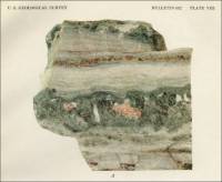
Pl. VII. A. Schistose marble on wave-scoured beach of Chatham Strait, Admiralty Island, north of Marble Cove (Alaska). (pp. 50) 
“Several thin sections of marble from this locality were examined by T. N. Dale and G. F. Loughlin. One section from a medium-grained white band in a schistose mass showed a grain diameter of 0.05 to 1.12 millimeters, mostly 0.12 to 0.62 millimeter, with an estimated average of 0.23 millimeter. The texture of this rock is uneven. Sparse grains of quartz, pyroxene, and tremolite were noted, also a few lenses of these minerals reaching 3 millimeters in length. The material is a slightly quartzose and pyroxenic calcite marble.
“Another section showed a medium-grained schistose material, with alterations of white and green bands. The white band consists of calcite having a grain diameter ranging from 0.075 to 0.62millimeter, but mostly from 0.12 to 0.37 millimeter. The estimated average diameter 0.166 millimeter. It has an uneven texture. The calcitic portion contains many particles and streaks of tremolite and pyroxene with a little quartz. On either side of the calcite band is a band of epidote 0.1 inch wide. This rock is a calcite marble with pyroxene, epidote, tremolite, and quartz. In a section of the quartz schist the quartz grains form minute specks as much as 3 millimeters in diameter. The average grain, except in the coarse streak, is about 0.12 millimeter. Thin streaks of carbonate and augite give the schistose character. One band noted was composed chiefly of pale-green augite, 1 millimeter in maximum length but averaging 0.2 millimeter, rimmed in places by a little common hornblende. The other main constituent is quartz. A few grains of pyrite and titanite are present.
“Another sample of medium-grained schistose material with white and green bands, but coarser than the material described in the preceding paragraph, shows a grain diameter of 0.125 to 1.37 millimeters, mostly 0.25 to 0.75 millimeter, with an estimated average diameter of 0.332 millimeter. The texture is uneven, the rock containing sparse pyroxene grains 0.05 to 0.37 millimeter in diameter. A central light-greenish band or vein averaging 0.1 inch in width crosses the section; it consists of green pyroxene with a little quartz and a very little pyrite. Minute specks of titanite are common. This band is crossed at right angles by numerous microscopic joints.
“Still another section showed medium-grained greenish pyroxenic marble in which the grain diameter ranges from 0.074 to 1.3 millimeters, mostly 0.16 to 0.74 millimeter, and the estimated average is 0.24 millimeter. The texture is uneven and irregular. The calcite is closely twinned, and many of the grains have curved twinning, indicating secondary movement. The section contains sparse grains of pyroxene 0.17 to 1.5 millimeters in diameter, a few quartz grains, a quartz lens 1.25 millimeters long, and a little tremolite.
“The wave-washed beach exposures of this banded rock afford some sections of very attractive material, and if it can be quarried advantageously it should be possible to obtain a large quantity of stone here that might be suitable for certain classes of interior decorative work. This rock, which consists of alternating layers of material of variant degrees of hardness, is not so easily sawed and polished as a more homogeneous rock. However, large blocks of similarly banded schistose marble found on Moira Sound, Prince of Wales Island, have been cut and polished and yielded very handsome finished slabs.” - Admiralty Island, near Marble Cove, Alaska – Marble
deposit at Marble Cove (circa 1920) (Marble) (Excerpt
from Mineral Resources of Southeastern Alaska, Bulletin
682, by Ernest F. Burchard, U. S. Geological Survey, 1920)
“About a quarter of a mile to a third of a mile north of Marble Cove occurs another strip of attractive marble. The beds here also strike N. 60° - 65° W. and stand nearly vertical. The total width (or thickness) of the exposure is 115 to 130 feet. It extends 500 to 600 feet along the beach and in places forms a bluff 40 feet high. From 40 to 50 feet of these beds at the northeast side consist of medium-grained gray marble, closely banded with thin dark-gray layers. The southwest 75 to 80 feet is coarse-grained yellowish-white marble. Dikes of basaltic rock cut the beds, but not so closely as to interfere seriously with quarrying. A section of medium-grained gray and white banded marble from this locality showed a grain diameter of 0.114 to 1.71 millimeters, mostly 0.38 to 0.95 millimeter, with an estimated average of 0.38 millimeter. According to the Rosiwal measurement, the average grain diameter is 0.014 inch, or 0.355 millimeter. The texture is slightly uneven. Much close twinning was noted, also a few particles of pyrite (?).”
“At the north side of the entrance to Marble Cove (No. 17) is exposed a fine-grained white marble. The rock strikes N. 60° - 65° W. but is so badly fractured that the bedding is indistinct. The quantity of stone of this grade seems to be small, as toward the north the material passes into coarser yellowish marble. A section of the fine-grained white marble shows that most of the crystals are twinned. The grain diameter ranges from 0.05 to 0.325 millimeter, mostly between 0.125 and 0.25 millimeter. The estimated average diameter is 0.096 millimeter. The texture does not show interlocked particles. There are some cloudy (graphitic ?) areas of calcite as much as 0.4 inch long and 0.1 inch wide in which the twinning planes bisect the acute angle of the cleavage rhomb and some of the grains are very large. The following analysis of this sample, by R. K. Bailey, shows that it is high in magnesium:
Analysis of white marble (from Admiralty Island, north side of Marble Cove).
Insoluble matter – 0.91
Calcium carbonate (CaCO3) – 61.11
Magnesium carbonate (MgCO3) – 39.10
- Admiralty Island, near Marble Cove, Alaska – Marble
deposit at Marble Cove (circa 1920) (Marble) (Excerpt
from Mineral Resources of Southeastern Alaska, Bulletin
682, by Ernest F. Burchard, U. S. Geological Survey, 1920)
“About a quarter of a mile to a third of a mile north of Marble Cove occurs another strip of attractive marble. The beds here also strike N. 60° - 65° W. and stand nearly vertical. The total width (or thickness) of the exposure is 115 to 130 feet. It extends 500 to 600 feet along the beach and in places forms a bluff 40 feet high. From 40 to 50 feet of these beds at the northeast side consist of medium-grained gray marble, closely banded with thin dark-gray layers. The southwest 75 to 80 feet is coarse-grained yellowish-white marble. Dikes of basaltic rock cut the beds, but not so closely as to interfere seriously with quarrying. A section of medium-grained gray and white banded marble from this locality showed a grain diameter of 0.114 to 1.71 millimeters, mostly 0.38 to 0.95 millimeter, with an estimated average of 0.38 millimeter. According to the Rosiwal measurement, the average grain diameter is 0.014 inch, or 0.355 millimeter. The texture is slightly uneven. Much close twinning was noted, also a few particles of pyrite (?).”
“At the north side of the entrance to Marble Cove (No. 17) is exposed a fine-grained white marble. The rock strikes N. 60°- 65° W. but is so badly fractured that the bedding is indistinct. The quantity of stone of this grade seems to be small, as toward the north the material passes into coarser yellowish marble. A section of the fine-grained white marble shows that most of the crystals are twinned. The grain diameter ranges from 0.05 to 0.325 millimeter, mostly between 0.125 and 0.25 millimeter. The estimated average diameter is 0.096 millimeter. The texture does not show interlocked particles. There are some cloudy (graphitic ?) areas of calcite as much as 0.4 inch long and 0.1 inch wide in which the twinning planes bisect the acute angle of the cleavage rhomb and some of the grains are very large. The following analysis of this sample, by R. K. Bailey, shows that it is high in magnesium:
Analysis of white marble (from Admiralty Island, north side of Marble Cove).
Insoluble matter – 0.91
Calcium carbonate (CaCO3) – 61.11
Magnesium carbonate (MgCO3) – 39.10
- Blake Island, Alaska – See: Ham Island, Alaska – Crystalline Limestone on Ham Island.
- Calder, Alaska
See the “Prince of Wales Island” quarry section of Alaska on this web site.
- Chichagof Islands, Alaska -
Map showing marble deposits examined on Chichagof and Admiralty
Islands (circa 1920) (Marble)
(Map caption) Plate II. Map showing marble deposits examined on Chichagof and Admiralty Islands (Alaska). From Coast and Geodetic Survey chart No. 8306. (pp. 26) - Chichagof Island, Alaska – Limestone & Marble
Deposits on Chicagof Island (circa
1920) (Marble) (Excerpt from Mineral Resources
of Southeastern Alaska, Bulletin 682, by Ernest F. Burchard,
U. S. Geological Survey, 1920)
Chichagof Island.
“The eastern shore of Chichagof Island from Peril Strait northward to Icy Strait is composed largely of Paleozoic rocks, including limestone, sandstone, phyllite, schists, and greenstone lavas and tuffs. Between Peril Strait and Point Augusta there is considerable limestone and some marble. The most promising deposits were noted in Tenakee Inlet and in Basket Bay and vicinity.”
- Chichagof Island, Alaska – Limestone & Marble
Deposits on Chicagof Island (circa
1920) (Marble) (Excerpt from Mineral Resources
of Southeastern Alaska, Bulletin 682, by Ernest F. Burchard,
U. S. Geological Survey, 1920)
Chichagof Island.
“The eastern shore of Chichagof Island from Peril Strait northward to Icy Strait is composed largely of Paleozoic rocks, including limestone, sandstone, phyllite, schists, and greenstone lavas and tuffs. Between Peril Strait and Point Augusta there is considerable limestone and some marble. The most promising deposits were noted in Tenakee Inlet and in Basket Bay and vicinity.”
- Chignik, Alaska – the Chignike Quarry (present-day quarry operation)
- Chugiak, Alaska - Rock Alaska LLC. Quarry (present-day company), Old Glenn Highway, Chugiak, AK 99567; (907) 688-3500.


A photograph of the Chignike Quarry listed as “Photograph 10: Chignik Quarry” in Knik Arm Crossing – Final Potential Armor and Rock Quarries Technical Report, Agreement No: P 42070, Federal Project No: ACSTP-0001(277), Aksas Project No: 56047, Prepared for: Knik Arm Bridge and Toll Authority, Anchorage, AK 99501, Prepared by: PND Engineering, Inc., January 2006.
-
Chugiak, Alaska – Rock Alaska Quarry Boulder (Photograph), presented on the Niebrugge Studio Studio Art Blog.
- Coco Harbor, Alaska – Marble Deposit
in Coco Harbor (circa 1915) (Marble) (Excerpt from “The
Marbles of Alaska” in Stone: An Illustrated Magazine,
Vol. XXXVII, No. 11, November 1916, pp. 583-584.)
“Interests in the development of marble properties continues, especially in the Ketchikan district….”
“Marble was also noted on the northeast side of Coco Harbor, half a mile from the head. Where it crops out along the beach it is evidently faulted against gray limestone. Back from the beach the out-crops are too few to determine its relations accurately. The marble is white to gray. Much of it is very fine grained and pure white, and some parts are coarsely crystalline, with large flashing crystals of calcite. Pyrite is not abundant but was noted in places as veinlets and disseminated particles. Marble claims are held at a number of other localities on Dall Island, but they were not visited in 1915.”
- Cook Inlet, Alaska – the Cottonwood Bay / Diamond Point Granite Quarry (Granite) (proposed active quarry circa 2012) The following information is from a memo from the Fish and Wildlife Service, U. S. Department of the Interior, Anchorage, Alaska, dated June 28, 2012. (Other documents relating to this quarry are available, although none of them appear to indicate the quarry was approved.)
- Dall Island, Alaska – Marble
Deposits on Dall Island (circa
1920) (Marble) (Excerpt from Mineral Resources
of Southeastern Alaska, Bulletin 682, by Ernest F. Burchard,
U. S. Geological Survey, 1920)
Important Undeveloped Deposits.
The above document states that the proposed Diamond Point granite quarry was “located at the confluence of Cottonwood Bay and Lliamna Bay in Cook Inlet, Alaska.”
- Dall Island, American Bay,
Alaska – Marble Deposit at American
Bay (circa 1920) (Marble) (Excerpt
from Mineral Resources of Southeastern Alaska, Bulletin
682, by Ernest F. Burchard, U. S. Geological Survey, 1920)
American Bay.
“A deposit of schistose marble on the south side of American Bay (No. 43) is reported by Mr. Waters. The deposit is more than 500 yards wide, stands about vertical, strikes east, and is mostly covered by moss and timber. The marble is reported to be both fine and coarse grained and to contain mica, but no mention is made of its color, and although a sample as sent it did not reach Washington.
“Limestone and marble are also reported in the vicinity of Kaigani Harbor, but no descriptive details are available.”
- Dall Island, Baldy Bay,
Alaska – Marble Deposit on Baldy
Bay (circa 1920) (Marble) (Excerpt
from Mineral Resources of Southeastern Alaska, Bulletin
682, by Ernest F. Burchard, U. S. Geological Survey, 1920)
Baldy Bay.
“At High Point, on Baldy Bay (No. 41), marble was noted by Mr. Waters, who reports a ledge about 200 feet wide consisting of fine-grained white material, very much fractured on the surface. The ledge strikes west where noted, but the rocks in this locality are very much disturbed and dip and strike in many directions. Samples sent to the Survey are grayish to yellowish white and also bluish-gray medium-grained calcite marble containing in places grains of pyrite. The rock is of medium hardness. The marble beds are associated with slate.”
- Dall Island, Breezy Bay,
Alaska – Marble & Limestone Deposits on Breezy
Bay (circa 1920) (Marble & Limestone) (Excerpt
from Mineral Resources of Southeastern Alaska, Bulletin
682, by Ernest F. Burchard, U. S. Geological Survey, 1920)
Breezy Bay.
“In the autumn of 1914 and early in 1915 W. C. Waters examined the east shore of Dall Island and portions of Long Island and sent to the Survey samples of limestone and marble collected from several localities in these areas.
“Mr. Waters’s notes show two narrow areas of marble striking in a westerly direction from the northern part of Breezy Bay (No. 38) and an area of limestone a short distance to the south of the marble. The color of the sample of marble from Breezy Bay is uniformly light gray, and the texture is generally fine grained and dense as seen under a field lens. The rock is evidently composed mainly of calcium carbonate. The ledge is reported to be about 100 feet wide and to stand nearly vertical, with a west-southwest strike. So far as explored there was little cover besides moss over the ledge.”
- Dall Island, Cape
Muzon, Alaska – Marble
Deposit at Cape Muzon (circa
1920) (Marble) (Excerpt from Mineral Resources
of Southeastern Alaska, Bulletin 682, by Ernest
F. Burchard, U. S. Geological Survey, 1920)
Cape Muzon.
“A bed of schistose marble 10 to 100 feet wide and 2 miles long ‘in the vicinity of Cape Muzon’ is reported by Mr. Waters, who notes that the bed strikes west and stands nearly vertical. The material is reported to be white, pink, and green. A sample received by the Survey is of brownish-pink color, medium grain, and bright appearance. From notes on a chart sent by Mr. Waters it appears probable that this marble crops out west of McLeod Bay (No. 44).
- Dall Island, Breezy
Bay, Alaska – Marble & Limestone
Deposits at Coco Harbor (circa
1920) (Marble & Limestone) (Excerpt from Mineral
Resources of Southeastern Alaska, Bulletin 682,
by Ernest F. Burchard, U. S. Geological Survey, 1920)
Coco Harbor.
“Marble is reported to occur on the north shore and limestone on the south shore of Coco Harbor (No. 40). From W. C. Waters’s notes it is inferred that the beds strike west-northwest and dip south and that large dikes of ‘greenstone’ cut the beds at intervals of 30 to 40 feet, with small dikes between.”
“Mr. Chapin also noted the marble on the northwest side of Coco Harbor half a mile from the head. He writes in regard to it:
“‘Where it crops out along the beach it is evidently faulted against gray limestone. Back from the beach the outcrops are too few to determine its relations accurately. The marble is white to gray. Much of it is very fine grained and pure white, and portions of it are coarsely crystalline with large flashing crystals of calcite. Pyrite is not abundant but was noted in places as veinlets and disseminated particles.’
“A sample of fine-grained white calcite marble was sent to the Survey from this locality by Mr. Waters. It appears to be of good white color but is a little soft and resembles the marble on the shore of Hood Bay, Admiralty Island (p. 54), examined by the writer. It is reported to contain so much iron oxide in places as to be of doubtful value. The ledge is said to be about 200 feet wide and to be covered mainly by 2 to 3 feet of earth, moss, and roots.”
- Dall Island, Grace Harbor,
Alaska – Marble Deposit at Grace
Harbor (circa 1920) (Marble) (Excerpt
from Mineral Resources of Southeastern Alaska, Bulletin
682, by Ernest F. Burchard, U. S. Geological Survey, 1920)
Grace Harbor.
“A bed of white marble 6 or 8 to 20 feet wide having an easterly strike was noted by Mr. Waters half a mile south of the entrance to Grace Harbor (No. 42). Samples sent to the Survey are fine grained, dense, and very hard. The color is white, but some of the rock shows clouds of a faint brownish-yellow color.”
- Dall Island, View Cove, Alaska – Marble
Deposits at View Cove (circa 1916) (Marble) (Excerpt
from “The Marbles of Alaska” in Stone:
An Illustrated Magazine, Vol. XXXVII, No. 11, November
1916, pp. 583-584.)
“Interests in the development of marble properties continues, especially in the Ketchikan district….Marble prospecting has been continued at other places on Dall Island and Revillagigedo Island, and some commercial marble of very good grade has been located. These marble deposits will be described in more detail in a forth-coming bulletin….”
“Marble deposits occur at a number of places on the east coast of Dall Island. Near the head of View Cove a stream that enters from the southwest flows in a gorge following joint planes in the marble. This stream was traversed from the beach for half a mile, and for that distance the beds strike about northwest, directly across the course of the stream, and stand nearly vertical. Most of the marble seen is a pearl to gray in color, mottled and veined in white. At one locality occurs a 4-foot band of yellow marble with a green stripe, and bordering it is white marble, mottled with yellow. The yellow marble takes a good polish and has a warm, soft tone. Associated with these beds is a little bluish-black marble. A polished specimen shows a black field variegated with dark-gray areas and tiny veinlets of white calcite.”
- Dall Island, View
Cove, Alaska – Marble
Deposits at View Cove (circa
1920) (Marble) (Excerpt from Mineral
Resources of Southeastern Alaska, Bulletin 682,
by Ernest F. Burchard, U. S. Geological Survey, 1920)
View Cove.
“Mr. Chapin also visited certain portions of the east coast of Dall Island. With regard to a deposit near View Cove (No. 39) he furnishes the following notes:
“‘Marble deposits occur on the east coast of Dall Island at a number of places. Near the head of View Cove a stream that enters from the southwest flows in a gorge following joint planes in the marble. This stream was traversed from the beach for half a mile and in that distance the bed strike about northwest, directly across the course of the stream, and stand nearly vertical. Most of the marble seen is pearl to gray in color and mottled and veined with white. At one locality occurs a 4-foot band of yellow marble with a green stripe, and bordering it is white marble mottled with yellow. The yellow marble takes a good polish and has a warm, soft tone. Associated with these beds is a little bluish-black marble. A polished specimen shows a black field variegated with dark-gray areas and tiny veinlets of white calcite.’
“Mr. Waters also reports that several colored varieties of marble occur here, including white, pearl, light with black veining, black, green, and yellow, and has sent samples of the pearl-colored, gray-veined, yellow, green, and black varieties to the Survey. The pearl-colored rock, in the hand sample, gives brisk effervescence with hydrochloric acid and is uniformly fine grained and dense, except for a few thin streaks of crystalline calcite. The color is not uniform but shows gradations from pearl to gray. A few small specks of pyrite were noted along a fracture plane. A thin section of this marble was examined by G. F. Loughlin, who reports that the material shown is nearly all even-grained calcite with a few large grains (single or aggregates) as much as 2 millimeters in diameter. The fine grains range from 0.01 to 0.3 millimeter in diameter and average about 0.08 millimeter. The grade of texture is therefore fine. A very few minute black grains, some certainly of pyrite, were noted; the largest was 0.035 millimeter in diameter. A few flakes of graphite may be included. The section also shows a very few grains of quartz 0.03 or 0.04 millimeter in diameter.
“The gray-veined material consists of medium-grained calcite with veins and spots of darker-gray finer-grained material showing close-folded structure. If large slabs of this marble could be obtained the effect, after polishing, would be very handsome.
“The black marble is bluish-black in the unpolished sample. It is a fine-grained, dense high-calcium limestone, possessing the color and density characteristic of rocks that are susceptible of high polish and that show a deep black color on polished surfaces. The rock is brittle and shows fine fractures recemented with calcite, and for this reason it is probably questionable whether large thin slabs could be prepared from it.
“The yellow sample (see Pl. XIX, B) is generally fine-grained, dense high-calcium marble. It takes a high polish, which brings out well the color, a warm light brownish yellow that resembles the yellow areas in the Italian Siena marble. This color in the hand sample, which is 3 ½ by 4 inches, is not uniform but becomes slightly lighter toward one edge. This is a very handsome marble, and if it can be obtained in large quantities and the conditions for quarrying and transportation are favorable, the deposit should prove to be very valuable.
“The green marble is also fine grained, and consists mostly of calcite but carries dark streaks of micaceous carbonaceous material with considerable pyrite. The general effect in the hand sample is grayish with clouded areas of grayish green, streaks of black, and here and there mottlings of light gray, giving altogether a very attractive appearance. The rock takes a high polish except along the black streaks, which consist of material harder than calcite.
“The marble in the vicinity of View Cove is all of the calcite variety.”
- Dall Island, View
Cove, Alaska – Marble
Deposits at View Cove (circa
1920) (Marble) (Excerpt from Mineral Resources
of Southeastern Alaska, Bulletin 682, by Ernest
F. Burchard, U. S. Geological Survey, 1920)
View Cove.
“Mr. Chapin also visited certain portions of the east coast of Dall Island. With regard to a deposit near View Cove (No. 39) he furnishes the following notes:
“‘Marble deposits occur on the east coast of Dall Island at a number of places. Near the head of View Cove a stream that enters from the southwest flows in a gorge following joint planes in the marble. This stream was traversed from the beach for half a mile and in that distance the bed strike about northwest, directly across the course of the stream, and stand nearly vertical. Most of the marble seen is pearl to gray in color and mottled and veined with white. At one locality occurs a 4-foot band of yellow marble with a green stripe, and bordering it is white marble mottled with yellow. The yellow marble takes a good polish and has a warm, soft tone. Associated with these beds is a little bluish-black marble. A polished specimen shows a black field variegated with dark-gray areas and tiny veinlets of white calcite.’
“Mr. Waters also reports that several colored varieties of marble occur here, including white, pearl, light with black veining, black, green, and yellow, and has sent samples of the pearl-colored, gray-veined, yellow, green, and black varieties to the Survey. The pearl-colored rock, in the hand sample, gives brisk effervescence with hydrochloric acid and is uniformly fine grained and dense, except for a few thin streaks of crystalline calcite. The color is not uniform but shows gradations from pearl to gray. A few small specks of pyrite were noted along a fracture plane. A thin section of this marble was examined by G. F. Loughlin, who reports that the material shown is nearly all even-grained calcite with a few large grains (single or aggregates) as much as 2 millimeters in diameter. The fine grains range from 0.01 to 0.3 millimeter in diameter and average about 0.08 millimeter. The grade of texture is therefore fine. A very few minute black grains, some certainly of pyrite, were noted; the largest was 0.035 millimeter in diameter. A few flakes of graphite may be included. The section also shows a very few grains of quartz 0.03 or 0.04 millimeter in diameter.
“The gray-veined material consists of medium-grained calcite with veins and spots of darker-gray finer-grained material showing close-folded structure. If large slabs of this marble could be obtained the effect, after polishing, would be very handsome.
“The black marble is bluish-black in the unpolished sample. It is a fine-grained, dense high-calcium limestone, possessing the color and density characteristic of rocks that are susceptible of high polish and that show a deep black color on polished surfaces. The rock is brittle and shows fine fractures recemented with calcite, and for this reason it is probably questionable whether large thin slabs could be prepared from it.
“The yellow sample (see Pl. XIX, B) is generally fine-grained, dense high-calcium marble. It takes a high polish, which brings out well the color, a warm light brownish yellow that resembles the yellow areas in the Italian Siena marble. This color in the hand sample, which is 3 ½ by 4 inches, is not uniform but becomes slightly lighter toward one edge. This is a very handsome marble, and if it can be obtained in large quantities and the conditions for quarrying and transportation are favorable, the deposit should prove to be very valuable.
“The green marble is also fine grained, and consists mostly of calcite but carries dark streaks of micaceous carbonaceous material with considerable pyrite. The general effect in the hand sample is grayish with clouded areas of grayish green, streaks of black, and here and there mottlings of light gray, giving altogether a very attractive appearance. The rock takes a high polish except along the black streaks, which consist of material harder than calcite.
“The marble in the vicinity of View Cove is all of the calcite variety.”
- Dall Island, View Cove, Alaska - Pacific Coast Cement
Co. Limestone Quarry
(Limestone) (Seattle, Washington)
(From Southeastern Coastal Alaska Limestone Terrain
(1944), presented by the Alaska Department of Natural
Resources. The information in the report was taken from
a report "Limestones
of the Pacific Northwest," by Edwin Hodge, industrial
raw materials consultant, September 1, 1944, for the
Bonneville Power Administration. (The link from
which this information was obtained is no longer available.)
<http://wwwdggs.dnr.state.ak.us/scan1/mr/text/MR191-08.PDF>"View Cove; Pacific Coast Cement Co., S. E. Hutton, manager, 1003 Seaboard Bldg., Seattle. Operated by Pacific Coast Cement Co. The property consists of 40 acres of high-grade limestone leased from the U. S. government, containing millions of tons of very uniform rock.
"Rocks: Limestone strikes northwest to Cape Lookout.
"Commercial Considerations: Nautical miles from Dall Island (View Cove) to Ketchikan, 65, Prince Rupert, 115 miles; Seattle, 770 miles; Portland, 920 miles.
(There is detailed information in the article about transportation and production of the limestone.)
"A modern quarry with power plant, drilling equipment, power shovels, crushing plant, storage bins and ship-loading equipment gives low-cost f.o.b. ships. The quarry is operated from April to September..."
"About 25 men produce 100 tons per hour. They produce between 25,000 and 30,000 tons per month when operating, but the quarry capacity is said to be 275,000 tons per month. Production is limited by transportation facilities..."
- Dall Island, View Cove, Alaska
- Pacific
Coast Cement Company Limestone Quarry on at View Cove, Dall
Island (circa 1958) (Limestone) (Excerpts from Southeastern
Alaska’s Mineral Industry, Information Circular
7844, by Alvin Kaufman, United States Department of the
Interior, Bureau of Mines, 1958.)
“From 1928 to 1931 the Pacific Coast Cement Co. operated a limestone quarry on Dall Island. In 1931 the properties were leased to the Superior Portland Cement Co., Inc. Except for 1933-34, the quarry was active for 6 months each year until 1940.
“The Southeastern Alaska area contains numerous deposits of high-grade limestones, many of which appear to be suitable for chemical-grade material. The most promising of these are on Dall, Heceta, Kuiu, Kupreanof, Long, Prince of Wales, Shrubby, and Wadleigh Islands. The limestone deposits on these islands have a calcium carbonate content ranging from 93 to 97 percent. However, the sale of limestones is essentially the movement of a low-cost commodity with prices very rarely exceeding $3 to $5 a ton and most often selling for about $1 a ton; consequently, further exploitation of Alaskan limestone deposits may have to await development of local markets.”
“No experienced mine labor exists in Southeastern Alaska, because no mines have been operated since early in World War II. However, during the active period (1890 to 1943) a good indigenous supply was developed. Reestablishment of a stable mining industry undoubtedly would encourage the evolution of a new generation of skilled miners….”
“Substantial reserves of nonmetals, including limestone and gypsum, also occur in the region. It is doubtful if a market could be found for the gypsum because of new discoveries in the United States, plus the present decline in the building-products industry (circa 1958). Stone has been sent to the Seattle area for use in manufacturing cement; however, the availability of suitable limestones closer to Seattle has since negated this market.”
- Dall Island, View Cove, Alaska
- Pacific
Coast Cement Company Limestone Quarry on at View Cove, Dall
Island (circa 1958) (Limestone) (Excerpts from Southeastern
Alaska’s Mineral Industry, Information Circular
7844, by Alvin Kaufman, United States Department of the
Interior, Bureau of Mines, 1958.)
- Dall Island, View Cove, Alaska - Pacific Coast Cement
Co.
Also see: “Dall Island, Alaska - Superior Portland Cement Inc. Quarry” below.
- Dall Island, View Cove, Alaska – Superior
Portland Cement, Inc. Quarry on Dall Island
(circa 1932) (Limestone) (From Mineral Industry
of Alaska in 1932, by Philip S. Smith, United States
Geological Survey, Bulletin 857-A, 1934.
“The other large enterprise included in this section is the quarrying of great quantities of high-grade limestone rock which is transported to the States and used in the manufacture of cement. This work is conducted by Superior Portland Cement, Inc., under a lease from the Pacific Coast Cement Co. The quarry from which the rock is taken is in southeastern Alaska on Dall Island, between Baldy Bay and Tlevak Strait, about 40 miles west of Ketchikan, and in 1932 was in operation only from May to August. The general practice at this place is to drill the limestone in the quarry, blast it down, and haul it to the crushing plant, where it is broken down to suitable size and stored near the wharf, ready for loading on the steamer for Seattle. The round trip, including loading and unloading, takes less than 10 days. Owing to the fact the producer, transporter, and consumer are all one and the same, it is impossible to arrive at a true market price for the limestone produced by this company. In the table given above it has been necessary to adopt a more or less arbitrary price for the limestone, as a means of including this product with the other mineral resources. The price adopted, however, is believed to be extremely conservative, so that the total value of the output as given probably is not more than the actual cost of mining and transportation, without any charge for the basic raw material, the limestone….”
- Dall Island, View Cove,
Alaska – Superior
Portland Cement, Inc., Quarries on Dall Island (circa
1934) (Limestone) (Excerpts from Mineral
Industry of Alaska in 1934, by Philip S. Smith,
United States Geological Survey, Bulletin 868-A, Government
Printing Office, 1936.)
“Another large enterprise that hitherto has been an important producer in this group but was inactive in 1934 is the quarrying of high-grade limestone rock, which is ground and mixed with other materials to manufacture a cement that is much in demand. In recent years the Superior Portland Cement, Inc., operating under lease from the Pacific Coast Cement Co., has carried on such an enterprise on Dall Island, in the Ketchikan district of southeastern Alaska. From the quarries at this locality the limestone was shipped to the company’s plant near Seattle, where it was further treated. No production was reported from this place in 1934, but the owners expect that work may be resumed there in 1935….”
- Dall Island, View Cove, Alaska – the
Superior Portland Cement, Inc., Quarries on Dall Island
(circa 1935) (Limestone) (Excerpt
from Mineral Industry of Alaska in 1935, by
Philip S. Smith, United States Geological Survey, Bulletin
880-A, Government Printing Office, 1937.)
“The quarrying of limestone as an ingredient of cement afforded much the larger part of the amount credited here to miscellaneous minerals in 1935. This enterprise is conducted by the Superior Portland Cement, Inc., of Seattle, operating under lease form the Pacific Coast Cement Co. The quarries at which this high-grade limestone is mined are on Dall Island, in the Ketchikan district of southeastern Alaska. From the quarries at this locality the rough stone is shipped in barges to Seattle, where it is treated and mixed with the other constituents of the cement. This property has been productive for several years, but it was not in operation in 1934, and in 1935 it was operated only from April through September….”
- Dall Island, View Cove, Alaska – the Superior
Portland Cement, Inc., Quarries on Dall Island (circa 1936)
(Limestone) (From Report of the Commissioner
of Mines to the Governor for the Biennium Ended December 31,
1936, Territory of Alaska.)
“The only quarry in operation during the biennium was that of the Superior Portland Cement, Inc., at View Cove on Dall Island, where a crew of approximately 24 men is employed seasonally.”
- Dall Island, View Cove, Alaska – Superior
Portland Cement, Inc., Limestone Quarry on at View Cove, Dall
Island (circa 1958) (Limestone) (Excerpts from Southeastern
Alaska’s Mineral Industry, Information Circular
7844, by Alvin Kaufman, United States Department of the Interior,
Bureau of Mines, 1958.)
“From 1928 to 1931 the Pacific Coast Cement Co. operated a limestone quarry on Dall Island. In 1931 the properties were leased to the Superior Portland Cement Co., Inc. Except for 1933-34, the quarry was active for 6 months each year until 1940.
“The Southeastern Alaska area contains numerous deposits of high-grade limestones, many of which appear to be suitable for chemical-grade material. The most promising of these are on Dall, Heceta, Kuiu, Kupreanof, Long, Prince of Wales, Shrubby, and Wadleigh Islands. The limestone deposits on these islands have a calcium carbonate content ranging from 93 to 97 percent. However, the sale of limestones is essentially the movement of a low-cost commodity with prices very rarely exceeding $3 to $5 a ton and most often selling for about $1 a ton; consequently, further exploitation of Alaskan limestone deposits may have to await development of local markets.”
“No experienced mine labor exists in Southeastern Alaska, because no mines have been operated since early in World War II. However, during the active period (1890 to 1943) a good indigenous supply was developed. Reestablishment of a stable mining industry undoubtedly would encourage the evolution of a new generation of skilled miners….”
“Substantial reserves of nonmetals, including limestone and gypsum, also occur in the region. It is doubtful if a market could be found for the gypsum because of new discoveries in the United States, plus the present decline in the building-products industry (circa 1958). Stone has been sent to the Seattle area for use in manufacturing cement; however, the availability of suitable limestones closer to Seattle has since negated this market.”
- Dall Island, View Cove,
Alaska – Superior
Portland Cement, Inc., Quarries on Dall Island (circa
1934) (Limestone) (Excerpts from Mineral
Industry of Alaska in 1934, by Philip S. Smith,
United States Geological Survey, Bulletin 868-A, Government
Printing Office, 1936.)
- Dall Island, View Cove, Alaska – View Cove
Quarry & Loading Dock Photograph (The
following photograph can be found in SitNews:
Stories in the News, “Mining,
Once Ketchikan’s Principal Industry,” by
David Kiffer, July 28, 2006. (This article includes
a section on the marble quarries in the Ketchikan
area of southeastern Alaska.)
Stone quarry photo captions included in article:
“S.S. Diamond Cement loading limestone at View Cove, 1938”
“Dock and quarry at View Cove”
- Dall Island, View Cove, Alaska - The Ghost Town of View Cove (and Limestone Quarry), Dall Island, Alaska, presented by Manley Kjonaas (The link from which this entry was obtained is no longer available.) <http://www.geocities.com/mkjonaas2/index.htm>
- Dall Island, Waterfall Bay, Waterfall Bay, Alaska
- Marble Deposits on Waterfall Bay (circa 1916) (Marble) (Excerpt
from “The Marbles of Alaska” in Stone:
An Illustrated Magazine, Vol. XXXVII, No. 11,
November 1916, pp. 583-584.)
“According to a report of the United States Geological Survey, the development of the marble industry during 1915 was in a fairly satisfactory condition.…”
“Interests in the development of marble properties continues, especially in the Ketchikan district….Assessment work is being continued by Lhote, Ickis and others on marble deposits near the head of Waterfall Bay, on the west coast of Dall Island. The property comprises 20 claims, including the Eurus, Marble Heart, St. Augustine and Marble Bay groups. The claims are on the steep hillside only a short distance from the head of the bay. “Sections are given of the marble deposits on Waterfall Bay, and it is said that the finest marble in this section is a 13-foot bed of ‘pink-mottled’ white marble. The upper and lower parts of the bed are even-textured, medium to fine-grained white marble, mottled with a very delicate pink tint and veined with irregular threadlike veinlets of yellow. In the central part of the bed the pink color is more pronounced and the rock contains much white mica, a combination that produces a handsome rock. A short distance beyond this point are beds of white pink marble with mottled green areas. These are very handsome and are susceptible of a high polish except where the green minerals predominate. The greater part of the bed is white and pink marble, composed of nearly pure calcite of very fine grain, the individual minerals averaging about 0.05 millimeter in diameter. The base and top of the bed are variegated with green areas which, combined with the pink-mottled white rock, give a very striking effect. Under the microscope the green areas are seen t be sericite, quartz and chlorite; the white and pink rock is essentially calcite. The thick mass of bluish-gray marble at the top of the measured sections contains beds of ornamental marble of commercial value. These beds are black and white, mottled in very intricate pattern, and bluish white, with black veinlets. This rock takes a smooth polish. Marble crops out at several places along the south shore of the bay between the cabin and greenstone contact. Near the cabin an opening has been made on a bed of fine-grained, even-textured white marble carrying flakes of white mica. Another commercial marble on this bay is a fine-grained black variety that takes a good polish. The polished surface shows a black field with white-mottled areas and irregular veinlets of white calcite that give it a pleasing appearance.”
- Dutch Harbor, Alaska – the Dutch Harbor Quarry (present-day quarry operation)
There is a photograph of the Dutch Harbor Quarry listed as “Photograph 9: Dutch Harbor – Indian Hills” in Knik Arm Crossing – Final Potential Armor and Rock Quarries Technical Report, Agreement No: P 42070, Federal Project No: ACSTP-0001(277), Aksas Project No: 56047, Prepared for: Knik Arm Bridge and Toll Authority, Anchorage, AK 99501, Prepared by: PND Engineering, Inc., January 2006.
- Eklutna, Alaska – the Alaska Railroad Corporation – the Eklutna Quarry (Riprap/Ballast) (History of the Eklutna Quarry from the 1940s through 2002)
According to the Supreme Court of the State of Alaska case “Alaska Railroad Corporation and Damco Paving Corporation” (Appellants) v. Native Village of Ilutna, et al. (Appellees), Opinion dated February 15, 2002, the state-owned Alaska Railroad Corporation’s quarry in Eklutna, the quarry was used primarily for rip rap and ballast. In the “Facts and Proceedings” “Facts” section, it is stated that the quarry was owned by the United States Government and was operated by the state-owned Alaska Railroad Corporation “from an undetermined date in the late 1940’s until 1985.” The quarry was active on an as-needed basis. “In 1989 the state obtained full ownership of the quarry, and the Railroad continued to own the quarry to the time of the present litigation.”
- Eklutna, Alaska – the Alaska Railroad Corporation – the Eklutna Quarry (Rip rap/Ballast) (Photograph) A photograph of the Alaska Railroad Corporation Eklutna Quarry is available on Knik Arm Crossing – Final Potential Armor and Rock Quarries Technical Report, Agreement No: P 42070, Federal Project No: ACSTP-0001(277), Aksas Project No: 56047, Prepared for: Knik Arm Bridge and Toll Authority, Anchorage, AK 99501, Prepared by: PND Engineering, Inc., January 2006. (Includes quarry photos and map of quarries.)
-
Eklutna, Alaska – the Alaska Railroad Corporation – the Eklutna Quarry – “Alaska Railroad returns rock quarry to Eklutna: Governor signs authorization in Eagle River,” by Darrell L. Breese, Alaska Star, July 26, 2007.
According to this article, “…Governor Sarah Palin signed legislation authorizing the Alaska Railroad to return a 48.2-acre rock quarry back to Eklutna Inc.” The article stated that the Alaska Railroad Corporation “stopped removing rock from the hills in the quarry in 2001, leaving a large portion of the Eklutna Hill they were carving from still standing.”
“Some of the undeveloped deposits of marble described in this paper (those from which no stone has been quarried) possess elements of possible economic value, but not all of them seem to warrant prospecting, and even those that have appeared most favorable on cursory inspection may prove on prospecting to be totally unfit for exploitation. The more important of these undeveloped deposits, whose surface appearance and general relations suggest that further investigations might be warranted whenever the demand for marble on the Pacific coast exceeds the present production, are mentioned in the following summary….:
“Dall Island has been shown to contain deposits of beautiful marble on both the west and east coasts, and it is probable that the island has not yet been wholly explored. The most promising deposits seem to be those at Waterfall Bay (No. 37) and at View Cove (No. 39), although there are probably good deposits near other bays on the east side of the island. The fine-grained pink and white mottled marble from Waterfall Bay, as well as the white marble with yellow veinlets, are of the highest quality, and the bluish-gray and black varieties take high rank with commercial marbles of similar shades. At View Cove there are several varieties of attractive marble, including pearl-gray fine-grained rock and rock of black, yellow, and grayish-green shades.”
Commercial use of material within this site is strictly prohibited. It is not to be captured, reworked, and placed inside another web site ©. All rights reserved. Peggy B. and George (Pat) Perazzo.