
List of Quarries in Georgia & Quarry Links,
Photographs and Articles
- Palmetto, Georgia – Porphyritic Granite (Granite),
from A Preliminary Report on a Part of the Granites and Gneisses
of Georgia, Bulletin No. 9-A, by Thomas L. Watson, Ph.D., Assistant
Geologist, Geological Survey of Georgia, 1902, pp. 72.
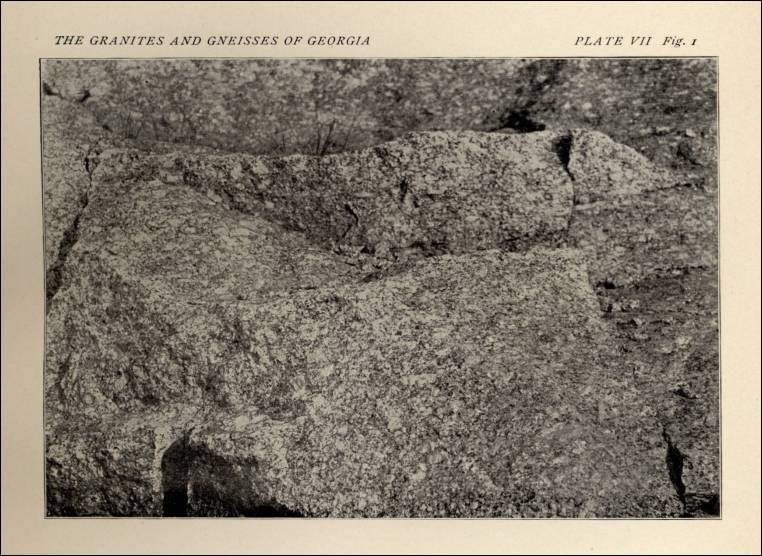
Plate VII. Fig 1. Porphyritic Granite, near Palmetto, Georgia. Fractured surface of a partially worked-up boulder, showing the texture of the Rock (circa 1902) 
Plate VII. Fig. 2. Porphyritic Granite, near Palmetto, Georgia. Eroded Surface of the Residual Clay, from the Porphyritic Granite. 
-
Panola, DeKalb County, Georgia – the Bowers Quarry (Panola Granite) (Excerpt from Geology of The Stone Mountain-Lithonia District, Georgia, by Leo Anthony Herrmann, Georgia State Division of Conservation, Department of Mines, Mining and Geology, Atlanta: 1954, pp. 96. Used with permission. You can read the entire entry for this quarry in the document/chapter on “The Stone Industry (of Georgia).)”
“Bowers Quarry – A small quarry located on the east side of Georgia Route 155 and south of Yellow River at Panola is owned by Mr. Lincoln Bowers.
- Perry (south of), Houston County, Georgia – old Limestone Quarry (Limestone) (from A Report on the Limestones and Marls of the Coastal Plain of Georgia, Bulletin 21, 1910, by J. E. Brantly, Assistant State Geologist, Geological Survey of Georgia, Atlanta, GA: The Blosser Co., 1916, pp. 64)

“The stone is a coarse-grained, porphyritic biotite granite with microcline and biotite phenocrysts up to one-eighth of an inch in diameter. A small amount of magnetite is scattered throughout the rock. the stone is poor quality for quarrying because of the many fractures filled with epidote and chlorite.”
- Pickens County, Georgia – A cut along the Amicalola
Railroad showing the country Rock of the Marble Deposits (Marble),
from A Preliminary Report on the Marbles of Georgia, Bulletin
No. 1, by S. W. McCallie, Assistant State Geologist, Geological Survey
of Georgia, 2nd ed., 1907, pp. 26. (This book is available on Google
Books – Full
View Books.)
Plate IV. A cut along the Amicalola Railroad, showing the country rock (mica-schist) of the marble deposits of Pickens County, Georgia. 
- Pickens County, Georgia – the
Atlanta Marble Company – the Amicalola Quarries (Marble),
from A Preliminary Report on the Marbles of Georgia,
Bulletin No. 1, by S. W. McCallie, Assistant State Geologist, Geological
Survey of Georgia, 2nd ed., 1907. (This book is available on Google
Books – Full View Books.)
Plate XI. The Amicalola Quarries, Atlanta Marble Company, Pickens County, Georgia, with Marble Hill in the distance. (pp. 50) 
Plate L. Entrance to the Candler office building, Atlanta, Georgia, showing carved Georgia marble from the Amicalola quarries, Pickens County, Georgia. (pp. 120) 
Plate XXXIX. Minnesota State Capitol, St. Paul, Minnesota Built of white Georgia marble from the Amicalola quarries, Pickens County, Georgia. (pp. 106) 
Plate XL. An ornamental statue on the Minnesota State Capitol, carved from white marble from Amicalola Quarry No. 1, Pickens County, Georgia. (pp. 108) 
Plate LII. Marble columns and staircase in the basement of the Candler building, Atlanta, Georgia, showing carvings in Georgia marble, from the Amicalola marble quarries, Pickens County, Georgia. (pp. 123) 
- Pickens County, Georgia - Georgia
Marble Co. Quarries (Marble) There are several large dimension
quarries in Georgia operated by the Georgia Marble Company. The stone
is white or light gray with a medium to coarse texture. Sometimes the
marble has veins or dark material. Monuments and buildings are constructed
with the Pickens County marble. (From Industrial Minerals and Rocks,
senior editor, Donald D. Carr; associate editors, A. Frank Alsobrook,
[et al.] 6th ed., Society for Mining, Metallurgy, and Exploration, Littleton,
Colorado, 1994, pg. 25.)
- Pickens County, Georgia – Georgia Marble Co. Marble Quarries. In 1995 this company was operating two marble quarries in Pickens County. The company headquarters is at Tate, Georgia. In 1995 this company was one of the ten leading dimension stone operations in the United States with sales greater than $500,000. (From United States Geological Survey, "Mineral Industries Surveys - Directory of Principal Dimension Stone Producers in the United States in 1995," prepared in January 1997.)
- The Georgia Marble Company quarries are now owned by Polycor (present-day company) You can view the George marbles offered by Polycor in the “Marble Colors” section of the web site.
- Pickens County, Georgia - “An of Pickens County” (including the marble and other minerals), WPA Project, Georgia Department of Archives and History, Adapted from: History of Pickens county, by Luke E. Tate. 1935, presented by Pickens County, Georgia.
- Pickens County, Georgia – “Pit
No. 7” Sericite Schist (Schist), from Report on
The Slate Deposits of Georgia, Bulletin No. 34, by
H. K. Shearer, Assistant State Geologist, Geological Survey of Georgia, 1918, pp. 168.
Plate XII. A. Sericite Schist, “Pit No. 7,” Lost 120, 13th District, 2d section, Pickens County (pp. 168) 
Plate XII. B. Sericite Schist, “Pit No. 8,” Lost 120, 13th District, 2d Section, Pickens County (pp. 168) 
Plate XIII. A. Section S-210. Sericite Schist from Lot 199, showing folding of the original cleavage producing secondary or false cleavage, transmitted light. B. Section S-210. Same area as “A.” C. Section H-71 Quartzitic sericite schist. D. Section 71. Quartzitic sericite schist, showing recrystallized quartz grains cut by plates of sericite (pp. 170) 
- Piedmont, Georgia - Map of Piedmont Georgia Showing
Areas of Porphyritic Granite
(From Granites of the Southeastern Atlantic
States, Bulletin 426, 1910)
fig. 20. Map of Piedmont Georgia showing areas of porphyritic granite 
- Piedmont Plateau Area of Georgia – Map of the Piedmont
Plateau & Appalachian Mountain Areas of Georgia (circa 1912),
from A Report on the Limestones and Cement Materials of North
Georgia, Bulletin No. 27, by T. Poole Maynard, Ph.D., Assistant
State Geologist, Geological Survey of Georgia, 1912, pp. 81.
Fig. 3. Map showing the areal distribution of marbles and limestones in the Piedmont Plateau and Appalachian Mountain areas of Georgia (circa 1912) 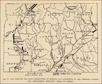
| Plate IV. A. Old limestone quarry, 3 ½ miles south of Perry, Houston County. |  |


Commercial use of material within this site is strictly prohibited. It is not to be captured, reworked, and placed inside another web site ©. All rights reserved. Peggy B. and George (Pat) Perazzo.