
List
of Quarries in Georgia & Quarry Links,
Photographs and Articles
(The following list of Georgia quarries is not a complete list of all of the historical quarries in the state, only the ones I have been able to locate. If you know of more historical quarries in Georgia, please contact me. Peggy B. Perazzo)
- Georgia Quarries (present-day companies), presented by superpages.com.
- Map Showing the Distribution of the Granites
and Gneisses of Georgia, from A Preliminary Report
on a Part of the Granites and Gneisses of Georgia, Bulletin No.
9-A, by Thomas L. Watson, Ph.D., Assistant Geologist, Geological Survey
of Georgia, 1902, pp. 88.
Map Showing the Distribution of the Granites and Gneisses of Georgia, by Thomas L. Watson, Assistant Geologist, 1901, Geological Survey of Georgia, W. S. Yeates, State Geologist (circa 1901). 
- Georgia – Map of Georgia Showing Distribution of Granite Areas
and Location of Granite Quarries (circa 1902). (From Granites
of the Southeastern Atlantic States, Bulletin 426, 1910. Based
on map of Georgia
Geological Survey, Bulletin 9-A, 1902. Plate XXIV.)
Map of Georgia Showing Distribution of Granite Areas and Location of Granite Quarries (circa 1902/1910) 
-
Northwest, Georgia – Map Showing the Distribution of Marble in Northwest Georgia (circa 1907), from A Preliminary Report on the Marbles of Georgia, Bulletin No. 1, by S. W. McCallie, Assistant State Geologist, Geological Survey of Georgia, 2nd ed., 1907, pp. 34. (This book is available on Google Books – Full View Books.)
Map Showing the Distribution of Marble in Northwest Georgia, 1905, by S.W. McCallie, Assistant Geologist,Geological Survey of Georgia, W.S. Yeates, State Geologist, 1907. 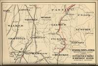
- Index Map Showing the Distribution of Slate-bearing
Formations in Georgia (circa 1918), from Report on The
Slate Deposits of Georgia, Bulletin No. 34, by H. K. Shearer,
Assistant State Geologist, Geological Survey of Georgia, 1918, pp.
42.
Map I. Index map showing the distribution of slate-bearing formations in Georgia (circa 1918) 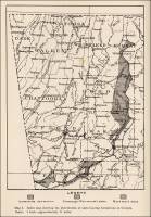
- Map – Geological Outline Map of Georgia (circa
1902), from A Preliminary Report on a Part of the Granites
and Gneisses of Georgia, Bulletin No. 9-A, by Thomas
L. Watson, Ph.D., Assistant Geologist, Geological Survey of Georgia,
1902, pp. 64.
Geological Outline Map of Georgia, Geological Survey of Georgia, W. S. Yeates, State Geologist. 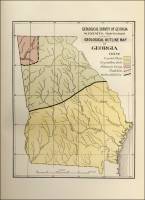
- Georgia – Map Showing the Physiologic Subdivisions of
Georgia, from A Preliminary Report on a Part of the Granites
and Gneisses of Georgia, Bulletin No. 9-A, by Thomas L. Watson,
Ph.D., Assistant Geologist, Geological Survey of Georgia, 1902, pp.
74.
Map Showing the Physiographic Subdivisions of Georgia, by Thomas L. Watson, Assistant Geologist, 1901, Geological Survey of Georgia, W. S. Yeates, State Geologist. 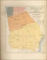
-
Georgia – Map Showing the Physiographic Subdivisions of Georgia (circa 1912), from A Report on the Limestones and Cement Materials of North Georgia, Bulletin No. 27, by T. Poole Maynard, Ph.D., Assistant State Geologist, Geological Survey of Georgia, 1912, pp. 76.
Fig. 2. Map Showing the Physiographic subdivisions of Georgia (circa 1912) 
- Georgia – Map Showing the Granite Localities Described – Near
Appling, near Camak, Coweta Station, Elberton, Greenville,
Lexington, Lithonia, near Newnan, and near Oglesby from A
Preliminary Report on a Part of the Granites and Gneisses of Georgia,
Bulletin No. 9-A, by Thomas L. Watson, Ph.D., Assistant Geologist,
Geological Survey of Georgia, 1902, pp. 80.
Map Showing the Granite Localities Described: Near Appling, near Camak, Coweta Station, Elberton, Greenville, Lexington, Lithonia, near Newnan, and near Oglesby. 
- Georgia – Map of the
DeKalb-Rockdale-Gwinnett Granite and Granite-Gneiss Area,
from A Preliminary Report on a Part of the Granites and Gneisses
of Georgia, Bulletin No. 9-A, by Thomas L. Watson, Ph.D., Assistant
Geologist, Geological Survey of Georgia, 1902, pp. 112.
Map of the DeKalb-Rockdale Granite and Granite-gneiss Area. 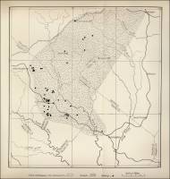
- Georgia – Map of the
Oglethorpe-Madison-Elbert Granite Area (Granite), from A
Preliminary Report on a Part of the Granites and Gneisses of Georgia,
Bulletin No. 9-A, by Thomas L. Watson, Ph.D., Assistant Geologist,
Geological Survey of Georgia, 1902, pp. 200.
Map of the Oglethorpe-Madison-Elbert Granite Area, Georgia. 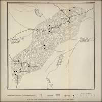
- Piedmont, Georgia - Map of Piedmont Georgia Showing
Areas of Porphyritic Granite
(From Granites of the Southeastern Atlantic
States, Bulletin 426, 1910)
fig. 20. Map of Piedmont Georgia showing areas of porphyritic granite 
- Stone Mountain, Georgia - Map of Stone Mountain and Lithonia-Conyers-Lawrenceville
Granite and Gneiss Area, Georgia (From Granites
of the Southeastern Atlantic States, Bulletin 426, 1910)
fig. 19. Map of Stone Mountain and Lithonia-Conyers-Lawrenceville Granite and Gneiss Area, Georgia 
-
Central Upland, Georgia – Topographic Divisions of the Central Upland of Georgia (Map), from Geology of the Tate Quadrangle, Georgia, Bulletin No. 43, by W. S. Bayley, University of Illinois, Geological Survey of Georgia, Atlanta, 1928, pp. 3.
Fig. 1. The Topographic Divisions of the Central Upland of Georgia. Small rectangle shows the location of the Tate Quadrangle. 


Commercial use of material within this site is strictly prohibited. It is not to be captured, reworked, and placed inside another web site ©. All rights reserved. Peggy B. and George (Pat) Perazzo.