- Georgia Department of Natural Resources
- Georgia Geologic Survey Maps and Publications, 19 M. L. King Jr. Drive, SW, 4th Floor (Agriculture Building), Atlanta GA 30334, (404) 656-3214.
- Miscellaneous Information including information on the past issues of The Georgia Mineral Newsletter (January, 1948 to vol. XVII, November, 1964-1965), historical maps, information on their library holdings, etc
- “Age and Origin of the Stone Mountain Granite, Lithonia District, Georgia,” by James A. Whitney, Lois M. Jones, and Raymond L. Walker Geological Society of America Bulletin: Vol. 87, No. 7, pp. 1067–1077.
- DiscoverySchool.com (Worldbook) Georgia Minerals and Mining. Along the southern edge of the Piedmont lie large deposits of granite. Georgia ranks first in granite production. In the north-central and northeastern parts of the state crushed granite is produced. In northeastern Georgia, mainly in Elbert County, building granite is quarried. Limestone is also quarried in Georgia. (This information is no longer available on this web site.)
<http://school.discovery.com/homeworkhelp/worldbook/atozgeography/g/221760.html>
- Geologic Features of Eastern Pickens, Dawson, and Western Lumpkin Counties, Georgia, edited by John O. Costello, 37th Annual Field Trip, Georgia Geological Society, October 12, and 13, 2002, Georgia Geological Society Guidebooks, Vol. 22, No. 1, October 2002. (PDF)
- Geology of Stone Mountain, Georgia, by Pamela J. W. Gore.
- Georgia Geology, by Chuck Cochran. The Murphy Marble Belt extends from "near Murphy, North Carolina, into north central Georgia."
- The Geology of Georgia, presented by University of Georgia, Department of Geology.
- Georgia – Geological Outline Map of Georgia (circa 1902), from A Preliminary Report on a Part of the Granites and Gneisses of Georgia, Bullet No. 9-A, by Thomas L. Watson, Ph.D., Assistant Geologist, Geological Survey of Georgia, 1902, pp. 64.
| Geological Outline Map of Georgia, Geological Survey of Georgia, W. S. Yeates, State Geologist |
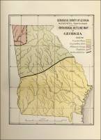 |
- Georgia - Map Showing the Physiologic Subdivisions of Georgia (circa 1901), from A Preliminary Report on a Part of the Granites and Gneisses of Georgia, Bulletin No. 9-A, by Thomas L. Watson, Ph.D., Assistant Geologist, Geological Survey of Georgia, 1902, pp. 74.
| Map Showing the Physiographic Subdivisions of Georgia, by Thomas L. Watson, Assistant Geologist, 1901, Geological Survey of Georgia, W. S. Yeates, State Geologist. |
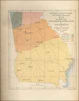 |
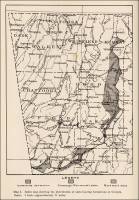
- Georgia - Map Showing the Physiographic Subdivisions of Georgia (circa 1912), from A Report on the Limestones and Cement Materials of North Georgia, Bulletin No. 27, by T. Poole Maynard, Ph.D., Assistant State Geologist, Geological Survey of Georgia, 1912, pp. 76.
| Fig. 2. Map Showing the Physiographic subdivisions of Georgia (circa 1912) |
 |
- Georgia - Map Showing the Distribution of the Granites and Gneisses of Georgia, from A Preliminary Report on a Part of the Granites and Gneisses of Georgia, Bulletin No. 9-A, by Thomas L. Watson, Ph.D., Assistant Geologist, Geological Survey of Georgia, 1902, pp. 88.
| Map Showing the Distribution of the Granites and Gneisses of Georgia, by Thomas L. Watson, Assistant Geologist, 1901, Geological Survey of Georgia, W. S. Yeates, State Geologist. |
 |
- Northwest, Georgia – Map Showing the Distribution of Marble in Northwest Georgia (circa 1907), from A Preliminary Report on the Marbles of Georgia, Bulletin No. 1, by S. W. McCallie, Assistant State Geologist, Geological Survey of Georgia, 2nd ed., 1907, pp. 34.
| Map Showing the Distribution of Marble in Northwest Georgia, 1905, by S.W. McCallie, Assistant Geologist,Geological Survey of Georgia, W.S. Yeates, State Geologist, 1907. |
 |
- Georgia - Index Map Showing the Distribution of Slate-bearing Formations in Georgia (circa 1918), from Report on The Slate Deposits of Georgia, Bulletin No. 34, by H. K. Shearer, Assistant State Geologist, Geological Survey of Georgia, 1918, pp. 42.
| Map I. Index map showing the distribution of slate-bearing formations in Georgia (circa 1918) |
 |
- Central Upland, Georgia – Topographic Divisions of the Central Upland of Georgia (Map), from Geology of the Tate Quadrangle, Georgia, Bulletin No. 43, by W. S. Bayley, University of Illinois, Geological Survey of Georgia, Atlanta, 1928, pp. 3.
| Fig. 1. The Topographic Divisions of the Central Upland of Georgia. Small rectangle shows the location of the Tate Quadrangle. |
 |
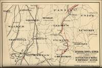
- Georgia - Map of the Piedmont Plateau & Appalachian Mountain Areas of Georgia – Distribution of Marbles and Limestones (circa 1912), from A Report on the Limestones and Cement Materials of North Georgia, Bulletin No. 27, by T. Poole Maynard, Ph.D., Assistant State Geologist, Geological Survey of Georgia, 1912, pp. 81.
| Fig. 3. Map showing the areal distribution of marbles and limestones in the Piedmont Plateau and Appalachian Mountain areas of Georgia (circa 1912) |
 |
- Georgia - Table of Geological Formations of the Appalachian Valley and Cumberland Plateau Areas of Georgia, from Report on The Slate Deposits of Georgia, Bulletin No. 34, by H. K. Shearer, Assistant State Geologist, Geological Survey of Georgia, 1918, pp. 46.
| Table of Geological Formation of the Appalachian Valley and Cumberland Plateau Area of Georgia (circa 1918) |
 |
- Georgia State Minerals Information (USGS)
- Granite Outcrops in Georgia, presented by the New Georgia Encyclopedia.
- Bluff Creek, Georgia – View looking southwest up Bluff Creek near junction with Corinth Church (Graywacke & Mica Schists), from Geology of the Tate Quadrangle, Georgia, Bulletin No. 43, by W. S. Bayley, University of Illinois, Geological Survey of Georgia, Atlanta, 1928, pp. 56.
| Plate VI. B. View looking southwest up Bluff Creek near junction with Sharp Mountain Creek, showing layers of graywacke and mica schists of the Great Smoky Formation. |
 |
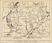
- Boynton to Peavine Ridge, Georgia – Outcrop of the Conasauga Formation (from Geology and Mineral Resources of the Paleozoic Area in Northwest Georgia, Bulletin No. 54, by Charles Butts, Geologist, U.S.G.S. (retired) and Benjamin Gildersleeve, Geologist, TVA, Georgia State Division of Conservation, Published in cooperation with the Tennessee Valley Authority, Atlanta, 1948, pp. 6
| Fig. 2. Looking southeast over Peavine Valley from a point on Boynton Ridge, one mile northwest of Boynton to Peavine Ridge on the outcrop of the Conasauga formation and representative of all such valleys in northwest Georgia. |
 |
-
Central Upland, Georgia – Topographic
Divisions of the Central Upland of Georgia (Map) ,
from Geology of the Tate Quadrangle, Georgia, Bulletin
No. 43, by W. S. Bayley, University of Illinois, Geological
Survey of Georgia, Atlanta, 1928, pp. 3.
| Fig. 1. The Topographic Divisions
of the Central Upland of Georgia.
Small rectangle shows the location of the Tate Quadrangle. |
|
- Chickamauga, Walker County, Georgia – Knox Dolomite
Topography (Dolomite) (from Geology and Mineral Resources of the Paleozoic Area in Northwest Georgia, Bulletin No. 54, by Charles Butts, Geologist, U.S.G.S. (retired) and Benjamin Gildersleeve, Geologist, TVA, Georgia State Division of Conservation, Published in cooperation with the Tennessee Valley Authority, Atlanta, 1948, pp. 6.
| Fig. 1. Knox dolomite topography, looking northeast from a point about three miles southwest of Chickamauga, Walker County. |
 |
- Corinth Church (near), Georgia – View of Channel, East Fork of Long Swamp Creek, near Corinth (Graywacke), from Geology of the Tate Quadrangle, Georgia, Bulletin No. 43, by W. S. Bayley, University of Illinois, Geological Survey of Georgia, Atlanta, 1928, pp. 56.
| Plate VI. A. View of Channel, east fork of Long Swamp Creek, near Corinth Church. Bedrock is Carolina graywacke. |
 |
-
Dewitt Ferry (above), Mitchell County,
Georgia – Flint & Limestone Exposure (from A
Report on the Limestones and Marls of the Coastal Plain of Georgia,
Bulletin 21, 1910, by J. E. Brantly, Assistant State Geologist,
Geological Survey of Georgia, Atlanta, GA: The Blosser Co.,
1916, pp. 240)
| Plate X. A. Exposure of flint
and limestone of the Jackson Group just above Dewitt
Ferry, Flint River, Mitchell County. |
 |
-
Flint River, Crisp County, Georgia – Limestone
Bluff on the Armstrong Property (from A Report
on the Limestones and Marls of the Coastal Plain of Georgia,
Bulletin 21, 1910, by J. E. Brantly, Assistant State Geologist,
Geological Survey of Georgia, Atlanta, GA: The Blosser Co.,
1916, pp. 176)
| Plate VIII. B. Limestone bluff
on Armstrong property, Flint River,
Crisp County. |
 |
- Four Mile Creek (near), Pickens County, Georgia – Exposure
of Carolina Gneiss in cut on the Abandoned Ball Ground-Marble
Hill Railroad (Carolina Gneiss), from Geology of the Tate Quadrangle, Georgia, Bulletin No. 43, by W. S. Bayley, University of Illinois, Geological Survey of Georgia, Atlanta, 1928, pp. 16.
| Plate IV. Exposure of Carolina Gneiss in cut on the old abandoned Ball Ground-Marble Hill Railroad, near Four Mile Creek, Pickens County, Georgia. |
 |
-
Hawkinsville, Pulaski County, Georgia – Limestone
Exposure (from A Report on the Limestones and Marls
of the Coastal Plain of Georgia, Bulletin 21, 1910, by
J. E. Brantly, Assistant State Geologist, Geological Survey
of Georgia, Atlanta, GA: The Blosser Co., 1916, pp. 176)
| Plate VIII. A. Limestone exposure,
west bank of Ocmulgee River,
1 ¾ miles below Hawkinsville, Pulaski
County. |
 |
- Heggie’s
Rock, located in Columbia County, near Appling, presented by the Nature Conservancy. “Nestled in a forest of pines and hardwoods, this outcrop of coarse-grained granite towers nearly 70 feet over the surrounding area. Known
as Heggie's Rock for the last 150 years, this monolith is one
of the most striking examples of granite flatrock in Georgia.”
- Jasper (southwest of), Pickens County, Georgia – Open Cut showing Sericite Schist (Sericite Schist), from Geology of the Tate Quadrangle, Georgia, Bulletin No. 43, by W. S. Bayley, University of Illinois, Geological Survey of Georgia, Atlanta, 1928, pp. 60.
| Plate VII. B. Open cut showing sericite schist. Lot 120, 13th District, Pickens County, 4 miles southwest of Jasper, Georgia. |
 |
-
Kathleen (east of), Houston County,
Georgia – Limestone & Fullers Earth
Outcrop (from A Report on the Limestones and Marls
of the Coastal Plain of Georgia, Bulletin 21, 1910, by
J. E. Brantly, Assistant State Geologist, Geological Survey
of Georgia, Atlanta, GA: The Blosser Co., 1916, pp. 80)
| Plate V. A. Limestone and
fullers earth outcrop on small property, 4 ½ miles
east of Kathleen, Houston County. |
 |
-
Kathleen, Houston County, Georgia – Limestone
Ridge (from A Report on the Limestones and Marls
of the Coastal Plain of Georgia, Bulletin 21, 1910, by
J. E. Brantly, Assistant State Geologist, Geological Survey
of Georgia, Atlanta, GA: The Blosser Co., 1916, pp. 112)
| Plate VI. A. Limestone ridge
on small property, 4 ½ miles east of Kathleen,
Houston County. |
 |
-
Kinchafoonee (east side of), Lee County,
Georgia – Limestone Bluff (from A
Report on the Limestones and Marls of the Coastal Plain of Georgia,
Bulletin 21, 1910, by J. E. Brantly, Assistant State Geologist,
Geological Survey of Georgia, Atlanta, GA: The Blosser Co.,
1916, pp. 208)
| Plate IX. A. Limestone bluff,
east side Kinchafoonee Creek, Lee County. |
 |
| Plate IX. B. Limestone Bluff,
east side Kinchafoonee Creek, Lee County. |
 |
- Kyanite Crystals & Kyanite Mica Schist (Kyanite), from Geology of the Tate Quadrangle, Georgia, Bulletin No. 43, by W. S. Bayley, University of Illinois, Geological Survey of Georgia, Atlanta, 1928, pp. 70.
| Plate VIII. A. Kyanite crystals (blades) in quartz vein, one-third natural size. |
 |
| Plate VIII. B. Weathered surface of kyanite mica schist. The ridges are altered kyanite prisms. One-half natural size. |
 |
- A Location Guide for Rockhounds, (PDF) Collected by Robert C. Beste, PG, St. Louis, Missouri: Hobbitt Press, 2nd ed., December 1996, 148 pp. (Includes chapters on “Mineral Locations by State,” “Appendix and Glossary,” and “Bibliography.”)
- Long Swamp Creek, Georgia – Carolina Gneiss (Gneiss/Schist), from Geology of the Tate Quadrangle, Georgia, Bulletin No. 43, by W. S. Bayley, University of Illinois, Geological Survey of Georgia, Atlanta, 1928, pp. 122.
| Plate X. A. Curved fault in Carolina gneiss on road between Long Swamp Creek and Cherry Gove School, about one-half mile northeast of bridge over Long Swamp Creek. View looking north. The dip of the schist is about 50° Northeast. |
 |
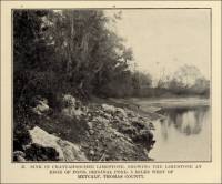
-
Metcalf, Thomas County, Georgia – Sink
in Chattahoochee Limestone (from A Report on the
Limestones and Marls of the Coastal Plain of Georgia, Bulletin
21, 1910, by J. E. Brantly, Assistant State Geologist, Geological
Survey of Georgia, Atlanta, GA: The Blosser Co., 1916, pp. 240)
| Plate X. B. Sink in Chattahoochee Limestone,
showing the limestone at edge of pond, Original Pond,
3 miles west of Metcalf, Thomas County. |
 |
- The Murphy Marble Belt,
presented by Chuck Cochran - The Murphy Marble Belt extends from “near
Murphy, North Carolina, into north central Georgia.”
- North Georgia Mountains Longstreet Highroad Guide to the North Georgia Mountains, by the Georgia Conservancy. This site is presented by Sherpa Guides.
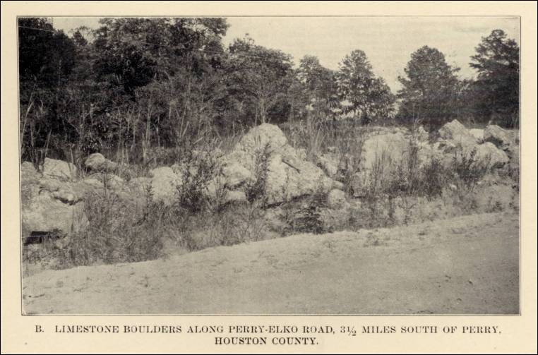
-
Perry (south of), Houston County, Georgia – Limestone
Boulders along Perry-Elko Road (from A Report on
the Limestones and Marls of the Coastal Plain of Georgia,
Bulletin 21, 1910, by J. E. Brantly, Assistant State Geologist,
Geological Survey of Georgia, Atlanta, GA: The Blosser Co.,
1916, pp. 80)
| Plate V. B. Limestone boulders
along Perry-Elko Road,
3 ½ miles south of Perry, Houston County. |
 |
-
Perry (south of), Houston County, Georgia – Limestone
Exposure on Mossy Ridge (from A Report on the Limestones
and Marls of the Coastal Plain of Georgia, Bulletin 21,
1910, by J. E. Brantly, Assistant State Geologist, Geological
Survey of Georgia, Atlanta, GA: The Blosser Co., 1916, pp. 64)
| Plate IV. B. Limestone exposure
on Mossy Ridge, 5 miles south of Perry, Houston
County. |
 |
- Pine Mountain, Lithonia, Georgia – Pine Mountain, from A Preliminary Report on a Part of the Granites and Gneisses of Georgia, Bullet No. 9-A, by Thomas L. Watson, Ph.D., Assistant Geologist, Geological Survey of Georgia, 1902, pp. 152.
| Plate XIII. A view of Pine Mountain, Lithonia, Georgia, an unreduced residual of granite-gneiss, from a point of view, a quarter of a mile away. |
 |
- Porter’s Landing, Effingham County, Georgia – Exposure of Miocene Marls and Clays (from A Preliminary Report on the Mineral Resources of Georgia, Bulletin No. 23, by S. W. McCallie, State Geologist, Geological Survey of Georgia, Atlanta: 1910, pp. 144)
| Plate XV. Exposure of Miocene marls and clays, Porter’s Landing, Effingham County, Georgia. |
 |
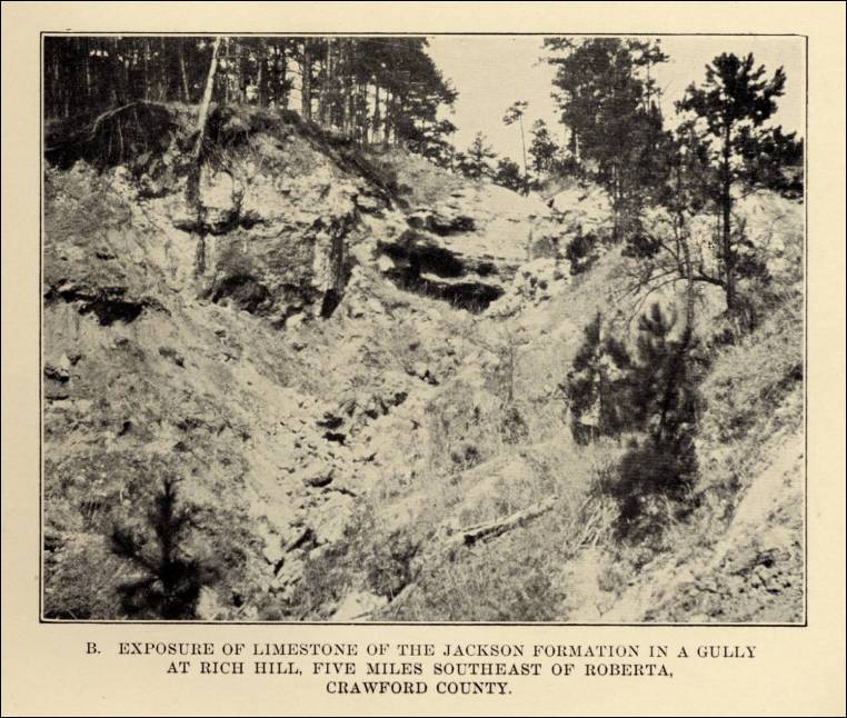
-
Rich Hill, Crawford County, Georgia – Limestone
Exposure (from A Report on the Limestones and Marls
of the Coastal Plain of Georgia, Bulletin 21, 1910, by
J. E. Brantly, Assistant State Geologist, Geological Survey
of Georgia, Atlanta, GA: The Blosser Co., 1916, pp. 32)
| Plate II. B. Exposure of limestone
of the Jackson Formation in a gully at Rich Hill, five
miles southeast of Roberta, Crawford County. |
 |
- Roberts Lake, Georgia – Roberts Lake on Long Swamp
Creek, East of Ball Ground (Carolina Gneiss), from Geology of the Tate Quadrangle, Georgia, Bulletin No. 43, by W. S. Bayley, University of Illinois, Geological Survey of Georgia, Atlanta, 1928, pp. 14.
| Plate III. A. Roberts Lake on Long Swamp Creek East of Ball round, showing characteristic topography near water courses in the Carolina Gneiss. |
 |
- Rudicil Mill (near), Georgia – Contorted Pegmatite & Quartz Veins in Carolina Graywacke & Schists (Graywacke & Schists), from Geology of the Tate Quadrangle, Georgia, Bulletin No. 43, by W. S. Bayley, University of Illinois, Geological Survey of Georgia, Atlanta, 1928, pp. 60.
| Plate VII. B. Contorted pegmatite and quartz veins in Carolina graywacke and schists, near Rudicil Mill, 4 miles south of Orange, in the neighboring quadrangle. |
|
- Sharp Mountain, Pickens County, Georgia – Near View of Sharp Top Mountain, from Geology of the Tate Quadrangle, Georgia, Bulletin No. 43, by W. S. Bayley, University of Illinois, Geological Survey of Georgia, Atlanta, 1928, pp. 14.
| Plate III. B. Near view of Sharp Top Mountain situated a short distance beyond the northern boundary of the Tate Quadrangle. |
 |
-
Shell Bluff, Burke County, Georgia – Ostrea
Georgiana Bed (from A Report on the Limestones
and Marls of the Coastal Plain of Georgia, Bulletin 21,
1910, by J. E. Brantly, Assistant State Geologist, Geological
Survey of Georgia, Atlanta, GA: The Blosser Co., 1916, pp.
32)
| Plate II. A. Ostrea Georgiana Bed
at Shell Bluff, Savannah River, Burke, County. |
 |
- Staurolite-Kyanite Schist & Canton Schist, from Geology of the Tate Quadrangle, Georgia, Bulletin No. 43, by W. S. Bayley, University of Illinois, Geological Survey of Georgia, Atlanta, 1928, pp. 44.
| Plate V. A. Staurolite-Kyanite Schist. |
 |
| Plate V.A. Canton Schist. |
 |
- Stone Mountain, Georgia - Virtual Field Trip, presented by Pamela J. W. Gore, Georgia Perimeter College.
-
Tivola (south of), Houston County, Georgia – Limestone
Exposure (from A Report on the Limestones and Marls
of the Coastal Plain of Georgia, Bulletin 21, 1910, by
J. E. Brantly, Assistant State Geologist, Geological Survey
of Georgia, Atlanta, GA: The Blosser Co., 1916, pp. 48)
| Plate III. A. Limestone exposure
on G.S. & F. R.R. south of Tivola, Houston County. |
 |
- William Weinman Mineral Museum, Cartersville, Bartow County, Georgia.
Commercial use of material within this site is strictly prohibited. It
is not to be captured, reworked, and placed inside another web site. ©
. All rights reserved. Peggy
B. and George (Pat)
Perazzo.