
Yolo County
- Yolo County – List of Stone Quarries, Etc.
-
Some Stone Carvers & Monument Companies that Produced the Yolo County Cemetery Stones in the late 1800s-early 1900s, & Some California Stone Quarries, by Peggy B. Perazzo, used David Wilkinson’s “Stones of Woodland” tour during the annual Stroll Through History in September in Woodland, Yolo County, California.
- Yolo County Mines and Minerals (circa 1870) – Excerpts from The Western Shore Gazetteer and Commercial Directory, For the State of California…, Yolo County, compiled and published annually by C. P. Sprague & H. W. Atwell, Woodland, Yolo County, 1870.
- Yolo County circa 1890 – Excerpts from Tenth Annual Report of the State Mineralogist, For the Year Ending December 1, 1890, California State Mining Bureau, Sacramento, 1890.
- Yolo County Sandstone, and Tuffs (historical times through circa 1906) – Excerpts from The Structural and Industrial Materials of California, Bulletin No. 38, California, State Mining Bureau, San Francisco, California, 1906.
- Yolo County Mineral Production for 1913 – Excerpt from Mineral Production for 1913, Bulletin No. 68, California State Mining Bureau, Sacramento, 1914.
- Yolo County Mines and Mineral Resources (circa 1913-1914) – Excerpts from Report XIV of the State Mineralogist – Mines and Mineral Resources of Portions of California, Chapters of State Mineralogist’s Report – Biennial Period 1913-1914, Part II. “The Counties of Colusa, Glenn, Lake, Marin, Napa, Solano, Sonoma, Yolo,” by Walter W. Bradley, Field Assistant (field work in September, 1913), San Francisco, California, July, 1915, 1916.
- Yolo, County, California, Mineral Resources & Introduction to the Yolo County Area of California (circa 1915) – Excerpt from Sacramento Valley and Foothill Counties of California: An Illustrated Description of all the Counties Embraced in this Richly productive Geographical Subdivision of the Golden State, compiled and edited by Emmett Phillips and John H. Miller, Published under the direction of The Sacramento Valley Exposition, J. A. Filcher, Director-in Chief, January 1915.
- Yolo County Mineral Industry (circa 1919) – Excerpt from California Mineral Production for 1919, Bulletin No. 88, by Walter W. Bradley, California State Mining Bureau, 1920.
- Yolo County Mining During 1920 – Excerpt from Report XVII of the State Mineralogist: Mining in California During 1920, California State Mining Bureau, Sacramento, 1921.
- Yolo County Limestone Deposits (through 1947) – Excerpts from “Limestone in California,” by Clarence A. Logan, California Journal of Mines and Geology, Vol. 43, No. 3, July 1947, California Division of Mines, San Francisco, California.
- Yolo County Mines and Mineral Resources (circa 1950) – Excerpts from “Mines and Mineral Resources of Yolo County,” in California Journal of Mines and Geology, Vol. 46, No. 3, July 1950, State of California Department of Natural Resources, Division of Mines.
- Yolo County Historical Resources presented on the Yolo County CAGenWeb Project web site during the time the site was hosted by Peggy B. Perazzo, Compiler, and Patrick Perazzo, Webmaster (1997-2012). (Please note, the Yolo County CAGenWeb Project web site is currently hosted by another host, and may no longer appear as it does in the version at the above link. The material you will view using the above Internet Archive Wayback Machine link was updated through 2012 when Peggy B. Perazzo withdrew as host of the web site. The historical material contributed by Peggy B. Perazzo is still available at the Internet Archive Wayback Machine link above.)
- Yolo County Mines and Minerals (circa 1870) – Excerpts from The Western Shore Gazetteer and Commercial Directory, For the State of California…, Yolo County, compiled and published annually by C. P. Sprague & H. W. Atwell, Woodland, Yolo County, 1870, pp. 111-112.
Mines and Minerals (in Yolo County).
“The mining interest is but lightly represented in this county, with one exception. But little prospecting for the precious metals has been attempted, though ‘indications’ of the existence of various kinds of mineral are not wanting in the foothills and mountain ranges that form the western boundary of the county. Gold, copper, sulphur, lead and cinnabar indications are frequently found, such as would justify extended prospecting in a country where the attention of the inhabitants was directed to mining instead of agriculture.
Gold Mining (in Yolo County).
“Has been carried on, to some extent, on Putah Creek and in some gulches and ravines in the foothills near Cache Creek Cañon. Absence of water, inexperience of mining matters, and the all-absorbing interests of agriculture, may be given as sufficient reasons why this branch of industry has received no more attention. That gold exists in the first range of hills is a fact; but whether in quantities sufficient to justify any great outlay of capital in the prospecting or working of the ground, remains to be decided. Copper ‘signs’ are plenty in the hills, and occasionally one meets with indications of coal and iron. The formation of the ranges, their volcanic origin, and the undisputed fact of the existence of gold and cinnabar, would warrant a more extended and thorough examination of the county than has ever been given to it.
Cinnabar (in Yolo County).
“In the extreme northwestern portion of the county is located the cinnabar or quicksilver mines of Charles F. Reed & Co., known as the California Mines. This company are pushing the work on their mine, with every assurance of success. The mine lies but a few (six) miles from the celebrated Knoxville and Manhattan cinnabar mines, and is evidently a continuation of the belt which traverses a section of Lake and Yolo counties. This cinnabar-bearing belt extends from Oregon southward through the Coast Range; how far is not definitely ascertained, but either the mineral or indications have been discovered at intervals through the whole extent of the Coast Range from Oregon to Mexico.
“In the district where Reed’s mine is located, very rich deposits of cinnabar have been found and two large mines, with furnaces and machinery attached, employing about three hundred men and turning out from four hundred to one thousand flasks of quicksilver per week when the furnaces are in operation. These mines are located in Lake County, the dividing line between Lake and Yolo passing between these mines and that owned by Reed & Co. The surrounding hills are thickly studded with ‘indications’ and ‘croppings’ which reveal the existence of cinnabar-bearing lodes….”
- Yolo County circa 1890 - Excerpts from Tenth
Annual Report of the State Mineralogist, For the Year Ending
December 1, 1890, California State Mining Bureau, Sacramento:
State Printing 1890, pp. 773-794. (This book is available for
reading or downloading to your computer on Google
Book Search - Full View Books.)
Yolo County
By W. L. Watts, Assistant in the Field.
“Yolo is essentially an agricultural county, and by far the greater portion of its area is devoted to the growth of cereal crops. The surface soil throughout is principally a clayey loam, varying in places to sand or adobe, accordingly as the streams, which have influenced its quality, having borne an excess of either sandy or aluminous material from the neighboring mountains. Close to the western foothills the soil becomes frequently of a more gravelly nature, while upon the eastern side of the county, throughout the ‘tule’ lands, which form the approach to the Sacramento River, the soil is more clayey, and usually gives place to ‘adobe.’
“Immediately along the western bank of the Sacramento there is a strip of land, averaging from half a mile to a mile in width, the superficial strata of which are formed of sedimentary deposits from the river. This land is remarkable for its fertility and facility of cultivation. There is also a large area in the eastern portion of the county, which is subject to overflow every two or three years by the Sacramento River, which leaves behind a deposit of very fertile soil.
“The county is traversed by two principal creeks, which rising in the mountains to westward, flow down toward the Sacramento River. These are Cache Creek, which is discharged from Clear Lake in Lake County, and the Putah Creek, which takes its rise in the mountains of Napa, and on part of its course forms the southern boundary of the county. Although these creeks, especially Putah Creek, show considerable volume where they first enter the county, for the greater part of the year their waters dwindle away and disappear before reaching the Sacramento.
“Both Cache and Putah Creeks are torrents during the winter months, cutting their way through cañons before reaching the Sacramento Valley, strewing their beds with waterworn rocks and cobbles, and showing on the cañons’ sides the effects of the violent winter floods. As these streams debouch into the valley at Capay and a few miles west of Winters, respectively, the grade lessens. The Putah Creek enters the valley from amid rolling hills, and the formations of shale, sandstone, and conglomerate in the neighborhood of Winters give place to clay and sand. At Capay, where Cache Creek enters the valley, its banks are composed of clay and gravelly strata; from here it flows through a flat country sloping gradually to the southeast. A short distance east of Capay the creek widens, and its banks are only four or five feet high, while lower down towards Madison bridge the stream is again confined between higher banks. The shifting waters of these streams have formed a bed of sand banks. The shifting waters of these streams have formed a bed of sand and gravel throughout the intervening country, which is now covered with soil. This gravel forms a water plane, which appears to slope to the southeast with a grade of about two and a half times that of the surface. This gravel, no doubt, received contributions from various smaller streams, which, fed by the excessive rainfall of Post Glacial periods, washed out the smaller valleys, and thus assisted in molding the mountains to their present form, and distributing the waterworn debris upon the surface of the clays in the valleys below. The former channels of these streams are now either covered with alluvial soil, or their courses through the plain are marked by arroyos, destitute of water except after long rains; all evidence of their existence, other than the gravels they formed, are being rapidly obliterated by the plowshare and pluvial erosion.
“The extreme western borders of the county are occupied by a portion of the Coast Range, while a tongue of rolling hills, which commences a few miles to the northeast of Cacheville, extends with broadening radius toward the northwest corner of the county.
“Between these hills is a large valley, called Hungry Hollow, which is devoted to the growing of wheat and to stock raising; while between Putah and Cache Creeks the land gradually slopes from the Coast Range to the Sacramento River.
“Although the minerals in the mountains on the western side of the county are not to be overlooked, and the geological features influencing the character of the soil require attention at the hands of the Mining Bureau, still the hydrographical features are of such supreme importance that we commence a wider field of geological inquiry, by collecting and placing in tangible form the scattered records and observations that have been made concerning the water and the formation in which a subterranean supply of that invaluable fluid has been obtained in different parts of the county....”
Building Stone.
“The only quarry that is worked to any extent in Yolo County is situated at the Devil’s Gate, in Putah Cañon, about nine miles west of Winters, on the north side of Putah Creek. The formation in which the quarry has been opened appears to extend from a southeasterly to a northwesterly direction. The stone is a compact sandstone of various shades of blue and gray; it is of smooth grain, and occasionally shows particles of carbonaceous matter. Where the rock has been quarried, near the road at Devil’s Gate, it appears to be free from pebbles. It splits with a true fracture, and slabs fourteen feet by sixteen inches by ten inches have frequently been taken out. This stone has been used for many years for cemetery and building work, and it appears to wear well. It is said that it was originally intended to build the Capitol at Sacramento of this stone. The strata exposed at the Devil’s Gate quarry are, many of them, twelve or fifteen feet in thickness, and dip to the northeast at an angle of about 65 degrees. In the part of the cañon where the quarry is situated, the Putah Creek has cut through the upturned strata almost at right angles with the formation. In T. 8 N., R. 2 W., M.D.M., a ledge of aragonite similar to the Suisun marble is said to have been discovered.
“A volcanic tuff occurs abundantly in the eastern margin of the foothills to the west of Winters, and in places affords a fair building material. It is a soft, whitish rock, which becomes hard on exposure to the air.
“The residence of J.R. Wolfskill was built of this stone about twenty-five year ago, and appears to stand the weather remarkably well; several other building in winters are built of similar material.
“A sandstone suitable for building purposes is also said to occur on the ranch of E. Gordon, about eight miles north of the Vacaville and Clear Lake Railroad.”
Yolo County.
By W. A. Goodyear, Geologist, and Assistant in the Field.
“The village of Winters is in Yolo County, being on the left bank of Puta (sic) Creek, which for a considerable distance here forms the boundary between Yolo and Solano Counties.
“In the mountains about seven miles up the creek from Winters there is on the left bank of the creek a quarry of yellowish brown sandstone, moderately hard, with pretty uniform and rather fine grain, which has been used to some extent for building purposes and for fence posts and monuments in the cemetery. At the quarry it strikes about north 30 degrees west magnetic and dips about 70 degrees northeast, and is very heavy bedded. It can be obtained in very large blocks, if desired, and its quantity is inexhaustible.
“A mile or two below this quarry, and also on the left bank of the creek, there is a considerable area strewn with very black basalt, which shows in the form of apparently loose but often enormous blocks or bowlders, many of which are several hundred tons in weight; and in many of these huge blocks there are rudely developed columnar forms. This basalt does not appear to cross the creek, though it comes down to its bed.
“There are several sulphur springs in the neighborhood, and at one point a little ways below the sandstone quarry there is a small deposit of calcareous tufa.
“A short distance below the basaltic area, and also on the left bank of the creek, the road passes for some distance over a quite extensive deposit of consolidated volcanic ash, some of which is very thinly bedded, and which, though lying nearly horizontal, nevertheless dips very gently towards the southeast.”
- Yolo County Sandstone and Tuffs (historical times through / circa 1906) – Excerpts from The Structural and Industrial Materials of California, Bulletin No. 38, California, State Mining Bureau, San Francisco, California, 1906.
“Sandstone deposits crop out along the west boundary of Yolo County on the eastern slope of the mountain ridge that divides the county from Napa, at some points reaching an elevation of 2000 feet above the levels of Cache and Putah creeks. Between these two streams the ledge is apparently unbroken. At the south end the stone is of a bluish color that is reputed to be strongly resistant to the elements. The same character of formation may be traced across and beyond Putah Creek into Solano County. Except for local uses this sandstone has been quarried on a comparatively small scale, considering the vast deposits indicated by the croppings.”
“Tuffs suitable for building purposes occur in the eastern margin of the foothills of western Yolo County; and along the northern bank of Putah Creek, in T. 7 and 8 N., R. 1 and 2 W., on lands owned by Sackett Brothers Company, and by W. H. Gregory, Winters P. The formation extends into Solano County. No development work has been done, and only small local used is made of the material.”
- Yolo County Mineral
Production for 1913 – Excerpt from Mineral
Production for 1913, Bulletin No. 68, California State
Mining Bureau, Sacramento, 1914, pp. 104. (This book is available
on Google
Book Search - Full View Books.)
Yolo.
Area: 1,1014 square miles.
Population: 13,926 (1910 census)
Location: Sacramento Valley, bounded by Sutter on the east and Colusa on the north.
“No commercial production of mineral substances. One of the two counties in California which did not report a mineral production during 1913.
“Deposits of undetermined value, of iron, quicksilver and sandstone have been discovered within the confines of this county.”
- Yolo
County Mines and Mineral Resources (circa 1913-1914) – Excerpts
from Report XIV of the State Mineralogist – Mines and
Mineral Resources of Portions of California, Chapters of State
Mineralogist’s Report – Biennial Period 1913-1914,
Part II. “The Counties of Colusa, Glenn, Lake, Marin, Napa,
Solano, Sonoma, Yolo,” by
Walter W. Bradley, Field Assistant (field work in September,
1913), San Francisco, California, July, 1915, California State
Mining Bureau, San Francisco, California, 1916, pp. 173-370.
If you'd like, you can view the entire book, Sacramento
Valley and Foothill Counties of California.
(Note: This is a large file and may take some time to dowload -
25 mb.)
“Yolo County is one of the central California counties, with Colusa on its north, Sutter and Sacramento on the east, Solano on the south, Lake and Napa on the west. Its area is 1017 square miles. The Sacramento River is its eastern boundary line, and Putah Creek forms most of the southern line. Cache Creek enters the county at the northwestern corner, flowing across to the center of the eastern side where it joins the Sacramento River. Being one of the Sacramento Valley counties, Yolo’s resources are principally agricultural. Like Colusa, Glenn and Solano, its mineral resources are largely confined to its western, hilly section. As will be noted from the Table of Mineral Production…, but two substances up to the present time have been subject to commercial development: quicksilver and sandstone. Their total value to date has been a little in excess of $600,000.
“In addition to these minerals there are in the museum of the State Mining Bureau, from Yolo County, specimens of asbestos from the California quicksilver mine west of Rumsey; basalt from near Winters; iron from near Capay. There are also mineral springs, whose locations are noted under that head.
“Yolo is one of the only two counties of California’s fifty-eight which reported no mineral production in 1912 and 1913.
“Bibl.: R. X., pp. 773-794; Bull. 38, pp. 264, 360, 365.”
Yolo County – Table of Mineral Production (1873-1913) 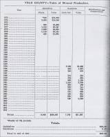
Sandstone Industry (in Yolo County).
“Sandstone beds occur along the ridge near the western border of the county, but they have so far (circa 1913) been undeveloped commercial at only one point – at Devil’s Gate on Putah Creek, west of Winters. Gravel for road work is obtained from the creek beds throughout the county, the owners of the land being paid a per load rate for the privilege. The Southern Pacific Railroad Company formerly took considerable gravel for ballast from Cache Creek near Capay.”
- Yolo,
County, California, Mineral Resources & Introduction to the
Yolo County Area of California (circa 1915) – Excerpt
from Sacramento Valley and Foothill Counties of California:
An Illustrated Description of all the Counties Embraced in this
Richly productive Geographical Subdivision of the Golden State,
compiled and edited by Emmett Phillips and John H. Miller, published
under the direction of The Sacramento Valley Exposition, J. A.
Filcher, Director-in Chief, January, 1915.
Yolo County, by H. S. Maddox
“Situated sixty miles from the Exposition City, in a northeasterly direction; immediately across the Sacramento river from and west of California’s capital city; lying directly between San Francisco, Portland and Sacramento – is Yolo County.
“Almost in the center of California, and the great fertile Sacramento Valley – is Yolo County.
“Our argument has to do primarily and principally with the farmer, the man of family who is seeking a location in the last great West, the Pacific Coast States of America.
“To such a man, three factors stand out most prominently in the development of the varied resources of Yolo County, to wit: in order of their importance, irrigation, reclamation, subdivision. More money has been expended in irrigation enterprises during the past two years than in all previous history; more has been expended in reclaiming low and overflow lands and placing them in a high state of production in the past three years than in all previous years combined. Results? More than twenty subdivision propositions are now on the market, many of them offering small farm units at tempting figures and terms to the purchaser who may have but a little ready cash to apply.
“Water, both surface and subterranean, everywhere present for irrigation at all seasons; with diversified crops intensively farmed, proves conclusively that the man with but a few acres, say twenty to forty, is accomplishing larger and more certain results with less of labor and of worry than the man with an excess of acres.
“Yolo is truly a progressive county. It is really an agricultural community without any great city to overtop and dominate its affairs. There is a cohesiveness about the county that gives it strength. It is governed by a board of five Supervisors, every one of them a man of the soil, individually and collectively; men who think first of the benefit and needs of those who make more grow than ever grew there before. To this end they maintain a County Horticultural Commission with eight assistants who are in constant touch with every farmer in the county; a government ‘Farm Adviser’ who devotes his entire time in the field, giving attention and encouragement to farmers who seek it, maintaining bureaus throughout the county at convenient places where neighborhood meetings are held at frequent intervals; a magnificent public school system with free books for pupils; a free Carnegie library with 53 county branches, and a County Board of Trade with a number of branches in charge of competent men. These organizations are all supported by the County Supervisors, and they obtain funds from no other source, that the home-seeker and investor may be supplied with accurate, unbiased information, advice and helpful suggestions free of charge.
“The county contains nearly half a million acres of about floor level land; the largest contiguous body of unbroken soil of any county in the West. Let us quote Elwood Mead, United States Government soil expert, who in reporting result (sic) of this soil and production investigations in Yolo County said: ‘It is ideal grain, alfalfa and fruit land. You may find growing on this soil wheat, barley, corn, oats, alfalfa; all the vegetables of a temperate and sub-tropical climate; apples, figs, pears, apricots, nectarines, plums, prunes, oranges, lemons, limes, pomegranites, grapes (table, wine and raisin), almonds, olives, English walnuts, berries of all kinds, and melons.’
“The transportation problem has been splendidly solved in Yolo County. A number of steam and electric railways permeate every section of the county, and with a frontage of ninety miles on the Sacramento river, which is always navigable, give every town and village within its borders excellent shipping and marketing facilities.
“Yolo County producers are within one hundred miles of more than one million consuming peoples (sic).
“This county has the lowest tax rate, with but one or two exceptions, of any county in Northern California, and is virtually out of debt with all current bills paid in full.
“This county is favored with nearly one hundred rail and water shipping points. Many of them are splendid towns and villages, having fine schools, churches, a high class American citizenship, and with one or two exceptions, are free of saloons.
“Woodland, the county seat, in the center of the county, is one of the most progressive cities in California, and its clean, well-paved streets are lined with magnificent residences and fine business blocks. Woodland has more money in bank, and bank assets than any town of similar size in the entire country, and this wealth came from Yolo County ’s peerless soil.
“Winters, situated twenty miles southwest of Woodland, is the second largest town in the county. It lies at the base of picturesque hills, and is in the very center of Putah Creek’s rich delta lands.
“Guinda and Rumsey are located near the head of Capay Valley, one of the most beautiful and picturesque spots in the Sacramento Valley.
“Capay is situated where the Capay Valley opens into great Sacramento Valley. Esparto is three miles from the entrance to Capay Valley. Madison is twelve miles west from Woodland. These are all thriving towns in important farming sections.
“Davis is situated on Putah Creek, thirteen miles west of Sacramento and ten miles south of Woodland. It is a railroad junction and enjoys excellent transportation facilities.
“The University farm operated in conjunction with the Agricultural department of the University of California, is situated at Davis. This site was chosen after considering seventy-seven other localities in California. This was due to the superior climate, soil and transportation advantages of Yolo County. The soil is adapted to almonds, fruits of all kinds, and alfalfa.
Dunnigan and Zamorra* are railroad towns in the northern part of the county. Yolo is a flourishing village in the heart of a great fruit county. Then we have Washington and Bryte City just across from Sacramento, also West Sacramento and Clarksburg nearby. All these towns, in fact, all the towns throughout the county, are in flourishing condition. All are making, and will continue, a good substantial growth indefinitely.”
(* Zamorra should be spelled Zamora.)
- Yolo County Mineral Industry (circa 1919) – Excerpt from California Mineral Production for 1919, Bulletin No. 88, by Walter W. Bradley, California State Mining Bureau, 1920, pp. 171.
Area: 1,014 square miles.
Population : 17,105 (1920 census)
Location: Sacramento Valley, bounded by Sutter on the east and Colusa on the north.
“The mineral production from Yolo County during the year 1919 consisted mainly of quicksilver and miscellaneous stone, valued at $25,466, ranking it in fiftieth place. Deposits of undetermined value of iron and sandstone have been discovered within the confines of this county.
“Commercial production for 1919 was as follows:
(Headings for the information below are: Substance, Amount, and Value.)
Stone, miscellaneous, ---, $5,600
Other minerals, ---, $19,866
(Total value) $25,466
Yolo County, 1916 Map, from California Mineral Production for 1919 (with County Maps), Bulletin No. 88, by Walter W. Bradley, California State Mining Bureau, San Francisco: California State Printing Office, 1920, pp. 187. 
- Yolo County Mining
During 1920 – Excerpt from Report XVII
of the State Mineralogist: Mining in California During
1920, California State Mining Bureau, Sacramento,
1921, pp. 260. (This book is available on Google
Book Search - Full View Books.)
Yolo County
“Yolo County is one of the Central Sacramento Valley group. Its mineral resources are limited in number and but slightly developed. Those products that have been commercially produced are quicksilver, sandstone and miscellaneous stone. Deposits of brick clay, coal, gold, iron, limestone, manganese and quicksilver are known and a number of mineral springs are found in the county.
“The location and description of these deposits are given in the Fourteenth Report of the State Mineralogist; the quicksilver mines in the northeastern corner, near the Napa County line, are more particularly described in Bulletin No. 78. When visited during the summer of 1920, Buffords Spring, situated along Putah Creek about nine miles west of Winters, was being improved with the idea of making it a resort.”
- Yolo
County Limestone Deposits (through 1947) – Excerpts
from “Limestone in California,” by Clarence A.
Logan, California Journal of Mines and Geology, Vol. 43, No. 3, July 1947, California Division of Mines, San Francisco, California, pp. 175-357. Used with permission, California Department of Conservation, California Geological Survey.)
“No limestone production has been recorded for Yolo County. Years ago, mention was made of a limestone deposit reported to be in secs. 30 and 31, T. 10 N., R. 2 W., 3 miles south of Cadenassa Station (Bradley, W. W., 16, p. 368).* An anonymous report has recently been found in the Division of Mines files which is dated December 1919 and purports to give the results of a preliminary survey of materials suitable for cement manufacture in the county. The region examined is in and near Capay Valley, from the vicinity of Capay to a point east of Guinda. Several samples were analyzed, but only one was from rock in place. This was a siliceous limestone found ‘south of the county road ½ mile above Capay.’ Two samples of float, one from the J. H. Cranston place and one from the Stephens Agricultural and Livestock Company land near Cranston’s property line, both being above Cadenassa, were found to be of good grade limestone. The same writer also mentioned finding boulders of gray, flinty limestone in Salt Creek west and south of Cadenassa. This he thought came from property owned by E. M. Nash, and Cowell Lime & Cement Company, but a search of several hours over the land failed to show similar rock in place. This is probably the same limestone mentioned by Bradley (16, p. 368).*
(* Walter W. Bradley, “ Yolo County,” California Mining Bureau Report 14, pp. 367-370, 1916.)
“The deposit in place mentioned by this anonymous writer occurs as chalky limestone of marl in a series of low, flat hills along the eastern edge of the valley, and may have been a lake or spring deposit. Pliocene non-marine sediments are shown on the Division of Mines state geologic map along the east side of this valley. The higher land on both sides of the valley is occupied by older marine sedimentary rocks, principally upper Cretaceous, and in these rocks it is not unusual to find occasional small bodies of hard limestone. This is probably the explanation of the lumps and ‘boulders’ of such limestone found, that could not be traced to a deposit in place.
“The soft limestone may eventually have value for agricultural use.”
Analyses of samples of “float” limestone, Yolo County:
SiO2 : (J. H. Cranston) 6.60 percent; (Stephens, A. & L. Co.) 1.40 percent
R2O3: (J. H. Cranston) 0.60 percent; (Stephens, A. & L. Co.) 0.50 percent
CaO: (J. H. Cranston) 50.35 percent; (Stephens, A. & L. Co.) 54.25 percent
MgO: (J. H. Cranston) 0.70 percent; (Stephens, A. & L. Co.) ---
CO2: (J. H. Cranston) 40.90 percent; (Stephens, A. & L. Co.) 42.65 percent
H2O and volatile: (J. H. Cranston) 1.00 percent; (Stephens, A. & L. Co.) 1.10 percent
Totals: (J. H. Cranston) 100.15 percent; (Stephens, A. & L. Co.) 99.90 percent - Yolo County Mines and Mineral Resources (circa 1950) - Excerpts from “Mines and Mineral Resources of Yolo County,” by J. C. O’Brien, District Mining Engineer, California State Division of Mines, in California Journal of Mines and Geology, Vol. 46, No. 3, July 1950, State of California Department of Natural Resources, Division of Mines, pp. 421-436.
(Used with permission, California Department of Conservation, California Geological Survey.)
Abstract
“Yolo County is one of the original 27 counties of California. It is situated in the southwestern part of the fertile Sacramento Valley and 85 percent of its 661,770 acres is in farm land. Its principal mineral production has come from the quicksilver mines in the northwestern corner of the county. These properties were idle when the field work was done for this report in early 1949. The principal activity at that time was in the production of sand and gravel from Cache Creek and Putah Creek. There are 444 acres of proven gas lands in the county with two wells on production and four standing shut-in. The record of the production of other minerals is included from earlier reports.
Introduction (to Yolo County):
“Yolo County is one of the 27 California counties that were created February 28, 1850. Its name was derived from a corruption of Yoloy, the name of an Indian tribe which inhabited the county when it was first settled. The county occupies one of the most fertile portions of the Sacramento Valley. Farming is by far the leading industry and sugar beets are the principal crop. The county has a population of 34,000, an increase of 25 percent since the 1940 census. Woodland, the county seat and largest city, had a population of 8,500 in 1944. It is also the major industrial center with a sugar refinery, fruit and vegetable packing plants and stock yards.
“The climate is dry and generally rainless from May to October but an average of 17 inches of rain falls during the winter months. Snow rarely falls but killing frosts are expected between November 15th and March 20th. The normal mean temperature for January and February is 48 degrees. The average July temperature is 77 degrees. The crop growing season averages 268 days.
“Geography (of Yolo County):
“Yolo County is situated in the southwestern part of the Sacramento Valley. It is bordered on the north by Colusa, on the east by Sutter and Sacramento, on the south by Solano, and on the west by Napa and Lake Counties. It includes 661,770 acres, of which 86 percent or 569,139 acres are privately owned; and 92,621 acres are public lands. There are 481,877 acres in farms and 87,262 acres in forest or grazing lands. Bounded on the east by the Sacramento River, most of the county is in the broad, level floor of the Yolo Basin. The land rises gradually westward into the low foothills of the Coat Range mountains which form the western border of the Sacramento Valley. Elevations are lowest from one to six miles west of the Sacramento river and highest along the western boundary, where a maximum elevation of 1,500 feet is reached. Drainage is northeastward toward the Sacramento River. The principal water resources are Cache and Putah Creeks and Willow Slough. Cache Creek flows from Clear Lake in Lake County and enters Yolo County at the northwestern corner. It flows southeastward and then eastward across the center of the county. Putah Creek rises in the mountains of Napa County and flows eastward forming the southern boundary of the county west of Davis. Both Cache and Putah Creeks are important streams during the rainy season but in the summer months their water disappears before entering the Yolo Bypass. They have cut their way through canyons in the mountains and deposited beds of sand and gravel in the broad valley.
Transportation (in Yolo County circa 1950):
“The main line of the Southern Pacific Railroad runs northward through Davis and Woodland. There are branch lines to Marysville, Winters, and Madison, and to Sacramento, which is on the main line to the east. The Sacramento Northern Railway and its branches operate freight trains in the eastern portion of the county. U.S. Highway 99 W is the main thoroughfare in the east central part of the country; State Highway 16 follows Cache Creek in the west connecting that area with Woodland and Sacramento; and State Highway 28 follows the southern boundary of the county connecting Winters, Davis, and Sacramento. In addition, a total of 875 miles of county and 112 miles of privately maintained roads complete the highway system.
Geology (of Yolo County):
“The geology of Yolo County* is shown on the Geologic Map of California.
“The eastern half of the county lying in the Sacramento Valley is covered with alluvium deposited by the Sacramento River and Cache and Putah Creeks in their flood periods. It includes some of the most fertile land in California. A belt of Pliocene non-marine sediments about 10 miles wide trends northwestward through the north-central portion of the county and a strip about four miles wide extends south along the Coast Range foothills to the southern border. Quaternary and Upper Pliocene sediments lie along the borders of the Pliocene non-marine sediments and the Quaternary alluvium. A narrow strip of upper Eocene marine is exposed on the west side of Cache Creek for about 12 miles below Rumsey. The Coast Range, which forms the western border of the county, is covered with Upper and Lower Cretaceous marine sediments. In the extreme northwest corner of Yolo County, a small area of Tertiary volcanic rocks lies between Jurassic serpentine on the west and the Knoxville formation, which outcrops over an area of 25 square miles. Deposits of quicksilver have been mined in this small area and it is the only metal that has been produced in the county except for a small amount of gold and silver recovered from placers along Cache and Putah Creeks.*
(* Footnote 1, pp. 422: Jenkins, O. P., Geologic map of California, scale 1:500,000: California Div. Mines, 1938.)
Mineral Resources (in Yolo County):
“The principal resources of Yolo County are agricultural, and the value of farm products amounted to $42,957,714 in 1947. The total mineral production from 1873 to 1947 amounts to only $4,183,828. Quicksilver, produced from the mines in the northwestern corner of the country, was the chief mineral product, followed by miscellaneous stone, sandstone, and natural gas. A few thousand dollars in gold were mined from Cache and Putah Creeks. Some low grade gold quartz veins were found in the western foothills but no gold mines have been developed. Common brick was reported manufactured from clay beds near Woodland, Winters, and Capay,* but the industry has been idle for many years. Quicksilver mines are able to operate only in abnormal periods when the price of quicksilver is high. The mines were idle when the field work was done for this report. The principal activity was in the sand and gravel business, and practically all of this material was being used to build roads and driveways. Natural gas from two wells in the Fairfield Knolls gas field flows into the Rio Vista gas line, and there are four potential producing gas wells standing shut-in in the Dunnigan Hills area north of Woodland. There were 444 acres included in the proven gas fields in December, 1947.**
(* Footnote 2, pp. 423: Watts, W. L., Yolo County California Min. Bur. Report 10, pp. 791-792, 1890.)
(** Footnote 3, pp. 423: California Oil Fields: California Div. Oil and Gas, vol. 33, no. 2, p. 82, 1947.)
(NOTE: Only the sections on “Building Stone” and “Limestone” are being presented here. The following sections will NOT be presented here: Clay, Gold, Mineral Water, Miscellaneous Stone, Natural Gas, and Quicksilver. If you are interested in the other mineral resources in Yolo County, feel free to contact me. Peggy B. Perazzo)
Building Stone* (in Yolo County):
“Bluish-gray sandstone was quarried at the Devil’s Gate, in Putah Canyon, about 9 miles west of Winters between 1894** and 1908. The stone occurs in beds from 12 to 15 feet thick, and it has frequently been split into slabs 14 feet long, 16 inches wide, and 10 inches thick. It has a smooth grain free from pebbles and was used for monuments and as a building stone for many years.
“A volcanic tuff deposit occurs in the foothills west of Winters. Selected material was used to build houses in Winters many years ago. It is a soft whitish rock which becomes hard on exposure to the air and appears to weather remarkably well.”
(* Footnote 4, pp. 423: Watts, E. L., Yolo County: California Min. Bur. Rept. 10, p. 791, 1890.)
(** This July 1950 California Division of Mines publication indicates that the quarry was operated between 1894 and 1908, but other records document that the Bertholet building was constructed in 1892 - two years prior to the 1894 date. The date of construction of the building - 1892 - is displayed near the top of the front of the building. Peggy B. Perazzo)
The following summary information on Sandstone is taken from Table 1. Mineral production of Yolo County, 1873-1947” on page 424:
(The headings for the information below are: Year, Sandstone - Cubic feet & Value.)
1894 - 2,500 cubic feet - $1,000
1895 - 542 cubic feet - $1,837
1896 - 252 cubic feet - $378
1897 - --- ---
1898 - 264 cubic feet - $384
1899 - 264 cubic feet - $384
1900 - 908 cubic feet - $1,760
1901 - 1,540 cubic feet - $2,300
1902 - 328 cubic feet - $450
1903 - 280 cubic feet - $144
1904 - 180 cubic feet - $720
1905 - 175 cubic feet - $200
1906 - 160 cubic feet - $204
1907 - 250 cubic feet - $350
1908 - 140 cubic feet - $1,150
(Totals) - 7,783 cubic feet - $11,297
Limestone (in Yolo County):
“No limestone production has been recorded from Yolo County.* Years ago, mention was made of a limestone deposit reported to be in secs. 30 and 31, T. 10 N., R. 2 W., M.D., 3 miles south of Cadenassa Station.** Pliocene non-marine sediments occur*** along the east side of this valley. The higher land on both sides of the valley is occupied by older marine sedimentary rocks, principally Upper Cretaceous, and in these rocks it is not unusual to find occasional small bodies of hard limestone. This is probably the explanation of the lumps and boulders of such limestone found, which could not be traced to a deposit in place. The soft limestone may eventually have value for agricultural use.
(* Footnote 6, pp. 425: Logan, C. A., Limestone in California, California Div. Mines Rept. 43, p. 350, 1947.)
(** Footnote 7, pp. 425: Bradley, W. W., Yolo County: California Min. Bur. Rept. 14, p. 368, 1913.)
(*** Footnote 8, pp. 425: Jenkins, O.P., Geologic map of California, scale 1:500,000, California Div. Mines, 1938.)


Commercial use of material within this site is strictly prohibited. It is not to be captured, reworked, and placed inside another web site ©. All rights reserved. Peggy B. and George (Pat) Perazzo (deceased).