
Shasta County - List of Stone Quarries, Etc.*
(* Please note this list does not include sand or gravel quarries.)
-
Big Backbone Canyon and Little Backbone Canyon, Shasta County, California – Limestone
Quarry and Kilns of Holt & Gregg (Limestone & Kiln) (From The
Structural and Industrial Materials of California, Bulletin No. 38, California,
State Mining Bureau, San Francisco, California, 1906.)
“The deposit in Secs. 28 and 34, T. 34 N. R. 5 W., Holt & Gregg, Redding, owners, was formerly quarried on the north side, on the Big Backbone side (see Sketch D), and burned in kilns in Section 34, in Big Backbone Cañon. The new quarry is on the south slope toward Little Backbone and the Kilns at Kennett. The quarry is worked by hand-drilling; the blocks are sledged down to pieces from 12 inches to 4 inches; pieces below 4 inches are thrown over the dump. At the kiln the stone is further broken to pieces running from 6 inches to 3 inches. The kilns are modified patent shaft kilns, with iron sheeting, having a capacity of 7 ½ tons of lime per twenty-four hours, using wood as fuel. The lime is used all over northern California.”
Ill. No. 37. Sketch D, Shasta County. 
-
Briggsville, Shasta County, California – Limestone Quarry & Kiln (Limestone) – Excerpt from the Tenth Annual Report of The State Mineralogist For The Year Ending December 1, 1890, California State Mining Bureau, Sacramento: State Printing Office, 1890, pp. 627.
Shasta County, by Alex. McGregor, Assistant in the Field.
- Clear Creek (north side of), Shasta County, California – Dr. Th. R. Heintz - Limestone Deposit (Limestone) (From The Structural and Industrial Materials of California, Bulletin No. 38, California, State Mining Bureau, San Francisco, California, 1906.)

“About one mile south from Oregon Gulch, we come to Olney Creek....About four and a half miles south of Redding, leaving Olney Creek at the township of old Middletown, we traveled due south a distance of three miles to where the old town of Briggsville once stood. It was a large camp containing hotels and stores, but now deserted; not even the vestige of a house is left. Here we encounter a large ledge of lime rock, in Sec. 31, T. 31 N., R. 5 W., M.D.M. It was worked in early days, and supplied all the lime for the surrounding country. The old lime kiln is there yet (circa 1890). The rock crops out to a height of fifty feet, and is visible for about two thousand feet on the surface; it trends northeast and dips southeast. It is situated on the bank of Bulger Gulch, which extends to Clear Creek....”
- Etna (southwest of & north of), Shasta County, California – Granite Quarries (Granite) (Excerpt from chapter in “California” (pdf), by G. F. Loughlin, in the Mineral Resources of the United States Calendar Year 1913, Part II. Nonmetals, United States Geological Survey, 1914, pp. 1357.)
- Girvan (6 miles from), Shasta County, California – Briggsville (Mooretown) Limestone Deposit (Limestone) (Excerpt from "Limestone in California," by Clarence A. Logan, California Journal of Mines and Geology, Vol. 43, No. 3, July 1947, California Division of Mines, San Francisco, California, pp. 175-357. Used with permission, California Department of Conservation, California Geological Survey.)
"The limestone in Sec. 31, T. 31 N., R. 5 W., Dr. Th. R. Heintz, Redding, owner, forms a prominent bluff on the north side of Clear Creek, from 60 to 70 feet high and 300 feet long. The limestone can be traced farther up the hill to about 110 feet above its lowest exposure, where it is overlaid by black shales. Mr. J. S. Diller (Bulletin U. S. Geological Survey, No. 213, page 365) classified this limestone as Devonian.
"There is a small outcrop of the same limestone just opposite on the south side of Clear Creek. The remnants of an old limekiln are found at the foot of the bluffs; formerly a great amount of lime was burned here and was shipped as far as Colusa."
“Gray granite has been quarried in Siskiyou County for monumental work 4 miles southwest of Etna and a nearly black rock (uralitic gabbro) 16 miles north of that place.”
-
Igo (east of), Shasta County, California – Jewel Granite Quarry
(Granite) (Excerpt from Report XIV of the State Mineralogist - Mines
and Mineral Resources of Portions of California, Chapters of State Mineralogist's
Report - Biennial Period 1913-1914, Part VI. “The Counties of
Shasta, Siskiyou, Trinity,” by G. Chester Brown, Field Assistant (field
work in November, 1913), California State Mining Bureau, San Francisco,
California, 1916, pp. 746-925.)
"Jewel Quarry is located in Sec. 25, T. 31 N., R. 6 W., 2 ½ miles east of Igo. Massive deposit. Rock grayish in color and similar to Masterton deposit. It has not been worked for several years."
-
Ingot (northeast of), Shasta County, California – Emerald Glen
Ranch Limestone Deposits (Limestone) (Excerpt from "Limestone
in California," by Clarence A. Logan, California Journal of Mines
and Geology, Vol. 43, No. 3, July 1947, California Division of Mines,
San Francisco, California, pp. 175-357. Used with permission, California
Department of Conservation, California Geological Survey.)
"Emerald Glen Ranch, A. J. Woolsey trustee, et al. The deposit is 2 miles northeast of Ingot, near where the highway passes the corner common to T. 33 and 34 N., R. 1 and 2 W., on a deposit of the Hosselkus limestone. The limestone here is in two bodies, one 60 feet thick and the other 100 feet thick, the two being separated by 150 feet of dark shales. Spot samples were taken and analyzed in 1945 from the north part of sec. 6, T. 33 N., R 1 W., and nearby in sec. 36, T. 34 N., R. 2 W., by a company using much limestone; they have kindly made the following analyses available."
Analyses of Hosselkus limestone, 2 miles northeast of Ingot (Emerald Glen Ranch)
SiO2: 3.39 percent; 2.75 percent; 0.63 percent; 2.21 percent; 1.89 percent; and 1.08 percent
R2O3: 0.44 percent; 0.40 percent; 0.50 percent; 0.28 percent; 0.29 percent; and 0.32 percent
CaCO3: 95.52 percent; 95.90 percent; 98.30 percent; 96.91 percent; and 97.79 percent
MgCO3: 0.21 percent; 0.45 percent; 0.31 percent; 0.35 percent; 0.45 percent; and 0.52 percent"This limestone would probably have many uses, including the making of lump lime. The distance from railroad, about 25 miles, is perhaps the chief factor in considering it. It lies at an elevation of 1200 to 1300 feet and grades favor traffic to the railroad at Redding."
-
Kennett (north of), Shasta County, California – Alta Lime and
Brick Company Limestone Deposit (Limestone & Lime Kiln) (Excerpt
from "Limestone in California," by Clarence A. Logan, California
Journal of Mines and Geology, Vol. 43, No. 3, July 1947, California
Division of Mines, San Francisco, California, pp. 175-357. Used with permission,
California Department of Conservation, California Geological Survey.)
"Alta Lime and Brick Company began work in 1904 on a deposit of Devonian limestone in sec. 22, T. 34 N., R. 5 W., 4 miles north of Kennett, and started a lime kiln in section 24. There is no further record of activity, although the largest area of Devonian limestone in the vicinity of Kennett is in section 22. The north half and southwest quarter of this section are now shown to be owned by the United States, and the southeast quarter is shown to be owned by E. J. Gorman, on the County Assessor's records."
-
Kennett (northwest of), Shasta County, California – Holt and
Gregg Limestone Quarry & Kiln (at Kennett) (Limestone & Kiln) (Excerpt
from Report XIV of the State Mineralogist - Mines and Mineral Resources
of Portions of California, Chapters of State Mineralogist's Report - Biennial
Period 1913-1914, Part VI. "The Counties of Shasta, Siskiyou, Trinity," by G. Chester Brown, Field Assistant (field work in November, 1913), California
State Mining Bureau, San Francisco, California, 1916, pp. 746-925.)
"Holt & Gregg Quarry is located in Sec. 32, T. 34 N., R. 5 W., and consists of 120 acres, patented, about 2 miles northwest of Kennett, on the south slope toward Little Backbone Creek, at an elevation of 2000 feet. This excellent limestone deposit, on the western belt, is owned by Holt & Gregg, of Redding; F. M. Kindelberger, superintendent. Quarrying method of mining used. The limestone is hauled to the kilns at Kennett, a distance of 2 miles, by means of an electric railway, power being obtained from the Northern California Power Company (see photo No. 7). The crude material is roasted in three Hoffman continuous kilns, crude oil being used for fuel. Lime removed every two hours. Output is 25 tons in twenty-four hours. Product is of an excellent grade and sold extensively throughout California. Thirteen men employed (circa 1913)."
(Also see: Shasta County, California - Mountain Copper Company Limestone Deposit below.)
Photo No. 7. Holt & Gregg Lime Plant, Kennett. 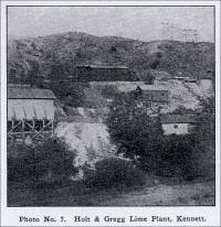
- Shasta County, California – Holt and Greg Limestone Deposit (Limestone) (Excerpts from “Limestone in California,” by Clarence A. Logan, California Journal of Mines and Geology, Vol. 43, No. 3, July 1947, California Division of Mines, San Francisco, California, pp. 175-357. Used with permission, California Department of Conservation, California Geological Survey.)
“Holt and Gregg deposit is owned by U. S. Smelting, Refining, & Mining Exploration Company, 921 Newhouse Building, Salt Lake City, and is located in W ½ sec. 34, T. 34 N., R. 5 W. This quarry, and another worked before it, which is farther east in the same section, supplied lime for general use in the region, and also supplied large tonnages of limestone for copper-smelter flux to smelters at Kennett and Keswick. Practically no production has been made for 20 years.
“It is Devonian limestone and was reported in 1896 to carry 97 percent calcium carbonate (CaCO3, 2 percent magnesium carbonate and 1 percent silica. (Crawford, J. J. 96, p. 632).* Another reported analysis, published in 1888 (Irelan, W. Jr. 88, p. 572),** probably represented the stone from the first Holt and Gregg quarry, east of the later one. It was as follows:
Carbonate of lime, 95.2 percent
Silica, 4.4 percent
Magnesia (carbonate ?), 0.5 percent
Carbon (organic), Trace
Total, 100.1 percent(* J. J. Crawford, Thirteenth Report (Third Biennial) of the State Mineralogist for the Two Years Ending September 15, 1896, California Mining Bureau Report 13, 726 pp., 1896.)
(** William Irelan, Jr., Eighth Annual Report of the State Mineralogist for the Year Ending October 1, 1888, California Mining Bureau Report 8, 948 pp. illus., 1888.)
“This deposit is now almost 6 miles from the railroad and separated from it by the water behind Shasta Dam.”
- Shasta County, California – Holt and Greg Limestone Deposit (Limestone) (Excerpts from “Limestone in California,” by Clarence A. Logan, California Journal of Mines and Geology, Vol. 43, No. 3, July 1947, California Division of Mines, San Francisco, California, pp. 175-357. Used with permission, California Department of Conservation, California Geological Survey.)
-
Millville (4 miles from), Shasta County, California - Lew Smith Sandstone Quarry (Sandstone) (This material was transcribed by Betty Loose, from the Sacramento Evening Bee, Wednesday, February 8, 1905.)
“STONE MAY PROVE VALUABLE FOR FIRE PROOF BUILDINGS MILLVILLE (Shasta Co.), February 8 (1905) - A few samples of sandstone, or a lava sediment, have been brought in from South Cow Creek by Lew SMITH and await shipment to a contractor and builder at Sacramento, who will examine and determine whether he can make use of the rock for building purposes.
“About 1000 acres, containing immense quantities of this valuable rock, lie a few miles east of this place. The rock being fireproof, is especially adapted for fire-places, chimneys, etc. The church at this place is built of this rock and is a very substantial structure.
- Pit River (north of), Shasta County, California – Brock Mountain Limestone Deposit (Limestone) (Excerpt from "Limestone in California," by Clarence A. Logan, California Journal of Mines and Geology, Vol. 43, No. 3, July 1947, California Division of Mines, San Francisco, California, pp. 175-357. Used with permission, California Department of Conservation, California Geological Survey.)
"Briggsville (Mooretoen) limestone is on Clear Creek, in sec. 31, T. 31 N., R. 5 W., 6 miles by road from Girvan on the railroad. In the early gold-mining days Briggsville was an important camp, and the limestone from the deposit there was burned in a stone kiln and supplied an extensive area. No production is known to have been made since 1925 when J. H. Hill marketed a few hundred tons of slaked lime for agricultural use. Where seen by the writer, near the bank of Clear Creek in the north half of section 31, a lens of limestone nearly 100 feet thick outcrops on the slope near the roadside. The exact size could not be judged because it dips into the hill and is covered by black shale. It strikes northwest in a lens of Kennett (Devonian) formation which is about a mile long, with limestone exposed in separate outcrops for about half a mile.
Analysis of Briggsville limestone (Devonian)
SiO2, 3.67 percent
R2O3, 0.24 percent
CaCO3, 95.14 percent
MgCO3, 0.56 percent

“About twenty years ago the first quarry was established about four miles from Millville by F. C. KEY, who successfully conducted the establishment about fifteen years. Chimneys, fireplaces and buildings were constructed of the rock in those days, and to-day they remain as a monument of the builder's handiwork. Key died about five years ago in the County Hospital, since which time the quarry has been abandoned. Upon the death of Key, the land fell to the Ross estate, which held a big mortgage on it. This estate still owns the quarry and about ten acres of the land. The remaining 150 acres of the original Key's holdings were sold to Milt FARRELL a few years ago and he is using some of the land as a sheep range.”
-
Redding (northeast of), Shasta County, California – Asher Limestone
Deposit (Limestone) (Excerpt from "Limestone in California," by Clarence A. Logan, California Journal of Mines and Geology, Vol.
43, No. 3, July 1947, California Division of Mines, San Francisco, California,
pp. 175-357. Used with permission, California Department of Conservation,
California Geological Survey.)
"Asher limestone deposit is owned by James Asher et al. This is part of the Hosselkus (Triassic) limestone 25 to 30 miles northeast of Redding on or near the highway leading to Alturas. The Asher land from which samples were taken for the analyses shown below, is in N ½ lots 3 and 4, sec. 1, and NE ¼ lot 1, sec. 2, T. 33 N., R. 2 W., M.D., 1 to 1 ½ miles northeast of Furnaceville; but the deposit is partly in each of 4 townships near their common corner. The highway runs on or along the deposit for several miles.
"The Hosselkus limestone has been studied and described by several eminent geologists, including J. P. Smith and J. S. Diller, and the latter states that in this vicinity, 'on the spur southwest of the mouth of Cedar Creek, two limestones occur, one 60 feet and the other approximately 100 feet thick, separated by 150 feet of dark shales. The whole set of beds dips to the southwest and is evidently overturned.' It is rather hard, somewhat siliceous, dark colored, and shows numerous fossils, with corals abundant in the upper part.
"It has been sampled recently because of its suitability for burning in vertical kilns. The following analyses are of 'spot' samples taken in 1945 by an engineer for a company using a large amount of limestone, and were analyzed in the company laboratory. They have asked that their name be withheld."
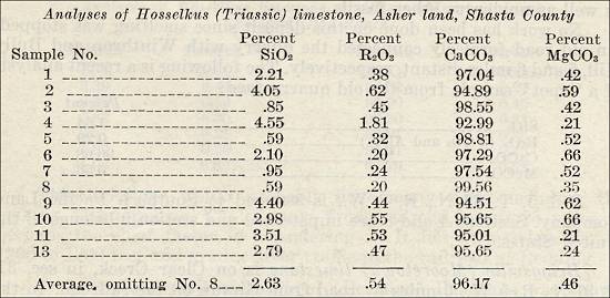
Analyses of Hosselkus (Triassic) limestone, Asher land, Shasta County -
Redding (northeast of), Shasta County, California – Bear Mountain
Limestone Deposit (Limestone) (Excerpt from "Limestone in California," by Clarence A. Logan, California Journal of Mines and Geology, Vol.
43, No. 3, July 1947, California Division of Mines, San Francisco, California,
pp. 175-357. Used with permission, California Department of Conservation,
California Geological Survey.)
"Bear Mountain occupies most of the S ½ sec. 12, T. 33 N., R. 4 W. and W ½ sec. 7, T. 33 N., R. 3 W., about 12 miles in an airline north-northeast of Redding. A bed of Hosselkus limestone, 50 feet thick in places, forms an irregular ring around most of the mountain at an elevation of about 2000 feet. It is covered by Jurassic beds. A Forest Service road gives access to the limestone in section 7. No work has been done on the deposit, so far as known. A sample taken near the road was analyzed by a company interested in new sources of supply, and they have kindly made the analysis available, as follows:
SiO2, 0.96 percent
R2O3 (Fe2O3 and Al2O3), 0.58 percent
CaCO3, 97.18 percent
MgCO3, 0.69 percent -
Redding (northeast of), Shasta County, California – Bibbens Limestone
Deposit (Limestone) (Excerpt from "Limestone in California," by Clarence A. Logan, California Journal of Mines and Geology, Vol.
43, No. 3, July 1947, California Division of Mines, San Francisco, California,
pp. 175-357. Used with permission, California Department of Conservation,
California Geological Survey.)
"Bibbens limestone deposit is owned by the Bibbens heirs. This is part of the large deposit described under Asher (above). This land is in SE ¼ SE ¼ SE ¼ sec. 35, T. 34 N., R. 2 W."
"The following is an analysis of the limestone:
SiO2, 1.87 percent
R2O3 (Fe, Al oxides), 0.26 percent
CaCO3, 97.29 percent
MgCO3, 0.24 percent -
Redding, Shasta County, California - Igneous Rock Quarry (Igneous Rock) (From
The Structural and Industrial Materials of California, Bulletin No. 38,
California, State Mining Bureau, San Francisco, California, 1906.)
"Macadam is used for the streets of Redding. The rock quarry and crushing plant are located in the northwestern part of town. The rock is an altered, siliceous, igneous rock, quarried by hand drilling. It is crushed in a jaw crusher, and then passed over a 2-inch screen. The larger pieces are used as a foundation in the streets, the finer for top covering and for sidewalks. The crusher is driven by electric power."
- Redding, California, Shasta County, California - "Limestone of the Redding District, California," by. J. S. Diller, from Contributions to Economic Geology 1902, Bulletin 213 United States Geological Survey, 1903.
-
Redding (northwest of), Shasta County, California – Redding Municipal
Quarry (Macadam) (Excerpt from Report XIV of the State Mineralogist
- Mines and Mineral Resources of Portions of California, Chapters of State
Mineralogist's Report - Biennial Period 1913-1914, Part VI. "The
Counties of Shasta, Siskiyou, Trinity," by G. Chester Brown, Field
Assistant (field work in November, 1913), California State Mining Bureau,
San Francisco, California, 1916, pp. 746-925.)
"The macadam used for the streets of Redding comes from the Redding Municipal Quarry, located in Sec. 29, T. 32 N., R. 5 W., 1 mile northwest of this city. The holdings consist of 30 acres, patented. The quarry work is under the direction of the superintendent of streets. The rock is altered, siliceous in character, and igneous in origin. The deposit is massive and easily worked…."
-
Redding (northeast of), Shasta County, California – the Sandflat
Quarry (Sandstone) (From The Structural and Industrial Materials
of California, Bulletin No. 38, California, State Mining Bureau, San
Francisco, California, 1906.)
"Sandflat Quarry, in Section 18; A. Dutton, Redding, owner."
-
Redding (northeast of), Shasta County, California – Sandstone
Deposit (Sandstone) (Excerpt from Report XIV of the State Mineralogist
- Mines and Mineral Resources of Portions of California, Chapters of State
Mineralogist's Report - Biennial Period 1913-1914, Part VI. "The
Counties of Shasta, Siskiyou, Trinity," by G. Chester Brown, Field
Assistant (field work in November, 1913), California State Mining Bureau,
San Francisco, California, 1916, pp. 746-925.)
"A few miles northeast of Redding the Cretaceous Chico sandstone forms the surface rocks of Secs. 7 and 18, T. 32 N., R. 4 W. This deposit occurs in thick horizontal beds so that the quarrying of large blocks is a simple matter. Rock has a tawny color, quality is fair…."
-
Redding (northeast of), Shasta County, California – the Stillwater
Quarry (Sandstone) (From The Structural and Industrial Materials
of California, Bulletin No. 38, California, State Mining Bureau, San
Francisco, California, 1906.)
"Stillwater Quarry, in Section 7; F. H. Dakin, 104 Sutter street, San Francisco, owner."
-
Shasta County, California – Bass Ranch Limestone Deposit
Bass Ranch Limestone Deposit - See: Shasta County, California – Gray Rocks Limestone/Marble Deposit below.
-
Shasta County, California – Bayha Land Company
Bayha Land Company - See: Shasta County, California – Gray Rocks Limestone/Marble Deposit below.
-
Shasta County, California – Bear Gulch Limestone Quarry (Limestone)
(active ca 1996) (From Mines and Mineral Producers Active in California
(1994-1995), Special Publication 103 (Revised 1996), California Department
of Conservation, Division of Mines and Geology, in cooperation with California
Department of Conservation, Office of Mine Reclamation. Used with permission,
California Department of Conservation, California Geological Survey.)
Mine name: Bear Gulch Limestone Quarry; Operator: Bear Gulch Enterprises, Inc.; Address & County: P. O. Box 494850, Redding, CA 96049, Shasta County; Phone: (916) 221-3406; Latitude: 40.76, Longitude: -122.05, and Mine location number: Map No. 738; Mineral commodity: Limestone.
- Shasta County, California – W. R. Conant (Soapstone and/or Talc) (From The Structural and Industrial Materials of California, Bulletin No. 38, California, State Mining Bureau, San Francisco, California, 1906.) (No other information is given.)
-
Shasta County, California – Doak Limestone Deposit (Limestone) (Excerpt from "Limestone in California," by Clarence A. Logan, California Journal of Mines and Geology, Vol. 43, No. 3, July 1947,
California Division of Mines, San Francisco, California, pp. 175-357. Used
with permission, California Department of Conservation, California Geological
Survey.)
"Doak deposit is now owned by the United States. It is in SE ¼ sec. 23, T. 34 N., R. 4 W. This is part of the McCloud limestone, between 1000 and 1600 feet in elevation, a quarter to half a mile southeast of the site of the old Baird Fishery, and east of McCloud River. It has not been developed, but another part of the deposit nearby in section 26 was worked over a long period of time and was found to be a high-calcium limestone. It is probable that analyses quoted for the latter under Shasta Iron Company would be very close to the figures obtainable for the Doak portion of deposit. The lower part of this deposit up to 1065 feet elevation will be flooded when water is high in Shasta Dam."
-
Shasta County, California – Fawndale Rock Quarry (Stone) (active
ca 1996) (From Mines and Mineral Producers Active in California (1994-1995),
Special Publication 103 (Revised 1996), California Department of Conservation,
Division of Mines and Geology, in cooperation with California Department
of Conservation, Office of Mine Reclamation. Used with permission, California
Department of Conservation, California Geological Survey.)
Mine name: Fawndale Rock Quarry; Operator: Fawndale Rock & Asphalt; Address & County: P. O. Box 994248, Redding, CA 96099-4248, Shasta County; Phone: (916) 241-2112; Latitude: 40.74, Longitude: -122.31, and Mine location number: Map No. 750; Mineral commodity: Stone.
-
Shasta County, California – Gray Rocks Marble Deposit (Limestone
& Marble) (Excerpt from Report XIV of the State Mineralogist
- Mines and Mineral Resources of Portions of California, Chapters of State
Mineralogist's Report - Biennial Period 1913-1914, Part VI. "The
Counties of Shasta, Siskiyou, Trinity," by G. Chester Brown, Field
Assistant (field work in November, 1913), California State Mining Bureau,
San Francisco, California, 1916, pp. 746-925.)
"Marble is found in Sec. 3, T. 33 N., R. 4 W., about 5 miles east of Kennett. The quality and extent is not known, as the deposit is considerably broken up on the surface and has not been developed.
"Bibl.: Report VI, p. 98; Bull. No. 38, p. 107.
-
Shasta County, California – Gray Rocks Limestone/Marble Deposit
(Limestone & Marble) (Excerpt from "Limestone in California," by Clarence A. Logan, California Journal of Mines and Geology,
Vol. 43, No. 3, July 1947, California Division of Mines, San Francisco,
California, pp. 175-357. Used with permission, California Department of
Conservation, California Geological Survey.)
"Gray Rocks deposit of McCloud (Permian) limestone was known to the earlier geologists as Bass Ranch deposit and has been described in some early Division Mines reports under Bayha Land Company. It lies mostly in the E ½ sec. 3, T. 33 N., R. 4 W., but part of the Lime Mountain Consolidated claim is in sec. 2. These lands are assessed to Theodore Barnes et al. On the north the limestone extends into secs. 34 and 35, T. 34 N., R. 4 W.
"The deposit rises to an elevation of 2400 feet, or over 1300 feet above the level of Shasta Dam. Like most of this limestone, the deposit rests on a large intrusive dike of quartz-augite diorite which invaded the contact between it and the underlying Baird formation. This has shattered (and) the limestone and the seams between the blocks have been filled by intrusive, the result being a rather steep ridge covered by rough masses of limestone trending north. Due to the action of the intrusive, much of the limestone has been changed to gray fine-grained marble, with contact minerals and siliceous zones nearest the intrusive. It varies in thickness from a capping to a maximum of 800 feet on the north, according to H. W. Fairbanks (93).*
(* Harold Wellman Fairbanks, "Geology and Mineralogy of Shasta County," California Mining Bureau Report 11, pp. 24-53, map, 1893.)
"The relocation main line of the Southern Pacific Railroad now passes 1 mile west of the summit of Gray Rocks, and the state highway crosses the western part of section 3.
"There is no record of any production from this deposit."
-
Shasta County, California – Gray Rock Quarry (Limestone)
(active ca 1996) (From Mines and Mineral Producers Active in California
(1994-1995), Special Publication 103 (Revised 1996), California Department
of Conservation, Division of Mines and Geology, in cooperation with California
Department of Conservation, Office of Mine Reclamation. Used with permission,
California Department of Conservation, California Geological Survey.)
Mine name: Gray Rock Quarry; Operator: Calaveras Cement Company; Address & County: 15390 Wonderland Blvd., Redding, CA 96003, Shasta County; Phone: (916) 275-1581; Latitude: 40.75, Longitude: -122.30, and Mine location number: Map No. 752; Mineral commodity: Limestone.
-
Shasta County, California – Gray Rocks Limestone/Marble Deposit
(Limestone & Marble) (Excerpt from "Limestone in California," by Clarence A. Logan, California Journal of Mines and Geology,
Vol. 43, No. 3, July 1947, California Division of Mines, San Francisco,
California, pp. 175-357. Used with permission, California Department of
Conservation, California Geological Survey.)
-
Shasta County, California – Mountain Copper Company Limestone
Deposit (Limestone) (Excerpt from "Limestone in California," by Clarence A. Logan, California Journal of Mines and Geology, Vol.
43, No. 3, July 1947, California Division of Mines, San Francisco, California,
pp. 175-357. Used with permission, California Department of Conservation,
California Geological Survey.)
"Mountain Copper Company. During the operation of the copper smelter at Keswick over 40 years ago, this company obtained the limestone for smelter flux from a deposit of Devonian age principally in SE ¼ sec. 32, T. 34 N., R. 5 W. So far as known, no work has been done there in recent years. The quarry is 7 miles from the present railroad and separated from it by Shasta Dam."
(Also see: Kennett (northwest of), Shasta County – Holt & Gregg Limestone Quarry above.)
-
Shasta County, California – Mountain Gate Limestone Quarry (Limestone)
(active ca 1996) (From Mines and Mineral Producers Active in California
(1994-1995), Special Publication 103 (Revised 1996), California Department
of Conservation, Division of Mines and Geology, in cooperation with California
Department of Conservation, Office of Mine Reclamation. Used with permission,
California Department of Conservation, California Geological Survey.)
Mine name: Mountain Gate Limestone Quarry; Operator: Mountain Gate Limestone Quarry; Address & County: P. O. Box 493099, Redding, CA 96049, Shasta County; Phone: (916) 221-3406; Latitude: 40.73, Longitude: -122.31, and Mine location number: Map No. 754; Mineral commodity: Limestone.
-
Shasta County, California – Moxley Limestone Deposit (Limestone) (Excerpt from "Limestone in California," by Clarence A. Logan, California Journal of Mines and Geology, Vol. 43, No. 3, July 1947,
California Division of Mines, San Francisco, California, pp. 175-357. Used
with permission, California Department of Conservation, California Geological
Survey.)
"Moxley deposit is in fractional sec. 13, T. 34 N., R. 4 W., most of which, except for half of the southeast quarter, is covered by the McCloud (Permian) limestone. The southwest quarter of the southwest quarter belongs to the state. All the balance is assessed to Thomas R. Woods. It forms the conspicuous mountain rising to an elevation of 3114 feet about 1 ½ miles northeast of Baird Fishery. In this region the limestone shows its greatest apparent thickness. The contact of the underlying quartz-augite diorite with limestone on the west is at an elevation of about 1500 feet. Of course the contour of the top of the intrusive is probably irregular, so that in the absence of careful examination and drilling or other prospecting, no very close estimates of tonnage can be made. However, an area of 267 acres (which is about half the area mapped as limestone in this section on the Redding folio of U. S. Geological Survey) would cover nearly 100,000,000 tons of limestone for each 100 feet in depth. In the Redding folio Diller (06)* states it has a thickness here of 'approximately 2000 feet.' J. D. Whitney stated it was 1000 feet thick and H. W. Fairbanks believed it to be much greater, 'probably twice that amount.'
(* J. S. Diller, Description of the Redding Quadrangle, California, U. S. Geological Survey, Geological Atlas, Redding Folio (no. 138), 14 pp., maps, 1906.)
"The description of McCloud limestone by Norman E. A. Hinds (33)* previously quoted applies to this deposit and needs not be repeated. The chemical character is indicated by analysis shown below.
(* Norman E. A. Hinds, "Geologic Formations of the Redding-Weaverville District, Northern California," California Division of Mines Report 29, pp. 77-122, 1933.)
"For many years, this land and adjoining claims on the lower slopes of the mountain in sections 14 and 23 were held as a source of supply of limestone for a proposed portland cement plant by Shasta Cement Materials Association. The rise of the water behind Shasta Dam to a maximum level of 1065 feet elevation has changed conditions. The main line of the Southern Pacific Railroad is now only 2 miles southwest of the west line of section 13, and satisfactory arrangements could probably be made to deliver limestone to the west shore of the lake by barges, within a short distance of a spur track, or to a plant. The lake is about 4500 feet wide at the old fish-hatchery site.
"The following are analyses of limestone samples taken by E. W. D. Johnson and the late M. E. Dittmar from the deposits. Dittmar was the moving spirit in Shasta Cement Materials Association, and supplied the analyses.
Analyses of McCloud limestone, secs. 13, 14, 23, T. 34 N., R. 4 W.
SiO2: (1) 1.10 percent; (2) 0.41 percent; (3) 1.02 percent; (4) 0.60 percent; (5) 0.60 percent
Iron oxide: (1) 0.20 percent; (2) 0.49 percent; (3) 0.20 percent; (4) 0.30 percent; (5) 0.30 percent
Alumina: (1) 0.24 percent; (2) 0.64 percent; (3) 0.61 percent; (4) 0.40 percent; (5) 0.40 percent
Magnesia: (1) 2.38 percent; (2) 0.36 percent; (3) 1.12 percent; (4) (blank); (5) (blank)
McCO3: (1) (blank); (2) (blank); (3) (blank); (4) 0.81 percent; (5) 1.98 percent
CaO: (1) 52.16 percent; (2) (blank); (3) (blank); (4) (blank); (5) (blank)
CaCO3: (1) (blank); (2) 97.57 percent; (3) 96.07 percent; (4) 98.09 percent; (5) 95.33 percent
Loss on ignition: (1) 43.96 percent -
Shasta County, California – Shasta Cement Materials Association
Limestone Deposits (Limestone) (Excerpt from "Limestone in California," by Clarence A. Logan, California Journal of Mines and Geology, Vol.
43, No. 3, July 1947, California Division of Mines, San Francisco, California,
pp. 175-357. Used with permission, California Department of Conservation,
California Geological Survey.)
"Shasta Cement Materials Association, c/o D. V. Saeltzer, Redding, has for 20 years or more held 320 acres of patented land containing shale in sec. 16, two 160-acre unpatented claims on limestone in secs. 14 and 23, and an option on the Moxley limestone deposit covering sec. 13, all in T. 34 N., R. 4 W. The limestone claims are the lower, western part of the immense deposit of McCloud limestone in sec. 13, and would be the logical place to begin quarrying. So far only assessment work has been done (circa 1947).
"Before the erection of Shasta Dam the association had plans for building a cement plant on the low land between the limestone and McCloud River. The raising of water to a maximum of 1065 feet elevation behind the dam would prevent this now. However, the main-line railroad has been moved to within 2 miles of the deposit, and cheap barge transportation could no doubt be arranged across the lake with a landing in sec. 22 or 27 within a short distance of the railroad. The lake here is about 4500 feet wide at high level.
"This property is said to have been considered for a plant to make cement for the dam, but no one supplied the necessary capital. With cheap electric power from the dam, and with an abundant supply of lignite or subbituminous coal only 16 miles distant, some plan should ultimately be worked out for the utilization of these deposits. It is not known whether or not the option on the Moxley land is still in effect.
"For analyses of the limestone that would be developed by this project, see under Moxley deposit. (See: Shasta County, California - Moxley Limestone Deposit below.)
"The shale deposit in sec. 16 is claimed to contain about 200,000,000 tons. Gypsum, also required in cement, occurs in the Bully Hill mine underground workings, but nothing is known of its quality or the practicability of mining it for such use from a depth of several hundred feet."
-
Shasta County, California – Shasta Iron Company Limestone Deposit
(Limestone) (Excerpt from "Limestone in California," by Clarence
A. Logan, California Journal of Mines and Geology, Vol. 43, No. 3,
July 1947, California Division of Mines, San Francisco, California, pp.
175-357. Used with permission, California Department of Conservation, California
Geological Survey.)
"Shasta Iron Company deposit in N ½ sec. 26, T. 34 N., R. 4 W., has been the only body of McCloud (Permian) limestone developed commercially. A quarry face 200 feet long by 100 feet high was opened and the stone was delivered to railroad cars at Heroult over a gravity tram 1600 feet long, for shipment to Bully Hill smelter. It was also used by Noble Electric Steel Company during their electric smelting operations at Heroult, where they smelted iron ore which occurs nearby in section 26 along the contact of the limestone and quartz-augite diorite. They leased the Shasta Iron Company lands and produced pig iron from 1907-14. During World War I they produced ferro-manganese and ferro-silicon. Then until 1925, considerable iron ore was mined and shipped to Pacific Coast furnaces. Although the former approach by rail had been flooded by the water behind Shasta Dam, the deposits are above the high-water level and the water would permit cheap transport by barges to points on the west shore near the railroad.
"Analyses 1 and 2 below were furnished by Noble Electric Steel Company to the U. S. Geological Survey and published in Mineral Resources of the United States (Burchard, E. F. 12, p. 661).* No. 3 was first quoted by Tucker (22, p. 733).**
Analyses of McCloud (Permian) limestone, Shasta Iron Company quarry
1. (CaCO3) 97.57 percent; (MgCO3) 0.76 percent; (CaO) ---; (MgO) ---
2. (CaCO3) 97.65 percent; (MgCO3) 0.72 percent; (CaO) ---; (MgO) ---
3. (CaCO3) ---; (MgCO3) ---; (CaO) 53.80 percent; (MgO) 1.12 percent1. (CO2) ---; (Fe2O3) 0.52 percent; (Al2O3) 0.64 percent; (SiO2) 0.41 percent (a)
2. (CO2) ---; (Fe2O3) 0.45 percent; (Al2O3) 0.41 percent; (SiO2) 0.40 percent (a)
3. (CO2) 43.25 percent; (Fe2O3/FeO) 0.20 percent; (Al2O3) 0.61 percent; (SiO2) 1.02 percent(a) Insoluble in acid.
(* Ernest F. Burchard, "Lime," Mineral Resources of the United States, 1911, pt. 2, pp. 645-718, 1912.)
( ** W. Burling Tucker, Redding Field Division, California Mining Bureau Report 18, pp. 729-736, 1922.)
-
Stella (south of), Shasta County, California – the Masterson Brothers
Granite Quarries (AKA Masterton below) (Granite) (From The Structural
and Industrial Materials of California, Bulletin No. 38, California,
State Mining Bureau, San Francisco, California, 1906.)
"Masterson Brothers, Redding, formerly quarried the granite in Sec. 25, T. 31 N., R. 6 W., and Sec. 20, T. 32 N., R. 6 W., but have abandoned their quarries.
-
Stella (south of), Shasta County, California – Masterton Quarry
(Granite) (Excerpt from Report XIV of the State Mineralogist
- Mines and Mineral Resources of Portions of California, Chapters of
State Mineralogist's Report - Biennial Period 1913-1914, Part VI. "The Counties of Shasta, Siskiyou, Trinity," by G. Chester
Brown, Field Assistant (field work in November, 1913), California State
Mining Bureau, San Francisco, California, 1916, pp. 746-925.)
"Masterton Quarry, consisting of 60 acres, is located in Sec. 20, T. 32 N., R. 6 W., about 1 ½ miles south of Stella. This deposit is very massive. Only the boulders are worked. Used for curbing and coping. Idle at present (circa 1913)."
-
Stella (south of), Shasta County, California – Masterton Quarry
(Granite) (Excerpt from Report XIV of the State Mineralogist
- Mines and Mineral Resources of Portions of California, Chapters of
State Mineralogist's Report - Biennial Period 1913-1914, Part VI. "The Counties of Shasta, Siskiyou, Trinity," by G. Chester
Brown, Field Assistant (field work in November, 1913), California State
Mining Bureau, San Francisco, California, 1916, pp. 746-925.)
-
Shasta County, California – the Texas Spring Quarry (Sandstone)
(From The Structural and Industrial Materials of California, Bulletin
No. 38, California, State Mining Bureau, San Francisco, California,
1906.)
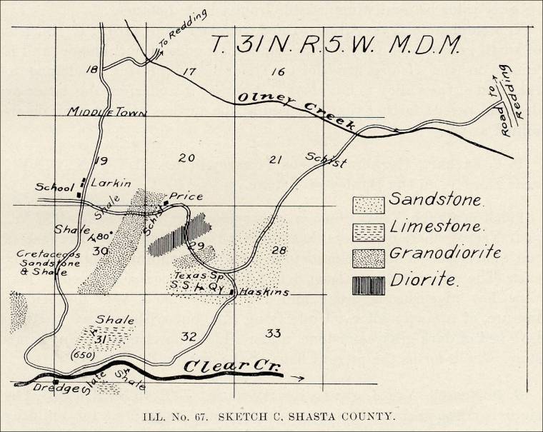
"Texas Spring Quarry, in Sec. 29, T. 31 N., R. 5 W.; California Sandstone and Construction Company, 16 Post street, San Francisco, owner. The Chico sandstone lies at the surface on a considerable portion of Sections 28 and 29 (see sketch C); thin beds are also found overlying the shales in Section 30, on the Horsetown road. At the Texas Spring quarry the sandstone is yellow and hard on the exposed faces; gray and softer when fresh; thickly bedded, dipping slightly a little north of east. One bed more than 7 feet thick was worked in the quarry. The sandstone contains a number of concretions (niggerheads) and very thin lenses, carrying considerable fossils. On account of these inclusions and niggerheads, the stone, otherwise a good building material, is not well suited for that purpose.
Ill. No. 67. Sketch C. Shasta County. 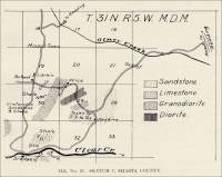
- Shasta County, California – Texas Spring Sandstone Quarry (Sandstone)
(Excerpt from Report XIV of the State Mineralogist - Mines and Mineral
Resources of Portions of California, Chapters of State Mineralogist's Report
- Biennial Period 1913-1914, Part VI. "The Counties of Shasta,
Siskiyou, Trinity," by G. Chester Brown, Field Assistant (field work
in November, 1913), California State Mining Bureau, San Francisco, California,
1916, pp. 746-925.)
"At the Texas Spring Quarry, in Sec. 29, T. 31 N., R. 5 W., owned by California Sandstone and Construction Company of San Francisco, a little work has been done in the past, but the quality is not good on account of the number of niggerheads and fossils contained in the sandstone.
"Bibl.: Bull. No. 38, pp. 138-139."
- Shasta County, California – Texas Spring Sandstone Quarry (Sandstone)
(Excerpt from Report XIV of the State Mineralogist - Mines and Mineral
Resources of Portions of California, Chapters of State Mineralogist's Report
- Biennial Period 1913-1914, Part VI. "The Counties of Shasta,
Siskiyou, Trinity," by G. Chester Brown, Field Assistant (field work
in November, 1913), California State Mining Bureau, San Francisco, California,
1916, pp. 746-925.)
-
Shasta County, California – Tuff Deposit (Tuff) (Excerpt from
Report XIV of the State Mineralogist - Mines and Mineral Resources of
Portions of California, Chapters of State Mineralogist's Report - Biennial
Period 1913-1914, Part VI. "The Counties of Shasta, Siskiyou, Trinity," by G. Chester Brown, Field Assistant (field work in November, 1913), California
State Mining Bureau, San Francisco, California, 1916, pp. 746-925.)
"A belt of tuff extends from Clover Creek to Bear Creek, a distance of 5 miles, in Sec. 18, T. 31 N., R. 2 W.; in the forks of old Cow Creek, and South Cow Creek, a bluff of Tuscan tuff rises with steep sides from 30 to 50 feet high. The tuff has a light gray color and easily cuts to any desired form, but hardens on exposure. Being light, it makes a good building material for a temperate climate.
"Bibl.: Bull. No. 38, p. 161."
"Brock Mountain Deposit. This is the largest outcrop of the Hosselkus (Triassic) limestone, covering half or more of secs. 4, 5, 8, and 9, T. 34 N., R. 2 W., north of Pit River. J. P. Smith (94, p. 606)* published the results of his studies of this limestone in 1894. It is reported to have a total thickness of 200 feet and covers the sides and top of the mountain through a vertical range of over 1000 feet to well over 2500 feet elevation.
(* James Perrin Smith, "The Metamorphic Series of Shasta County, California," Journal of Geology, vol. 2, pp. 588-612, 1894.)
"Smelters at Bully Hill and Afterthought mines used this limestone for flux. It was quarried in section 8 and J. S. Diller (06)* quotes the average partial analysis as showing 51 percent CaO, 1.5 percent Fe2O3 and Al2O3, and 4 percent insoluble, equivalent to less than 93 percent CaCO3. This is considerably lower than the average of analyses given in this report for the Hosselkus limestone. It is hard, rather siliceous and bluish gray. Bones of large reptiles are reported to occur in it, as well as numerous other fossils.
(* J. S. Diller, Description of the Redding Quadrangle, California, U. S. Geological Survey, Geological Atlas, Redding Folio (no. 138), 14 pp., maps, 1906.)
"No work has been done on this deposit since smelting was stopped. An old road formerly connected the quarry with Winthrop and Bully Hill, 5 and 6 miles distant, respectively. The following is a recent analysis of a 'spot' sample from the old quarry face:
SiO2, 1.64 percent
R2O3 (Fe2O3 and Al2O3), 0.29 percent
CaCO3, 96.68 percent
MgCO3, 0.56 percent"Sec. 5 T. 34 N., R. 2 W., is assessed to Southern Pacific Land Company. Sections 4 and 8 are unpatented and section 9 belongs to the United States."
Commercial use of material within this site is strictly prohibited. It is not to be captured, reworked, and placed inside another web site ©. All rights reserved. Peggy B. and George (Pat) Perazzo.