
San Diego - List of Stone Quarries, Etc.*
(* Please note this list does not include sand, gravel, or decomposed granite quarries.)
- Grantville (northeast of), San Diego County, California – the Canyon Rock Company Quarry & Plant (Crushed & Broken Stone) (from Geology and Mineral Resources of San Diego County, County Report 3, by F. Harold Weber, Jr., Geologist, California Division of Mines and Geology, 1963, pp. 237. (Used with permission) (This book is available on the Internet Archive – Texts.)
(pp. 232)
“Two companies – Canyon Rock Company (V. R. Dennis) and K. H. Golden Company – currently produce crushed stone from metavolcanic rocks. Both operators work deposits in the Mission Gorge area, north of Grantville. Canyon Rock Company has operated a quarry in this area since 1929, and now produces both crushed and broken stone. It is the only operator in the county that produces all of the so-called standard sizes of coarse aggregate from metavolcanic rocks (see ‘Aggregate’ in section on ‘Products and Marketing’). All other operators that produce all of the standard sizes of aggregate utilize the constituents of the Poway conglomerate. Canyon Rock Company works its quarry by benching, using blast holes drilled as deep as 150 feet with wagon drills (Photo 75). The quarried stone is processed by use of a primary jaw crusher, screens, secondary jaw crusher, classifiers, cone crushers, log washers, and final classifiers. Plant capacity is about 200 tons per hour. K. H. Golden Co. Inc., produces three sizes of crushed stone for use as aggregate in bituminous concrete.”
“Photo 75. Canyon Rock Company operation of V. R. Dennis at Mission Gorge; view southwest. Company produces sand from bed of San Diego River (left background) and crushed stone from massive metavolcanic rocks shown in quarry walls. Mission Valley is at left in distant background.” 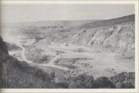
(pp. 237)
(Map No.) 373a (plant) 373 b (quarry); (Company and Operations – or Deposit) Dennis, V. R., P.O. Box 3158, San Diego 3. Canyon Rock Co. (Plant and Quarry); (Location) Sec. 3, T. 16 S., R. 2 W., S.B.. (proj); portion Blocks 61, 62, and 63, Mission Lands; about 2 miles northeast of Grantville, in Mission Gorge area.; (Status) active (1959); (History) Started at present location in 1929. (Geology) Massive metavolcanic rocks of Santiago Peak series. (Size of Excavation) Quarry 750-ft. long, 160-ft. high. (Products) Crushed stone (all standard sizes of rock for use as aggregate) and broken stone for use as riprap (up to 6 and 7 tons). Concrete sand.
(Mining, Processing, References, and Other Data) “Nine-inch churn drill holes 150 feet deep, loaded with 40% powder; 20% secondary blasting. Loaded by 1 ½- or 2-yard shovel into 20-yard pit trucks. Haul 1/3 mile to surge pile. Through 40-inch X 48-inch jaw crusher to stockpile. Screened to plus 2 ½ inches, and this through 18-inch X 36-inch double jaw crusher; minus 2 ½-inch classified to ¾-inch minus. Oversize to 4-foot Symons fine bowl crusher; minus through log washer, classified and stockpiled. Sand from pit (see below) fed in at this point (after log washer). Sand through screw washer and stockpiled. Material loaded into trucks for transport by skiploader. Hourly capacity 200 tons; 40 employees (25 in plant and quarry, 2 at sand operation). Have soil pit on property for blending with rock to make concrete road base. Stone weighs 138 pounds per cubic foot. Water from ponds – 700 gallons per minute into plant. (Tucker and Reed 39:49).” (To see the bibliography that lists the books cited in the previous sentence, see the “Annotated Bibliographies” section of Geology and Mineral Resources of San Diego County, pp. 283-309.)
- Grantville (northeast of), San Diego County, California – the Fletcher Quarries – Ed Fletcher Co. (Crushed Stone) (from Geology and Mineral Resources of San Diego County, County Report 3, by F. Harold Weber, Jr., Geologist, California Division of Mines and Geology, 1963, pp. 243. (Used with permission) (This book is available on the Internet Archive – Texts.)
(pp. 231)
“During the mid- and late-1950’s two deposits of granitic rocks were quarried for riprap, both by the J. R. Stringfellow Company, of Riverside. These deposits are the Marron Quarry, near Oceanside; and the Meadowlark Ranch Quarry, north of Rancho Santa Fe. The former quarry was operated only for a short period in the mid-1950’s because it yielded fragments only as large as 10 tons, and the operator needed 20-ton fragments for construction of a jetty. The Meadowlark Ranch Quarry, which was opened in 1957 to replace the Marron quarry, yields fragments that range from five pounds to 20 tons.”
(pp. 233)
“In 1957, nearly 250,000 tons of riprap, valued at almost $1,000,000, was produced in San Diego County (San Diego County Division of Natural Resources, 1957, p. 20). During that year at least 95 percent of the stone produced was used in the Mission Bay Park Project to construct jetties and to cap or line the sides of man-made islands.
“Fragment size and classification of stone used for riprap generally are different for each job. Classes A and B stone used for shore facing in the Mission Bay Park Project range in size as follows: Class A, 1 pound to 1 ½ tons; Class B, 1 pound to 3 tons; with specified percentages of sizes within the general classes. Blocks to face the Mission Park jetty ranged from 7 to 20 tons; the core of the jetty was constructed of quarry-run material, with the largest pieces as heavy as five tons.
“During the 1950’s, riprap also was used in San Diego County in construction of the 10th Avenue mole pier; the San Diego River Flood Control Project; Sutherland Dam north of Ramona; and in naval seafront projects. In 1957, J. R. Stringfellow Company, of Riverside, was the principal producer of riprap in the county.”
(pp. 243)
(Map No.) 382a; (Company and Operations – or Deposit) Fletcher Quarries, Ed Fletcher Co., 2340 Fletcher Way, El Cajon; (Location) W. ½ Sec. 35, T. 15 S., R. 2 W., SBM (proj); Lot D and portion Lot C, Block 70, Referee partition, Rho Mission; about 3 ½ miles northeast of Grantville in Mission Gorge; (Status) Active intermittently (1959); (History) Operated since 1947 by various contractors, most recently by J. R. Stringfellow, Riverside. (Geology) Mainly metavolcanic rocks of Black Mountain series; some granitic rocks of Cretaceous age in northeast part of property (Size of Excavation) Five large quarries which average 550 ft. long and 100 ft. wide (1958) (Products) Broken stone, 50 pounds to 15 tons, used as riprap.
(Mining, Processing, References, and Other Data) “Use various quarry methods. Some coyote hole blasting for recovery of large fragments. Also use churn drill benching and blasting. Stone loaded onto trucks for transport with shovel or dragline and skips. Most of the rock produced here used in Mission Bay Park project for construction during 1956-57 of three jetties and the 10th avenue mole pier.”
(Map No.) 382b; (Company and Operations – or Deposit) DG pit; (Location) SE. ¼ SE. ¼ Sec. 15, T. 14 S., R. 2 W., SBM; about 2 miles west of Poway, on north side of Los Penasquitos Canyon; (Status) inactive since 1948; (History) (blank) (Geology) Partly decomposed granitic rocks (Size of Excavation) blank (Products) Decomposed granite (DG).
- Grantville (northwest of), San Diego County, California – the Golden Quarry – Kenneth H. Golden Co., Inc. (Crushed Rock) (from Geology and Mineral Resources of San Diego County, County Report 3, by F. Harold Weber, Jr., Geologist, California Division of Mines and Geology, 1963. (Used with permission.) (Used with permission) (This book is available on the Internet Archive – Texts.)
(pp. 232)
“Two companies – Canyon Rock Company (V. R. Dennis) and K. H. Golden Company – currently produce crushed stone from metavolcanic rocks. Both operators work deposits in the Mission Gorge area, north of Grantville. Canyon Rock Company has operated a quarry in this area since 1929, and now produces both crushed and broken stone. It is the only operator in the county that produces all of the so-called standard sizes of coarse aggregate from metavolcanic rocks (see ‘Aggregate’ in section on ‘Products and Marketing’). All other operators that produce all of the standard sizes of aggregate utilize the constituents of the Poway conglomerate. Canyon Rock Company works its quarry by benching, using blast holes drilled as deep as 150 feet with wagon drills (Photo 75). The quarried stone is processed by use of a primary jaw crusher, screens, secondary jaw crusher, classifiers, cone crushers, log washers, and final classifiers. Plant capacity is about 200 tons per hour. K. H. Golden Co. Inc., produces three sizes of crushed stone for use as aggregate in bituminous concrete.”
“Photo 75. Canyon Rock Company operation of V. R. Dennis at Mission Gorge; view southwest. Company produces sand from bed of San Diego River (left background) and crushed stone from massive metavolcanic rocks shown in quarry walls. Mission Valley is at left in distant background.” (pp. 243)
(Map No.) 384; (Company and Operations – or Deposit) Golden, Kenneth H., Co., Inc., 1367 Sixth Ave., San Diego 1; (Location) South edge SW. ¼ Sec. 35, T. 15 S., R. 2 W., SBM (proj); about 3 miles northwest of Grantville, in Mission Gorge area; (Status) Active (1959); (History) Started 1953 (Geology) Metavolcanic rocks of Black Mountain series. Have adjoining decomposed granite it not being operated in 1957 (Size of Excavation) 40 acres (Products) Crushed stone (stockpile 3 sizes, all to blacktop plant: 0-4 mesh; 4 plus to ½-in.; ½- to ¾-in.). Also produce cement-treated road base.
(Mining, Processing, References, and Other Data) “Wagon drill, shoot, and shove with dozer to 26-in. grizzly. Use breaking ball on quarry oversize. From grizzly to 30-in. X 42-in. jaw crusher; conveyor to 18-in. X 30-in. jaw, to 3-ft. standard Symons, to 4-ft. X 14-ft. screen. Oversize ¾-in. rock to 3-ft. short head Symons crusher and return through screen to stock pile, over tunnel. Conveyors to hot plant. Hourly capacity 100 tons; 4 employees. Buy D. G. from outside. Water from well 800-ft. deep.”
- Grantville (west-southwest of), San Diego County, California – the Mission Valley Operation (Plant & Quarry) (Crushed Rock/Aggregate) (from Geology and Mineral Resources of San Diego County, County Report 3, by F. Harold Weber, Jr., Geologist, California Division of Mines and Geology, 1963, pp. 241. (Used with permission) (This book is available on the Internet Archive – Texts.)
http://archive.org/details/geologyandminer03webe(Map No.) 381a, 381b, 381c; (Company and Operations – or Deposit) Mission Valley operation: Plant, Sand and gravel source; Sand source; (Location) Sec. 18, T. 16 S., R. 2 W., SBM (proj.); partition of Lot 36, Rancho Mission; about 2 miles west-southwest of Grantville, on north side of Mission Valley; (Status) Active (1959); (History) Started 1940 (Geology) Poway conglomerate and San Diego River bed (Size of Excavation) 75 acres (Products) Concrete sand and crushed gravel (standard sizes rock for use as aggregate)”
(Mining, Processing, References, and Other Data) “Quarry-like working in steep-walled canyon. Bench, drill, and shoot conglomerate; 1 ½–yd. shovel loads on pit trucks which dump on edge of cliff from where dozer shoves material over, and in front of hydraulic monitor below. Monitor (200 g.p.m., 200 lb. pressure) breaks up clay balls and washes away most fines. Then material picked up with dragline, trucked in 16-ton pit trucks ¼ mile to plant. Dumped through 12-in. grizzly to 15-in. X 28-in. jaw crusher, then to scrubber and screens. Oversize to gyrator crusher, rest to Symons crusher. Washed, screened, stockpiled. Some crushed gravel screened for various sized products used in adjoining branch of Pre-Mixed Concrete Co. Sand from river bed loaded into 12-ton pit trucks by ¾-yd. dragline, trucked ¼ mile to pant. At plant sand is fed into sand washer, screened, stockpiled. Hourly capacity 175 tons; 44 employees.” (To see the bibliography that lists the books cited in the previous sentence, see the “Annotated Bibliographies” section of Geology and Mineral Resources of San Diego County, pp. 283-309.)
- Grantville (northeast of), San Diego County, California – the Monarch Materials Co. (Crushed Gravel) (from Geology and Mineral Resources of San Diego County, County Report 3, by F. Harold Weber, Jr., Geologist, California Division of Mines and Geology, 1963, pp. 242. (Used with permission) (This book is available on the Internet Archive – Texts.)
(Map No.) 381h; (Company and Operations – or Deposit) Monarch Materials Co.; (Location) Plant: NE. ¼ Sec. 25, T. 15 S., R. 1 W., SBM (proj); about 4 miles northeast of Grantville, just northeast of the head of Mission Gorge; (Status) Active (1959); (History) Started 1954 (Geology) (blank) (Size of Excavation) 200 acres (total) (Products) Concrete and plaster sand and crushed gravel (standard sizes of rock for aggregate).
(Mining, Processing, References, and Other Data) “See below.”
(Map No.) 381i; (Company and Operations – or Deposit) (Monarch Materials Co.) Source of both sand and gravel; (Location) S. ½ Sec. 20, T. 15 S., R. 1 W., SBM (proj); about 2 miles east-northeast of plant; (Status) (blank); (History) (blank) (Geology) Alluvium and dissected alluvium derived mainly from Poway conglomerate (60% gravel, 40% sand) (Size of Excavation) (blank) (Products) “See above.”.
(Mining, Processing, References, and Other Data) “Work deposit to water level (blue clay just below, at 15 feet). 2 ½-yard dragline to 10-yard pit trucks. Haul 2 miles to plant. At plant material dumped onto 12-inch grizzly, then to hopper, and to 15-inch X 38-inch jaw crusher. Then to 4-feet X 12-feet screen, and initial wash. Oversize to 3-foot standard size Symons crusher, then to final screen and wash. Then to Symons in closed circuit. Sand from river bed deposit constitutes principal source of sand. Hourly capacity 200 tons; 19 employees. McCoy Redi-Mix buys gravel, but has own source of sand.” (To see the bibliography that lists the books cited in the previous sentence, see the “Annotated Bibliographies” section of Geology and Mineral Resources of San Diego County, pp. 283-309.)
- Grossmont District, San Diego County, California – John Grant
(Stone Quarry) (From Commercial
'Black Granite' of San Diego County, California, Special Report 3,
by Richard A. Hoppin and L. A. Norman, Jr., State of California, Department
of Natural Resources, Division of Mines, San Francisco, December 1950.")
This quarry was located in the Grossmont District of San Diego County. First year of production was 1913, last year of production was 1915.
- Grossmont District, San Diego County, California – the John Grant Quarry (Granite/dimension stone) (from Geology and Mineral Resources of San Diego County, County Report 3, by F. Harold Weber, Jr., Geologist, California Division of Mines and Geology, 1963, pp. 263. (This book is available on the Internet Archive – Texts.)
(Remarks and references) “Worked deposits in Grossmont, Santee, and Lakeside-Foster areas in 1910’s. Produced gray stone. See also Waterman Granite Co. quarry. (Hoppin and Norman 50:7).” (To see the bibliography that lists the books cited in the previous sentence, see the “Annotated Bibliographies” section of Geology and Mineral Resources of San Diego County, pp. 283-309.)
- Grossmont District, San Diego County, California – the John Grant Quarry (Granite/dimension stone) (from Geology and Mineral Resources of San Diego County, County Report 3, by F. Harold Weber, Jr., Geologist, California Division of Mines and Geology, 1963, pp. 263. (This book is available on the Internet Archive – Texts.)
- Grossmont-La Mesa District, San Diego County, California – Charles
G. Moore (Stone Quarry) Operated by. (From Commercial 'Black
Granite' of San Diego County, California, Special Report 3, by
Richard A. Hoppin and L. A. Norman, Jr., State of California, Department
of Natural Resources, Division of Mines, San Francisco, December 1950.")
Located in the Grossmont-La Mesa District of San Diego County, produced a gray stone. First year of production was 1908 (?), last year of production is unknown.
- Grossmont Station (south of), San Diego County, California – the Pacific Electric Railway Company Quarry (Granite/dimension stone) (from Geology and Mineral Resources of San Diego County, County Report 3, by F. Harold Weber, Jr., Geologist, California Division of Mines and Geology, 1963, pp. 265. (This book is available on the Internet Archive – Texts.)
(Map No.)* (blank); (Name of claim, mine, or group) Pacific Electric Railway Co.; (Location) “South of Grossmont Station” (Merrill, 1914);* (Owner name, address) E. Fletcher (1914); (Geology) Gray granitic rocks. (* You can find the location of this quarry on Plate 10 near the end of the book at the link above. This map covers the Lakeside-Foster, the Escondido, and Vista areas of San Diego County.)
(Remarks and references) “Small quarry operated in 1910’s for stone used as paving blocks. (Merrill 14:673.” (To see the bibliography that lists the books cited in the previous sentence, see the “Annotated Bibliographies” section of Geology and Mineral Resources of San Diego County, pp. 283-309.)
- Grossmont District, San Diego County, California – San Diego
Granite Works (Stone Quarry) (From Commercial
'Black Granite' of San Diego County, California, Special Report 3,
by Richard A. Hoppin and L. A. Norman, Jr., State of California, Department
of Natural Resources, Division of Mines, San Francisco, December 1950.")
Located in the Grossmont District of San Diego County, produced a gray stone. First year of production was 1912 (?), last year of production is unknown.
- Grossmont District, San Diego County, California – the San Diego Granite Works Quarry (Granite/dimension stone) (from Geology and Mineral Resources of San Diego County, County Report 3, by F. Harold Weber, Jr., Geologist, California Division of Mines and Geology, 1963, pp. 265. (This book is available on the Internet Archive – Texts.)
(Map No.) (blank); (Name of claim, mine, or group) San Diego Granite Works quarry; (Location) “Near Mt. Helix, one quarter mile east of Hotel Grossmont” (Merrill, 1914); (Owner name, address) Fred Frickas, San Diego Granite Works, 11th and M. Sts., San Diego (1914); (Geology) Light-gray granitic rocks.
(Remarks and references) “Operated for a short period starting in 1912. Company also operated C. G. Moore quarry (which see) for a short time. In 1914 company was processing stone from the Simpson-Pirnie quarry near Lakeside. (Hoppin and Norman 50: 7; Merrill 14:672).” (To see the bibliography that lists the books cited in the previous sentence, see the “Annotated Bibliographies” section of Geology and Mineral Resources of San Diego County, pp. 283-309.)
- Grossmont District, San Diego County, California – the San Diego Granite Works Quarry (Granite/dimension stone) (from Geology and Mineral Resources of San Diego County, County Report 3, by F. Harold Weber, Jr., Geologist, California Division of Mines and Geology, 1963, pp. 265. (This book is available on the Internet Archive – Texts.)
- Grossmont Station, San Diego County, California – E. Fletcher
(Granite Quarry) (Hornblende, Biotite Granite) (Excerpt from Report
XIV of the State Mineralogist - Mines and Mineral Resources of Portions
of California, Chapters of State Mineralogist's Report - Biennial Period
1913-1914, Part V. "The Counties of San Diego, Imperial,"
by Frederick J. H. Merrill, Ph.D., Field Assistant (field work in December,
1914), California State Mining Bureau, San Francisco, California, 1916,
pp. 427-634.)
"South of Grossmont station is a small quarry on land owned by E. Fletcher, of San Diego, and operated by the Pacific Electric Railway Company for paving blocks. The rock is a hornblende, biotite granite and cleaves into rectangular blocks of great regularity."
"Dr. A. S. Eakle's determination of (this rock) is as follows:….
"Pacific Electric Railway Company. Grossmont. Light gray hornblende-biotite-granite. A thin section shows much plagioclase and orthoclase, large plates of biotite and hornblende and some magnetite."
- Harmony (near), San Diego County, California - the Ebony Black Diamond Granite Co. Quarry (Stockdale Granite quarry) (Granite/dimension stone)
See: “Escondido (north-northeast of), San Diego County, California – the Ebony Black Diamond Granite Co. Quarry (Stockdale Granite quarry) (Granite/dimension stone)”
- Harmony (near), San Diego County, California – the Escondido Quarries, Inc. (Pacific Cut Stone and Granite Co.) Quarry (Granite/dimension stone)
See: “Escondido, San Diego County, California – the Escondido Quarries, Inc. (Pacific Cut Stone and Granite Co.) Quarry (Granite/dimension stone)”
- Harmony (near), San Diego County, California – the Don Potts Quarry (Granite/dimension stone)
See “Escondido (southwest of), San Diego County, California – the Don Potts Quarry (Granite/dimension stone)”
- Harmony Grove (near), San Diego County, California – the John Stridsberg Quarries (Granite/dimension stone) (from Geology and Mineral Resources of San Diego County, County Report 3, by F. Harold Weber, Jr., Geologist, California Division of Mines and Geology, 1963. (This book is available on the Internet Archive – Texts.)
(pp. 259)
“Escondido Area (Black Granite). Seven quarries are clustered in an area of slightly more than one quarter square mile which is about 3 ½ miles southwest of Escondido. The quarries are on the north and south slopes of a short, narrow canyon which cuts a narrow, north-trending hill composed of San Marcos gabbro. The deposits quarried in the area consist of large residual boulders of fine- to medium-grained, dark gray to dark bluish-gray gabbro (Photo 82). Stone from these deposits is used for building, monuments, and surface plates.
“The first quarry in the area was opened by John Stridsberg who worked this, and later one other quarry, from 1923 until his death in 1952. Three quarries were active in mid-1958. One of these was the largest granite quarry in the county, which was being operated by Escondido Quarries, Inc. (see description below). The other two active quarries were being worked by the Valley Granite Company.”
(pp. 266)(Map No.)* 436a & 436b; (Name of claim, mine, or group) Stridsberg, John quarries; (Location) Operated two quarries near Harmony Gove about 3 miles west-southwest of Escondido: (436a) Superior Black quarry: north edge NE ¼ sec. 31, T12S, R2W, SBM & (436b) Crystal Black quarry: near the center of the west edge of the SE ¼ sec. 30, T12S, R2W, SBM;* (Owner name, address) (436a) Superior Black quarry: undetermined (1958) & (436b) Crystal Black quarry: sold to Escondido Quarries, Inc. (1958); (Geology) Dark-gray granitic rocks (San Marcos gabbro) which comprise residual boulders. (* You can find the location of this quarry on Plate 10 near the end of the book at the link above. This map covers the Lakeside-Foster, the Escondido, and Vista areas of San Diego County.)
(Remarks and references) “Started in 1923. Operated continuously from 1926 to 1952 when operator died. First produced ‘Superior black granite,’ then ‘Crystal black granite.’ Last operated Crystal black quarry. Produced monument stones. (Hoppin and Norman 50:4, 6, 7, 11).” (To see the bibliography that lists the books cited in the previous sentence, see the “Annotated Bibliographies” section of Geology and Mineral Resources of San Diego County, pp. 283-309.)
- Harmony (near), San Diego County, California - the Valley Granite Co. Quarries (Granite/dimension stone)
See: “Escondido (west-southwest of), San Diego County, California – the Valley Granite Co. Quarries (Granite/dimension stone)”
- Jacumba (near), San Diego County, California - L. A. Blockman –
Marble Deposit (Marble) (Excerpt from Report XIV of the State Mineralogist
- Mines and Mineral Resources of Portions of California, Chapters of State
Mineralogist's Report - Biennial Period 1913-1914, Part V. "The
Counties of San Diego, Imperial," by Frederick J. H. Merrill, Ph.D.,
Field Assistant (field work in December, 1914), California State Mining
Bureau, San Francisco, California, 1916, pp. 427-634.)
"Near Jacumba, Sec. 2, T. 18 S., R. 8 E., is a dark gray marble on which some claims were located by Mr. L. A. Blockman, of San Diego."
- San Diego County, California – Blockman Marble deposit (Marble)
(Excerpt from "Limestone in California," by Clarence A. Logan,
California Journal of Mines and Geology, Vol. 43, No. 3, July
1947, California Division of Mines, San Francisco, California, pp.
175-357. Used with permission, California Department of Conservation,
California Geological Survey.)
"Blockman marble deposit is in sec. 2, T. 18 S., R. 8 E., S.B., in the southeast corner of the county 4 ½ miles east by good road from the San Diego & Arizona Railroad. It is a dark gray marble. There is no record of development."
- Jacumba (east of), San Diego County, California – the Blockman Quarry (Limestone) (from Geology and Mineral Resources of San Diego County, County Report 3, by F. Harold Weber, Jr., Geologist, California Division of Mines and Geology, 1963, pp. 182. (Used with permission) (This book is available on the Internet Archive – Texts.)
(pp. 181, 185)
White Cap (Blackman) Deposit
“Location: W. ½ Sec. 11, T. 18 S., R. 8 E., S.B.M., about three miles due east of Jacumba, adjacent to the Mexican border. Ownership: Bryan H. Hathaway, 4567 Florida St., San Diego 16, holds one unpatented 20-acre placer claim (1958).
“The White Cap Claim covers a small deposit of limestone which crops out of nearly flat terrain. Although the claim was located in the early 1940’s, the deposit has been known for many years and was discussed briefly by Tucker (1925, p. 372). Crushed stone, for use as roofing granules and poultry grit, has been produced from white rock in the deposit by J. H. Hubble, Jacumba, during the mid-1940’s and by Don Weaver, Jacumba, in 1951. Weaver selectively mined about 1,000 tons of white magnesian limestone which was ground to minus three-eighths inch, plus 10-mesh in a crude mill on the property. The mill was nearly intact in March 1957. Its capacity is about five tons per hour.
“This deposit consists of a lens of crystalline magnesian limestone, with minor proportions of tactite, in schist. The lens strikes N. 30º W. and dips 60 º to 75 º west. It is between 500 and 600 feet in length and between 100 and 150 feet in maximum width. The limestone ranges from pure white, through white with speckled-gray bands, to pale gray. The tactite is an alteration of silica-rich strata in the limestone. It is gray-green, very fine grained, and composed mainly of diopside, red-brown garnet, and minor quartz. These rocks have been cut by small bodies of quartz diorite.
The following average composition was calculated from analyses of four random-type samples collected by O. E. Bowen, Jr., of the Division of Mines and Geology from this deposit (analyses by Abbott Hanks, Inc., San Francisco in June 1955): SiO2, 0.64 percent; Fe3O4, 0.11 percent, Al2O3, 0.35 percent; CaO, 38.36 percent; Mgo, 14.28 percent; and P2O5, trace.
“Development consists of several shallow cuts and trenches.”
(pp. 182)
(Remarks and references) “See White Cap deposit in text. (Logan 47:301).” (To see the bibliography that lists the books cited in the previous sentence, see the “Annotated Bibliographies” section of Geology and Mineral Resources of San Diego County, pp. 283-309.)
- San Diego County, California – Blockman Marble deposit (Marble)
(Excerpt from "Limestone in California," by Clarence A. Logan,
California Journal of Mines and Geology, Vol. 43, No. 3, July
1947, California Division of Mines, San Francisco, California, pp.
175-357. Used with permission, California Department of Conservation,
California Geological Survey.)
- Jacumba (northeast of), San Diego County, California – the Weaver Quarry (Crushed Stone) (from Geology and Mineral Resources of San Diego County, County Report 3, by F. Harold Weber, Jr., Geologist, California Division of Mines and Geology, 1963, pp. 250-251. (Used with permission.) (This book is available on the Internet Archive – Texts.)
(Map No.) 409; (Company and Operations – or Deposit) Weaver deposit, Don Weaver, Jacumba; (Location) Center N. ½ N. ½ Sec. 35, T. 17 S., R. 8 E., SBM; on the east edge of Table Mt., about 4 miles northeast of Jacumba; (Status) Active (1958); (History) First developed in 1940’s as possible source of aggregate for concrete blocks. Since 1953, present operator has worked intermittently (Geology) Deposit of grayish pink to brick-red volcanic cinders (or lapilli tuff) in alternating fine- and coarse-grained layers. Fine-grained layers predominate…felsite from less than 1/8-inch to 1 inch in size. Coarse-grained layers contain fragments commonly 1/2-inch to 6 inches. Calcite and chalcedony coat fragments. (Size of Excavation) Pit, nearly circular in plan, 100 feet in diameter and as deep (Products) Crushed stone for roofing granules (about 1/8-inch).
(Mining, Processing, References, and Other Data) “First developed as source of concrete aggregate by Hazard Bloc Company, but proved too reactive. Material mined with D-8 tractor with ripper attached. Sixty percent at size before milling. Operator uses portable screens and crusher, used also at deposit in Imperial Co. About 20,000 tons of stone produced from this deposit between 1953 and 1957. In addition to this deposit, J. H. Hubble, and later Don Weaver, worked a deposit of andesite lava adjacent to Mexico border, southwest of White Cap limestone deposit, in the SW ¼ Sec. 11, T, 18 S., R. 8 E., SBM.” (To see the bibliography that lists the books cited in the previous sentence, see the “Annotated Bibliographies” section of Geology and Mineral Resources of San Diego County, pp. 283-309.)
- Jacumba (east of), San Diego County, California – the White Cap Limestone Deposit (Limestone) (from Geology and Mineral Resources of San Diego County, County Report 3, by F. Harold Weber, Jr., Geologist, California Division of Mines and Geology, 1963. (Used with permission) (This book is available on the Internet Archive – Texts.)
“…The White Cap Deposit, east of Jacumba, consists of magnesium limestone, and also has been worked as a source of roofing granules….”
Also see, “Jacumba (east of), San Diego County, California – the Blockman Quarry (Limestone)” above.
- Julian (near), San Diego County, California – Marble Deposit (Marble) (from Mineral Resources of the United States Calendar Year 1888, David T. Day, Chief of Division of Mining Statistics and Technology, Department of the Interior, United States Geological Survey, 1890, pp. 542-543)
- Julian (west of), San Diego County, California – the Foster Quarry (Crushed Stone) (from Geology and Mineral Resources of San Diego County, County Report 3, by F. Harold Weber, Jr., Geologist, California Division of Mines and Geology, 1963, pp. 243. (Used with permission) (This book is available on the Internet Archive – Texts.)

“California…Near Julian, in San Diego county, an immense ledge of white marble has been discovered. As soon as railroad facilities have been completed and the operations are underway, it is expected that quarrying operations will be commenced. Another ledge of marble has also been discovered in the San Gabriel mountains, in Los Angeles county. The location is such that quarrying operations can be conducted without great cost.”
- Jamul, San Diego County, California – Jamul
Cement
See: San Diego (southeasterly of), San Diego County, California – Jamul Cement
- La Cresta (northeast of), San Diego County, California – the Red Rose Quarry (Quartzite) (from Geology and Mineral Resources of San Diego County, County Report 3, by F. Harold Weber, Jr., Geologist, California Division of Mines and Geology, 1963, pp. 261-262. (Used with permission) (This book is available on the Internet Archive – Texts.)
Red Rose Quarry
“Location: S. ½ SW. ¼ Sec. 35, T 15 S., R. 1 E., S.B.M.; about three-fourths of one mile northeast of La Cresta. Ownership: A. Carlsen, 625 La Cresta Heights Road, El Cajon (1958).
“Small tonnages of stone quarried at this deposit are marketed as rubble in the San Diego area under the name ‘Red Rose Quartzite’ (Goldman, 1957, p. 602). The stone is used mainly in walls and as facing.
“The deposit consists of red, iron-oxide stained quartzite which occurs as a pendant in granitic rocks (Goldman, 1957). The rock is massive, with steeply dipping joint planes. The blocks are blasted, pried loose, then split with plugs and feathers. In 1958, the quarry face was about 250 feet long, and 30 feet high at its highest point; the quarry floor was 100 feet wide at its widest point.”
- La Jolla (northeast of), San Diego County, California – the Carrol Canyon Operation (Crushed Rock) (from Geology and Mineral Resources of San Diego County, County Report 3, by F. Harold Weber, Jr., Geologist, California Division of Mines and Geology, 1963, pp. 237. (Used with permission) (This book is available on the Internet Archive – Texts.)
(Map No.) 369c; (Company and Operations – or Deposit) Carroll Canyon operation; (Location) Portion secs. 1 and 2, T. 15 S., R. 3 W., and sec. 6, T. 15 S., R. 2 W., S.B.M.; 8 miles northeast of La Jolla; (Status) Active (1959); (History) Started 1953 (Geology) Alluvium in Carrol Canyon derived from Poway conglomerate (Size of Excavation) 10 acres (Products) Crushed gravel for use as road base (1 ½ inches minus, and ¾-inch minus).
(Mining, Processing, References, and Other Data) “One yard shovel to carryalls to plant. Dump on 12-inch grizzly. Dry process. Through 20-inch X 36-inch jaw crusher to Traylor gyratory to 20-inch X 54-inch rolls. Conveyor to bunker. Electric power for plant from 75-kw generator except for the gyratory crusher (one GMC diesel) and the rolls (2 GMC diesels). Hourly capacity 120 tons, 5…One yard shovel to 20 ton bottom dump truck and trailer. Haul 3 miles to plant (4 trucks operating in 1958). Dump on stockpile. Dozer pushes on 14-inch grizzly. Trommel scrubber removes sand. Then the 16 inch X 38-inch jaw crusher. Then through log washer to 3-foot Symons cone crusher to sizing screens. Use 16-inch X 30-inch rolls to balance sizes. In 1958 installed extra washing units to handle hillside deposits. Hourly capacity 150 tons; 11 employees. Water from well and holding basin.” (To see the bibliography that lists the books cited in the previous sentence, see the “Annotated Bibliographies” section of Geology and Mineral Resources of San Diego County, pp. 283-309.)
- La Mesa (east of), San Diego County, California – Charles G.
Moore (Granite Quarry) (Diorite) (Excerpt from Report XIV of the
State Mineralogist - Mines and Mineral Resources of Portions of California,
Chapters of State Mineralogist's Report - Biennial Period 1913-1914,
Part V. "The Counties of San Diego, Imperial," by
Frederick J. H. Merrill, Ph.D., Field Assistant (field work in December,
1914), California State Mining Bureau, San Francisco, California, 1916,
pp. 427-634.)
"Charles G. Moore, 2336 Superba street, San Diego. This quarry, which has been in operation about five years, is east of La Mesa, in the east 370 feet of the S. ½ of the SE. ¼ of the SW. ¼ of the SE. ¼ of Sec. 17, T. 16 S., R. 1 W. This stone, which is a diorite, is wholly used for monumental purposes and about 8 carloads of 200 cubic feet are consumed annually."
"Dr. A. S. Eakle's determination of (this rock) is as follows:….
"Moore, La Mesa. Diorite. A thin section shows plagioclase predominating, a little orthoclase, biotite and hornblende in about equal amounts, some apatite needles and magnetite grains. An occasional augite crystal occurs."
"San Diego Granite Works, corner Eleventh and M streets, San Diego, Fred Fickas, proprietor…at one time operated the quarry near La Mesa, now controlled by Charles G. Moore…."
- La Mesa, San Diego County, California – the Charles G. Moore Quarry (Granite/dimension stone) (from Geology and Mineral Resources of San Diego County, County Report 3, by F. Harold Weber, Jr., Geologist, California Division of Mines and Geology, 1963. (This book is available on the Internet Archive – Texts.)
(pp. 261)
“Grossmont – La Mesa Area (Gray Granite). Two quarries were operated during the early 1900’s in the La Mesa – Grossmont area: These are the Charles Moore Quarry which was operated from 1908 to 1913 and the Pacific Electric Company Quarry which was operated during the 1910’s. Output from the latter operation was used only as paving blocks.”
(pp. 265)(Map No.) (blank); (Name of claim, mine, or group) (Charles G.) Moore quarry; (Location) S ½ SE ¼ SW1/4 SE ¼ sec. 17, T16S, R1W, SBM; in La Mesa, adjacent to eastern city limit, and about ¼ mile south of U. S. Highway 80.;* (Owner name, address) Residential property (1958); (Geology) Diorite. (* You can find the location of this quarry on Plate 10 near the end of the book at the link above. This map covers the Lakeside-Foster, the Escondido, and Vista areas of San Diego County.)
(Remarks and references) “The operator produced about 8 carloads of stone annually from the quarry from an undetermined period starting in 1908 and continuing in 1913. The stone was marketed for use as monuments. See also San Diego Granite Works. (Hoppin and Norman 50:7; Merrill 14:672, 673.” (To see the bibliography that lists the books cited in the previous sentence, see the “Annotated Bibliographies” section of Geology and Mineral Resources of San Diego County, pp. 283-309.)
- La Mesa, San Diego County, California – the Charles G. Moore Quarry (Granite/dimension stone) (from Geology and Mineral Resources of San Diego County, County Report 3, by F. Harold Weber, Jr., Geologist, California Division of Mines and Geology, 1963. (This book is available on the Internet Archive – Texts.)
(Map No.) 383; (Company and Operations – or Deposit) Foster quarry; (Location) South edge SE. ¼ Sec. 35, T. 12 S., R. 3 E., SBM; about 2 ¼ miles west of Julian, north of State Highway 78; (Status) Inactive (1957); (History) Operated briefly during mid-1950’s by A. G. Foster, Julian (Geology) Granitic rocks* (Size of Excavation) Small quarry (Products) Crushed stone used for road base.
(Mining, Processing, References, and Other Data) (blank.)
Commercial use of material within this site is strictly prohibited. It is not to be captured, reworked, and placed inside another web site ©. All rights reserved. Peggy B. and George (Pat) Perazzo.