
Kern County - List of Stone Quarries, Etc.*
(* Please note this list does not include sand or gravel quarries.)
(Please note: In the book entitled, “Mineral Resources of Kern County, California,” by W. B. Tucker, R. J. Sampson, and G. B. Oakeshott, California Journal of Mines and Geology, pp. Vol. 45, No. 2, April 1949, in the "Tabulated list of mines in Kern County" the locations of the quarries/mines are not specified except to give the township/range coordinates. Due to this, I have put all of the quarries identified in this manner in this book - and not known to be in specific locations - listed under "Kern County" in the list of quarries below.)
- Cinco (west of), Kern County, California – Tardy
Limestone Deposit (Limestone) (Excerpt from “Limestone in California,”
by Clarence A. Logan, California Journal of Mines and Geology,
Vol. 43, No. 3, July 1947, California Division of Mines, San Francisco,
California, pp. 175-357. Used with permission, California Department of
Conservation, California Geological Survey.)
“Tardy limestone deposit is 3 miles west of Cinco, a point on the Southern Pacific Railroad 17 miles northeast of Mojave. This is near the Garlock fault, at the extreme southeast side of the Sierra Nevada granitic area.”
- Isabella (east of), Kern County, California – South
Fork Valley Limestone Deposits (Limestone & Marble) (Excerpt from
"Limestone in California," by Clarence A. Logan, California
Journal of Mines and Geology, Vol. 43, No. 3, July 1947, California
Division of Mines, San Francisco, California, pp. 175-357. Used with permission,
California Department of Conservation, California Geological Survey.)
"South Fork Valley extends east from Isabella, where the South Fork joins the main Kern River. From a point on the South Fork about 4 miles east of Isabella, limestone outcrops within half a mile on the north and 1 mile south of the stream. On the north, limestone extends 3 miles northwest, and to the south the interrupted outcrops can be followed southeastward for nearly 10 miles. These deposits are 35 to 45 miles by road from the nearest railroad point at Caliente and have never been developed. The limestone is associated with mica schist, phyllite, and quartzite and has been largely changed to marble. The marble beds are in places several hundred feet wide."
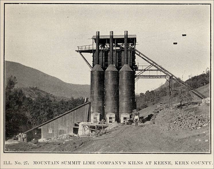
- Keene Station, Kern County, California - the Mountain Summit Lime
Company Quarry & Kilns (From The Structural and Industrial
Materials of California, Bulletin No. 38, California, State Mining
Bureau, San Francisco, California, 1906.)
"Mountain Summit Lime Company, 324 Requiena street, Los Angeles, owns a large lime quarry at Keene station, 8 miles northwest of Tehachapi. Large quantities of lime are burned and shipped to various points. The limestone and the resulting lime are said to be similar to that at Tehachapi."
Ill. No. 27. Mountain Summit Lime Company's Kilns at Keene, Kern County. 
- Keene (near), Kern County, California - Mountain
Summit Limestone Deposit (Limestone) (Excerpt from "Limestone
in California," by Clarence A. Logan, California Journal of
Mines and Geology, Vol. 43, No. 3, July 1947, California Division
of Mines, San Francisco, California, pp. 175-357. Used with permission,
California Department of Conservation, California Geological Survey.)
"Mountain Summit limestone deposit is near Keene, a railroad station west of Tehachapi. The Mountain Summit Lime Company burned lime from the deposit 30 to 40 years ago, but there has been no recent production."
- Keene (near), Kern County, California - Mountain
Summit Limestone Deposit (Limestone) (Excerpt from "Limestone
in California," by Clarence A. Logan, California Journal of
Mines and Geology, Vol. 43, No. 3, July 1947, California Division
of Mines, San Francisco, California, pp. 175-357. Used with permission,
California Department of Conservation, California Geological Survey.)
- Kern County, California - 109 Limestone Quarry /
Lebec (Limestone) (active ca 1996) (From Mines and Mineral Producers
Active in California (1994-1995), Special Publication 103 (Revised
1996), California Department of Conservation, Division of Mines and Geology,
in cooperation with California Department of Conservation, Office of Mine
Reclamation. Used with permission, California Department of Conservation,
California Geological Survey.)
Mine name: 109 Limestone Quarry/Lebec; Operator: National Cement Company; Address & County: P.O. Box 1247, Lebec, CA 93243, Kern County; Phone: (805) 248-6733; Latitude: 34.85, Longitude: -118.78, and Mine location number: Map No. 222; Mineral commodity: limestone.
- Kern County, California - Blake Wholesale Stone Co.
(Stone) (active ca 1996) (From Mines and Mineral Producers Active
in California (1994-1995), Special Publication 103 (Revised 1996),
California Department of Conservation, Division of Mines and Geology,
in cooperation with California Department of Conservation, Office of Mine
Reclamation. Used with permission, California Department of Conservation,
California Geological Survey.)
Mine name: Blake Wholesale Stone Co.; Operator: Blake's Wholesale Stone; Address & County: 201 A Panamint Ave., Ridgecrest, CA 93555, Kern County; Phone: (619) 375-4430; Latitude: 35.46, Longitude: -117.73, and Mine location number: Map No. 226; Mineral commodity: Stone.
- Kern County, California - Central Lime Co. (Lime) 303 Henne Building, Los Angeles (From The Structural and Industrial Materials of California, Bulletin No. 38, California, State Mining Bureau, San Francisco, California, 1906. No other information was given.)
- Kern County, California - Erskine Creek Limestone
Deposits (Limestone) (Excerpt from "Limestone in California,"
by Clarence A. Logan, California Journal of Mines and Geology,
Vol. 43, No. 3, July 1947, California Division of Mines, San Francisco,
California, pp. 175-357. Used with permission, California Department of
Conservation, California Geological Survey.)
"Erskine Creek limestone deposits extend along Erskine Creek in the eastern part of T. 27 S., R. 33 E., M.D., the southwestern part of T. 27 S., R. 34 E., and the western part of T. 28 S., R. 34 E., M.D. The deposits are from 30 to 36 miles by road from Caliente, the nearest railroad point, and at elevations ranging from 4000 to 7000 feet. The outcrops are not continuous, being interrupted by intrusive rocks. The strike is N. 40 W. and dip very steep. the limestone ranges in character from hard marble to sandy, more or less siliceous stone. No development of the limestone as such has been reported (Brown 16, p. 517."*
(* G. Chester Brown, "Kern County," California Mining Bureau Report 14, pp. 471-523, illus., 1916.)
- Kern County, California - Erskine Creek Quarry/Mine
(Limestone) (Excerpt from "Mineral Resources of Kern County,
California," by W. B. Tucker, R. J. Sampson, and G. B. Oakeshott,
California Journal of Mines and Geology, pp. Vol. 45, No. 2, April 1949,
pp. 203-297. Used with permission, California Department of Conservation,
California Geological Survey.)
From "Tabulated list of mines in Kern County - Nonmetals": Ref. No.: 325; Name of mine: Erskine Creek; Owner (name and address): (blank); Location: Sec. (?); T. 27 S., R. 33 E., M.D.M.D.; Mineral product: Limestone; Remarks and references: Idle. Report 25, p. 70.
- Kern County, California - Hy Desert Rustic Stone
(Stone) (active ca 1996) (From Mines and Mineral Producers Active
in California (1994-1995), Special Publication 103 (Revised 1996),
California Department of Conservation, Division of Mines and Geology,
in cooperation with California Department of Conservation, Office of Mine
Reclamation. Used with permission, California Department of Conservation,
California Geological Survey.)
Mine name: Hy Desert Rustic Stone; Operator: Standford Stone Company; Address & County: P.O. Box 1161, Atascadero, CA 93423, Kern County; Phone: (805) 466-0650; Latitude: 35.31, Longitude: -117.68, and Mine location number: Map No. 245; Mineral commodity: Stone.
- Kern County, California - Isabella Limestone Quarry/Mine
(Limestone) (Excerpt from "Mineral Resources of Kern County,
California," by W. B. Tucker, R. J. Sampson, and G. B. Oakeshott,
California Journal of Mines and Geology, pp. Vol. 45, No. 2, April 1949,
pp. 203-297. Used with permission, California Department of Conservation,
California Geological Survey.)
From "Tabulated list of mines in Kern County - Nonmetals": Ref. No.: 326; Name of mine: Isabella limestone; Owner (name and address): (blank); Location: Sec. (blank), T. 26 S, R. 33 E., M.D.M.D. & Sec. (blank), T. 27 S., R. 34 E.; Mineral product: Limestone; Remarks and references: Idle. Report 25, p. 70.
- Kern County, California - Kern Front Borrow Pit (Stone)
(active ca 1996) (From Mines and Mineral Producers Active in California
(1994-1995), Special Publication 103 (Revised 1996), California Department
of Conservation, Division of Mines and Geology, in cooperation with California
Department of Conservation, Office of Mine Reclamation. Used with permission,
California Department of Conservation, California Geological Survey.)
Mine name: Kern Front Borrow Pit; Operator: Chevron USA Production Company; Address & County: 3300 Monte Crisco Rd., Bakersfield, CA 93308, Kern County; Phone: (805) 392-3364; Latitude: 35.49, Longitude: -119.08, and Mine location number: Map No. 250; Mineral commodity: Stone.
- Kern County, California - Microwave Quarry / Lebec
Plant (Limestone) (active ca 1996) (From Mines and Mineral Producers
Active in California (1994-1995), Special Publication 103 (Revised
1996), California Department of Conservation, Division of Mines and Geology,
in cooperation with California Department of Conservation, Office of Mine
Reclamation. Used with permission, California Department of Conservation,
California Geological Survey.)
Mine name: Microwave Quarry / Lebec Plant; Operator: National Cement Company; Address & County: P.O. Box 1247, Lebec, CA 93243, Kern County; Phone: (805) 248-6733; Latitude: 34.85, Longitude: -118.77, and Mine location number: Map No. 253; Mineral commodity: Limestone.
- Kern County, California - Mojave Quarry (Limestone)
(active ca 1996) (From Mines and Mineral Producers Active in California
(1994-1995), Special Publication 103 (Revised 1996), California Department
of Conservation, Division of Mines and Geology, in cooperation with California
Department of Conservation, Office of Mine Reclamation. Used with permission,
California Department of Conservation, California Geological Survey.)
Mine name: Mojave Quarry; Operator: California Portland Cement Co.; Address & County: P.O. Box 910, Mojave, CA 93501, Kern County; Phone: (818) 852-6258; Latitude: 35.03, Longitude: -118.33, and Mine location number: Map No. 257; Mineral commodity: Limestone.
- Kern County, California - Sandstone Deposit on Government Land
(Sandstone) - Excerpt from the Tenth Annual Report of
The State Mineralogist For The Year Ending December 1, 1890, California
State Mining Bureau, Sacramento: State Printing Office, 1890, pp. 225.
“Kern County , by Myron Angel, Assistant in the Field.
“Also, a gray sandstone, which is easily quarried in blocks two to three feet in thickness and fifteen or twenty feet long, and which dresses well for building stone. This is upon Government land, and but a few miles from the surveyed route of a railroad that is expected soon to be constructed.”
- Kern County, California - Summit Limestone (Excerpt
from "Mineral Resources of Kern County, California," by W.
B. Tucker, R. J. Sampson, and G. B. Oakeshott, California Journal of Mines
and Geology, pp. Vol. 45, No. 2, April 1949, pp. 203-297. Used with permission,
California Department of Conservation, California Geological Survey.)
From "Tabulated list of mines in Kern County - Nonmetals": Ref. No.: 328; Name of mine: Summit limestone; Owner (name and address): Summit Lime Company, Whittier, Calif.; Location: Sec. (blank), T. 11 N., R. 15 W., S.B.M.D. (T. 12 N. is also listed below T. 11 N.); Mineral product: Limestone; Remarks and references: Idle. Report 25, p. 72.
- Kern County, California - Ulti-Solutions Inc.
Stone Quarry (From United States Geological Survey, Mineral Industries Surveys Directory of Principal Dimension Stone Producers in the United States in 1995, prepared in January 1997.)
In 1995 Ulti-Solutions Inc. was operating a stone quarry in Kern County. (The type of stone is not specified.) At that time the company headquarters was in Ridgecrest, California.
- Kern County, California - White Ridge Dolomite Mine/Quarry
(Dolomite) (Excerpt from "Mineral Resources of Kern County, California,"
by W. B. Tucker, R. J. Sampson, and G. B. Oakeshott, California Journal
of Mines and Geology, pp. Vol. 45, No. 2, April 1949, pp. 203-297.
Used with permission, California Department of Conservation, California
Geological Survey.)
From: "Tabulated list of mines in Kern County - Nonmetals": Ref. No.: 317; Name of mine: White Ridge dolomite; Owner (name and address): Florence Cuddy, Frazier Park, Calif.; Location: Sec. 25, T. 9 N., R. 20 W, S.B. M.D.; Mineral product: Dolomite; Remarks and references: Idle.
- Kern County, California - Union Lime (Limestone)
(Excerpt from "Mineral Resources of Kern County, California,"
by W. B. Tucker, R. J. Sampson, and G. B. Oakeshott, California Journal
of Mines and Geology, pp. Vol. 45, No. 2, April 1949, pp. 203-297.
Used with permission, California Department of Conservation, California
Geological Survey.)
From "Tabulated list of mines in Kern County - Nonmetals": Ref. No.: 329; Name of mine: Union lime; Owner (name and address): Union Lime Company; Location: 1720 acres, T. 12 N., R. 15 W., S.B.M.; Mineral product: Limestone; Remarks and references: Idle. Report 13, p. 628; Report 14, pp. 518-519.Tehachapi (east of), Kern County, California - Union Lime
(Also see Tehachapi (east of), Kern County, California - Summit Lime circa 1914.)
- Lebec (south of west of), Kern County, California
- Cuddy Canyon Limestone Deposits (Limestone) (Excerpt from "Limestone
in California," by Clarence A. Logan, California Journal of Mines
and Geology, Vol. 43, No. 3, July 1947, California Division of Mines,
San Francisco, California, pp. 175-357. Used with permission, California
Department of Conservation, California Geological Survey.)
"Cuddy Canyon deposits are in the southern part of T. 9 N., R. 20 W., M.D., 8 miles south of west from Lebec, on a ridge on the north side of Cuddy Canyon at an elevation of about 5300 feet. This is a prominent part of the highly crystalline limestone outcropping in granite, first mentioned by H. W. Fairbanks (94, p. 495)* as extending in numerous detached areas from the vicinity of Gorman westward. On the three claims held by Henry Kramer in 1929, the limestone is said to be exposed for 4500 feet with a width of about 300 feet. It is white, high-calcium stone. So far as known no work has been done on it. Castaic, about 45 miles south by state highway, is the nearest railroad point."
(* Harold Wellman Fairbanks, "Geology of Northern Ventura, Santa Barbara, San Luis Obispo, Monterey, and San Benito Counties," California Mining Bureau Report 12, pp. 493-526, 1894.)
- Kern County, California - Cuddy Canyon Limestone
(Excerpt from "Mineral Resources of Kern County, California,"
by W. B. Tucker, R. J. Sampson, and G. B. Oakeshott, California Journal
of Mines and Geology, pp. Vol. 45, No. 2, April 1949, pp. 203-297.
Used with permission, California Department of Conservation, California
Geological Survey.)
From "Tabulated list of mines in Kern County - Nonmetals": Ref. No.: 324; Name of mine: Cuddy Canyon limestone; Owner (name and address): Henry Kramer, La Crescenta, Calif.; Location: Sec. (?); T. 27 S, R. 33 E., S.B.M.D.; Mineral product: Limestone; Remarks and references: Idle. Report 25, p. 70.
- Kern County, California - Cuddy Canyon Limestone
(Excerpt from "Mineral Resources of Kern County, California,"
by W. B. Tucker, R. J. Sampson, and G. B. Oakeshott, California Journal
of Mines and Geology, pp. Vol. 45, No. 2, April 1949, pp. 203-297.
Used with permission, California Department of Conservation, California
Geological Survey.)
- Maricopa (nearest town), Kern County, California
- Mountain Minerals Dolomite Deposit (Dolomite) (Excerpt from "Limestone
in California," by Clarence A. Logan, California Journal of Mines
and Geology, Vol. 43, No. 3, July 1947, California Division of Mines,
San Francisco, California, pp. 175-357. Used with permission, California
Department of Conservation, California Geological Survey.)
"Mountain Minerals dolomite deposit is covered by four locations, 1200 feet by 3000 feet, made in September and October 1943 by Vetta V. Bartholemew, c/o McCarty Brothers, Taft, California. The claims are in Piru district 34 miles southeast of a railroad, at 6000 to 7000 feet elevation, in rugged country. The nearest town is Maricopa. There is some pine timber and three springs, and a surfaced highway passes within 1 ½ miles of claims. The owner claims to have a very large deposit with an MgO content of 21 percent."
- Monolith, Kern County, California – Monolith Portland
Cement Company (Limestone Quarry and Cement Plant)
- Monolith, Kern County, California – Monolith Portland Cement Company (Limestone Quarry) The following photograph is from “Quarry Blast Loosens 350,000 Tons,” in Engineering and Mining Journal-Press, June 12, 1926, pp. 974.
“Blast at Monolith Quarry, Monolith, Calif., May 9, 1926,” photograph in the article, “Quarry Blast Loosens 350,000 Tons,” Engineering and Mining Journal-Press, June 12, 1926 
- Monolith, Kern County, California - Monolith Portland
Cement Company (Limestone Quarry and Cement Plant) (Excerpt from "Limestone
in California," by Clarence A. Logan, California Journal of Mines
and Geology, Vol. 43, No. 3, July 1947, California Division of Mines,
San Francisco, California, pp. 175-357. Used with permission, California
Department of Conservation, California Geological Survey.)
"Monolith Portland Cement Company, 215 West Seventh Street, Los Angeles, in 1921 took over the operation of the cement plant that had been built and operated previously by the city of Los Angeles to furnish portland cement for use in the aqueduct from Owens River. The plant is on the railroad at Monolith a few miles east of Tehachapi summit. It is a wet-process plant with an annual capacity of 2,000,000 barrels. The plant was described in detail by Tucker (29).*
(* W. Burling Tucker, Los Angeles Field Division, "Kern County," California Division of Mines and Mining Report 25, illus., 1929.) "The limestone deposit originally worked and in part still available is on 160 acres owned by the company in sec. 14, T. 32 S., R. 33 E., M.D., 4 miles by road northwest of the plant. There a quarry face 1500 feet long and several hundred feet high was opened. Later 2500 acres of limestone lands were taken under a long-term lease, and this is being worked on royalty."
- Monolith, Kern County, California - Monolith
Portland Cement Company (Limestone Quarry and Cement Plant) (Excerpt
from "Mineral Resources of Kern County, California," by
W. B. Tucker, R. J. Sampson, and G. B. Oakeshott, California Journal
of Mines and Geology, pp. Vol. 45, No. 2, April 1949, pp. 203-297.
Used with permission, California Department of Conservation, California
Geological Survey.)
"Monolith Portland Cement Company, Coy Burnett, president, A. G. Bartlett Building, Los Angeles, operates the only cement plant in Kern County. It is located at Monolith, about 4 miles east of Tehachapi.
"The plant was originally built by the City of Los Angeles to manufacture cement used in the construction of the Owens Valley aqueduct.
"The limestone for the plant comes from a deposit in sec. 14, T. 32 S., R. 33 E., M. D., about 3 miles east of Monolith. The plant and deposit have already been described by Tucker.*
(* Page 245 footnote 14: Tucker, W. B., Kern County: California Div. Mines and Mining Rept. 25, pp. 70-72, 1929.)
From "Tabulated list of mines in Kern County - Nonmetals": Ref. No.: 327; Name of mine: Monolith Portland Cement Co.; Owner (name and address): Monolith Portland Cement Co., A. G. Bartlett Bldg., Los Angeles, Calif.; Location: Sec. 14, T. 32 S., R. 33 E., M.D.M.; Mineral product: Limestone, cement; Remarks and references: Report 25, pp. 70-72.
Monolith Portland Cement Company
Plate 11-A. Cement plant. Photo by C. A. Averill. 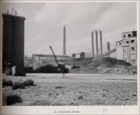
Plate 11-B. Quarry. Narrow-gage locomotive in center. Photo by C. A. Averill. 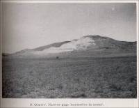
- Monolith, Kern County, California – Monolith Portland Cement Company (Limestone Quarry) The following photograph is from “Quarry Blast Loosens 350,000 Tons,” in Engineering and Mining Journal-Press, June 12, 1926, pp. 974.
- Monolith, Kern County, California - Monolith Portland
Cement Co. (Cement) (Excerpt from "California Mineral Commodities
in 1951," California State Division of Mines, California Journal
of Mines and Geology, pp. Vol. 50, No. 1, January 1954, pp. 59-147. Used
with permission, California Department of Conservation, California Geological
Survey.)
(Operator) Monolith Portland Cement Co.; (Address) Box 3947, Glassell Sta., Los Angeles 65; (Location) Monolith.
- Kern County, California - Monolith Limestone
Quarry (Limestone) (active ca 1996) (From Mines and Mineral
Producers Active in California (1994-1995), Special Publication 103
(Revised 1996), California Department of Conservation, Division of
Mines and Geology, in cooperation with California Department of Conservation,
Office of Mine Reclamation. Used with permission, California Department
of Conservation, California Geological Survey.)
Mine name: Monolith Limestone Quarry; Operator: Calaveras Cement Company; Address & County: 13573 Tehachapi Blvd., Monolith, CA 93548, Kern County; Phone: (805) 822-4445; Latitude: 35.14, Longitude: -118.38, and Mine location number: Map No. 258; Mineral commodity: Limestone.
- Kern County, California - Monolith Limestone
Quarry (Limestone) (active ca 1996) (From Mines and Mineral
Producers Active in California (1994-1995), Special Publication 103
(Revised 1996), California Department of Conservation, Division of
Mines and Geology, in cooperation with California Department of Conservation,
Office of Mine Reclamation. Used with permission, California Department
of Conservation, California Geological Survey.)


Commercial use of material within this site is strictly prohibited. It is not to be captured, reworked, and placed inside another web site ©. All rights reserved. Peggy B. and George (Pat) Perazzo.