
Latrobe Through Shingle Springs (Continued)
- Placerville,
El Dorado County, California – Placerite Building Stone
Quarry, Kiln, & Placerite/Alexyte Products, located
at 5414 Newtown Road, Placerville, CA 95667; (530) 644-5596 (present-day
company) (Located southeast of Placerville at
the intersection of Pleasant Valley and Newtown Road)
For the last 20 years the Sierra Placerite (rhyolite tuff) has been mined by this company. The product is made by firing the tuff to extreme temperatures resulting in a hard, deeply colored magenta to purple. The company calls the new mineral “Alexyte,” which was named after Alexandria Todd in 1991. The fired products produced today are fired at a much higher temperature than the 1950s operation.* The Alexyte products are fired 500 to 700 degrees hotter than previous producing a much harder and deeply colored product being purple in color as compared to the orange color of years ago.
(* From the 1950 entry above: “The lighter colors are obtained by firing at about 1600 ° F.; a brick-red color is obtained by firing at 2000 ° F.”)
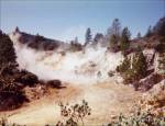
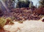
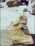
The following photographs of the present-day quarry, stone, and products and were contributed by Ted Fiedler, who operates the company.
Overview of Sierra Placerite (Rhyolite Tuff) Quarry. 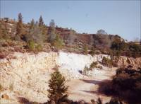
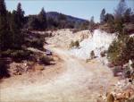
Looking west in Quarry. Boom! Rhyolite Block. 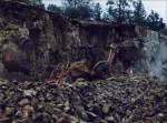
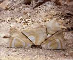
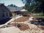
Mining Rhyolite. Split Rhyolite. Placerite Walkway. 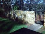
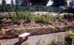
Placerite Walls. “The one, the only ‘Alexyte’ clock named after 4-year-old Alexandria Todd in 1991 who helped with the firing process.” 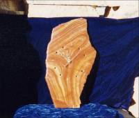
“Alexyte” anniversary clock with gold nugget numerals. “Alexyte,” a thermally altered form of rhyolite developed in 1991 by Ted Fiedler and Alexandria Todd, Placerville, CA. 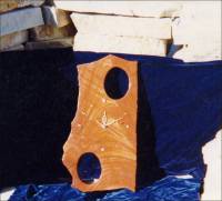
Falcon on Placerite by professional carver Georg Schmerholz 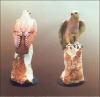
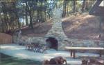
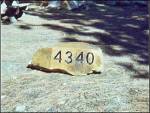
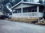
Rhyolite chimney Engraved address
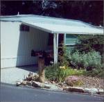
markerMailboxes mounted
on Rhyolite columns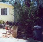

More mailboxes
mounted on Rhyolite
columnsLights mounted on
columns, birdbaths,
sundials and bookends
(on shelf) all made
with RhyoliteFountain carved
of Rhyolite -
Placerville (south of), El Dorado County, California – Sierra Rock – Diamond Quarry, 1845 Quarry Road (Aggregate Stone) (present-day quarry)
In 2002, the quarry located at 1845 Quarry Road, Placerville, California, was also referred to as the “Diamond Quarry” in the (PDF) document, “Order of the State Mining and Geology Board Imposing Administrative Penal Ties in the matter of: Diamond Quarry, California Mine ID Number 91-09-0003, Sierra Rock, Operator, Loring Brunius, Owner, Freda D. Pechner, Agent, 1845 Quarry Road, Placerville, California 95667.”
-
Placerville (south of), El Dorado County, California – Sierra Rock – Weber Creek Quarry, 1845 Quarry Road (Aggregate Stone) (present-day quarry)
According to the Sun Angle Test Visible Emission Evaluation, Sierra Rock, Weber Creek Quarry, Placerville, California (PDF), prepared for the Air Resources Board by Steve McKinney, of the Air Quality Management District in El Dorado County dated December 21, 2005:
“The Sierra Rock, Weber Creek Quarry can approximately be described as shelves cut in an easterly and southeasterly direction into a large hill. The quarry is currently benching and pushing material to the northwest onto the quarry floor. Approximately in the center of the property lies the aggregate processing facilities; Main Plant and Simplicity Nuzi Plant….”
An aerial photograph of the Weber Creek Quarry is presented in Appendix D of this report.
- Pleasant Valley, El Dorado County, California – the Sierra Placerite Quarry (Rhyolite Tuff) (From “Mines of El Dorado County,” by Doug Noble, El Dorado County Library web site. You can view this document in PDF format on the El Dorado County Library web site, or you can download the PDF document to your computer. See the “El Dorado County History” section for instructions to download the document. The following quote is used with permission of the El Dorado County Library.)


(Placerite Stone Co. - Also see: Newtown (south of), El Dorado County, California – Sierra Placerite Quarry and Kilns above.)
Also see: “Placerville, El Dorado County, California – Sierra Rock – Weber Creek Quarry, 1845 Quarry Road (Aggregate Stone)” below.
According to the California Dept. of Transportation data (PDF) the Sierra Rock Diamond Quarry was also located at 1845 Quarry Road, Placerville, California. (The link from which this information was obtained is no longer available.)
<http://www.dot.ca.gov/hq/tsip/gis/ca_aggregate_map/metadata/Mine_table.pdf>
- Rattlesnake Bar (southeast of), El Dorado County, California – Auburn Lime Products Company (Limestone) (Excerpt from "Limestone in California," by Clarence A. Logan, California Journal of Mines and Geology, Vol. 43, No. 3, July 1947, California Division of Mines, San Francisco, California, pp. 175-357. Used with permission, California Department of Conservation, California Geological Survey.)
"Auburn Lime Products Company. Fred Weybret of Salinas is president. Main office is at 486 California Street, San Francisco. John J. Taylor is secretary and general manager.
"This is a new company formed to work a limestone deposit about a mile southeast of Rattlesnake Bar, which has previously been operated at intervals since the sixties by the Holmes Lime Company, Farmer Lime Company, Newcastle Lime Company, and between 1930 and 1942 by Auburn Chemical Lime Company. The present company has installed a rotary kiln and crushing equipment and plans to be in operation soon (May 1946). Newcastle, 7 miles northwest, is the rail shipping point.
"The deposit is a lens of high-calcium limestone standing nearly on edge in amphibolite schist, striking nearly north, and dipping steeply east. It is bluish gray to white, of medium to fine subhedral crystals. There are a few narrow streaks of schist in the limestone. The age of such deposits in the Sierra Nevada foothills has generally been considered Calaveras (Carboniferous, Mississippian) but the classification is based on meager fossil evidence found in only a few of the limestone beds, and most of the lens-shaped deposits, such as this one, have undergone enough metamorphism to destroy possible fossil forms. Some of the deposits may be Permian.
"In earlier days lime was burned on the north part of the deposit near Alabaster Cave, where natural caves in the limestone formed an attraction for sight-seers until many beautiful stalactites and stalagmites had been destroyed. The latter work has been on the south. There two open cuts were run, one 300 feet long from the south and another 475 feet from the north. They have a maximum depth of 75 feet and a width of 25 to 50 feet so that a total of about 100,000 tons was removed. This part of the deposit stood above the kiln level, so the stone could be hand trammed to the top of the kilns. A large part of the lime was hydrated and sold for use in cyanide plants treating gold ores, to farmers for use in fruit-tree sprays and as a soil corrective. Some limestone was also ground and sold for glass making, as well as for agricultural purposes. A CaCO3 content of 97 percent was claimed and analysis by the State Department of Agriculture showed 97.53 percent CaCO3.
"After the above was written, this company completed the installation of the plant, and operated until October 1946. During the above short period of activity, limestone was taken from the south quarry. Down holes were drilled with jackhammers, and after blasting, large blocks were broken by hand with sledges to one-man size. Stone was loaded into trucks by diesel tractor shovel and hauled to the plant. Part of the limestone was crushed and screened in a small plant containing a jaw crusher, hammer mill, 'Ripl-Flow' and 'Hum-mer' screens, which produced turkey grit, chicken grit, and limestone flour. Most of the stone went to a size 50 'Kue-Ken' crusher which broke it to kiln size.
"Early in 1947 the owning company resumed operation of the lime kiln. Since then all limestone has been purchased from California Rock and Gravel Company near Cool, and hauled 10 miles by truck. This limestone is the minus 2-inch material left after preparation of coarser sizes. It is dense, fine-grained, hard gray stone carrying 98 to 99 percent CaCO3, and making excellent lime, most of which is shipped to steel plants. George L. Kelly, Auburn, is manager, and Ray Webber is plant superintendent.
"The new rotary kiln is 4 by 60 feet and is equipped with a pre-heater in which limestone is heated to a temperature of about 1000 degrees Fahrenheit by waste heat from kiln. The stone is fed to pre-heater by bucket elevator and discharged from it to kiln by a plunger operated by eccentric with 1-inch throw. The kiln has a capacity of 27 tons of lime daily. It is fired with 15-degree gravity crude oil, heated to 160 to 180 degrees and supplied under 60-pound pressure. Burnt lime is discharged to a cooler section about 30 feet long. From there it is taken by bucket elevator to a two-deck vibrating screen which is housed on top of the storage silo. This silo is a new type supplied locally by Mark Lintz, San Francisco. It is 18 feet in diameter by 36 feet high, divided into four compartments by bulkheads and has space at the base for sacking machinery and scales. The capacity is 200 tons of lime. It is built of concrete staves containing 3/8-inch reinforcing bars. The staves are keyed together laterally with wooden splines 1 ¼ inches square in cross section and bound with steel hoops, under which wooden battens cover the joints.
"Besides the old quarries from which most of the limestone has been taken in the past, the company has acquired rights on the north, giving it a length of about 3000 feet along the strike including the Coles property.
"The following analysis of limestone is of a sample taken by the writer over a width of 25 feet in the south pit; it was made by Abbot A. Hanks, Inc.
Insoluble, 0.32 percent
Ferric and aluminic oxides, 0.27 percent
Calcium carbonate, 98.94 percent
Magnesium carbonate, 0.38 percent
Total, 99.91 percent"The following analysis of quicklime made in the new plant was furnished by the company:
SiO2, 0.10 percent
A12O3, 0.91 percent
Fe2O3, 0.07 percent
CaO, 94,64 percent
MgO, 0.49 percent
S, 0.004 percent
P2O5, 0.167 percent
CO2, 0.42 percent
Volatile, 3.19
Total, 99.991 percent23-A. Loading Limestone - California Rock and Gravel Company's Cave Valley limestone deposit near Cool, El Dorado County. 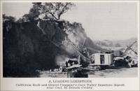
- Ringgold, El Dorado County, California - Marble Discovered near Ringgold, 1851 (Marble) (The following newspaper article was transcribed by Betty Loose, February 2, 2004, on the Norcal email list.)
Sacramento Transcript, Tuesday January 28, 1851
“CALIFORNIA MARBLE - An extensive vein of splendid marble, viewing with the Italian in point of quality, is reported as having been discovered in the neighborhood of Ringgold, El Dorado county.”
- Shingle Springs (southwest of), El Dorado County, California - the Bernett Property (Soapstone) (From "Mines and Mineral Resources of El Dorado County, California," California Journal of Mines and Geology, Vol. 52, No. 4, October 1956, California Division of Mines. Used with permission, California Department of Conservation, California Geological Survey.)
"Bernett Property. Location: sec. 23, T. 9 N., R. 9 E., M. D., 4 miles southwest of Shingle Springs adjacent to the Southern Pacific Railroad. Ownership: D. P. Bernett, Shingle Springs, California; leased by Frank Harris, 580 North L Street, Livermore, California.
"Soapstone has been mined intermittently at this property by Mr. Harris since 1953. It is mined by stripping with a bulldozer. The soapstone is trucked in crude form to the Industrial Minerals Chemical Company in Berkeley, where it is ground for use as an insecticide carrier.
"The deposit is a north-trending body of talc schist at least 500 feet in length. Width of the body ranges from 40 to 60 feet, and it has been bulldozed to a depth of 10 feet. The schist is fine grained, and its color ranges from light gray to reddish brown, the latter caused by iron oxide staining. The presence of iron oxide does not lower its value as an insecticide carrier. (Frank Harris, personal communication, 1954). The pit is approximately 100 feet long and ranges from 40 to 60 feet in width."
- Shingle Springs (four miles southwest of), El Dorado County, California - the Bernett Property (Soapstone) (From "Mines of El Dorado County," by Doug Noble, El Dorado County Library web site. You can view this document in PDF format on the El Dorado County Library web site, or you can download the PDF document to your computer. See the “El Dorado County History” section for instructions to download the document.)
- Shingle Springs (21southwest of), El Dorado County, California – El Dorado Limestone Company (Limestone) (Excerpts from "Limestone in California," by Clarence A. Logan, California Journal of Mines and Geology, Vol. 43, No. 3, July 1947, California Division of Mines, San Francisco, California, pp. 175-357. Used with permission, California Department of Conservation, California Geological Survey.)
“The Sierra Placerite Quarry is one of the few dimension stone mines in El Dorado County. It is located just north of the junction of Newtown and Pleasant Valley roads in Pleasant Valley. The deposit, large beds of vitric crystal rhyolite tuff of Miocene age, some several hundred feet thick, occur in the region. The fine grained material is mined from open pits and then sawed and broken into the desired size for walls, building fronts, fireplaces, decorative items and the like. Naturally a light buff to white in color, it is often 'cooked' to drive off moisture, which changes the color to shades of orange, red or pink.”

This soapstone mine was operated 1953.
- Shingle Springs, El Dorado County, California – El Dorado Limestone Co. (Lime) (Excerpts from "California Mineral Commodities in 1951," California State Division of Mines, California Journal of Mines and Geology, pp. Vol. 50, No. 1, January 1954, pp. 59-147. Used with permission, California Department of Conservation, California Geological Survey.)
(Operator) El Dorado Limestone Co., J. H. Bell, President (industrial lime); (Address) Shingle Springs; (Location) Shingle Springs.
- Shingle Springs (three miles southwest of), El Dorado County, California - the El Dorado Limestone Mine (From "Mines of El Dorado County," by Doug Noble, El Dorado County Library web site. You can view this document in PDF format on the El Dorado County Library web site, or you can download the PDF document to your computer. See the “El Dorado County History” section for instructions to download the document.)
This limestone mine was an underground operation which produced a high-calcium limestone. "...Prior to the opening of the mine by the El Dorado Lime and Minerals company in 1918, limestone was quarried just north of the mine and burned in nearby stone lime kilns for building purposes. In 1931, the El Dorado Limestone Company was formed and operated the mine until it closed. The deposit consists of two lenses of limestone, one averaging sixty feet in width, the other forty feet. The main working entry is a 1000 foot, three compartment vertical shaft near the east wall of the east lens."
- Shingle Springs (four miles from), El Dorado County, California - the Harold Mine (Soapstone) (From "Mines of El Dorado County," by Doug Noble, El Dorado County Library web site. You can view this document in PDF format on the El Dorado County Library web site, or you can download the PDF document to your computer. See the “El Dorado County History” section for instructions to download the document.)
"The Harold Mine was an undeveloped prospect for soapstone (used in wood stoves and sculpting), four miles from Shingle Springs."
- Shingle Springs (southwest of), El Dorado County, California - the Hayden Property (Soapstone) (From "Mines and Mineral Resources of El Dorado County, California," California Journal of Mines and Geology, Vol. 52, No. 4, October 1956, California Division of Mines. Used with permission, California Department of Conservation, California Geological Survey.)
"Hayden Property. Location: sec. 7, T. 9 N., R. 10 E., M. D., 1 ¾ miles southwest of Shingle Springs; leased to Industrial Minerals and Chemicals Company of Berkeley.
"The deposit is a lensoid body of iron oxide-stained greenish soapstone which is on the west side of a small body of metasedimentary rock enclosed in greenstone. The soapstone is quarried from an open cut which is about 100 feet long, 40 feet wide, with a 20-foot face at the north end. A jackhammer is used in drilling. the excavated material is loaded into trucks with a Caterpillar loader. Frank Harris of Livermore has the contract to mine and haul the ore to plant."
- Shingle Springs (1 ¾ miles south of), El Dorado County, California - the Hayden Mine (Soapstone) (From "Mines of El Dorado County," by Doug Noble, El Dorado County Library web site. You can view this document in PDF format on the El Dorado County Library web site, or you can download the PDF document to your computer. See the “El Dorado County History” section for instructions to download the document.)
This soapstone mine was operated by the Industrial Minerals and Chemical Company for many years on and off. "The soapstone was quarried from an open cut about 100 feet long and 40 feet wide, with a 20-foot face at the north end (1956 figures)."
- Shingle Springs (one mile east of), El Dorado County, California - the Shingle Springs (Rossi) Mines (Soapstone) (From "Mines of El Dorado County," by Doug Noble, El Dorado County Library web site. You can view this document in PDF format on the El Dorado County Library web site, or you can download the PDF document to your computer. See the “El Dorado County History” section for instructions to download the document.)
"One mile east of Shingle Springs was a soapstone mine known as the Shingle Springs (Rossi) Mine. Lenses of green soapstone in serpentine was developed by an open pit. The mined material was shipped for use as a roofing coating."
"El Dorado Limestone Company, J. H. Bell, president, has 465 acres 4 ½ miles by road southwest of Shingle Springs where limestone mining has been going on for 31 years. In earlier days, stone from the deposit was used to make lime for building purposes. El Dorado Lime and Minerals Company was the immediate predecessor of the present company, and their operations have been described by the author in a previous publication (Logan, C. A. 27, pp. 441-442).* The present company was formed in 1931. J. H. Bell, general manager, has been in charge of operations for many years for this and the preceding companies. The company has a right-of-way with 1.9 miles of standard-gauge spur track connecting with the Placerville branch of the Southern Pacific Railroad.
(*Clarence A. Logan, Sacramento Field Division, "El Dorado County," California mining Bureau Report 22, pp. 397-452, illus., 1927.)
"The deposit occurs in a series of lenses of white, high-quality limestone dipping 85 E. in a belt of Calaveras (Carboniferous) rocks from a quarter to half a mile wide. The lenses are separated by strips of the country rock and in places small dikes cut across the limestone. For many years two lenses have been mined by shrinkage stoping and by using benches or slicing and underhand stoping. Drifts 20 feet wide by 8 ½ feet high have been run. Widths worked have ranged generally from 20 to 70 feet. The object has been to make as much lump rock as possible. Coarse rock is drilled and blasted in the stopes and is broken again by hand with sledges on the grizzlys over the loading pockets at the shaft. For blasting, 25 percent dynamite is used.
"The mine is worked through a three-compartment vertical shaft 700 feet deep and the deposit has been proved for 1800 feet on the strike. The shaft is concrete-lined to the first level at 150 feet. Since the last report (Logan, C. A., 27)* a new steel headframe 100 feet high and a 160-ton ore bin have been erected, and a new 3-ton double-drum hoist has been installed.
(*Clarence A. Logan, Sacramento Field Division, "El Dorado County," California mining Bureau Report 22, pp. 397-452, illus., 1927.)
"From the headframe, rock passes almost entirely by gravity through a Ku-Ken crusher, over vibrating screens and through trommels to separate the different sized products. During the process, coarse rock is washed and hand sorted on conveyor belts to remove pieces showing adhering schist or dike rock. The final product is a clean, white to translucent high-calcium limestone of such uniform quality that Mr. Bell states they 'practically guarantee 98 percent CaCO3'. During the war, most of the output was shipped in railroad cars to the plant of Diamond Springs Lime Company where it was burned in two rotary kilns and shipped to steel mills. Other important uses are for paint, sugar- and glass-making. Sixty-seven carloads shipped to one user are stated to have averaged 97.65 percent CaCO3 and 0.24 percent SiO2.
The following analyses were furnished by J. H. Bell, who stated they were made by Abbot A. Hanks, Inc., San Francisco:
SiO2, 0.60 percent; 0.60 percent; 0.72 percent
R2O3 (A1,Fe oxides), 0.38 percent; 0.26 percent; 0.24 percent
CaCO3, 98.4 percent; 97.93 percent; 98.38 percent
MgCO3, 0.62 percent; 1.19 percent; 0.65 percent"This deposit did not outcrop conspicuously and was not mapped on the geologic folio for that district. It is an example of several in the region that were eroded nearly or quite to the old peneplain level and have been partly covered by soil, so that the outcrops of limestone now visible do not give an accurate idea of the possible extent of the deposits."
Commercial use of material within this site is strictly prohibited. It is not to be captured, reworked, and placed inside another web site ©. All rights reserved. Peggy B. and George (Pat) Perazzo.