

Arkansas
Geology Resources - Arkansas
- Arkansas Geological
Commission
- Arkansas Geology
- Geology Division
- Mineral Producers of Arkansas
- Minerals of Arkansas: An Electronic Database, by John David McFarland and J. Michael Howard, Arkansas Geological Commission Software Series No. 1, Windows Version 2, 2003.
- Non-metallic Resources
- Novaculite (Whetstones)
- Resource Reports
-
Arkansas State Minerals Information (U.S. Geological Survey)
- Arkansas State Information Page, U. S. Geological Survey
-
Arkansas GeoStor - An "online data delivery system that allows the user seamless access to digital map data (GeoData) of any area in Arkansas with no subscription fee."
-
Arkansas Novaculite: More Than a Whetstone, Lesson Plan by Julie Hill, Conway, Arkansas, 2001-2002 Butler Fellow.
-
Geologic Map of Arkansas, presented by Andrew Alden on About.com Geology. (Links are available for the Bedrock Geologic Maps of Arkansas for the Northwest Quadrant, Northeast Quadrant, Southwest Quadrant, Northeast Quadrant, and others.)
- Historical Geology / Petrology Combined Field Trip #1, Paleozoic Rocks of The Ozark Region, Arkansas Tech University, Russellville, Arkansas.
- Lafayette Geological Society
- Virtual Field Trips
in Arkansas (The links to the three field trips described below are no longer available on this web site. I’ve left the titles of the field trips in case you’d like to contact the Lafayette Geological Society about them. Peggy B. Perazzo)
- (Quarries described in the these fields trip accounts below are: Old Quarry, Malvern; Mid State (Old Highway 51) Quarry; and Diamond Jo Quarry.)
- Deep Water Turbidites in the Ouachita Mountains, Arkansas (Virtual Field Trip #4) Quarries described are: Hollywood Quarry, Part I & II; Souther Quarry; Baumgardner Quarry, Kirby Mountain; Big Rock Quarry, Part I, II, & III.
- Economic Geology and Mineralogy of Central Arkansas (Arkansas Virtual Field Trip #3) The mine described are: Old Coleman Crystal Mine, Part I.
- Structure, Stratigraphy, and Sedimentology of Paleozoic Rocks, Southeastern Ouachita Mountains, Arkansas (Arkansas Virtual Field Trip #2)
- National Geologic Map Database, presented by the United States Geologic Survey.
- Ouachita Mountains, GO 568, Structural Geology, James S. Aber, Emporia State University. "The Ouachitas are surficial mountains in parts of Arkansas and Oklahoma, and Ouachita structures are exposed in the Marathon Basin of West Texas."
- Rockhounding Arkansas
- University of Arkansas at Little Rock Department of Earth Sciences
- University of Arkansas – Department of Geosciences
Research Resources - Arkansas
- Archives
- The Arkansas History Commission and State Archives
- Arkansas USGenWeb Archives
- Repositories of Primary Sources – Arkansas
- Southwest Arkansas Regional Archives, Washington, Arkansas. (Covering the following Arkansas counties: Columbia County, Hempstead County, Howard County, Lafayette County, Little River County, Miller County, Nevada County, Ouachita County, Pike County, Polk County, Sevier County, and Union County.)
- University of Central Arkansas - Archives
- U. S. National Archives & Records Management (NARA)
- Historical Sources
- 1875 Peel Mansion and Historic Gardens, Bentonville, Arkansas.
- The American Local History Network - Arkansas
- Arkansas Buildings, Structures, & Architects on the Philadelphia Architects & Buildings Project (PAB) web site. You can search the database for buildings, structures, and architects either as a visitor or you can register free. You cannot search for specific cities, but you can search for county locations. There are no photographs presented, but the location and/or address and the name of the architect are included if known; and the historic registration information is also included.
- Arkansas Department of Parks and Tourism
- Arkansas GenWeb Project,
Betsy Mills, ARGenWeb Project State Coordinator, and Jeff Kemp, ARGenWeb
Project Assistant State Coordinator.
- Arkansas GenWeb Project Archives, Gina Heffernan, ARGenWeb Archives Project Coordinator.
- Arkansas Historical Association - Arkansas Historical Quarterly
-
Arkansas Historical Commission. (Subjects include: Northeast Arkansas Regional Archives; Southwest Arkansas Regional Archies; Arkansas Records Catalog; Catalog of Arkansas Resources and Archival Treasures, Arkansas Civil War; Black History; Folklife in Arkansas; & Arkansas County Records.)
-
Arkansas Novaculite: A Virtual Comparative Collection, Arkansas Archeological Survey, a division of the University of Arkansas System. (Sections include: “Novaculite as Whetstone Rock,” “History of the Whetstone Industry in the Hot Springs Area,” “Current Commercial Uses for Novaculite,” “Preserving History,” and a list of references about the history of whetstone mining in Arkansas.)
- Arkansas River Historical Society
-
Arkansas Sharpening Stones, by Rebecca Bowser, Physical Geology, Fall 2011 (novaculite)
- Arkansas State Land Commission
- Arkansas State Parks
- Benton County, Arkansas, Historical Society. Near the town of Beaver, in Benton County, limestone was quarried which provided building material locally and for other town such as Eureka Springs, Arkansas.
- Carroll County, Arkansas, Historical Society
- Department of Arkansas Heritage
- Delta Cultural Center, Helena, Arkansas. "The rich culture of the Mississippi Delta is found in sites, sounds, people and events in eastern Arkansas."
-
Dimension Stone Mining (in Arkansas), by J. Michael Howard, Mabelvale, Arkansas (including sections on “Rough Stone,” “Dressed or Cut Stone,” & “Historical and Present Production.” Presented on the Encyclopedia of Arkansas History & Culture web site.
- Encyclopedia of Arkansas: History and Culture “The Encyclopedia of Arkansas is a free, authoritative source of information about the rich history, geography, and culture of Arkansas.”
- Eureka Springs, Carroll County, Arkansas, History, presented by the Eureka Springs Tourist Center.
- Historic Arkansas, presented by UShistory.com.
- Historical Construction Equipment Association
- History & Heritage, presented by the Arkansas Department of Parks and Tourism.
- History of Southwest Arkansas, Sponsored by the History Department of Southern Arkansas University at Magnolia.
- The Kansas City Southern Railroad Lines - "A Brief History of The Kansas City Southern Railway Company, Louisiana & Arkansas Railway Company, Ft. Smith and Van Buren Railway Company, MidSouth Corporation, and Graysonia, Nashville & Ashdown Railroad Company," The 1,711 mile-long Kansas City Southern Railway Company line was constructed to connect the region and provide transportation of the area's resources in the states through which the line ran: Missouri, Kansas, Arkansas, Oklahoma, Louisiana, and Texas. It was built after the major settlement of the Midwest. (This web site is presented by the Kansas City Southern Historical Society.)
-
Mining (in Arkansas), by J. Michael Howard, Mabelvale, Arkansas (including “Recent Significant Mining Activity” and “Economic Impact.”)
- Libraries
- Museums
- Arkansas Museum Index compiled by the Arkansas Traveler
- Arkansas
Museum of Natural Resources, 3853 Smackover Highway,
Smackover, AR 71762;
(870) 725-2877. (Arkansas oil and brine industries)
- Arkansas River Historical Society Museum
- Historic Arkansas Museum
- Old State House Museum, Little Rock, Arkansas.
- Rogers Historical Museum, Rogers, Arkansas.
- Shiloh Museum of Ozark History
- Other
- 1895 U.S. Atlas - Arkansas
- Arkansas - the Natural State, presented by the Arkansas Department of Parks and Tourism.
- Arkansas Department of Parks and Tourism
- Arkansas Scenic Byways, presented by the National Scenic Byways Program.
- Bob's Rock Shop (Includes many related links.)
- Cyndi's List - Online Research Resources - Arkansas
- Facts About Arkansas (Geology and Geography, Minerals and Fossil Fuels)
- Rockinghounding Arkansas
- TopoZone "The TopoZone is the Web's center for recreational and professional topographic map users." (Includes a place name search form.)
- US Board on US Geographic Names - The New U.S. and Territories Query Form (Search the USGS Geographic Names Database)
- Yale
Peabody Museum: GNIS (Search the USGS Geographic Names Database)
The Arkansas Stone Industry
- 1856 - The following excerpt is from the 1856, The Marble-Workers' Handbook : "Arkansas is well supplied (with marble/limestone)."
- 1882 - The Arkansas Stone and Building Industry in 1882 (transcription), Excerpts from Mineral Resources of the United States, Calendar Year 1882, J. S. Powell, Director, Department of the Interior, United States Geological Survey, Government Printing Office, Washington, D. C., 1883. Excerpts from the chapters on 1) "Structural Materials" and 2) "The Useful Minerals of the United States."
- 1883 and 1884 Arkansas Stone and Building Industry (transcription), Excerpts from Mineral Resources of the United States - Calendar Years 1883 and 1884 (PDF images of sections), Department of the Interior, United States Geological Survey, Government Printing Office, Washington, D. C., 1885.
- 1885 - The Arkansas Stone and Building Industry in 1885 (transcription), Excerpts from Mineral Resources of the United States, Calendar Year 1885 (PDF images of sections), David T. Day, Geologist, Department of the Interior, United States Geological Survey, Government Printing Office, Washington, D. C., 1887. Excerpts from the chapters on 1) "Structural Materials," by H. S. Sproull; and 2) "Abrasive Materials."
- 1886 - The Arkansas Stone and Building Industry, 1886 (transcription), Excerpts from Mineral Resources of the United States, Calendar Year 1886 (PDF images of sections), David T. Day, Chief of Division of Mining Statistics and Technology, Department of the Interior, United States Geological Survey, Government Printing Office, Washington, D. C., 1887. Excerpts from the book are from the chapters on 1) "Structural Materials," by William C. Day; and 2) "Novaculite," by George M. Turner.
- 1887 - The Arkansas Stone and Building Industry, 1887, Excerpts from Mineral Resources of the United States - Calendar Year 1887 (PDF images of sections), J. W. Powell, Director, David T. Day, Chief of Division of Mining Statistics and Technology, Department of the Interior, United States Geological Survey, Government Printing Office, Washington, D. C., 1888
- 1888 - The Arkansas Stone and Building Industry, 1888, Excerpts from Mineral Resources of the United States - Calendar Year 1888 (PDF images of sections), J. W. Powell, Director, David T. Day, Chief of Division of Mining Statistics and Technology, Department of the Interior, United States Geological Survey, Government Printing Office, Washington, D. C., 1890
- 1889 and 1890 - The Arkansas Stone and Building Industry, 1889, Excerpts from Mineral Resources of the United States - Calendar Year 1889 and 1890 (PDF images of sections), J. W. Powell, Director, David T. Day, Chief of Division of Mining Statistics and Technology, Department of the Interior, United States Geological Survey, Government Printing Office, Washington, D. C., 1892
- 1891 - The Arkansas Stone and Building Industry, 1891, Excerpts from Mineral Resources of the United States - Calendar Year 1891 (PDF images of sections), J. W. Powell, Director David T. Day, Chief of Division of Mining Statistics and Technology, Department of the Interior, United States Geological Survey, Government Printing Office, Washington, D. C., 1893
- 1892 - The Arkansas Stone and Building Industry, 1892, Excerpts from Mineral Resources of the United States - Calendar Year 1892 (PDF images of sections), J. W. Powell, Director, David T. Day, Chief of Division of Mining Statistics and Technology, Department of the Interior, United States Geological Survey Government Printing Office, Washington, D. C., 1893
- 1893 - The Arkansas Stone and Building Industry, 1893, Excerpts from Mineral Resources of the United States - Calendar Year 1893 (PDF images of sections), J. W. Powell, Director, David T. Day, Chief of Division of Mining Statistics and Technology, Department of the Interior, United States Geological Survey, Government Printing Office, Washington, D. C., 1894
- 1894 - The Arkansas Stone and Building Industry, 1894, Excerpts from Sixteenth Annual Report of the United States Geological Survey (PDF images of sections), Part IV. Mineral Resources of the United States, 1894, Nonmetallic Products, Washington: Government Printing Office, 1894.
- 1895 - The Arkansas Stone and Building Industry, 1895, Excerpts from Seventeenth Annual Report of the United States Geological Survey (PDF images of sections), Part III. Mineral Resources of the United States, 1895, Nonmetallic Products, Except Coal. Washington: Government Printing Office, 1896.
- 1896 - The Arkansas Stone and Building Industry, 1896, Excerpts from Eighteenth Annual Report of the United States Geological Survey (PDF images of sections), Part V. Mineral Resources of the United States, 1896, Nonmetallic Products, Except Coal. Washington: Government Printing Office, 1897.
- 1897 - The Arkansas Stone and Building Industry, 1897, Excerpts from Nineteenth Annual Report of the United States Geological Survey (PDF images of sections), Part V. Mineral Resources of the United States, 1896, Nonmetallic Products, Except Coal. Washington: Government Printing Office, 1898.
- 1898 - The Arkansas Stone and Building Industry, 1898, Excerpts from Twentieth Annual Report of the United States Geological Survey (PDF images of sections), Part VI. Mineral Resources of the United States, 1898, Nonmetallic Products, Except Coal and Coke. Washington: Government Printing Office, 1899.
- 1899 - The Arkansas Stone and Building Industry, 1899, Excerpts from Twenty-first Annual Report of the United States Geological Survey (PDF images of sections), Part VI. Mineral Resources of the United States, 1899, Nonmetallic Products, Except Coal and Coke. Washington: Government Printing Office, 1901.
- 1900 - The Arkansas Stone and Building Industry, 1900, Excerpts from Mineral Resources of the United States - Calendar Year 1900 (PDF images of sections), Charles D. Walcott, Director, David T. Day, Chief of Division of Mining and Mineral Resources, Department of the Interior, United States Geological Survey, Government Printing Office, Washington, D. C., 1901
- 1901 - The Arkansas Stone and Building Industry, 1901, Excerpts from Mineral Resources of the United States - Calendar Year 1901 (PDF images of sections), Charles D. Walcott, Director, David T. Day, Chief of Division of Mining and Mineral Resources, Department of the Interior, United States Geological Survey, Government Printing Office, Washington, D. C., 1902
- 1902 - The Arkansas Stone and Building Industry, 1902, Excerpts from Mineral Resources of the United States, Calendar Year 1902 (PDF images of sections), Charles D. Walcott, Director, Department of the Interior, United States Geological Survey, Government Printing Office, Washington, D. C., 1904.
- 1903 - The Arkansas Stone and Building Industry, 1903, Excerpts from Mineral Resources of the United States, Calendar Year 1903 (PDF images of sections), Charles D. Walcott, Director Department of the Interior, United States Geological Survey, Government Printing Office, Washington, D. C., 1904.
- 1904 - The Arkansas Stone and Building Industry, 1904, Excerpts from Mineral Resources of the United States, Calendar Year 1904 (PDF images of sections), Charles D. Walcott, Director, Department of the Interior, United States Geological Survey, Government Printing Office, Washington, D. C., 1905.
- 1905 - The Arkansas Stone and Building Industry, 1905, Excerpts from Mineral Resources of the United States - Calendar Year 1905 (PDF images of sections), Charles D. Walcott, Director, Department of the Interior, United States Geological Survey, Government Printing Office, Washington, D. C., 1906.
- 1906 - The Arkansas Stone and Building Industry, 1906, Excerpts from Mineral Resources of the United States - Calendar Year 1906 (PDF images of sections), George Otis Smith, Director, Department of the Interior, United States Geological Survey, Government Printing Office, Washington, D. C., 1907.
- 1907 - The Arkansas Stone and Building Industry, 1907, Excerpts from Mineral Resources of the United States, Calendar Year 1907 (PDF images of sections), Part II. Nonmetallic Products, George Otis Smith, Director, Department of the Interior, United States Geological Survey, Government Printing Office, Washington, D. C., 1908.
- 1908 - The Arkansas Stone and Building Industry, 1908 (transcription), Excerpts from Mineral Resources of the United States, Calendar Year 1908 (PDF images of sections), Part II - Nonmetallic Products, Department of the Interior, United States Geological Survey, Government Printing Office, Washington, D. C., 1909. Excerpts from the book are from the chapters on: 1) "Slate," by A. T. Coons; 2) "Stone," by A. T. Coons; 3) part of chapter on "Abrasive Materials," by W. C. Phalen.
-
1999 – Arkansas Resources For Crushed-Stone Construction Aggregate (Abstract), by Stephen W. Kline, Ph.D., Arkansas Center for Energy, Natural Resources, and Environmental Studies, Arkansas Tech University, Russellville, Arkansas (“This online document has been reproduced with some format and organizational changes from: Arkansas Geological Commission Miscellaneous Publication 18-D, Contributions to the Geology of Arkansas Volume IV, 1999, edited by J. Michael Howard.”)
- 1994 through 2009 - The Mineral Industry of Arkansas - U. S. Bureau of Mines, U. S. Department of the Interior - 1994 through 2009.
- Arkansas Geological Commission (The
following quotes are used with the permission of the Arkansas Geological
Commission; from "American Geological Commission Bulletin 24: Mineral,
Fossil-fuels, and Water Resources of Arkansas, edited by J. M. Howard,
G. W. Colton, and W. L. Prior, 1997, 115 p.)
- Stone, Crushed and Dimension: Some of the dimension stone of Arkansas is shipped to worldwide markets, although most of it is used within the state. Dimension stone in Arkansas includes limestone, slate and sandstone. In the past Arkansas has had a large production of "marble."
- Limestone and Dolostone: There have been some limestone quarries quarried in the Ouachita Mountains.
- Marble: "The crystalline texture of Arkansas marbles varies
from coarse to fine and the colors may range from light gray to black,
tan to yellow to rust, and it may have one uniform color or several
shades...Marble is mined exclusively from limestones and dolostones...in
north Arkansas.
"The first export of marble from Arkansas was in 1836, the year Arkansas became a state. A large block of Early Mississippian limestone was quarried near Marble Falls in Newton County and sent to Washington, D.C., to be used in the construction of the Washington Monument. Marble production has been intermittent throughout most of its commercial history, but in recent years the use of products made of Arkansas marble has steadily increased. Most current mining operations of commercial marble in Arkansas are located near Batesville, Independence County."
- Sandstone: Arkansas contains practically unlimited quantities of sandstone in the Highland area. Sandstone is also found in the Boston Mountains, Springfield and the Salem Plateaus. There are practically unlimited quantities of sandstone in the Paleozoic Highland area of Arkansas and other areas of Arkansas.
- Facts About
Arkansas
- "Arkansas' five most valuable non-fuel mineral resources, based on annual production, are: bromine, crushed stone, sand/gravel, clays, and limestone.
- "Rocks and minerals currently produced or recovered
in Arkansas: Bauxite, Dolostone, Gypsum, Quartz,
Tripoli, Cement rock, Gemstones, Limestone, Sandstone, Sulfur,
Tuff, Clays, Glass/Industrial Sand, Novaculite, Slate, Syenite."
- Arkansas – Importance of Mining, presented by the Mineral Information Institute.
-
-
Arkansas Minerals A – D (including dolostone); E – N (including limestone, marble, nepheline Syenite & novaculite); & O – Z (including quartz (industrial), sandstone, soapstone, stone/crushed; stone/dimension; & tuff)
-
USGS Mineral Production Map (includes crushed, dimension stone and many others)
-
-
Arkansas Sharpening Stones, by Rebecca Bowser, Physical Geology, Fall 2011 (novaculite)
- Arkansas Tech University - Field Trip (Photographs on the
main page and additional photos.)
- Jones Mill Quarry (photograph)
- Hatton Quarry (1/2 mile from), Polk County, Meridian Company Hatton Quarry (formerly Hertzhog Inc.), Arkansas (Arkansas Novaculite and Hatton Tuff)
- The Highland Quarry, 5 miles southwest of Murfreesboro (limestones, gypsum, mudstones, and minor sands)
- Slate Quarry on Slatington Mountain - "Slates used to be quarried in this area in years past (for hand-held slate tablets for school children, I am told). The town of Slatington no longer exists."
- The Diamond Joe Quarry (Nepheline-bearing syenite that makes up the main body of the quarry. Some of these rocks contain small, dark knots of black melanite garnet - these are titanium-rich garnets.)"
- Mid-State Construction Materials Quarry (Arkansas Novaculite and Stanley Group Ashales@ and "sandstones")
-
Crushed Stone Mining (in Arkansas), on The Encyclopedia of Arkansas History and Culture.
- Dan's Whetstone Company, Inc., Hot Springs, Arkansas
-
Dimension Stone Mining (in Arkansas), by J. Michael Howard, Mabelvale, Arkansas (including sections on “Rough Stone,” “Dressed or Cut Stone,” & “Historical and Present Production.” Presented on the Encyclopedia of Arkansas History & Culture web site.
- DiscoverySchool.com (Worldbook) - Arkansas - Minerals and Mining.
Some mineral deposits in Arkansas include granite, limestone, marble,
and soapstone. (This information is no longer available on the DiscoverySchool.com
web site.)
<http://school.discovery.com/homeworkhelp/worldbook.html>. -
Mining (in Arkansas), by J. Michael Howard, Mabelvale, Arkansas (including “Recent Significant Mining Activity” and “Economic Impact.”)
- “Oil and WhiteStones – Where they Come From and Where they are Manufactured – A Large Establishment,” (Oil or Ouichita Stone) published in Scientific American December 9,1868)
- Prehistoric Novaculite (Whetstone) Quarries in
the Ouachita Mountains, Meeks Etchieson, Heritage Program Manager, Ouachita
National Forest, Hot Springs, Arkansas, presented by the Ouachita
National Forest in Arkansas and Oklahoma. In west-central Arkansas and
southeastern Oklahoma, Novaculite is quarried for whetstones.
- Minerals, Geology, and Minerals Related Social-Economic Issue in the Ozark-Ouachita Highlands Assessment – Portions of Arkansas, Missouri and Oklahoma, John C. Nichols. Forest Geologist, Ouachita National Forest, presented by the Ouachita
National Forest.
- Minerals on the Ouachita National Forest, by John C. Nichols, Forest Geologist. (There are sections included on Novoculite and Slate in addition to other minerals.)
- 1000 Year Old Mine - Prehistoric Novaculite Quarries in the Ouachita Mountains (photographs and history)
- Minerals, Geology, and Minerals Related Social-Economic Issue in the Ozark-Ouachita Highlands Assessment – Portions of Arkansas, Missouri and Oklahoma, John C. Nichols. Forest Geologist, Ouachita National Forest, presented by the Ouachita
National Forest.
Printed & Online Sources
Please Note: The publications of the Arkansas Geological Commission listed below are available from the Arkansas Geological Commission in their Publications section of the web site.
-
“Aboriginal Novaculite Quarries in Garland County, Arkansas,” by William H. Holmes, in American Anthropologist, Published by Wiley on behalf of the American Anthropological Association, Vol. 4, No. 4, October 1891, pp. 313-316.
- Annual Report of The Geological Survey of Arkansas For 1890, Vol. 4. Marbles and Other Limestones, by T. C. Hopkins, Little Rock, Arkansas, (2 vols.) 1893, 443 pp.
- Annual Report of The Geological Survey of Arkansas for 1892, Vol. 2, The Tertiary Geology of Southern Arkansas, by Gilbert D. Harris, Morrillton: The Pilot Printing Company, 1894. (Available on Google Books.)
- Archaeology of the Arkansas River Valley, by Warren K. Moorehead, 1931, with supplementary papers on The Prehistoric Cultures of Oklahoma by Joseph B. Thoburn and The Exploration of Jacobs Cavern by Charles Peabody (includes a section on “Quarries”).
- “Arkansans at Work: Historic Architects and Craftsmen of Arkansas, Learning from local and statewide historic places” (five historic architects, craftsmen and designers in Arkansas whose buildings have inspired and influenced future generations: Silas Owens, Sr.; Edward Durell Stone; Jewell Bain; Charles Thompson, & E. Fay Jones) – Lesson Plans for Arkansas Students, Written by Amanda Sobel Driver, Education Outreach Coordinator for the Arkansas Historic Preservation Program, Summer 2012, 1500 Tower Building, 323 Center, Little Rock, Arkansas 72201, Phone (501) 324-9880; Website: www.arkansaspreservation.org; Email: info@arkansaspreservation.org, An Agency of the Department of Arkansas Heritage.
- Arkansas and the Land, by Thomas Foti and Gerald T. Hanson, Fayetteville: University of Arkansas Press, 1992.
- “The Arkansas Commemorative Stone for the Washington Monument,” by John R. Hensley, The Ozarks Mountaineer 60 (July/August 2012): 49-51.
-
Arkansas Highway History and Architecture, 1910-1965, by Christie McLaren Published by the Arkansas Historic Preservation Program, 1500 Tower Building, 323 Center Street, Little Rock, AR 72201; (501) 324-9880. An agency of the Department of Arkansas Heritage
- Arkansas: Its Land and People, by Thomas Foti, Little Rock: Arkansas Department of Education, 1976.
- Arkansas Mining and Mineral Law, George Rose Smith, Arkansas Geological Survey, 1942, 120 pp.
-
“Arkansas National Register Properties: Earl and Mildred Ward House, Conway, Faulkner County,” written by Mark Christ, February 1, 2013.
- Arkansas Quartz Crystals, by J.M. Howard, 1986 (Revised 1999) (pamphlet) (Available from the Arkansas Geological Commission.)
-
Arkansas Resources For Crushed-Stone Construction Aggregate (Abstract), by Stephen W. Kline, Ph.D.,
Arkansas Center for Energy, Natural Resources, and Environmental Studies, Arkansas Tech University, Russellville, Arkansas (“This online document has been reproduced with some format and organizational changes from: Arkansas Geological Commission Miscellaneous Publication 18-D, Contributions to the Geology of Arkansas Volume IV, 1999, edited by J. Michael Howard.”) - The Atoka Formation in North-Central Arkansas, Guide Book 68-1, by C.G. Stone, 1968, 11 pp., 4 figs. (Available from the Arkansas Geological Commission.)
- “‘Back in the Olden Days’ A Stone Cutter and His Trade,” by Charlote Cole, Manuscript student paper, 1979, Regional Studies Center at Lyon College, Batesville, Arkansas. [Note: a transcription of Cole’s taped interview with P.E. Stone, tombstone carver, is also available. The paper includes Cole’s drawings of Stone’s carving tools, a copy of a Pfeiffer Stone Company, Batesville, Arkamsas pamphlet titled Crystalline Oolitic Marble ‘Arkansas White” and excerpts from the Padgett Marble Company, Knoxville, Tennessee, Catalog No. 26, 1930.]
- Base Map of Arkansas: Edition of 1990, scale 1:500,000 (~8 miles/inch), approximately 35" x 39". (Available from the Arkansas Geological Commission - Maps section.)
- "The Batesville White Lime Company," by James R. Fair, Independence County Chronicle; January 1975.
- Benton (north of), Salina County, Arkansas - Soapstone/Steatite Deposit. Excerpt from Report of the United States National Museum Under the Direction of the Smithsonian Institutions For the Year Ending June 30, 1886, Chapter entitled, “The Collection of Building and Ornamental Stones In The U. S. National Museum: A Hand-book and Catalogue,” By George P. Merrill, Curator, Department Lithology and Physical Geology, pp. 285-291. “Serpentines of the Various States and Territories,” pp. 358.
“Arkansas. - Specimens of a fine, compact, brecciated steatite have been received at the museum from some 12 miles north of Benton, Salina County. The supply is stated to be abundant.”
- Black Marbles of Northern Arkansas, with a Section on Their Economic Possibilities, by Bryan Parks, J. M. Hansel, and E. E. Bonewits, Arkansas Geological Survey; 1932. 51 pp. (The black marble deposits described in this report are exposed for more than 200 miles in Independence, Cleburne, Stone, and Searcy counties. They are the only deposits of true black marble known to occur in the United States. With the exception of the Arkansas product, all the true black marble used in this country is imported from Belgium. This report is an attempt to call attention to the distribution and quality of the stone, the prevailing markets, and the possibilities for developing the industry.)
-
“Carrying on the tradition of Arkansas Limestone,” by Jennifer Adams, May 1, 2013, Stone World web site. (Ozark Southern Stone quarry originally established as the Eureka Stone Co.)
- “Carvers of Carroll County,” by Abby Burnett and Vineta Wingate, Carroll County Historical Quarterly 53 (Sept. 2008): 22-26, 47.
-
The Civilian Conservation Corps in Arkansas, 1933-1942, by Sandra Taylor Smith Ogden Hall, Camp Ouachita Girl Scout Camp Historic District, Lake Sylvia, Perry County, Arkansas, published by the Arkansas Historic Preservation Program, 1500 Tower Building, 323 Center Street, Little Rock, AR 72201; (501) 324-9880. An agency of the Department of Arkansas Heritage.
- Contributions To The Geology of Arkansas: Volume I, MP 18A, edited by J.D. McFarland, III, 1982, 90 pp., 32 figs., 11 tables. (Available from the Arkansas Geological Commission.)
- Contributions To The Geology of Arkansas: Volume II, MP 18B, edited by J.D. McFarland, III and W.V. Bush, 1984, 168 pp., 67 figs., 5 tables, 5 pls. (Available from the Arkansas Geological Commission.)
- Contributions To The Geology of Arkansas: Volume III, MP 18C, edited by J.D. McFarland, III, 1988, 125 pp., 70 figs., 7 pls., 13 tables. (Available from the Arkansas Geological Commission.)
- Contributions To The Geology of Arkansas: Volume IV, MP 18D, edited by J. M. Howard, 1999, 116 pp., 20 figs., 3 appendices. (Available from the Arkansas Geological Commission.)
- Contributions To The Geology of The Ozarks, MP 12,edited by K.N. Headrick and O.A. Wise, 1975, 106 pp., 5 pls., 20 figs., 2 tables. [Includes 5 contributed papers.] (Available from the Arkansas Geological Commission.)
- County Mineral Report 2: Mineral Resources of Benton, Carroll, Madison and Washington Counties (Arkansas), MP 2, 1940, reissued 1964, 55 pp., 10 pls., 5 figs., 27 tables. (Available from the Arkansas Geological Commission.)
- “The Eureka Baby – Human or Hoax?,” by Abby Burnett, Carroll County Historical Quarterly 55 (March 2010): 13-18.
- “Eureka Springs Baby,” by Abby Burnett, Encyclopedia of Arkansas History & Culture, updated 2010.
- Field Trip Guidebook, Central Arkansas Economic Geology and Petrology, Guide Book 67-1, 1967, 28 pp., 9 figs. [Compiled by the Arkansas Geological Commission for the Geological Society of America Field Conference, Nov. 18-19, 1967.] (Available from the Arkansas Geological Commission.)
- Field Guide To The Magnet Cove Area and Selected Mining Operations and Mineral Collecting Localities in Central Arkansas, Guidebook 82-1, by C.G. Stone, J.M. Howard and D.F. Holbrook, 1982, reprinted 1985, 31 pp., 16 figs. (Available from the Arkansas Geological Commission.)
- Field Guide To The Paleozoic Rocks of The Ouachita Mountains and Arkansas Valley Provinces, Arkansas, Guidebook 81-1, by C.G. Stone and J.D. McFarland, III, 1981, 140 pp., 74 figs. (Available from the Arkansas Geological Commission.)
- General Geology and Mineral Resources of The Caddo River Watershed, Information Circular 29, by C.G. Stone and W.V. Bush, 1984, 32 pp., 6 figs. (Available from the Arkansas Geological Commission.)
- Geologic Map of Arkansas, by B. R. Haley and others, 1993. Revised from 1976 edition. Scale 1:500,000 (~8 miles/inch), 53" x 34", in color. (Available from the Arkansas Geological Commission - Maps section.)
- Geology of Delaware Quadrangle, Logan County, and Vicinity, Arkansas, Information Circular 20A, by E.A. Merewether and B.R. Haley, 1961, 30 pp., 4 pls., 1 fig., 1 table. (Available from the Arkansas Geological Commission.)
- Geology of The Greenwood Quadrangle, Arkansas-Oklahoma, Information Circular 20F, by B.R. Haley and T.A. Hendricks, 1968, 15 pp., 4 pls., 2 figs., 6 tables. (Available from the Arkansas Geological Commission.)
- Geology of Knoxville Quadrangle, Johnson and Pope Counties, Arkansas, Information Circular 20E, by E.A. Merewether, 1967, 55 pp., 4 pls., 1 fig., 1 table. (Available from the Arkansas Geological Commission.)
- Geology of Paris Quadrangle, Logan County, Arkansas, Information Circular 20B, by B.R. Haley, 1961, 40 pp., 5 pls., 1 fig., 1 table. (Available from the Arkansas Geological Commission.)
- Geology of The Coal Hill, Hartman, and Clarksville Quadrangles, Johnson County and Vicinity, Arkansas, Information Circular 20H, by E.A. Merewether and B.R. Haley, 1969, 27 pp., 4 pls., 2 figs., 5 tables. (Available from the Arkansas Geological Commission.)
- Geology of The Fort Smith District, Arkansas, Professional Paper 221-E, by T.A. Hendricks and Bryan Parks, 1950, 28 pp., 6 figs., 6 pls. (Available from the Arkansas Geological Commission.)
- Geology of The Knoxville and Delaware Quadrangles, Johnson and Logan Counties and Vicinity, Arkansas, Information Circular 20J, by E.A. Merewether, 1972, 18 pp., 4 pls., 1 fig., 5 tables. (Available from the Arkansas Geological Commission.)
- Geology of the Saline County Xenolith and Surrounding Area, by J. M. Howard (1991) (pamphlet) (Available from the Arkansas Geological Commission.)
- Geology of The Scranton and New Blaine Quadrangles, Logan and Johnson Counties, Arkansas, Information Circular 20G, by B.R. Haley, 1968, 10 pp., 4 pls., 1 fig., 3 tables. (Available from the Arkansas Geological Commission.)
- Geology of The Van Buren and Lavaca Quadrangles, Arkansas-Oklahoma, Information Circular 20I, by B.R. Haley and T.A. Hendricks, 1972, 41 pp., 7 pls., 12 figs., 3 tables. (Available from the Arkansas Geological Commission.)
- Guidebook: Economic Geology of Central Arkansas, Guidebook 86-1, by Arkansas Geological Commission, 1986, 31 pp., 14 figs. Includes 7 contributed articles. [Prepared for Society of Economic Geologists Field Trip No. 2, Feb 28-Mar. 1, 1986.] ) (Available from the Arkansas Geological Commission.)
- Guidebook To Lower And Middle Ordovician Strata of North-Eastern Arkansas and Generalized Log of Route From Little Rock To Batesville, Arkansas, Guide Book 73-3, 1973, 22 pp., 2 figs. [Prepared for Geological Society of America Field Trip, Apr. 5-7, 1973.] ) (Available from the Arkansas Geological Commission.)
- A Guidebook To Southwestern Arkansas, Guidebook 80-2, by B.F. Clardy, 1980, 12 pp., 5 pls. (Available from the Arkansas Geological Commission.)
- A Guidebook To The Atoka Formation in Arkansas, Guide Book 78-1, by W.V. Bush, B.R. Haley, C.G. Stone and J.D. McFarland, III, 1978, 62 pp., 17 pls., 43 figs. [Prepared for the South-Central Section, Geological Society of America, March, 1978.] ) (Available from the Arkansas Geological Commission.)
- A Guidebook To The Geology of The Central and Southern Ouachita Mountains, Arkansas, Guidebook 84-2, by C.G. Stone and B.R. Haley, 1984, 131 pp., 23 pls., 42 figs., 4 tables. Includes 9 contributed articles. (Available from the Arkansas Geological Commission.)
- Guidebook To The Geology f The Eastern Ouachita Mountains, Arkansas, Guidebook 82-2, by C.G. Stone and W.V. Bush, 1982, 24 pp., 10 figs. (Available from the Arkansas Geological Commission.)
- Guidebook To The Geology of The Ouachita Mountains, Arkansas, Guide Book 73-1A, by C.G. Stone, B.R. Haley and G.W. Viele, 1973, revised 1980, 113 pp., 25 pls., 5 figs., 48 photos. [Prepared for Geological Society of America Field Trip, Apr. 5-7, 1973.] (Available from the Arkansas Geological Commission.)
- A Guidebook To The Ordovician-Mississippian Rocks of North-Central Arkansas, Guide Book 79-1, by J. D. McFarland, III, W.V. Bush, O.A. Wise and D.F. Holbrook, 1979, 25 pp., 6 pls., 16 figs. (Available from the Arkansas Geological Commission.)
- Guidebook To Paleozoic Rocks in The Eastern Ouachita Mountains Arkansas, Guidebook 94-1, by C.G. Stone, B.R. Haley and M.H. Davis, 1994, 46 pp., 30 figs. Includes 4 contributed articles. [Prepared for the South-Central Section, Geological Society of America's Arkansas Field Trip Mar. 20-23, 1994.] ) (Available from the Arkansas Geological Commission.)
- A Guidebook To The Post-St. Peter Ordovician, Silurian and Devonian Rocks of North-Central Arkansas, Guidebook 84-1, by W.W. Craig. O.A. Wise and J.D. McFarland, III, 1984, 49 pp., 25 figs. (Available from the Arkansas Geological Commission.)
- A Guidebook To The Second Geological Excursion on Lake Ouachita, Guide Book 79-4, by B.R. Haley, C.G. Stone and J.D. McFarland, III, 1979, 23 pp., 1 pl., 27 figs. (Available from the Arkansas Geological Commission.)
- “H. J. Wiebusch, Batesville, Arkansas: A Nineteenth Century Stonecarver,” by Roberta D. Brown, Arkansas Historical Quarterly 42 (Autumn 1983): 197-206.
- Historical Atlas of Arkansas, by Gerald T. Hanson and Carl H. Moneyhon Norman, Oklahoma: University of Oklahoma Press, 1989.
- “The Kruegers of The Pfeiffer Stone Company,” by Wilson Powell, The Independence County Chronicle 15 (July 1974): 13 - 35.
- "Last Narrow-Gauge Train runs at Limedale," Batesville Guard, October 10, 1979.
- “Late Nineteenth Century Tombstone Iconography As Illustrated Through The Works of H. J. Wiebusch, Stone Carver, Independence County, Arkansas,” by Roberta D. Brown, The Independence County Chronicle, 25 (October 1983 – January 1984): 2-18.
- A Location Guide for Rockhounds, (PDF) Collected by Robert C. Beste, PG, St. Louis, Missouri: Hobbitt Press, 2nd ed., December 1996, 148 pp. (Includes chapters on “Mineral Locations by State,” “Appendix and Glossary,” and “Bibliography.”)
- “Lost Grave Houses of the Arkansas Ozarks,” by Abby Burnett, Madison County Musings 27 (Winter 2008): 181-186.
-
“Lucy J. Daniel (1865 - ?),” by Abby Burnett, Encyclopedia of Arkansas History & Culture, updated 2011
- "Marbles and Other Limestones," by Thomas C. Hopkins, Annual Report Geological Survey of Arkansas, Vol. 4, 1893, Chapters I, II, XII, XIII, XIV, XV, XXVII, XXVII, XXVIII, pp. 159-160.
- Mineral, Fossil-Fuel, and Water Resources of Arkansas, Bulletin 24, edited by J.M. Howard, G.W. Colton and W.L. Prior, 1997, 115 pp., 26 figs., 2 tables. (Available from the Arkansas Geological Commission.)
- Mineral Resources and Industries of Arkansas, U.S. Bureau of Mines, Bulletin 645, by Raymond B. Stroud, R. H. Arndt, et. al., 1969.
- Mineral Resources of Arkansas, Bulletin No. 6, by George C. Branner, State Geological Survey, Little Rock, Arkansas, 1945. (Some of the subjects covered in this book are marble, sandstone, quartzite, slate, and soapstone.)
- Minerals of Arkansas: An Electronic Database, SS 1, by J.D. McFarland and J.M. Howard, 1996, 2003. An IBM-compatible, Windows based 3 ½-inch installation disc, including a 14- page instruction manual. (Available from the Arkansas Geological Commission.) Now available for free download.
- "Mining and Preparation of St. Peter Sandstone in Arkansas," by D. D. Dunkin, Amer. Inst. Min. Met. Eng. Tech. Pub. 55, 1928.
-
“My Soul From Out This Shadow Shall Be Lifted Nevermore; Nick Miller, Tombstone Carver, 1846 – 1898,” by Abby Burnett, Carroll County Historical Quarterly 53 (June 2008): 17-22.
-
“Nick Miller (1846 – 1898),” by Abby Burnett, Encyclopedia of Arkansas History & Culture, updated 2009.
- “Nick Miller, 1846 – 1898: Tombstone Carver Lies in Unmarked Grave,” by Abby Burnett, The Ozarks Mountaineer 57 (March/April 2009): 52-55.
- “‘No Pompous Marble To Thy Name We Raise’: A.H. Morley and Family, Fayetteville Tombstone Carvers,” by Abby Burnett, Flashback, Journal of the Washington County Historical Society 58 (Fall 2008): 115-145.
- "Notes on Arkansas Roofing Slates," in Bulletin 225, United States Geological Survey, Government Printing Office, Washington, D. C., 1904, pp. 414-416. (This books is available on Google Books. Use the preceding link to access the book. If you are not taken directly to the title above, search for “Arkansas roofing slates” in the search window.)
- Ouachita Symposium, MP 6, 1959, [Prepared by the Dallas Geological Society and Ardmore Geological Society, for annual meeting (March, 1959) of the Association of Petroleum Geologists and the Society of Economic Paleontologists and Mineralogists. Includes 208-page text edited by L.M. Cline and others, separate pocket containing guidebook and 17 large figures.] (Available from the Arkansas Geological Commission.)
- "The Problem of the St. Peter Sandstone," by C. L. Dake, University of Missouri School of Mines and Metallurgy Bulletin, Tech. ser., Vol. 6, No. 1, 1921.
- Quartz Crystal Deposits of Western Arkansas, Bulletin 973-E, by A.E.J. Engel, 1952, 88 pp., 10 figs., 21 pls., 10 tables, various map scales. (Available from the Arkansas Geological Commission.)
- Quartz, Rectorite, and Cookeite From The Jeffrey Quarry Near North Little Rock, Pulaski County, Arkansas, Bulletin 21, by H.D. Miser and Charles Milton, 1964, 29 pp., 11 figs., 5 tables. (Available from the Arkansas Geological Commission.)
- Phase I: Core-Drilling Project-Peyton Creek Phosphate Area, Searcy-Van Buren Counties, Arkansas, MP 9, by Arkansas Geological Commission, 1964, 39 pp., 1 fig., 25 logs. (Available from the Arkansas Geological Commission.)
- Phase II: Core-Drilling Project-Peyton Creek Phosphate Area, Searcy-Van Buren Counties, Arkansas, MP 10, by Arkansas Geological Commission, 1965, 34 pp., 2 figs., 22 logs. (Available from the Arkansas Geological Commission.)
- Pre-Atoka Rocks of Northern Arkansas, Professional Paper 314-H by S.E. Freezon and E.E. Glick,, 1959, 19 pp., 1 fig., 1 table, 12 pls., scale approx. 1:1,250,000. (Available from the Arkansas Geological Commission.)
- Proceedings of The 22nd Forum on The Geology of Industrial Minerals, MP 21, edited by G.W. Colton, 1988, 115 pp., 82 figs., 15 tables. (Available from the Arkansas Geological Commission.)
- Relationship of Igneous Activity To Mineral Deposits in Arkansas, MP 8, by C.G. Stone and P.J. Sterling, 1964, reprinted 1980, 23 pp., 8 figs. (Available from the Arkansas Geological Commission.)
- Relationship of Igneous Activity To Mineral Deposits in Arkansas, MP 8, by C.G. Stone and P.J. Sterling, 1964, reprinted 1980, 23 pp., 8 figs. (Available from the Arkansas Geological Commission.)
- Rock And Mineral Collecting Localities [Arkansas], MP 19, by J.M. Howard, 1982, 7 pp., including location maps. Free upon request. (Available from the Arkansas Geological Commission.)
- Sedimentary and Igneous Rocks of The Ouachita Mountains of Arkansas, Part I, Guidebook 86-2, by C.G. Stone, J.M. Howard and B.R. Haley, 1986, 151 pp., 27 pls., 73 figs., 1 table. Includes 7 contributed articles. [Prepared for Geological Society of America's Arkansas Field Trip, Nov., 1986.] (Available from the Arkansas Geological Commission.)
- Sedimentary and Igneous Rocks of The Ouachita Mountains of Arkansas, Part II, Guidebook 86-3, by C.G. Stone and B.R. Haley, 1986 [Prepared for Geological Society of America's Arkansas Field Trip, Nov. 1986.] (Available from the Arkansas Geological Commission.)
- Sentinels of History: Reflections on Arkansas Properties on the National Register of Historic Places, University of Arkansas Press, May 2000, by Mark K. Christ (Editor), Cathy Buford Slater (Editor), Cathryn H. Slater (Editor),, 291 pp. ISBN: 1557286051.
- Set in Stone; Howard F. Wolford, Sr., Quarryman, by Rene Jordan, 2015 [place of publication not identified; “printed in the United States.”]
-
“Seven Arkansas Properties Listed on National Register of Historic Places,” written by Mark Christ, August 9, 2013.
- Shaded Relief Map of Arkansas: Edition of 1990. Scale 1:500,000 (~8 miles/inch), approximately 35" x 39". (Available from the Arkansas Geological Commission - Maps section.)
- Silurian and Devonian Rocks of Northern Arkansas, Information Circular 25, by O. A. Wise and W. M. Caplan, 1979, 14 pp., 7 pls., 1 table. (Available from the Arkansas Geological Commission.)
- The Slates of Arkansas, by A. H. Purdue, with a Bibliography of the Geology of Arkansas by J. C. Branner, Geol. Survey Arkansas, 1909. (See also U. S. Geol. Survey Bull. 430, pp. 317-334, 1910.)
- Stone Used in the Construction of the Arkansas State Capitol Building, by J.D. McFarland, n.d. (pamphlet) (Available from the Arkansas Geological Commission.)
- A Storm Couldn’t Tear Them Down: The Mixed Masonry Buildings of Silas Owens Sr., 1938-1955, by Holly Hope, published by the Arkansas Historic Preservation Program, 1500 Tower Building, 323 Center Street, Little Rock, AR 72201; (501) 324-9880. An agency of the Department of Arkansas Heritage, 2004.
- Stratigraphic Summary of Arkansas, Information Circular, compiled by J. D. McFarland, 1998, 39 pp. (Available from the Arkansas Geological Commission.) May be purchased with a State Geologic Map.
- Subsurface Geology of Pre-Everton Rocks in Northern Arkansas, Information Circular 21, by W. M. Caplan, 1960, 17 pp., 5 pls., 1 fig., 3 tables. (Available from the Arkansas Geological Commission.)
-
“Summer of Monuments,” (Wikipedia article on: “Silas Owens, Sr. (born 1907) was a mason and builder in Arkansas.”)
- Symposium on The Geology of The Ouachita Mountains, Volume I, MP 13, edited by C.G. Stone et al., 1977, 174 pp., maps and illustrations. [Includes 18 papers on the stratigraphy, sedimentology, petrography, tectonics and paleontology of Arkansas and Oklahoma and dedications to Hugh Dinsmore Miser.] (Available from the Arkansas Geological Commission.)
- Symposium on The Geology of The Ouachita Mountains, Volume II, MP 14, edited by C.G. Stone et al., 1977, 74 pp., maps and illustrations. [Includes material honoring Hugh Dinsmore Miser and 9 papers on economic geology, geochemistry, mineralogy, and related subjects.] (Available from the Arkansas Geological Commission.)
- The Technology of Marble Quarrying, U. S. Bureau of Mines Bulletin 106, by Oliver Bowles, Washington: Government Printing Office, 1916.
- The Tertiary Geology of Southern Arkansas, Annual Report of The Geological Survey of Arkansas For 1892, Vol. 2, by Gilbert D. Harris, Geological Survey of Arkansas, Morrillton, Arkansas: 1894, 207 pp.
- Tertiary Limestones of Pulaski and Saline Counties, Arkansas, Information Circular 13, by M. W. Corbin and G. R. Heyl, 1941, 28 pp., 6 pls., 1 table, 130 logs of test holes. (Available from the Arkansas Geological Commission.)
- “Tombstone Carvers of Newton County,” by Abby Burnett, The Newton County Homestead, Journal of the Newton County Historical Society (2009): 8-11.
- Topographic Map of Arkansas: Edition of 1990. Scale 1:500,000 (~8 miles/inch), contour interval 200 feet, approximately 35" x 39". (Available from the Arkansas Geological Commission - Maps section.)
Structures and Monuments in Which Arkansas Stone was Used
- The Finished Product from
Arkansas Stone used in Arkansas
- Altus, Franklin County, Arkansas - the Mount Bethel Winery. Stone quarried from the same quarry on Pond Creek Mountain (sometimes called St. Mary's Mountain) was used in the construction of St. Mary's church. The same native stone was used in the construction of the wine cellar built in the late 1800s and early 1900s. Mount Bethel Winery uses the wine cellar as their tasting room.
- Altus, Franklin County, Arkansas - St. Mary's Church. Stone used in the construction of St. Mary's church was quarried by hand from the quarry on Pond Creek Mountain. Pond Creek Mountain is sometimes referred to as St. Mary's Mountain.
- Arkansas - the Texarkana Post Office, presented on The Arkansas Roadside Travelogue. Pink granite from Texas was used to construct the base of the building and Arkansas limestone was used for the walls.
- Eureka
Springs, Arkansas - the Bank of Eureka Springs (history)
(The following quote and accompanying photographs are used with the
permission of the Bank of Eureka Springs.)
"On May 4, 1912 Bank of Eureka Springs was issued a corporate certificate from the Office of the Secretary of
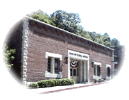 State. The original banking location was at 75 Spring Street in the former Clark and Klock Building...In 1966 the McGinnis property was purchased at 70 South Main Street
 and is where the main bank building now sits...The new buildingreflected the turn-of-the-century atmosphere of the town, incorporating motifs of earlier days...In 1978, the Board enlarged and remodeled the Bank. Taking note of the approaching Centennial of Eureka Springs in 1979, they chose to create the look of a truly historical Bank. The stone used was from the same quarry that had provided stone for many of the buildings in Eureka Springs."
- Eureka Springs, Arkansas - the Basin Park Hotel (photograph and history) (The following quote is used with the permission of Positive Idea Marketing Plans.) "Like the Crescent Hotel and many other buildings in town, the limestone quarry near the town of Beaver provided the rock exterior of the hotel. There are several horizontal rows of red dolomite around this building. Although very evident when built, it is quite easy to miss seeing the red dolomite now." (1905)
- Eureka Springs, Arkansas - the Crescent Hotel (photograph) Many of the buildings in Eureka Springs, including the Crescent Hotel, were built with stone from the limestone quarry near the town of Beaver. (Opened May 20, 1886)
- Fort Smith, Crawford County, Arkansas - Building the Second Fort Smith, presented by the Fort Smith National Historic Site. After Congress authorized reoccupation and enlargement of the post at Fort Smith, a stone quarry was opened at Belle Point.
- Fort Smith, Arkansas – the First Presbyterian Church – the Floor. From "The Restoration," by Ben Boulden, Times Record, Posted: Monday, February 2, 2004. This article is on the construction project which restored the 105-year-old sanctuary and chapel. Works on the construction began in June 2003 and the projected end was to be the end of February 2004. It was decided to use two types of limestone from a quarry in Batesville for the floor.
- Little Rock,
Arkansas - Courthouse and Post Office (Constructed in
1881) The Little Rock Courthouse and Post Office were constructed
of brick with a Cabin Creek Arkansas sandstone foundation. Red Missouri
granite was used for the base and water table, and buff Berea, Ohio,
sandstone was used in the upper stories. In 1897 the north courtroom
was added, which used Tennessee gray marble and Tennessee pink marble
borders. During the restoration faux marble veining was used to match
the existing marble. (The link from which the above information was obtained is no
longer available.)
<http://www.arb.uscourts.gov/Court Information/building.htm> - Little Rock, Arkansas - State Capitol - Virtual Tour. The exterior of the Capitol and the columns are limestone, which was quarried in Batesville, Arkansas.
- North Little
Rock, Arkansas – the Howell-Garner-Monfee House – 3 Fireplaces. (This information was obtained from the "Attractions and Historic Places" section of the North Little Rock web site.) (The link from which the following information was obtained is no longer available.)
<http://www.northlittlerock.org/history.html>The house is located at 300 West 4th Street, and the house was built in 1906. In 1940 three fireplaces of Arkansas marble were added.
- West Fork (near), Washington County, Arkansas – Devil’s Den State Park – Stone Structures & Stone Dam that spans Lee Creek
- Winslow (south of), Arkansas – the Ozark Folkways Heritage Center Building (photograph and history) Arkansas sandstone was used in the construction of the building in which this organization is located. There is a photograph of the building on the web site.
- Ozark Folkways Heritage Center (Building) History
According to the Devil’s Den State Park, “The Civilian Conservation Corps, the ‘Tree Army’ of Franklin D. Roosevelt’s New Deal, began building this park in the 1930s during the Great Depression. The camp enrollees who worked here created a lasting legacy. The park stands as a tribute to their craftsmanship and conservation achievements. This area has been designated a National Historic District and holds what has been called the most complete example of CCC park architecture. Lee Creek Valley provided the native wood and stone that the CCC used to craft the park’s CCC/Rustic Style buildings, a native stone dam, a unique pavilion/restaurant, cabins in several styles, roads, trails, stone walls, bridges, and the Yellow Rock Overlook.”
- The Finished Product from
Arkansas Stone used in Illinois
- Urbana-Champaign, Illinois - University
of Illinois - the Natural Resources Building. The
floor and stairs at the east entrance interior are built with "...the
brown to dark brown limestone that contains very light brown speckles
is Nerobi Marble. It came from a bed in the Warsaw Formation at Carthage
quarry. The dark grayish brown stone with the streaks of light grayish
brown mottles is Dark Plattin Marble was used for the lower wall veneer,
pillar and baseboard. This stone was supplied by the Carthage Marble
Company, and 'was probably extracted from a quarry near Batesville
in north-central Arkansas.'" (The link from which this
information was obtained is no longer available.)
<http://www.isgs.uiuc.edu/build/fulltext.html>
- Urbana-Champaign, Illinois - University
of Illinois - the Natural Resources Building. The
floor and stairs at the east entrance interior are built with "...the
brown to dark brown limestone that contains very light brown speckles
is Nerobi Marble. It came from a bed in the Warsaw Formation at Carthage
quarry. The dark grayish brown stone with the streaks of light grayish
brown mottles is Dark Plattin Marble was used for the lower wall veneer,
pillar and baseboard. This stone was supplied by the Carthage Marble
Company, and 'was probably extracted from a quarry near Batesville
in north-central Arkansas.'" (The link from which this
information was obtained is no longer available.)
- The Finished Product from
Arkansas Stone used in New York
- New York City, Missouri - the Dodge Building (Advertisement from Throvgh The Ages Magazine, November 1923, Vol. 1, No. 7, pp. 47.)
Phenix Marble Company, Kansas City, Missouri
Napoleon Gray and Other Marbles
In the Dodge Building, New York City, is one of the many examples of where Napoleon Gray has been used with other marbles. Here Shape, Bready & Feterkin, the architects, have covered the walls of the main and elevator entrances with Napoleon Gray to ceiling height. As a contrast, yet in harmony, a Batesville Marble floor bordered with Belgian Grand Antique has been used. Marble manufactured by Ital-American Marble Co. Napoleon Gray harmonizes with most marbles. We’d be glad to send you information or samples at any time that you request.
- New York City, Missouri - the Dodge Building (Advertisement from Throvgh The Ages Magazine, November 1923, Vol. 1, No. 7, pp. 47.)
- The Finished Product from
Arkansas Stone used in Washington, D.C.
- Washington, D. C. – the
Arkansas Memorial Stone in the Washington
Monument (photograph of stone and history) This web site is presented
by the National Park Service. The stone donated by the state of Arkansas
for inclusion in the Washington Monument was Arkansas Brown Limestone.
The National Park Service web site presents the memorial stones in placed in the interior of the Washington Monument. The Arkansas Memorial Stone entry reads as follows and can be viewed on the National Park Service’s web site in either the “Album” or the “Slide Show.”
The information and photograph of the stone from Alaska for the Washington Monument can found in “WAMO Stones Section 2.”
The Washington Monument web site has recently been redesigned. Below is an description that was available on the National Park Service web site in January 2008 that describes the Memorial Stones in the Washington Monument.
“A unique feature of the Washington Monument is the 193 memorial stones that adorn the interior of the monument. Starting in July 1848 the Washington National Monument Society invited states, cities and patriotic societies to contribute Memorial Stones. The Society listed some requirements to be followed. They asked that the stone be durable, a product of the state’s soil, and meet the following dimensions; four feet long, two feet high and 18 inches thick. These stones pay tribute to the character and achievements of George Washington. These traits are not only admired by Americans but by people the world over as seen by the number of stones donated by foreign countries. Below is a list of stones donated by state. In the near future all the stones will be online.
“While viewing the stones please keep in mind that the Washington Monument has undergone extensive renovation over the last three years. A key component of the project has been the restoration of the memorial stones. Over the years the stones have been damaged by moisture and vandalism. The pictures that follow show the condition of the stones before their restoration. In the upcoming months new images will be added highlighting the restored stones.”
The information and photograph of the stone from Alaska for the Washington Monument can found in “ WAMO Stones Section 2.”
Name: Arkansas
Level: 30-ft.
Donor: State of Arkansas
Dates: 1850/1850
Original material: limestone
Dimensions: 2’ x 4’
Sculptor/Carver: not known
Original inscription: Arkansas
Documented material history:
• 1849-50: In 1834 [sic] [Peter Beller], with the three Harp brothers, was commissioned to quarry a block of marble, six feet long, four feet wide and two feet thick for inclusion in the famed monument to the father of our country then being erected in the nation’s capitol. It was a difficult, tedious and time-consuming task in those days when quarrying had to be done with hand drills and wedges....The huge block of marble was eventually broken loose from Marble Mountain [near the town of Marble Falls]. Weighing about a ton, it was loaded onto a heavy sledge or stone-boat and skidded and hauled by a team of twenty oxen over the rough country of the Ozark and Boston mountains, a distance of about 50 miles, to the Arkansas River where it was shipped by barge to New Orleans and thence by sailing vessel to the Potomac basin where the Washington Monument was being erected.” [Victor A. Croley, “ Marble Falls Has Had Many Names,” Arkansas Gazette, March 23, 1969.]
• 1850: “The Arkansas Block of Marble for the Washington monument was shipped at Van Buren Dec 1. It weighs 2200 lbs, was contributed by citizens of several western counties, and when it reaches Washington Senator Borland will have it prepared, and the Arkansas arms cut in it at his own expense.” [The Sun (Baltimore), January 8, 1850.]
• 1850: “January 8, 1850 and February 12, 1850 from the Hon. Solon Borland of Arkansas stating that the block had been shipped....February 19, 1850 A letter was received from the I.S. Henderson Co. stating that the block from Arkansas had been forwarded from Baltimore.” [MR]
• 1850: “From Arkansas, a block of limestone of a brownish tint, the required dimensions, and the name of the State in large raised letters.” [DNI, August 7, 1850.]
• 1850s: “[Arkansas has] presented a block of native lime-stone somewhat variegated....” [RW]
Additional documented material information: Stone monument on west side of Scenic Highway 7 just across from Dogpatch (formerly Marble Falls), Arkansas: “This Marker Commemorates the Arkansas Marble in Washington’s Monument Taken by Beller and Harp Bros. from this Hill in 1836 [sic] This Marker Erected 1954 by Newton Co. History Society - W.F. Lackey Pres. Manda Hickman Sec.”
Images:
• 1850s Wilcox drawing
• 1880 Gedney drawing
• 1957 Allen photograph
• 1974 photograph
• 1980 photograph
• 2000 NPS slides
- Washington, D. C. – the
Arkansas Memorial Stone in the Washington
Monument (The photograph of the Arkansas Memorial stone monument on the left below was contributed by Abby Burnett. She stated that the stone contributed to the Washington monument was quarried in the vicinity of the road marker/monument. The older photograph of the monument on the right was contributed by Russell T. Johnson, who maintains the The Arkansas Roadside Travelogue web site. If you have any knowledge of the exact location of the place from which the stone was taken, please contact me. Peggy B. Perazzo.)


Memorial to the Arkansas stone contributed to the Washington Monument (Photograph by Abby Burnett)
Washington Monument Marble Quarry monument (Photograph by Russell T. Johnson)
- Washington, D. C. – the
Arkansas Memorial Stone in the Washington
Monument (photograph of stone and history) This web site is presented
by the National Park Service. The stone donated by the state of Arkansas
for inclusion in the Washington Monument was Arkansas Brown Limestone.


Stone Carvers, Stone Cutters, etc., Arkansas
- Carroll County, Arkansas, Stone Carvers – “Carvers of Carroll County,” by Abby Burnett and Vineta Wingate, Carroll County Historical Quarterly 53 (Sept. 2008): 22-26, 47.
- “Lucy J. Daniel (1865–1957)” from the Arkansas Encyclopedia of History & Culture.
- The Kruegers of The Pfeiffer Stone Company,” by Wilson Powell, The Independence County Chronicle 15 (July 1974): 13 - 35.
- Newton County, Arkansas, Tombstone Carvers – “Tombstone Carvers of Newton County,” by Abby Burnett, The Newton County Homestead, Journal of the Newton County Historical Society (2009): 8-11.
- “Nick Miller (1846 – 1898),” by Abby Burnett, Encyclopedia of Arkansas History & Culture, updated 2009.
- Nick Miller, Tombstone Carver – “My Soul From Out This Shadow Shall Be Lifted Nevermore; Nick Miller, Tombstone Carver, 1846 – 1898,” by Abby Burnett, Carroll County Historical Quarterly 53 (June 2008): 17-22.
- “Nick Miller: Tombstone Carver Lies in Unmarked Grave,” by Abby Burnett, The Ozarks Mountaineer 57 (March/April 2009): 52-55.
- A. H. Morley & Family, Fayetteville Tombstone Carvers – “‘No Pompous Marble To Thy Name We Raise’: A.H. Morley and Family, Fayetteville Tombstone Carvers,” by Abby Burnett, Flashback, Journal of the Washington County Historical Society 58 (Fall 2008): 115-145.
- A Stone Carver and His Trade in Arkansas – “‘Back in the Olden Days’ A Stone Cutter and His Trade,” by Charlote Cole, Manuscript student paper, 1979, Regional Studies Center at Lyon College, Batesville, Arkansas. [Note: a transcription of Cole’s taped interview with P.E. Stone, tombstone carver, is also available. The paper includes Cole’s drawings of Stone’s carving tools, a copy of a Pfeiffer Stone Company, Batesville, Ark. pamphlet titled “Crystalline Oolitic Marble ‘Arkansas White’” and excerpts from the Padgett Marble Company, Knoxville, Tennessee, Catalog No. 26, 1930.]
- H. J. Wiebusch, Stonecarver, Batesville, Arkansas – “H. J. Wiebusch, Batesville, Arkansas: A Nineteenth Century Stonecarver,” by Roberta D. Brown, Arkansas Historical Quarterly 42 (Autumn 1983): 197-206.
- H. J. Wiebusch, Stone Carver, Independence County, Arkansas – “Late Nineteenth Century Tombstone Iconography As Illustrated Through The Works of H. J. Wiebusch, Stone Carver, Independence County, Arkansas,” by Roberta D. Brown, The Independence County Chronicle, 25 (October 1983 – January 1984): 2-18.
- Howard F. Wolford, Sr. – Set in Stone; Howard F. Wolford, Sr., Quarryman, by Rene Jordan, 2015 [place of publication not identified; “printed in the United States.”]
(excerpt from the article) “In the late 1800s, it was so unusual for women to be stone carvers that The Monumental News, a trade journal, was able to locate only three to write about—one of whom was Lucy J. Daniel, formerly of Arkansas. The others were from Kansas and Canada, and all had learned the trade from their fathers. The journal article noted that Daniel had been fully in charge of the family’s marble shop since 1885, doing all the lettering, and some cutting and polishing, of the tombstones…..”
Lucy J. Daniel, Stone Carver – “Some Women Marble Cutters” (circa 1901) The article in the image is from The Monumental News Magazine, published circa 1901, pp. 120 (?). This article was included as one of the past articles of the magazine in the December, 1939 issue of The Monumental News Magazine. (Photo captions: Lucy J. Daniel, of Executor, Mo.; Alice E. Rigg, of Canada; & Pearl Sams, of Great Bend, Kansas.)
 |
“Some Women Marble Cutters,” from “The Monumental News,” circa 1901. |
Commercial use of material within this site is strictly prohibited. It is not to be captured, reworked, and placed inside another web site ©. All rights reserved. Peggy B. and George (Pat) Perazzo.